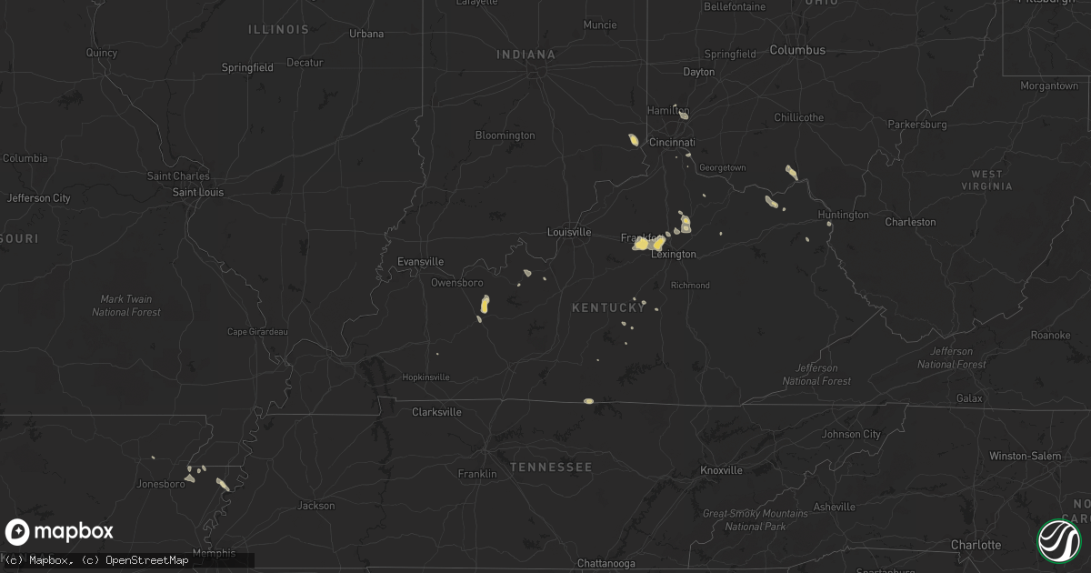
Hail Map in Kentucky on August 11, 2018
Get this storm
August 11 map
$229
one time, instant access
Download today. No call, no setup
Keep the $229
Bought the map and want the full workflow? Apply the entire $229 to a subscription within 7 days. None of it is wasted.
Every map, not just this one
This buys you this map. Subscription and you get every map we run, in the markets you choose from a few cities to whole states to nationwide. Plus real-time alerts the moment a storm fires.
Contact data
Name, contact info, occupancy, even credit band for addresses in the footprint. You go from where it hit to who to call.
Become the source they trust
Unlimited branding weather history reports on demand. You already have the documented answer ready for the property owner, and you are the one who showed up with it.
Property data and RoofTrace estimates
Pull up any address you have got, its value and the exact code rules for that jurisdiction, straight from One Click Code. Then RoofTrace estimates the squares, pitch, and roof value, priced the way you price.
Storm reports in Kentucky
Kentucky
| Date | Description |
|---|---|
| 08/11/20186:33 PM CDT | 1 tree down. |
| 08/11/20185:56 PM CDT | Tree down in millville. |
| 08/11/20185:44 PM CDT | 1 small tree down. |
| 08/11/20185:35 PM CDT | Multiple trees down in three different areas in midway. |
| 08/11/20185:30 PM CDT | At least 5 large trees down in southern scott county. Some power outages also. |
| 08/11/20184:53 PM CDT | One large tree down near scott and vine in paris. Two other trees down near 833 brentsville rd. |
| 08/11/20184:35 PM CDT | Tree downed in 4000 block of lower river road. Time estimated by radar. |
| 08/11/20184:21 PM CDT | Large tree down in cynthiana. Time estimated from radar. |
| 08/11/20184:15 PM CDT | A couple of trees downed along/near ky 19 in the southern part of the county. Time estimated. |
| 08/11/20183:28 PM CDT | Tree reported down along austin branch road. |
| 08/11/20183:22 PM CDT | Tree downed near 5000 block of idlewild road. Time estimated by radar. |
| 08/11/201812:40 PM CDT | Limbs down along raikes mill road. |
| 08/11/20187:50 AM CDT | At 1249 PM EDT, a severe thunderstorm was located near Lucasville, moving east at 20 mph. HAZARD...60 mph wind gusts and quarter size hail. SOURCE...Radar indicated. IMPACT...Minor hail damage to vehicles is possible. Expect wind damage to trees and power lines. Locations impacted include... Portsmouth, Wheelersburg, New Boston, Rosemount, Clarktown, Lucasville, Sciotodale, Lombardsville, Minford, West Portsmouth, Mcdermott, Portsmouth Regional Airport and Bear Creek. |
| 08/11/20183:12 AM CDT | At 812 PM CDT, a severe thunderstorm was located 7 miles northeast of Celina, moving east at 20 mph. HAZARD...60 mph wind gusts and quarter size hail. SOURCE...Radar indicated. IMPACT...Hail damage to vehicles is expected. Expect wind damage to roofs, siding, and trees. Locations impacted include... Littrell, Peytonsburg, Hegira, Kettle, Raydure, Frogue, Green Grove and Ashlock. |
| 08/11/20183:11 AM CDT | At 810 PM CDT, a severe thunderstorm was located near Celina, moving east at 20 mph. HAZARD...60 mph wind gusts and nickel size hail. SOURCE...Radar indicated. IMPACT...Expect damage to roofs, siding, and trees. Locations impacted include... Celina, Byrdstown, Wolf River Dock and Dale Hollow Lake. |
| 08/11/20182:27 AM CDT | At 727 PM EDT, a severe thunderstorm was located near Lawrenceburg, moving south at 5 mph. HAZARD...60 mph wind gusts and penny size hail. SOURCE...Radar indicated. IMPACT...Expect damage to roofs, siding, and trees. Locations impacted include... Frankfort, Lawrenceburg, Slickway, Farmdale, Capital City Airport, Broadville Manor, Avenstoke, Tyrone, Alton and Bridgeport. |
| 08/11/20181:56 AM CDT | At 656 PM EDT, Doppler radar indicated a severe thunderstorm capable of producing damaging winds in excess of 60 mph. This storm was located over Cardinal Hill, and moving southeast at 15 mph. Locations impacted include... Lexington, Georgetown, Versailles, Meadowthorpe, Dunbar High School, Cardinal Hill, Cadentown, Northland, Highlands and U K Arboretum. |
| 08/11/20181:42 AM CDT | At 642 PM EDT, a severe thunderstorm was located near Frankfort, moving south at 10 mph. HAZARD...60 mph wind gusts and penny size hail. SOURCE...Radar indicated. IMPACT...Expect damage to roofs, siding, and trees. Locations impacted include... Frankfort, Lawrenceburg, Slickway, Farmdale, Tyrone, Alton, Big Eddy, Jett, Duckers and Millville. |
| 08/11/20181:24 AM CDT | At 624 PM EDT, a severe thunderstorm was located near Georgetown, moving southeast at 15 mph. HAZARD...60 mph wind gusts. SOURCE...Radar indicated. IMPACT...Expect damage to roofs, siding, and trees. Locations impacted include... Lexington, Georgetown, Versailles, Meadowthorpe, Dunbar High School, Thoroughbred Acres, Cardinal Hill, Cadentown, Bryan Station and Northland. |
| 08/11/20181:11 AM CDT | At 610 PM EDT, a severe thunderstorm was located over Bethel, or 11 miles northwest of Owingsville, moving east at 5 mph. HAZARD...60 mph wind gusts and quarter size hail. SOURCE...Radar indicated. IMPACT...Hail damage to vehicles is expected. Expect wind damage to roofs, siding, and trees. Locations impacted include... Pecks Ridge, Bethel, Sherburne and Tilton. |
| 08/11/201812:53 AM CDT | At 553 PM EDT, a severe thunderstorm was located over Paris, moving southeast at 25 mph. HAZARD...60 mph wind gusts and penny size hail. SOURCE...Radar indicated. IMPACT...Expect damage to roofs, siding, and trees. Locations impacted include... Winchester, Paris, North Middletown, Sidville, Pretty Run, Shawhan, Blacks Crossroads, Constant Station, Ruddels Mills and Renick. |
| 08/10/20189:37 PM CDT | At 236 PM EDT, a severe thunderstorm was located over Camp Dix, or 11 miles northwest of Carter Caves State Park, moving southeast at 20 mph. HAZARD...60 mph wind gusts and penny size hail. SOURCE...Radar indicated. IMPACT...Expect damage to roofs, siding, and trees. Locations impacted include... Carter Caves State Park, Gesling, Load, Greenbo Lake, Carter, Brushart and Warnock.This includes Interstate 64 in Kentucky between mile markers 163 and170. |
All States Impacted by Hail Map on August 11, 2018
Cities Impacted by Hail Map on August 11, 2018
- Colorado City, AZ
- Hestand, KY
- Burkesville, KY
- Tompkinsville, KY
- Celina, TN
- Wagoner, OK
- Hulbert, OK
- Fort Gibson, OK
- Kingman, AZ
- Meadview, AZ
- Littlefield, AZ
- Clovis, NM
- Williams, AZ
- Brooksville, KY
- Luther, OK
- Weatherford, OK
- Jones, OK
- Clarendon, TX
- Elk Horn, KY
- Liberty, KY
- Versailles, KY
- Midway, KY
- Georgetown, KY
- Golden Valley, AZ
- Hackberry, AZ
- Peach Springs, AZ
- Auburn, IN
- Spencerville, IN
- Saint Joe, IN
- Bentonville, AR
- Beryl, UT
- Panguitch, UT
- Newport, NJ
- Kansas, OK
- Hennessey, OK
- Lexington, KY
- Rhodes, MI
- Luther, MI
- Baldwin, MI
- Winslow, AR
- Goldsboro, NC
- Arapaho, OK
- Frankfort, KY
- Lawrenceburg, KY
- Napoleon, OH
- Milford, UT
- Hedley, TX
- Lelia Lake, TX
- Plains, TX
- Overton, NV
- Dolan Springs, AZ
- Luxora, AR
- Clinton, OK
- Cynthiana, KY
- Paris, KY
- Marlin, TX
- Carlisle, KY
- Sharpsburg, KY
- Butler, OK
- Arcadia, OK
- Geary, OK
- Henderson, NC
- Middleville, MI
- Hastings, MI
- Glendale, UT
- Faison, NC
- Childress, TX
- Chelsea, MI
- Gregory, MI
- Munith, MI
- Grass Lake, MI
- Stockbridge, MI
- Parsons, TN
- Lexington, TN
- Decaturville, TN
- Darden, TN
- Jackson, TN
- Rose, OK
- Defiance, OH
- King Of Prussia, PA
- Wayne, PA
- Bullhead City, AZ
- Virginia Beach, VA
- Norfolk, VA
- Chesapeake, VA
- Decatur, AR
- Holgate, OH
- Vine Grove, KY
- Beech Grove, AR
- Bono, AR
- Guthrie, OK
- Coyle, OK
- Perkins, OK
- Spencer, WV
- Looneyville, WV
- Tahlequah, OK
- Chloe, WV
- Newton, WV
- Mangum, OK
- West Chester, OH
- Mason, OH
- Hamilton, OH
- Capron, VA
- Berryville, AR
- Smyrna, DE
- Townsend, DE
- Cardwell, MO
- Arbyrd, MO
- Fordsville, KY
- Dundee, KY
- Olaton, KY
- Hartford, KY
- Bannister, MI
- Elsie, MI
- Suffolk, VA
- Cordell, OK
- Paragonah, UT
- Boulder City, NV
- Latonia, KY
- Elkhart Lake, WI
- Dansville, MI
- Albuquerque, NM
- Emporia, VA
- Crofton, KY
- Milan, MI
- Aurora, IN
- Trenton, OH
- Rodney, MI
- Mecosta, MI
- West Fork, AR
- Jackson, MI
- Brooklyn, MI
- McDermott, OH
- West Portsmouth, OH
- Nazareth, TX
- Tulia, TX
- Olustee, OK
- Chickasha, OK
- Amber, OK
- Conshohocken, PA
- Villanova, PA
- Gladwyne, PA
- Beaver Dam, KY
- Reynolds Station, KY
- Catlettsburg, KY
- Tijeras, NM
- Edgewood, NM
- Bristow, OK
- Pollocksville, NC
- Trenton, NC
- Jamesville, NC
- Bells, TN
- Bentley, MI
- Guilford, IN
- Lawrenceburg, IN
- Moores Hill, IN
- Elkton, MD
- Oxford, PA
- Rising Sun, MD
- Gravel Switch, KY
- Danville, KY
- Perryville, KY
- Media, PA
- Duck, WV
- Nebo, WV
- Wallback, WV
- Jacksonville, NC
- Dover, OK
- Leachville, AR
- Monette, AR
- Black Oak, AR
- Lake City, AR
- Vanceburg, KY
- Washington, UT
- Blytheville, AR
- Riesel, TX
- Reagan, TX
- California, KY
- Melrose, NM
- Chestertown, MD
- Lawrenceville, VA
- New Holstein, WI
- Mount Olive, NC
- East Greenville, PA
- Coopersburg, PA
- Zionsville, PA
- Beggs, OK
- Freeport, MI
- Granite, OK
- Bronson, TX
- Pineland, TX
- Grabill, IN
- Butler, IN
- Leo, IN
- Sunman, IN
- Oaks, OK
- Portsmouth, OH
- Lucasville, OH
- Vinson, OK
- Stanley, NM
- Grayson, KY
- Olive Hill, KY
- Muleshoe, TX
- Newsoms, VA
- Franklin, VA
- Stanford, KY
- Chandler, OK
- Happy, TX
- Texico, NM
- Pioneer, OH
- Courtland, VA
- Sparks, OK
- Galena, MO
- Cape Fair, MO
- Prescott, AZ
- Charlotte, TX
- Stamping Ground, KY
- Hollywood, FL
- Norlina, NC
- Manson, NC
- Portsmouth, VA
- Friona, TX
- Garfield, KY
- Harned, KY
- Napoleon, MI
- Norvell, MI
- Webberville, MI
- Kellyville, OK
- Corn, OK
- Seven Springs, NC
- Dudley, NC
- Blanchard, OK
- Dunnville, KY
- Columbia, KY
- Como, NC
- Millsboro, DE
- Frankford, DE
- Kingfisher, OK
- Melbourne, KY
- New Richmond, OH
- Coats, NC
- Guston, KY
- Irvington, KY
- Hydro, OK
- Bryn Mawr, PA
- Haverford, PA
- Bovina, TX
- Hudson, MI
- Washington Boro, PA
- Millersville, PA
- Hereford, TX
- Vidalia, LA
- Hope, MI
- Junction City, KY
- Bullock, NC
- Webbville, KY
- Middletown, DE
- Beaverton, MI
- Sedona, AZ


