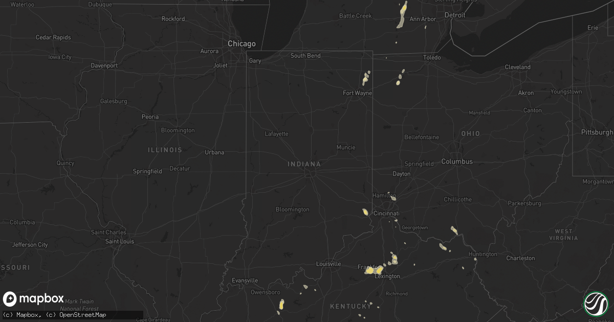
Hail Map in Indiana on August 11, 2018
Get this storm
August 11 map
$229
one time, instant access
Download today. No call, no setup
Keep the $229
Bought the map and want the full workflow? Apply the entire $229 to a subscription within 7 days. None of it is wasted.
Every map, not just this one
This buys you this map. Subscription and you get every map we run, in the markets you choose from a few cities to whole states to nationwide. Plus real-time alerts the moment a storm fires.
Contact data
Name, contact info, occupancy, even credit band for addresses in the footprint. You go from where it hit to who to call.
Become the source they trust
Unlimited branding weather history reports on demand. You already have the documented answer ready for the property owner, and you are the one who showed up with it.
Property data and RoofTrace estimates
Pull up any address you have got, its value and the exact code rules for that jurisdiction, straight from One Click Code. Then RoofTrace estimates the squares, pitch, and roof value, priced the way you price.
Storm reports in Indiana
Indiana
| Date | Description |
|---|---|
| 08/11/20184:19 PM CDT | Two trees were reported knocked down on soap hill road. |
| 08/11/20182:34 AM CDT | At 734 PM EDT, a severe thunderstorm was located near Grabill, or near Auburn, moving southwest at 15 mph. HAZARD...60 mph wind gusts and quarter size hail. SOURCE...Radar indicated. IMPACT...Hail damage to vehicles is expected. Expect wind damage to roofs, siding, and trees. Locations impacted include... Fort Wayne, New Haven, Huntertown, Grabill, St. Joe, Leo-cedarville, Concord, Saint Johns, Harlan, Wallen, Spencerville In Dekalb County, Cuba and Saint Joe.This includes the following highways... Interstate 469 between mile markers 24 and 30. Interstate 69 in Indiana between mile markers 309 and 325. |
All States Impacted by Hail Map on August 11, 2018
Cities Impacted by Hail Map on August 11, 2018
- Colorado City, AZ
- Hestand, KY
- Burkesville, KY
- Tompkinsville, KY
- Celina, TN
- Wagoner, OK
- Hulbert, OK
- Fort Gibson, OK
- Kingman, AZ
- Meadview, AZ
- Littlefield, AZ
- Clovis, NM
- Williams, AZ
- Brooksville, KY
- Luther, OK
- Weatherford, OK
- Jones, OK
- Clarendon, TX
- Elk Horn, KY
- Liberty, KY
- Versailles, KY
- Midway, KY
- Georgetown, KY
- Golden Valley, AZ
- Hackberry, AZ
- Peach Springs, AZ
- Auburn, IN
- Spencerville, IN
- Saint Joe, IN
- Bentonville, AR
- Beryl, UT
- Panguitch, UT
- Newport, NJ
- Kansas, OK
- Hennessey, OK
- Lexington, KY
- Rhodes, MI
- Luther, MI
- Baldwin, MI
- Winslow, AR
- Goldsboro, NC
- Arapaho, OK
- Frankfort, KY
- Lawrenceburg, KY
- Napoleon, OH
- Milford, UT
- Hedley, TX
- Lelia Lake, TX
- Plains, TX
- Overton, NV
- Dolan Springs, AZ
- Luxora, AR
- Clinton, OK
- Cynthiana, KY
- Paris, KY
- Marlin, TX
- Carlisle, KY
- Sharpsburg, KY
- Butler, OK
- Arcadia, OK
- Geary, OK
- Henderson, NC
- Middleville, MI
- Hastings, MI
- Glendale, UT
- Faison, NC
- Childress, TX
- Chelsea, MI
- Gregory, MI
- Munith, MI
- Grass Lake, MI
- Stockbridge, MI
- Parsons, TN
- Lexington, TN
- Decaturville, TN
- Darden, TN
- Jackson, TN
- Rose, OK
- Defiance, OH
- King Of Prussia, PA
- Wayne, PA
- Bullhead City, AZ
- Virginia Beach, VA
- Norfolk, VA
- Chesapeake, VA
- Decatur, AR
- Holgate, OH
- Vine Grove, KY
- Beech Grove, AR
- Bono, AR
- Guthrie, OK
- Coyle, OK
- Perkins, OK
- Spencer, WV
- Looneyville, WV
- Tahlequah, OK
- Chloe, WV
- Newton, WV
- Mangum, OK
- West Chester, OH
- Mason, OH
- Hamilton, OH
- Capron, VA
- Berryville, AR
- Smyrna, DE
- Townsend, DE
- Cardwell, MO
- Arbyrd, MO
- Fordsville, KY
- Dundee, KY
- Olaton, KY
- Hartford, KY
- Bannister, MI
- Elsie, MI
- Suffolk, VA
- Cordell, OK
- Paragonah, UT
- Boulder City, NV
- Latonia, KY
- Elkhart Lake, WI
- Dansville, MI
- Albuquerque, NM
- Emporia, VA
- Crofton, KY
- Milan, MI
- Aurora, IN
- Trenton, OH
- Rodney, MI
- Mecosta, MI
- West Fork, AR
- Jackson, MI
- Brooklyn, MI
- McDermott, OH
- West Portsmouth, OH
- Nazareth, TX
- Tulia, TX
- Olustee, OK
- Chickasha, OK
- Amber, OK
- Conshohocken, PA
- Villanova, PA
- Gladwyne, PA
- Beaver Dam, KY
- Reynolds Station, KY
- Catlettsburg, KY
- Tijeras, NM
- Edgewood, NM
- Bristow, OK
- Pollocksville, NC
- Trenton, NC
- Jamesville, NC
- Bells, TN
- Bentley, MI
- Guilford, IN
- Lawrenceburg, IN
- Moores Hill, IN
- Elkton, MD
- Oxford, PA
- Rising Sun, MD
- Gravel Switch, KY
- Danville, KY
- Perryville, KY
- Media, PA
- Duck, WV
- Nebo, WV
- Wallback, WV
- Jacksonville, NC
- Dover, OK
- Leachville, AR
- Monette, AR
- Black Oak, AR
- Lake City, AR
- Vanceburg, KY
- Washington, UT
- Blytheville, AR
- Riesel, TX
- Reagan, TX
- California, KY
- Melrose, NM
- Chestertown, MD
- Lawrenceville, VA
- New Holstein, WI
- Mount Olive, NC
- East Greenville, PA
- Coopersburg, PA
- Zionsville, PA
- Beggs, OK
- Freeport, MI
- Granite, OK
- Bronson, TX
- Pineland, TX
- Grabill, IN
- Butler, IN
- Leo, IN
- Sunman, IN
- Oaks, OK
- Portsmouth, OH
- Lucasville, OH
- Vinson, OK
- Stanley, NM
- Grayson, KY
- Olive Hill, KY
- Muleshoe, TX
- Newsoms, VA
- Franklin, VA
- Stanford, KY
- Chandler, OK
- Happy, TX
- Texico, NM
- Pioneer, OH
- Courtland, VA
- Sparks, OK
- Galena, MO
- Cape Fair, MO
- Prescott, AZ
- Charlotte, TX
- Stamping Ground, KY
- Hollywood, FL
- Norlina, NC
- Manson, NC
- Portsmouth, VA
- Friona, TX
- Garfield, KY
- Harned, KY
- Napoleon, MI
- Norvell, MI
- Webberville, MI
- Kellyville, OK
- Corn, OK
- Seven Springs, NC
- Dudley, NC
- Blanchard, OK
- Dunnville, KY
- Columbia, KY
- Como, NC
- Millsboro, DE
- Frankford, DE
- Kingfisher, OK
- Melbourne, KY
- New Richmond, OH
- Coats, NC
- Guston, KY
- Irvington, KY
- Hydro, OK
- Bryn Mawr, PA
- Haverford, PA
- Bovina, TX
- Hudson, MI
- Washington Boro, PA
- Millersville, PA
- Hereford, TX
- Vidalia, LA
- Hope, MI
- Junction City, KY
- Bullock, NC
- Webbville, KY
- Middletown, DE
- Beaverton, MI
- Sedona, AZ


