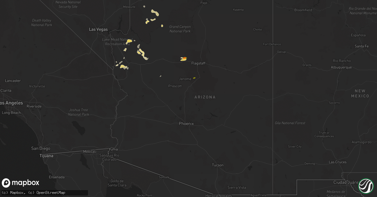
Hail Map in Arizona on August 11, 2018
Get this storm
August 11 map
$229
one time, instant access
Download today. No call, no setup
Keep the $229
Bought the map and want the full workflow? Apply the entire $229 to a subscription within 7 days. None of it is wasted.
Every map, not just this one
This buys you this map. Subscription and you get every map we run, in the markets you choose from a few cities to whole states to nationwide. Plus real-time alerts the moment a storm fires.
Contact data
Name, contact info, occupancy, even credit band for addresses in the footprint. You go from where it hit to who to call.
Become the source they trust
Unlimited branding weather history reports on demand. You already have the documented answer ready for the property owner, and you are the one who showed up with it.
Property data and RoofTrace estimates
Pull up any address you have got, its value and the exact code rules for that jurisdiction, straight from One Click Code. Then RoofTrace estimates the squares, pitch, and roof value, priced the way you price.
Storm reports in Arizona
Arizona
| Date | Description |
|---|---|
| 08/11/20184:50 PM CDT | Report of quarter to half dollar size hail. |
| 08/11/20183:45 PM CDT | Soft hail... Some plants in the garden were shredded... No damage to metal structures. |
| 08/11/20183:25 PM CDT | Hail up to the size of a golf ball was reported at the koa campground north of williams. |
| 08/11/20187:41 AM CDT | At 1241 PM MST, a severe thunderstorm was located near Williams, or 27 miles west of Flagstaff, moving west at 15 mph. HAZARD...60 mph wind gusts and half dollar size hail. SOURCE...Radar indicated. IMPACT...Hail damage to vehicles is expected. Expect wind damage to roofs, siding, and trees. Locations impacted include... Williams, Dogtown Lake Campground and Kaibab Lake Campground. This includes the following highways... Business Interstate 40 between mile markers 163 and 165. Interstate 40 between mile markers 153 and 175. State Route 64 between mile markers 186 and 197. |
| 08/11/20183:39 AM CDT | At 837 PM PDT/837 PM MST/, severe thunderstorms were located along a line extending from the Sheep Mountains to Willow Beach, moving southwest at 30 mph. HAZARD...70 mph wind gusts. SOURCE...Radar indicated. IMPACT...Expect considerable tree damage. Damage is likely to mobile homes, roofs, and outbuildings. Locations impacted include... Las Vegas, Henderson, North Las Vegas, Boulder City, Rainbow Canyon, Summerlin, Nellis AFB, Red Rock Canyon, Green Valley, Spring Mountains, Paradise, Lone Mountain, Anthem, Mountains Edge, The Strip, Blue Diamond, Downtown Las Vegas, East Las Vegas, Sam Boyd Stadium and Southern Highlands.This includes Interstate 15 in Nevada between mile markers 17 and 25. |
| 08/11/20183:07 AM CDT | At 806 PM PDT/806 PM MST/, severe thunderstorms were located along a line extending from 20 miles north of Aliante to Callville Bay, moving southwest at 30 mph. HAZARD...60 mph wind gusts. SOURCE...Radar indicated. IMPACT...Expect damage to roofs and trees. Locations impacted include... Las Vegas, Henderson, North Las Vegas, Boulder City, Rainbow Canyon, Summerlin, Nellis AFB, Red Rock Canyon, Green Valley, Spring Mountains, Paradise, Lone Mountain, Anthem, Mountains Edge, The Strip, Blue Diamond, Downtown Las Vegas, East Las Vegas, Sam Boyd Stadium and Southern Highlands.This includes Interstate 15 in Nevada between mile markers 17 and 25. |
| 08/11/20182:40 AM CDT | At 738 PM PDT/738 PM MST/, severe thunderstorms were located along a line extending from 7 miles northwest of Valley Of Fire to 6 miles east of Echo Bay, moving southwest at 25 mph. HAZARD...60 mph wind gusts. SOURCE...Radar indicated. IMPACT...Expect damage to roofs and trees. Locations impacted include... North Las Vegas, Boulder City, Nellis AFB, Lake Las Vegas, Overton, Moapa Town, East Las Vegas, Moapa Valley, Echo Bay, Meadview, Hoover Dam, South Cove, Boulder Beach, and Callville Bay.This includes Interstate 15 in Nevada between mile markers 60 and 83,and between mile markers 85 and 91. |
| 08/11/20182:37 AM CDT | At 735 PM PDT/735 PM MST/, a severe thunderstorm was located near Cottonwood Cove, or 15 miles northeast of Katherine Landing, moving southwest at 30 mph. HAZARD...50 to 60 mph wind gusts. SOURCE...Radar indicated. IMPACT...Expect damage to roofs and trees. Locations impacted include... Cottonwood Cove and Cottonwood Cove Campground. |
| 08/11/20181:47 AM CDT | At 646 PM MST, a severe thunderstorm was located near Grand Canyon Ranch, or 43 miles north of Kingman, moving southwest at 30 mph. HAZARD...60 mph wind gusts and quarter size hail. SOURCE...Radar indicated. IMPACT...Hail damage to vehicles is expected. Expect wind damage to roofs and trees. Locations impacted include... Dolan Springs, Pierce Ferry And Antares Roads, Grand Canyon Ranch and Lake Mead National Recreation Area. |
| 08/11/20181:38 AM CDT | At 638 PM MST, a severe thunderstorm was located near Tucson, and is nearly stationary. HAZARD...60 mph wind gusts. SOURCE...Radar indicated. IMPACT...Expect damage to roofs, siding, and trees. Locations impacted include... Tucson, Flowing Wells, Casas Adobes, Drexel Heights, South Tucson and Catalina Foothills.This includes the following highways... Interstate 10 between mile markers 252 and 262. Interstate 19 between mile markers 61 and 63. Route 77 between mile markers 70 and 75. Route 86 between mile markers 170 and 171. |
| 08/11/201812:54 AM CDT | At 553 PM MST, a severe thunderstorm was located near Dolan Springs, or 26 miles north of Kingman, moving west at 5 mph. HAZARD...60 mph wind gusts and quarter size hail. SOURCE...Radar indicated. IMPACT...Hail damage to vehicles is expected. Expect wind damage to roofs and trees. Locations impacted include... Dolan Springs. |
| 08/11/201812:35 AM CDT | At 532 PM MST, a severe thunderstorm was located 18 miles southeast of Grand Canyon Ranch, or 37 miles northeast of Kingman, along Buck and Doe Road moving north at 5 mph. HAZARD...60 mph wind gusts and quarter size hail. SOURCE...Radar indicated. IMPACT...Hail damage to vehicles is expected. Expect wind damage to roofs and trees. Locations impacted include... Buck and Doe Road. |
| 08/10/201811:42 PM CDT | At 442 PM MST, a severe thunderstorm was located over Laguna Lake, or 69 miles west of Desert View at Grand Canyon, moving southwest at 10 mph. HAZARD...Ping pong ball size hail and 60 mph wind gusts. SOURCE...Radar indicated. IMPACT...People and animals outdoors will be injured. Expect hail damage to roofs, siding, windows, and vehicles. Expect wind damage to roofs, siding, and trees. Locations impacted include... Laguna Lake, Hualapai Reservation and Fraziers Well. |
| 08/10/201811:40 PM CDT | At 437 PM MST, a severe thunderstorm was located near Valentine along Route 66 between mile markers 84 and 99, or 29 miles northeast of Kingman, moving northwest at 20 mph. HAZARD...60 mph wind gusts and quarter size hail. SOURCE...Radar indicated. IMPACT...Hail damage to vehicles is expected. Expect wind damage to roofs and trees. Locations impacted include... Valentine and Route 66 and Peach Springs. |
| 08/10/201811:19 PM CDT | At 419 PM MST, a severe thunderstorm was located near Peeples Valley, or 22 miles north of Wickenburg, moving southwest at 15 mph. HAZARD...60 mph wind gusts and quarter size hail. SOURCE...Radar indicated. IMPACT...Hail damage to vehicles is expected. Expect wind damage to roofs, siding, and trees. Locations impacted include... Walnut Grove, Yarnell, Peeples Valley and Glen Ilah. This includes State Route 89 between mile markers 271 and 289. |
| 08/10/201811:08 PM CDT | Spotter reported that power is out along us 95 from bullhead city to fort mohave due to thunderstorm winds. |
| 08/10/201811:05 PM CDT | At 404 PM MST, a severe thunderstorm was located near Carrizo, or 26 miles southwest of Show Low, moving west at 15 mph. HAZARD...60 mph wind gusts and quarter size hail. SOURCE...Radar indicated. IMPACT...Hail damage to vehicles is expected. Expect wind damage to roofs, siding, and trees. Locations impacted include... Carrizo and Fort Apache Reservation. This includes Highway 60 between mile markers 299 and 316. |
| 08/10/201811:04 PM CDT | At 402 PM MST, a severe thunderstorm was located 7 miles west of Diamond M Ranch, or 32 miles east of Kingman, moving west at 10 mph. HAZARD...60 mph wind gusts and quarter size hail. SOURCE...Radar indicated. IMPACT...Hail damage to vehicles is expected. Expect wind damage to roofs and trees. Locations impacted include... Valentine.This includes Interstate 40 in Arizona near mile marker 70. |
| 08/10/201810:31 PM CDT | At 331 PM MST, a severe thunderstorm was located near Mayer, or 16 miles southeast of Prescott Valley, moving southwest at 10 mph. HAZARD...60 mph wind gusts and half dollar size hail. SOURCE...Radar indicated. IMPACT...Hail damage to vehicles is expected. Expect wind damage to roofs, siding, and trees. Locations impacted include... Mayer, Poland Junction, Cordes Junction, Cordes and Spring Valley. This includes the following highways... Interstate 17 between mile markers 261 and 267. State Route 69 between mile markers 263 and 280. |
| 08/10/201810:28 PM CDT | At 327 PM MST, a severe thunderstorm was located near Rose Well, or 57 miles west of Desert View at Grand Canyon, moving southwest at 10 mph. HAZARD...60 mph wind gusts and half dollar size hail. SOURCE...Radar indicated. IMPACT...Hail damage to vehicles is expected. Expect wind damage to roofs, siding, and trees. This severe thunderstorm will remain over mainly rural areas OF Coconino County. |
| 08/10/201810:11 PM CDT | At 310 PM MST, a severe thunderstorm was located near Rose Well, or 66 miles west of Desert View at Grand Canyon, moving southwest at 10 mph. HAZARD...60 mph wind gusts and half dollar size hail. SOURCE...Radar indicated. IMPACT...Hail damage to vehicles is expected. Expect wind damage to roofs, siding, and trees. Locations impacted include... Rose Well. |
| 08/10/20189:52 PM CDT | Wind gust of 58 mph reported from the union pass raws. |
| 08/10/20189:40 PM CDT | Corrected impact time. Spotter reported that power is out along us 95 from bullhead city to fort mohave due to thunderstorm winds. |
| 08/10/20189:35 PM CDT | 62 mph wind gust reported at bullhead city airport. |
| 08/10/20189:30 PM CDT | Several power poles down including a transmission line resulted in a city wide power outage. Multiple awnings damaged...a few trees down and a few homes had damage to t |
| 08/10/20189:26 PM CDT | At 226 PM MST, a severe thunderstorm was located 14 miles southwest of Jacob Lake, or 33 miles south of Kanab, moving southwest at 10 mph. HAZARD...60 mph wind gusts and quarter size hail. SOURCE...Radar indicated. IMPACT...Hail damage to vehicles is expected. Expect wind damage to roofs, siding, and trees. This severe thunderstorm will remain over mainly rural areas OF Coconino County. |
| 08/10/20189:25 PM CDT | Corrected impact time. Wind gust of 58 mph reported from the union pass raws. |
| 08/10/20189:19 PM CDT | At 218 PM MST, a severe thunderstorm was located 11 miles southwest of Rose Well, or 64 miles northeast of Kingman, moving southwest at 10 mph. HAZARD...60 mph wind gusts and quarter size hail. SOURCE...Radar indicated. IMPACT...Hail damage to vehicles is expected. Expect wind damage to roofs, siding, and trees. This severe thunderstorm will remain over mainly rural areas OF Coconino County. |
| 08/10/20188:30 PM CDT | At 129 PM MST, a severe thunderstorm was located near Williams, or 30 miles west of Flagstaff, moving west at 10 mph. HAZARD...60 mph wind gusts and half dollar size hail. SOURCE...Radar indicated. IMPACT...Hail damage to vehicles is expected. Expect wind damage to roofs, siding, and trees. Locations impacted include... Williams and Kaibab Lake Campground. This includes the following highways... Business Interstate 40 between mile markers 163 and 165. Interstate 40 between mile markers 152 and 169. State Route 64 between mile markers 186 and 198. |
All States Impacted by Hail Map on August 11, 2018
Cities Impacted by Hail Map on August 11, 2018
- Colorado City, AZ
- Hestand, KY
- Burkesville, KY
- Tompkinsville, KY
- Celina, TN
- Wagoner, OK
- Hulbert, OK
- Fort Gibson, OK
- Kingman, AZ
- Meadview, AZ
- Littlefield, AZ
- Clovis, NM
- Williams, AZ
- Brooksville, KY
- Luther, OK
- Weatherford, OK
- Jones, OK
- Clarendon, TX
- Elk Horn, KY
- Liberty, KY
- Versailles, KY
- Midway, KY
- Georgetown, KY
- Golden Valley, AZ
- Hackberry, AZ
- Peach Springs, AZ
- Auburn, IN
- Spencerville, IN
- Saint Joe, IN
- Bentonville, AR
- Beryl, UT
- Panguitch, UT
- Newport, NJ
- Kansas, OK
- Hennessey, OK
- Lexington, KY
- Rhodes, MI
- Luther, MI
- Baldwin, MI
- Winslow, AR
- Goldsboro, NC
- Arapaho, OK
- Frankfort, KY
- Lawrenceburg, KY
- Napoleon, OH
- Milford, UT
- Hedley, TX
- Lelia Lake, TX
- Plains, TX
- Overton, NV
- Dolan Springs, AZ
- Luxora, AR
- Clinton, OK
- Cynthiana, KY
- Paris, KY
- Marlin, TX
- Carlisle, KY
- Sharpsburg, KY
- Butler, OK
- Arcadia, OK
- Geary, OK
- Henderson, NC
- Middleville, MI
- Hastings, MI
- Glendale, UT
- Faison, NC
- Childress, TX
- Chelsea, MI
- Gregory, MI
- Munith, MI
- Grass Lake, MI
- Stockbridge, MI
- Parsons, TN
- Lexington, TN
- Decaturville, TN
- Darden, TN
- Jackson, TN
- Rose, OK
- Defiance, OH
- King Of Prussia, PA
- Wayne, PA
- Bullhead City, AZ
- Virginia Beach, VA
- Norfolk, VA
- Chesapeake, VA
- Decatur, AR
- Holgate, OH
- Vine Grove, KY
- Beech Grove, AR
- Bono, AR
- Guthrie, OK
- Coyle, OK
- Perkins, OK
- Spencer, WV
- Looneyville, WV
- Tahlequah, OK
- Chloe, WV
- Newton, WV
- Mangum, OK
- West Chester, OH
- Mason, OH
- Hamilton, OH
- Capron, VA
- Berryville, AR
- Smyrna, DE
- Townsend, DE
- Cardwell, MO
- Arbyrd, MO
- Fordsville, KY
- Dundee, KY
- Olaton, KY
- Hartford, KY
- Bannister, MI
- Elsie, MI
- Suffolk, VA
- Cordell, OK
- Paragonah, UT
- Boulder City, NV
- Latonia, KY
- Elkhart Lake, WI
- Dansville, MI
- Albuquerque, NM
- Emporia, VA
- Crofton, KY
- Milan, MI
- Aurora, IN
- Trenton, OH
- Rodney, MI
- Mecosta, MI
- West Fork, AR
- Jackson, MI
- Brooklyn, MI
- McDermott, OH
- West Portsmouth, OH
- Nazareth, TX
- Tulia, TX
- Olustee, OK
- Chickasha, OK
- Amber, OK
- Conshohocken, PA
- Villanova, PA
- Gladwyne, PA
- Beaver Dam, KY
- Reynolds Station, KY
- Catlettsburg, KY
- Tijeras, NM
- Edgewood, NM
- Bristow, OK
- Pollocksville, NC
- Trenton, NC
- Jamesville, NC
- Bells, TN
- Bentley, MI
- Guilford, IN
- Lawrenceburg, IN
- Moores Hill, IN
- Elkton, MD
- Oxford, PA
- Rising Sun, MD
- Gravel Switch, KY
- Danville, KY
- Perryville, KY
- Media, PA
- Duck, WV
- Nebo, WV
- Wallback, WV
- Jacksonville, NC
- Dover, OK
- Leachville, AR
- Monette, AR
- Black Oak, AR
- Lake City, AR
- Vanceburg, KY
- Washington, UT
- Blytheville, AR
- Riesel, TX
- Reagan, TX
- California, KY
- Melrose, NM
- Chestertown, MD
- Lawrenceville, VA
- New Holstein, WI
- Mount Olive, NC
- East Greenville, PA
- Coopersburg, PA
- Zionsville, PA
- Beggs, OK
- Freeport, MI
- Granite, OK
- Bronson, TX
- Pineland, TX
- Grabill, IN
- Butler, IN
- Leo, IN
- Sunman, IN
- Oaks, OK
- Portsmouth, OH
- Lucasville, OH
- Vinson, OK
- Stanley, NM
- Grayson, KY
- Olive Hill, KY
- Muleshoe, TX
- Newsoms, VA
- Franklin, VA
- Stanford, KY
- Chandler, OK
- Happy, TX
- Texico, NM
- Pioneer, OH
- Courtland, VA
- Sparks, OK
- Galena, MO
- Cape Fair, MO
- Prescott, AZ
- Charlotte, TX
- Stamping Ground, KY
- Hollywood, FL
- Norlina, NC
- Manson, NC
- Portsmouth, VA
- Friona, TX
- Garfield, KY
- Harned, KY
- Napoleon, MI
- Norvell, MI
- Webberville, MI
- Kellyville, OK
- Corn, OK
- Seven Springs, NC
- Dudley, NC
- Blanchard, OK
- Dunnville, KY
- Columbia, KY
- Como, NC
- Millsboro, DE
- Frankford, DE
- Kingfisher, OK
- Melbourne, KY
- New Richmond, OH
- Coats, NC
- Guston, KY
- Irvington, KY
- Hydro, OK
- Bryn Mawr, PA
- Haverford, PA
- Bovina, TX
- Hudson, MI
- Washington Boro, PA
- Millersville, PA
- Hereford, TX
- Vidalia, LA
- Hope, MI
- Junction City, KY
- Bullock, NC
- Webbville, KY
- Middletown, DE
- Beaverton, MI
- Sedona, AZ


