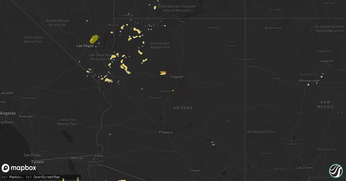
Hail Map on August 11, 2018
Get this storm
August 11 map
$229
one time, instant access
Download today. No call, no setup
Keep the $229
Bought the map and want the full workflow? Apply the entire $229 to a subscription within 7 days. None of it is wasted.
Every map, not just this one
This buys you this map. Subscription and you get every map we run, in the markets you choose from a few cities to whole states to nationwide. Plus real-time alerts the moment a storm fires.
Contact data
Name, contact info, occupancy, even credit band for addresses in the footprint. You go from where it hit to who to call.
Become the source they trust
Unlimited branding weather history reports on demand. You already have the documented answer ready for the property owner, and you are the one who showed up with it.
Property data and RoofTrace estimates
Pull up any address you have got, its value and the exact code rules for that jurisdiction, straight from One Click Code. Then RoofTrace estimates the squares, pitch, and roof value, priced the way you price.
States Impacted by Hail Map on August 11, 2018
Storm reports
Utah
| Date | Description |
|---|---|
| 08/11/20181:53 AM CDT | At 652 PM MDT, a severe thunderstorm was located over Santa Clara, or near St George, moving west at 40 mph. HAZARD...60 mph wind gusts and quarter size hail. SOURCE...Radar indicated. IMPACT...Hail damage to vehicles is expected. Expect wind damage to roofs, siding, and trees. Locations impacted include... St George, Washington, Hurricane, Santa Clara, Ivins, Motoqua, Bloomington, Gunlock, Veyo and Snow Canyon State Park. |
| 08/10/201811:35 PM CDT | At 434 PM MDT, a severe thunderstorm was located 11 miles south of Milford near SRs 129 and 21, moving west at 20 mph. HAZARD...60 mph wind gusts and quarter size hail. SOURCE...Radar indicated. IMPACT...Hail damage to vehicles is expected. Expect wind damage to roofs, siding, and trees. Locations impacted include... Milford, Minersville and Adamsville. |
| 08/10/20189:58 PM CDT | At 257 PM MDT, a severe thunderstorm was located near Panguitch, or 33 miles south of Junction, moving northwest at 20 mph in the vicinity of US-89. HAZARD...60 mph wind gusts and quarter size hail. SOURCE...Radar indicated. IMPACT...Hail damage to vehicles is expected. Expect wind damage to roofs, siding, and trees. Locations impacted include... Panguitch and Hillsdale. |
North Carolina
| Date | Description |
|---|---|
| 08/11/20183:25 PM CDT | One tree blown down on the 500 block of forehand road in pikeville. |
| 08/11/20187:59 AM CDT | At 1259 AM EDT, a severe thunderstorm was located near Troy, moving northeast at 20 mph. HAZARD...60 mph wind gusts and penny size hail. SOURCE...Radar indicated. IMPACT...Expect damage to roofs, siding, and trees. Locations impacted include... Troy, North Carolina Zoo, Biscoe, Seagrove, Robbins, Star and Steeds. |
| 08/10/201811:14 PM CDT | At 414 PM EDT, severe thunderstorms were located along a line extending from near Fremont to near Goldsboro to 7 miles north of Mount Olive, moving east at 15 mph. HAZARD...60 mph wind gusts and quarter size hail. SOURCE...Radar indicated. IMPACT...Hail damage to vehicles is expected. Expect wind damage to roofs, siding, and trees. Locations impacted include... Goldsboro, Mount Olive, Fremont, Walnut Creek, Stantonsburg, Black Creek, Pikeville, Eureka, Seven Springs and Mar-Mac. |
| 08/10/201810:14 PM CDT | At 313 AM EDT, a severe thunderstorm was located near Pope AFB, or 8 miles north of Fort Bragg, moving east at 20 mph. HAZARD...60 mph wind gusts. SOURCE...Radar indicated. IMPACT...Expect damage to roofs, siding, and trees. Locations impacted include... Fayetteville, Lillington, Fort Bragg, Dunn, Godwin, Pope AFB, Spring Lake, Erwin, Coats and Wade. |
| 08/10/20189:29 PM CDT | At 229 PM EDT, a severe thunderstorm was located near Verona, or near New River Station, moving northeast at 25 mph. HAZARD...60 mph wind gusts and quarter size hail. SOURCE...Radar indicated. IMPACT...Hail damage to vehicles is expected. Expect wind damage to roofs, siding, and trees. Locations impacted include... Jacksonville, New River Station, Half Moon, Pumpkin Center, Piney Green, Camp Lejeune Center, Kellum, Midway Park, Verona, Catherine Lake, Richlands South, Deppe, Haws Run and Loco VFD. |
| 08/10/20188:53 PM CDT | At 153 AM EDT, a severe thunderstorm was located 7 miles southwest of Carthage, moving east at 25 mph. HAZARD...60 mph wind gusts and penny size hail. SOURCE...Radar indicated. IMPACT...Expect damage to roofs, siding, and trees. Locations impacted include... Sanford, Southern Pines, Carthage, Pinehurst, Whispering Pines, Foxfire, Taylortown, Vass, Cameron and Lemon Springs. |
Connecticut
| Date | Description |
|---|---|
| 08/11/20183:23 AM CDT | At 823 AM EDT, a severe thunderstorm was located over Astoria, or over RFK Bridge, moving northeast at 20 mph. HAZARD...60 mph wind gusts. SOURCE...Radar indicated. IMPACT...Expect damage to trees and power lines. This severe thunderstorm will be near... East Tremont and Riverdale around 835 AM EDT. Throgs Neck Bridge and Bayside around 840 AM EDT. Great Neck and City Island around 845 AM EDT. New Rochelle and Manhasset around 850 AM EDT. Port Washington and Sands Point around 855 AM EDT. Scarsdale around 900 AM EDT. Glen Cove and Rye around 905 AM EDT. Port Chester and Oyster Bay around 915 AM EDT. |
Michigan
| Date | Description |
|---|---|
| 08/11/20184:56 PM CDT | Multiple 3 ft in diameter and 20 ft tall trees uprooted. Dime size hail as well. |
| 08/11/20184:42 PM CDT | Multiple reports of trees and power lines down. The worst damage is confined to horse head lake. Time estimated by radar. |
| 08/11/201812:38 AM CDT | Tree down at this location. |
| 08/11/201812:28 AM CDT | Tree down at this location. 4 to 5 trees down across the county. |
| 08/10/201811:53 PM CDT | Fell for approximately 15 mins with reports of some damage to vegetation. |
| 08/10/201811:09 PM CDT | At 409 PM EDT, a severe thunderstorm was located near Middleville, or near Hastings, moving southeast at 10 mph. HAZARD...60 mph wind gusts and quarter size hail. SOURCE...Radar indicated. IMPACT...Hail damage to vehicles is expected. Expect wind damage to roofs, siding, and trees. Locations impacted include... Hastings... Middleville... Freeport... Irving... |
Nevada
| Date | Description |
|---|---|
| 08/11/20184:49 PM CDT | Shingles blown off of trained spotters house. Estimated wind gusts 70 mph. |
| 08/11/201810:32 AM CDT | Timber mountain raws gusted to 58 mph with thunderstorm outflows. |
| 08/11/20184:25 AM CDT | At 925 PM PDT, severe thunderstorms were located along a line extending from 11 miles west of Mountain Springs to 17 miles south of Railroad Pass, moving southwest at 30 mph. These storms are producing very strong, damaging winds. Blowing dust will accompany severe winds. HAZARD...70 mph wind gusts. SOURCE...Radar indicated. IMPACT...Expect considerable tree damage. Damage is likely to mobile homes, roofs, and outbuildings. Locations impacted include... Pahrump, Primm, Jean, Shoshone, Mountain Pass, Sandy Valley, Goodsprings, Nipton And Ivanpah Roads, Nipton, Nipton Road Mile Marker 3, Tecopa and Death Valley Junction.This includes the following highways... Interstate 15 in California between mile markers 165 and 186. Interstate 15 in Nevada between mile markers 1 and 18. |
| 08/11/20183:03 AM CDT | At 801 PM PDT/801 PM MST/, thunderstorms near Oatman...Bullhead City and Laughlin continue to produce severe winds. The storms were moving west at 20 mph. HAZARD...60 mph wind gusts. SOURCE...Radar indicated. IMPACT...Expect damage to roofs and trees. Locations impacted include... Bullhead City, Laughlin, Katherine Landing, Mesquite Creek, Oatman, Mojave Ranch Estates, Big Bend Rec Area, Cal-Nev-Ari and Mohave Valley. |
| 08/11/20182:13 AM CDT | At 713 PM PDT/713 PM MST/, a severe thunderstorm was located 8 miles northeast of Oatman, or 14 miles southwest of Kingman, moving northwest at 10 mph. HAZARD...60 mph wind gusts. SOURCE...Radar indicated. IMPACT...Expect damage to roofs and trees. Locations impacted include... Bullhead City, Laughlin, Katherine Landing, Mesquite Creek, Oatman, Mojave Ranch Estates, Big Bend Rec Area, Golden Valley and Mohave Valley. |
| 08/11/201812:10 AM CDT | Thunderstorm related wind gusts blew down a tree on the corner of annie oakley an harmon according to a social media report. |
| 08/10/201811:29 PM CDT | Tree down across frank sinatra drive relayed via social media. |
| 08/10/201811:26 PM CDT | Power out due to thunderstorm wind gusts at callville bay marina on lake mead. Relayed by lake mead dispatch center. |
| 08/10/201811:19 PM CDT | Tree down over fence near the intersection of charleston and hollywood relayed via social media. |
| 08/10/201811:15 PM CDT | Tree down on house reported via social media. |
| 08/10/201811:15 PM CDT | Henderson em reported seven trees down in the seven hills area. Time estimated by radar. |
| 08/10/201811:10 PM CDT | Henderson em reported two trees downed near the intersection of warm springs road and la mesa drive. Time estimated by radar. |
| 08/10/201811:10 PM CDT | Public report received via social media of a tree down. |
| 08/10/201811:02 PM CDT | Wind gusts recorded of 75 mph south of enterprise. |
| 08/10/201811:01 PM CDT | Las vegas fire department reports 4 power poles down due to thunderstorm winds. |
| 08/10/201810:58 PM CDT | Wind gusts of 63 mph measured just west of the las vegas strip. |
| 08/10/201810:57 PM CDT | 63 mph wind gust reported just west of las vegas. |
| 08/10/201810:56 PM CDT | Wind gust to 66 mph reported by mccarran airport asos. |
| 08/10/201810:56 PM CDT | Corrected impact time and description. An airplane at henderson executive airport tipped onto its nose from thunderstorm related wind gusts. |
| 08/10/201810:56 PM CDT | 1 inch hail was estimated in cadence. |
| 08/10/201810:55 PM CDT | Media report received via social media of significant damage to the exterior of the el cortez hotel. |
| 08/10/201810:55 PM CDT | Thunderstorm related wind gusts damaged roof to a house and an awning. |
| 08/10/201810:53 PM CDT | Wind gust of 63 mph measured east of i 15 and south of enterprise. |
| 08/10/201810:53 PM CDT | Public report received via social media of a large carport structure at an apartment complex blown over. |
| 08/10/201810:53 PM CDT | Nws employee reported a tree uprooted near sierra vista high school. |
| 08/10/201810:53 PM CDT | 61 mph wind gusts recorded on the south side of las vegas. |
| 08/10/201810:52 PM CDT | 62 mph wind gust reported wsw of las vegas. |
| 08/10/201810:50 PM CDT | Thunderstorm related wind gusts damaged a car port according to a social media report. |
| 08/10/201810:50 PM CDT | Wind gusts measured at 62 mph on the west side of the city. |
| 08/10/201810:50 PM CDT | Corrects previous hail report from 4 nne apex. Spotter reported 1 inch hail at the interchange of i 15 and us 93. |
| 08/10/201810:49 PM CDT | Corrected impact time. Shingles blown off of trained spotters house. Estimated wind gusts 70 mph. |
| 08/10/201810:45 PM CDT | Reports of a tree downed from thunderstorm related wind damage from a hotel guest at the bellagio hotel taxi tunnel. |
| 08/10/201810:41 PM CDT | Wind gusts of 69 mph measured north of henderson. |
| 08/10/201810:40 PM CDT | Power poles were downed on the corner of bruce st and fremont st according to media. |
| 08/10/201810:40 PM CDT | Corrected impact time. Las vegas fire department reports 4 power poles down due to thunderstorm winds. |
| 08/10/201810:40 PM CDT | Corrected impact time. Thunderstorm related wind gusts blew down a tree on the corner of annie oakley an harmon according to a social media report. |
| 08/10/201810:37 PM CDT | 71 mph wind gusts recorded at nellis air force base. |
| 08/10/201810:35 PM CDT | Airplane at henderson executive airport reported a tipped plane onto its nose from thunderstorm related wind gusts. |
| 08/10/201810:30 PM CDT | Corrected impact time. Power out due to thunderstorm wind gusts at callville bay marina on lake mead. Relayed by lake mead dispatch center. |
| 08/10/201810:29 PM CDT | 61 mph wind gusts measured on the east side of the las vegas valley. |
| 08/10/201810:29 PM CDT | Wind gust of 60 mph recorded on the east side of the las vegas valley. |
| 08/10/201810:28 PM CDT | Corrected impact time. 71 mph wind gusts recorded at nellis air force base. |
| 08/10/20189:35 PM CDT | Fire fighter reported 75 mph at the station. Time estimated from radar. |
| 08/10/20189:35 PM CDT | Webeoc fire rescue reported that several windows had been blown out from thunderstorm related wind gusts at the riverside hotel in laughlin. Time estimated from radar. |
| 08/10/20189:28 PM CDT | Trained spotter reports wind gusts of 63 mph in laughlin. |
Tennessee
| Date | Description |
|---|---|
| 08/11/20182:54 AM CDT | At 754 PM CDT, a severe thunderstorm was located over Burdette, or near Luxora, moving southeast at 15 mph. HAZARD...60 mph wind gusts and quarter size hail. SOURCE...Radar indicated. IMPACT...Hail damage to vehicles is expected. Expect wind damage to roofs, siding, and trees. Locations impacted include... Blytheville, Osceola, Luxora, Dell, Burdette, Ashport, Dearman, Driver, O'Donnell Bend, Grider, Tomato, Hightower, Tuckertown, Rosa, Luckett, Rotan, Chilson, Keyes Port, Lowden and Lens Ford. |
| 08/11/201812:15 AM CDT | A local report indicates 62 MPH wind near 8 WNW LEXINGTON |
West Virginia
| Date | Description |
|---|---|
| 08/11/20186:24 AM CDT | Mon power electric company reported on their website at least 20 customers lost power in the area due to tree damage |
| 08/11/201812:17 AM CDT | At 516 PM EDT, a severe thunderstorm was located 7 miles northeast of Romney, moving east at 5 mph. HAZARD...60 mph wind gusts. SOURCE...Radar indicated. IMPACT...Damaging winds will cause some trees and large branches to fall. This could injure those outdoors, as well as damage homes and vehicles. Roadways may become blocked by downed trees. Localized power outages are possible. Unsecured light objects may become projectiles. Locations impacted include... Springfield, Levels, Higginsville, Points and Three Churches. |
| 08/10/201811:08 PM CDT | At 408 PM EDT, a severe thunderstorm was located over Webbville, or 9 miles east of Grayson Lake State Park, moving southeast at 20 mph. HAZARD...60 mph wind gusts and quarter size hail. SOURCE...Radar indicated. IMPACT...Hail damage to vehicles is expected. Expect wind damage to roofs, siding, and trees. Locations impacted include... Louisa, Blaine, Yatesville Lake State Park, Fort Gay, Webbville, Houckville, Gallup, Fallsburg and Willard. |
| 08/10/201810:40 PM CDT | At 339 PM EDT, a severe thunderstorm was located near Centerville, or near Beech Fork State Park, moving southeast at 15 mph. HAZARD...60 mph wind gusts and quarter size hail. SOURCE...Radar indicated. IMPACT...Hail damage to vehicles is expected. Expect wind damage to roofs, siding, and trees. Locations impacted include... Wayne, Beech Fork State Park, Centerville and East Lynn. |
| 08/10/201810:10 PM CDT | At 310 PM EDT, a severe thunderstorm was located near Ceredo, or 7 miles east of Cannonsburg, moving southeast at 15 mph. HAZARD...60 mph wind gusts and quarter size hail. SOURCE...Radar indicated. IMPACT...Hail damage to vehicles is expected. Expect wind damage to roofs, siding, and trees. Locations impacted include... Ceredo, Durbin, Lockwood and Lavalette. This includes Interstate 64 in Kentucky between mile markers 190 and191. |
Montana
| Date | Description |
|---|---|
| 08/11/20186:15 PM CDT | Post-event report. Large healthy conifer tree downed at the roots in high winds. Trained spotter submitted photo to social media. Time of event estimated. |
| 08/10/20189:42 PM CDT | Dot sensor. |
| 08/10/20189:17 PM CDT | Strong winds knocked down some tree branches up to 33 inches in length. |
| 08/10/20189:05 PM CDT | A local report indicates 58 MPH wind near 7 SW HIGHWOOD |
| 08/10/20188:39 PM CDT | Delayed report. |
Oklahoma
| Date | Description |
|---|---|
| 08/11/20183:30 PM CDT | Strong thunderstorm wind blew down a tree |
| 08/11/20182:30 PM CDT | A local report indicates 60 MPH wind near HASKELL |
| 08/10/201811:04 PM CDT | At 404 PM CDT, a severe thunderstorm was located about 3 miles north of Hydro, and is nearly stationary. HAZARD...60 mph wind gusts and quarter size hail. SOURCE...Radar indicated. IMPACT...Hail damage to vehicles is expected. Expect wind damage to roofs, siding, and trees. Locations impacted include... Hydro and American Horse Lake. |
New York
| Date | Description |
|---|---|
| 08/10/201811:56 PM CDT | At 456 AM EDT, a severe thunderstorm was located over Davis Park, or near Patchogue, moving northeast at 25 mph. HAZARD...60 mph wind gusts. SOURCE...Radar indicated. IMPACT...Expect damage to trees and power lines. This severe thunderstorm will be near... Patchogue around 505 AM EDT. Medford and Mastic Beach around 515 AM EDT. Shirley and Mastic around 520 AM EDT. Middle Island and Center Moriches around 525 AM EDT. Manorville and Brookhaven National Laboratory around 530 AM EDT. Wading River around 540 AM EDT. Calverton around 545 AM EDT. |
Missouri
| Date | Description |
|---|---|
| 08/11/20184:29 PM CDT | Dock flipped and flotation from dock blown out west of k dock marina. Delayed report. Time estimated by radar. |
| 08/11/20183:18 PM CDT | Branson west |
| 08/11/20183:15 PM CDT | Corrects the timing of the previous tstm wnd gst report from 2 w west branson. Branson west |
| 08/10/201811:21 PM CDT | At 420 PM CDT, a severe thunderstorm was located southeast of Hollister, moving east at 10 mph. HAZARD...60 mph wind gusts and quarter size hail. SOURCE...Radar indicated. IMPACT...Hail damage to vehicles is expected. Expect wind damage to roofs, siding, and trees. Locations impacted include... Branson... Lake Taneycomo... Bull Shoals Lake... Hollister... Kissee Mills... Kirbyville... Ridgedale... Ozark Beach... Powersite... Edgewater Beach... |
| 08/10/201810:15 PM CDT | At 314 PM CDT, severe thunderstorm were located near Galena and near Wheelerville moving northwest at 10 mph. Other strong storms were located near Branson West and southeast of Hurley. HAZARD...60 mph wind gusts and quarter size hail. SOURCE...Radar indicated. IMPACT...Hail damage to vehicles is expected. Expect wind damage to roofs, siding, and trees. Locations impacted include... Table Rock Lake... Table Rock State Park... Silver Dollar City... Kimberling City... Crane... Reeds Spring... Indian Point... Branson West... Galena... Mccord Bend... Hurley... Coney Island... Cape Fair... Wheelerville... Jenkins... Madry... Elsey... |
Texas
| Date | Description |
|---|---|
| 08/11/20185:55 PM CDT | 10-12 inch trees down on fm 147 1 mile north of marlin |
| 08/11/201812:48 AM CDT | At 547 PM CDT, a severe thunderstorm was located 7 miles east of Marlin, moving northeast at 20 mph. HAZARD...60 mph wind gusts and quarter size hail. SOURCE...Radar indicated. IMPACT...Hail damage to vehicles is expected. Expect wind damage to roofs, siding, and trees. Locations impacted include... Mexia, Marlin, Groesbeck, Mart, Coolidge, Fort Parker State Park, Thornton, Kosse and Tehuacana. |
Pennsylvania
| Date | Description |
|---|---|
| 08/11/20182:40 PM CDT | Tree down on schlegel rd near township line rd. Damage likely caused due to a combination of strong thunderstorm winds and heavy rain. Time estimated from radar. |
| 08/11/201812:43 PM CDT | Tree down on wires between bridgeport and hughes rail stations... Causing delays in service for nearly an hour. Time estimated from radar. |
| 08/10/20188:51 PM CDT | At 150 PM EDT, a severe thunderstorm was located over Broomall, or 11 miles west of Philadelphia, moving northeast at 25 mph. HAZARD...60 mph wind gusts. SOURCE...Radar indicated. IMPACT...Damage to roofs, siding, trees, and power lines is possible. Locations impacted include... Philadelphia, Camden, Gloucester City, Bensalem, Norristown, Chester, Willingboro, Lansdale, West Norriton, East Norriton, Yeadon, Burlington, Bristol, Riverside, Conshohocken, Palmyra, Hatboro, Folcroft, Ambler and Swarthmore.People attending Philly Free Streets should seek safe shelterimmediately! |
Kentucky
| Date | Description |
|---|---|
| 08/11/20186:33 PM CDT | 1 tree down. |
| 08/11/20185:56 PM CDT | Tree down in millville. |
| 08/11/20185:44 PM CDT | 1 small tree down. |
| 08/11/20185:35 PM CDT | Multiple trees down in three different areas in midway. |
| 08/11/20185:30 PM CDT | At least 5 large trees down in southern scott county. Some power outages also. |
| 08/11/20184:53 PM CDT | One large tree down near scott and vine in paris. Two other trees down near 833 brentsville rd. |
| 08/11/20184:35 PM CDT | Tree downed in 4000 block of lower river road. Time estimated by radar. |
| 08/11/20184:21 PM CDT | Large tree down in cynthiana. Time estimated from radar. |
| 08/11/20184:15 PM CDT | A couple of trees downed along/near ky 19 in the southern part of the county. Time estimated. |
| 08/11/20183:28 PM CDT | Tree reported down along austin branch road. |
| 08/11/20183:22 PM CDT | Tree downed near 5000 block of idlewild road. Time estimated by radar. |
| 08/11/201812:40 PM CDT | Limbs down along raikes mill road. |
| 08/11/20187:50 AM CDT | At 1249 PM EDT, a severe thunderstorm was located near Lucasville, moving east at 20 mph. HAZARD...60 mph wind gusts and quarter size hail. SOURCE...Radar indicated. IMPACT...Minor hail damage to vehicles is possible. Expect wind damage to trees and power lines. Locations impacted include... Portsmouth, Wheelersburg, New Boston, Rosemount, Clarktown, Lucasville, Sciotodale, Lombardsville, Minford, West Portsmouth, Mcdermott, Portsmouth Regional Airport and Bear Creek. |
| 08/11/20183:12 AM CDT | At 812 PM CDT, a severe thunderstorm was located 7 miles northeast of Celina, moving east at 20 mph. HAZARD...60 mph wind gusts and quarter size hail. SOURCE...Radar indicated. IMPACT...Hail damage to vehicles is expected. Expect wind damage to roofs, siding, and trees. Locations impacted include... Littrell, Peytonsburg, Hegira, Kettle, Raydure, Frogue, Green Grove and Ashlock. |
| 08/11/20183:11 AM CDT | At 810 PM CDT, a severe thunderstorm was located near Celina, moving east at 20 mph. HAZARD...60 mph wind gusts and nickel size hail. SOURCE...Radar indicated. IMPACT...Expect damage to roofs, siding, and trees. Locations impacted include... Celina, Byrdstown, Wolf River Dock and Dale Hollow Lake. |
| 08/11/20182:27 AM CDT | At 727 PM EDT, a severe thunderstorm was located near Lawrenceburg, moving south at 5 mph. HAZARD...60 mph wind gusts and penny size hail. SOURCE...Radar indicated. IMPACT...Expect damage to roofs, siding, and trees. Locations impacted include... Frankfort, Lawrenceburg, Slickway, Farmdale, Capital City Airport, Broadville Manor, Avenstoke, Tyrone, Alton and Bridgeport. |
| 08/11/20181:56 AM CDT | At 656 PM EDT, Doppler radar indicated a severe thunderstorm capable of producing damaging winds in excess of 60 mph. This storm was located over Cardinal Hill, and moving southeast at 15 mph. Locations impacted include... Lexington, Georgetown, Versailles, Meadowthorpe, Dunbar High School, Cardinal Hill, Cadentown, Northland, Highlands and U K Arboretum. |
| 08/11/20181:42 AM CDT | At 642 PM EDT, a severe thunderstorm was located near Frankfort, moving south at 10 mph. HAZARD...60 mph wind gusts and penny size hail. SOURCE...Radar indicated. IMPACT...Expect damage to roofs, siding, and trees. Locations impacted include... Frankfort, Lawrenceburg, Slickway, Farmdale, Tyrone, Alton, Big Eddy, Jett, Duckers and Millville. |
| 08/11/20181:24 AM CDT | At 624 PM EDT, a severe thunderstorm was located near Georgetown, moving southeast at 15 mph. HAZARD...60 mph wind gusts. SOURCE...Radar indicated. IMPACT...Expect damage to roofs, siding, and trees. Locations impacted include... Lexington, Georgetown, Versailles, Meadowthorpe, Dunbar High School, Thoroughbred Acres, Cardinal Hill, Cadentown, Bryan Station and Northland. |
| 08/11/20181:11 AM CDT | At 610 PM EDT, a severe thunderstorm was located over Bethel, or 11 miles northwest of Owingsville, moving east at 5 mph. HAZARD...60 mph wind gusts and quarter size hail. SOURCE...Radar indicated. IMPACT...Hail damage to vehicles is expected. Expect wind damage to roofs, siding, and trees. Locations impacted include... Pecks Ridge, Bethel, Sherburne and Tilton. |
| 08/11/201812:53 AM CDT | At 553 PM EDT, a severe thunderstorm was located over Paris, moving southeast at 25 mph. HAZARD...60 mph wind gusts and penny size hail. SOURCE...Radar indicated. IMPACT...Expect damage to roofs, siding, and trees. Locations impacted include... Winchester, Paris, North Middletown, Sidville, Pretty Run, Shawhan, Blacks Crossroads, Constant Station, Ruddels Mills and Renick. |
| 08/10/20189:37 PM CDT | At 236 PM EDT, a severe thunderstorm was located over Camp Dix, or 11 miles northwest of Carter Caves State Park, moving southeast at 20 mph. HAZARD...60 mph wind gusts and penny size hail. SOURCE...Radar indicated. IMPACT...Expect damage to roofs, siding, and trees. Locations impacted include... Carter Caves State Park, Gesling, Load, Greenbo Lake, Carter, Brushart and Warnock.This includes Interstate 64 in Kentucky between mile markers 163 and170. |
Virginia
| Date | Description |
|---|---|
| 08/11/20184:11 PM CDT | Asos station orf... Norfolk intl airport. |
Indiana
| Date | Description |
|---|---|
| 08/11/20184:19 PM CDT | Two trees were reported knocked down on soap hill road. |
| 08/11/20182:34 AM CDT | At 734 PM EDT, a severe thunderstorm was located near Grabill, or near Auburn, moving southwest at 15 mph. HAZARD...60 mph wind gusts and quarter size hail. SOURCE...Radar indicated. IMPACT...Hail damage to vehicles is expected. Expect wind damage to roofs, siding, and trees. Locations impacted include... Fort Wayne, New Haven, Huntertown, Grabill, St. Joe, Leo-cedarville, Concord, Saint Johns, Harlan, Wallen, Spencerville In Dekalb County, Cuba and Saint Joe.This includes the following highways... Interstate 469 between mile markers 24 and 30. Interstate 69 in Indiana between mile markers 309 and 325. |
Arizona
| Date | Description |
|---|---|
| 08/11/20184:50 PM CDT | Report of quarter to half dollar size hail. |
| 08/11/20183:45 PM CDT | Soft hail... Some plants in the garden were shredded... No damage to metal structures. |
| 08/11/20183:25 PM CDT | Hail up to the size of a golf ball was reported at the koa campground north of williams. |
| 08/11/20187:41 AM CDT | At 1241 PM MST, a severe thunderstorm was located near Williams, or 27 miles west of Flagstaff, moving west at 15 mph. HAZARD...60 mph wind gusts and half dollar size hail. SOURCE...Radar indicated. IMPACT...Hail damage to vehicles is expected. Expect wind damage to roofs, siding, and trees. Locations impacted include... Williams, Dogtown Lake Campground and Kaibab Lake Campground. This includes the following highways... Business Interstate 40 between mile markers 163 and 165. Interstate 40 between mile markers 153 and 175. State Route 64 between mile markers 186 and 197. |
| 08/11/20183:39 AM CDT | At 837 PM PDT/837 PM MST/, severe thunderstorms were located along a line extending from the Sheep Mountains to Willow Beach, moving southwest at 30 mph. HAZARD...70 mph wind gusts. SOURCE...Radar indicated. IMPACT...Expect considerable tree damage. Damage is likely to mobile homes, roofs, and outbuildings. Locations impacted include... Las Vegas, Henderson, North Las Vegas, Boulder City, Rainbow Canyon, Summerlin, Nellis AFB, Red Rock Canyon, Green Valley, Spring Mountains, Paradise, Lone Mountain, Anthem, Mountains Edge, The Strip, Blue Diamond, Downtown Las Vegas, East Las Vegas, Sam Boyd Stadium and Southern Highlands.This includes Interstate 15 in Nevada between mile markers 17 and 25. |
| 08/11/20183:07 AM CDT | At 806 PM PDT/806 PM MST/, severe thunderstorms were located along a line extending from 20 miles north of Aliante to Callville Bay, moving southwest at 30 mph. HAZARD...60 mph wind gusts. SOURCE...Radar indicated. IMPACT...Expect damage to roofs and trees. Locations impacted include... Las Vegas, Henderson, North Las Vegas, Boulder City, Rainbow Canyon, Summerlin, Nellis AFB, Red Rock Canyon, Green Valley, Spring Mountains, Paradise, Lone Mountain, Anthem, Mountains Edge, The Strip, Blue Diamond, Downtown Las Vegas, East Las Vegas, Sam Boyd Stadium and Southern Highlands.This includes Interstate 15 in Nevada between mile markers 17 and 25. |
| 08/11/20182:40 AM CDT | At 738 PM PDT/738 PM MST/, severe thunderstorms were located along a line extending from 7 miles northwest of Valley Of Fire to 6 miles east of Echo Bay, moving southwest at 25 mph. HAZARD...60 mph wind gusts. SOURCE...Radar indicated. IMPACT...Expect damage to roofs and trees. Locations impacted include... North Las Vegas, Boulder City, Nellis AFB, Lake Las Vegas, Overton, Moapa Town, East Las Vegas, Moapa Valley, Echo Bay, Meadview, Hoover Dam, South Cove, Boulder Beach, and Callville Bay.This includes Interstate 15 in Nevada between mile markers 60 and 83,and between mile markers 85 and 91. |
| 08/11/20182:37 AM CDT | At 735 PM PDT/735 PM MST/, a severe thunderstorm was located near Cottonwood Cove, or 15 miles northeast of Katherine Landing, moving southwest at 30 mph. HAZARD...50 to 60 mph wind gusts. SOURCE...Radar indicated. IMPACT...Expect damage to roofs and trees. Locations impacted include... Cottonwood Cove and Cottonwood Cove Campground. |
| 08/11/20181:47 AM CDT | At 646 PM MST, a severe thunderstorm was located near Grand Canyon Ranch, or 43 miles north of Kingman, moving southwest at 30 mph. HAZARD...60 mph wind gusts and quarter size hail. SOURCE...Radar indicated. IMPACT...Hail damage to vehicles is expected. Expect wind damage to roofs and trees. Locations impacted include... Dolan Springs, Pierce Ferry And Antares Roads, Grand Canyon Ranch and Lake Mead National Recreation Area. |
| 08/11/20181:38 AM CDT | At 638 PM MST, a severe thunderstorm was located near Tucson, and is nearly stationary. HAZARD...60 mph wind gusts. SOURCE...Radar indicated. IMPACT...Expect damage to roofs, siding, and trees. Locations impacted include... Tucson, Flowing Wells, Casas Adobes, Drexel Heights, South Tucson and Catalina Foothills.This includes the following highways... Interstate 10 between mile markers 252 and 262. Interstate 19 between mile markers 61 and 63. Route 77 between mile markers 70 and 75. Route 86 between mile markers 170 and 171. |
| 08/11/201812:54 AM CDT | At 553 PM MST, a severe thunderstorm was located near Dolan Springs, or 26 miles north of Kingman, moving west at 5 mph. HAZARD...60 mph wind gusts and quarter size hail. SOURCE...Radar indicated. IMPACT...Hail damage to vehicles is expected. Expect wind damage to roofs and trees. Locations impacted include... Dolan Springs. |
| 08/11/201812:35 AM CDT | At 532 PM MST, a severe thunderstorm was located 18 miles southeast of Grand Canyon Ranch, or 37 miles northeast of Kingman, along Buck and Doe Road moving north at 5 mph. HAZARD...60 mph wind gusts and quarter size hail. SOURCE...Radar indicated. IMPACT...Hail damage to vehicles is expected. Expect wind damage to roofs and trees. Locations impacted include... Buck and Doe Road. |
| 08/10/201811:42 PM CDT | At 442 PM MST, a severe thunderstorm was located over Laguna Lake, or 69 miles west of Desert View at Grand Canyon, moving southwest at 10 mph. HAZARD...Ping pong ball size hail and 60 mph wind gusts. SOURCE...Radar indicated. IMPACT...People and animals outdoors will be injured. Expect hail damage to roofs, siding, windows, and vehicles. Expect wind damage to roofs, siding, and trees. Locations impacted include... Laguna Lake, Hualapai Reservation and Fraziers Well. |
| 08/10/201811:40 PM CDT | At 437 PM MST, a severe thunderstorm was located near Valentine along Route 66 between mile markers 84 and 99, or 29 miles northeast of Kingman, moving northwest at 20 mph. HAZARD...60 mph wind gusts and quarter size hail. SOURCE...Radar indicated. IMPACT...Hail damage to vehicles is expected. Expect wind damage to roofs and trees. Locations impacted include... Valentine and Route 66 and Peach Springs. |
| 08/10/201811:19 PM CDT | At 419 PM MST, a severe thunderstorm was located near Peeples Valley, or 22 miles north of Wickenburg, moving southwest at 15 mph. HAZARD...60 mph wind gusts and quarter size hail. SOURCE...Radar indicated. IMPACT...Hail damage to vehicles is expected. Expect wind damage to roofs, siding, and trees. Locations impacted include... Walnut Grove, Yarnell, Peeples Valley and Glen Ilah. This includes State Route 89 between mile markers 271 and 289. |
| 08/10/201811:08 PM CDT | Spotter reported that power is out along us 95 from bullhead city to fort mohave due to thunderstorm winds. |
| 08/10/201811:05 PM CDT | At 404 PM MST, a severe thunderstorm was located near Carrizo, or 26 miles southwest of Show Low, moving west at 15 mph. HAZARD...60 mph wind gusts and quarter size hail. SOURCE...Radar indicated. IMPACT...Hail damage to vehicles is expected. Expect wind damage to roofs, siding, and trees. Locations impacted include... Carrizo and Fort Apache Reservation. This includes Highway 60 between mile markers 299 and 316. |
| 08/10/201811:04 PM CDT | At 402 PM MST, a severe thunderstorm was located 7 miles west of Diamond M Ranch, or 32 miles east of Kingman, moving west at 10 mph. HAZARD...60 mph wind gusts and quarter size hail. SOURCE...Radar indicated. IMPACT...Hail damage to vehicles is expected. Expect wind damage to roofs and trees. Locations impacted include... Valentine.This includes Interstate 40 in Arizona near mile marker 70. |
| 08/10/201810:31 PM CDT | At 331 PM MST, a severe thunderstorm was located near Mayer, or 16 miles southeast of Prescott Valley, moving southwest at 10 mph. HAZARD...60 mph wind gusts and half dollar size hail. SOURCE...Radar indicated. IMPACT...Hail damage to vehicles is expected. Expect wind damage to roofs, siding, and trees. Locations impacted include... Mayer, Poland Junction, Cordes Junction, Cordes and Spring Valley. This includes the following highways... Interstate 17 between mile markers 261 and 267. State Route 69 between mile markers 263 and 280. |
| 08/10/201810:28 PM CDT | At 327 PM MST, a severe thunderstorm was located near Rose Well, or 57 miles west of Desert View at Grand Canyon, moving southwest at 10 mph. HAZARD...60 mph wind gusts and half dollar size hail. SOURCE...Radar indicated. IMPACT...Hail damage to vehicles is expected. Expect wind damage to roofs, siding, and trees. This severe thunderstorm will remain over mainly rural areas OF Coconino County. |
| 08/10/201810:11 PM CDT | At 310 PM MST, a severe thunderstorm was located near Rose Well, or 66 miles west of Desert View at Grand Canyon, moving southwest at 10 mph. HAZARD...60 mph wind gusts and half dollar size hail. SOURCE...Radar indicated. IMPACT...Hail damage to vehicles is expected. Expect wind damage to roofs, siding, and trees. Locations impacted include... Rose Well. |
| 08/10/20189:52 PM CDT | Wind gust of 58 mph reported from the union pass raws. |
| 08/10/20189:40 PM CDT | Corrected impact time. Spotter reported that power is out along us 95 from bullhead city to fort mohave due to thunderstorm winds. |
| 08/10/20189:35 PM CDT | 62 mph wind gust reported at bullhead city airport. |
| 08/10/20189:30 PM CDT | Several power poles down including a transmission line resulted in a city wide power outage. Multiple awnings damaged...a few trees down and a few homes had damage to t |
| 08/10/20189:26 PM CDT | At 226 PM MST, a severe thunderstorm was located 14 miles southwest of Jacob Lake, or 33 miles south of Kanab, moving southwest at 10 mph. HAZARD...60 mph wind gusts and quarter size hail. SOURCE...Radar indicated. IMPACT...Hail damage to vehicles is expected. Expect wind damage to roofs, siding, and trees. This severe thunderstorm will remain over mainly rural areas OF Coconino County. |
| 08/10/20189:25 PM CDT | Corrected impact time. Wind gust of 58 mph reported from the union pass raws. |
| 08/10/20189:19 PM CDT | At 218 PM MST, a severe thunderstorm was located 11 miles southwest of Rose Well, or 64 miles northeast of Kingman, moving southwest at 10 mph. HAZARD...60 mph wind gusts and quarter size hail. SOURCE...Radar indicated. IMPACT...Hail damage to vehicles is expected. Expect wind damage to roofs, siding, and trees. This severe thunderstorm will remain over mainly rural areas OF Coconino County. |
| 08/10/20188:30 PM CDT | At 129 PM MST, a severe thunderstorm was located near Williams, or 30 miles west of Flagstaff, moving west at 10 mph. HAZARD...60 mph wind gusts and half dollar size hail. SOURCE...Radar indicated. IMPACT...Hail damage to vehicles is expected. Expect wind damage to roofs, siding, and trees. Locations impacted include... Williams and Kaibab Lake Campground. This includes the following highways... Business Interstate 40 between mile markers 163 and 165. Interstate 40 between mile markers 152 and 169. State Route 64 between mile markers 186 and 198. |
New Jersey
| Date | Description |
|---|---|
| 08/11/20181:10 PM CDT | Tree and wires down on lock st near logan st. Damage likely due to a combination of strong thunderstorm winds and heavy rain. Time estimated from radar. |
Ohio
| Date | Description |
|---|---|
| 08/11/201812:38 PM CDT | Tree downed along mill rd. Near wheelersburg. Time estimated by radar. |
| 08/11/201811:54 AM CDT | Tree downed along duck run rd. Time estimated by radar. |
| 08/11/201811:53 AM CDT | Tree downed along colley rd near mcdermott. Time estimated by radar. |
| 08/11/20186:45 AM CDT | Mixture of pea up to quarter size hail reported on standley road. |
| 08/11/201812:11 AM CDT | At 511 PM EDT, a severe thunderstorm was located near Lawrenceburg, moving southeast at 20 mph. HAZARD...60 mph wind gusts and quarter size hail. SOURCE...Radar indicated. IMPACT...Minor hail damage to vehicles is possible. Expect wind damage to trees and power lines. Locations impacted include... Florence, Lawrenceburg, Greendale, Aurora, Rising Sun, Burlington, Oakbrook, Union, Shawnee, Guilford, Wilmington, Manchester, French, Hartford, Mount Sinai, Belleview, Idlewild, Waterloo, Petersburg and Rabbit Hash. |
| 08/10/20189:32 PM CDT | At 232 PM EDT, a severe thunderstorm was located over Camp Dix, moving southeast at 20 mph. HAZARD...60 mph wind gusts and quarter size hail. SOURCE...Radar indicated. IMPACT...Minor hail damage to vehicles is possible. Expect wind damage to trees and power lines. Locations impacted include... Head of Grassy, Camp Dix, Rexton, Kinniconick and Tannery. |
| 08/10/20188:04 PM CDT | At 104 PM EDT, a severe thunderstorm was located near Rosemount, or near Portsmouth, moving southeast at 20 mph. HAZARD...60 mph wind gusts. SOURCE...Radar indicated. IMPACT...Expect damage to roofs, siding, and trees. Locations impacted include... Greenup, Load, Letitia, Greenbo Lake, Vernon, South Shore, Grays Branch, Pedro and South Portsmouth. |
Delaware
| Date | Description |
|---|---|
| 08/11/20181:55 AM CDT | At 654 PM EDT, severe thunderstorms were located along a line extending from near Woodland Beach to near Cheswold to Starkey Corner to near Romancoke, moving southeast at 20 mph. HAZARD...60 mph wind gusts and penny size hail. SOURCE...Radar indicated. IMPACT...Damage to roofs, siding, trees, and power lines is possible. Locations impacted include... Dover, Easton, Centerville, Talbot, Smyrna, Chestertown, Denton, Centreville, Camden, Clayton, Greensboro, Oakland, Ridgely, Cheswold, St. Michaels, Church Hill, Preston, Millington, Sudlersville and Bowers. |
| 08/11/20181:08 AM CDT | At 607 PM EDT, severe thunderstorms were located along a line extending from near Hope Creek to Green Spring to near Millington to near Bodkin Point, moving east at 15 mph. HAZARD...60 mph wind gusts and quarter size hail. SOURCE...Radar indicated. IMPACT...Minor damage to vehicles is possible. Wind damage to roofs, siding, trees, and power lines is possible. Severe thunderstorms will be near... Clayton, Green Spring, Massey and Crumpton around 615 PM EDT. Millington around 620 PM EDT. Smyrna and Sudlersville around 625 PM EDT. Delaney Corner around 635 PM EDT. Dover and Woodland Beach around 650 PM EDT. Langford around 655 PM EDT. Centreville, Cheswold, Hartly, Overton and Old Town around 700 PM EDT.Other locations impacted by these severe thunderstorms includeTempleville, Kenton, Townsend, Barclay, Leipsic, Chambersville,Kingstown and Odessa. |
| 08/10/20188:23 PM CDT | At 122 PM EDT, a severe thunderstorm was located over Millsboro, or 10 miles southeast of Georgetown, moving northeast at 20 mph. HAZARD...60 mph wind gusts. SOURCE...Radar indicated. IMPACT...Damage to roofs, siding, trees, and power lines is possible. Locations impacted include... Millsboro, Lewes, Dagsboro, Millville, Henlopen Acres, Gumboro, Cape Henlopen State Park, Long Neck, Ocean View, Frankford, South Bethany and Dewey Beach. |
Maryland
| Date | Description |
|---|---|
| 08/11/20185:58 PM CDT | Social media photos of several large tree branches down at a residence near grasonville. Time approximated from radar. |
| 08/10/201811:19 PM CDT | At 418 PM EDT, a severe thunderstorm was located over Blake, or 8 miles west of Newark, moving east at 15 mph. HAZARD...60 mph wind gusts. SOURCE...Radar indicated. IMPACT...Damage to roofs, siding, trees, and power lines is possible. Locations impacted include... Newark, Elkton, Calvert, Kennett Square, Oxford, West Grove, Zion, Blake, Barksdale, Stanton, North Star, Bear, Pike Creek, Fair Hill, Glen Westover, Ashland, Lombard, Andora, Pleasant Hill and Cherry Hill. |
| 08/10/20187:20 PM CDT | Wind gust of 65 mph reported at the knapps narrows drawbridge mddot gauge. |
Cities Impacted by Hail Map on August 11, 2018
- Colorado City, AZ
- Hestand, KY
- Burkesville, KY
- Tompkinsville, KY
- Celina, TN
- Wagoner, OK
- Hulbert, OK
- Fort Gibson, OK
- Kingman, AZ
- Meadview, AZ
- Littlefield, AZ
- Clovis, NM
- Williams, AZ
- Brooksville, KY
- Luther, OK
- Weatherford, OK
- Jones, OK
- Clarendon, TX
- Elk Horn, KY
- Liberty, KY
- Versailles, KY
- Midway, KY
- Georgetown, KY
- Golden Valley, AZ
- Hackberry, AZ
- Peach Springs, AZ
- Auburn, IN
- Spencerville, IN
- Saint Joe, IN
- Bentonville, AR
- Beryl, UT
- Panguitch, UT
- Newport, NJ
- Kansas, OK
- Hennessey, OK
- Lexington, KY
- Rhodes, MI
- Luther, MI
- Baldwin, MI
- Winslow, AR
- Goldsboro, NC
- Arapaho, OK
- Frankfort, KY
- Lawrenceburg, KY
- Napoleon, OH
- Milford, UT
- Hedley, TX
- Lelia Lake, TX
- Plains, TX
- Overton, NV
- Dolan Springs, AZ
- Luxora, AR
- Clinton, OK
- Cynthiana, KY
- Paris, KY
- Marlin, TX
- Carlisle, KY
- Sharpsburg, KY
- Butler, OK
- Arcadia, OK
- Geary, OK
- Henderson, NC
- Middleville, MI
- Hastings, MI
- Glendale, UT
- Faison, NC
- Childress, TX
- Chelsea, MI
- Gregory, MI
- Munith, MI
- Grass Lake, MI
- Stockbridge, MI
- Parsons, TN
- Lexington, TN
- Decaturville, TN
- Darden, TN
- Jackson, TN
- Rose, OK
- Defiance, OH
- King Of Prussia, PA
- Wayne, PA
- Bullhead City, AZ
- Virginia Beach, VA
- Norfolk, VA
- Chesapeake, VA
- Decatur, AR
- Holgate, OH
- Vine Grove, KY
- Beech Grove, AR
- Bono, AR
- Guthrie, OK
- Coyle, OK
- Perkins, OK
- Spencer, WV
- Looneyville, WV
- Tahlequah, OK
- Chloe, WV
- Newton, WV
- Mangum, OK
- West Chester, OH
- Mason, OH
- Hamilton, OH
- Capron, VA
- Berryville, AR
- Smyrna, DE
- Townsend, DE
- Cardwell, MO
- Arbyrd, MO
- Fordsville, KY
- Dundee, KY
- Olaton, KY
- Hartford, KY
- Bannister, MI
- Elsie, MI
- Suffolk, VA
- Cordell, OK
- Paragonah, UT
- Boulder City, NV
- Latonia, KY
- Elkhart Lake, WI
- Dansville, MI
- Albuquerque, NM
- Emporia, VA
- Crofton, KY
- Milan, MI
- Aurora, IN
- Trenton, OH
- Rodney, MI
- Mecosta, MI
- West Fork, AR
- Jackson, MI
- Brooklyn, MI
- McDermott, OH
- West Portsmouth, OH
- Nazareth, TX
- Tulia, TX
- Olustee, OK
- Chickasha, OK
- Amber, OK
- Conshohocken, PA
- Villanova, PA
- Gladwyne, PA
- Beaver Dam, KY
- Reynolds Station, KY
- Catlettsburg, KY
- Tijeras, NM
- Edgewood, NM
- Bristow, OK
- Pollocksville, NC
- Trenton, NC
- Jamesville, NC
- Bells, TN
- Bentley, MI
- Guilford, IN
- Lawrenceburg, IN
- Moores Hill, IN
- Elkton, MD
- Oxford, PA
- Rising Sun, MD
- Gravel Switch, KY
- Danville, KY
- Perryville, KY
- Media, PA
- Duck, WV
- Nebo, WV
- Wallback, WV
- Jacksonville, NC
- Dover, OK
- Leachville, AR
- Monette, AR
- Black Oak, AR
- Lake City, AR
- Vanceburg, KY
- Washington, UT
- Blytheville, AR
- Riesel, TX
- Reagan, TX
- California, KY
- Melrose, NM
- Chestertown, MD
- Lawrenceville, VA
- New Holstein, WI
- Mount Olive, NC
- East Greenville, PA
- Coopersburg, PA
- Zionsville, PA
- Beggs, OK
- Freeport, MI
- Granite, OK
- Bronson, TX
- Pineland, TX
- Grabill, IN
- Butler, IN
- Leo, IN
- Sunman, IN
- Oaks, OK
- Portsmouth, OH
- Lucasville, OH
- Vinson, OK
- Stanley, NM
- Grayson, KY
- Olive Hill, KY
- Muleshoe, TX
- Newsoms, VA
- Franklin, VA
- Stanford, KY
- Chandler, OK
- Happy, TX
- Texico, NM
- Pioneer, OH
- Courtland, VA
- Sparks, OK
- Galena, MO
- Cape Fair, MO
- Prescott, AZ
- Charlotte, TX
- Stamping Ground, KY
- Hollywood, FL
- Norlina, NC
- Manson, NC
- Portsmouth, VA
- Friona, TX
- Garfield, KY
- Harned, KY
- Napoleon, MI
- Norvell, MI
- Webberville, MI
- Kellyville, OK
- Corn, OK
- Seven Springs, NC
- Dudley, NC
- Blanchard, OK
- Dunnville, KY
- Columbia, KY
- Como, NC
- Millsboro, DE
- Frankford, DE
- Kingfisher, OK
- Melbourne, KY
- New Richmond, OH
- Coats, NC
- Guston, KY
- Irvington, KY
- Hydro, OK
- Bryn Mawr, PA
- Haverford, PA
- Bovina, TX
- Hudson, MI
- Washington Boro, PA
- Millersville, PA
- Hereford, TX
- Vidalia, LA
- Hope, MI
- Junction City, KY
- Bullock, NC
- Webbville, KY
- Middletown, DE
- Beaverton, MI
- Sedona, AZ