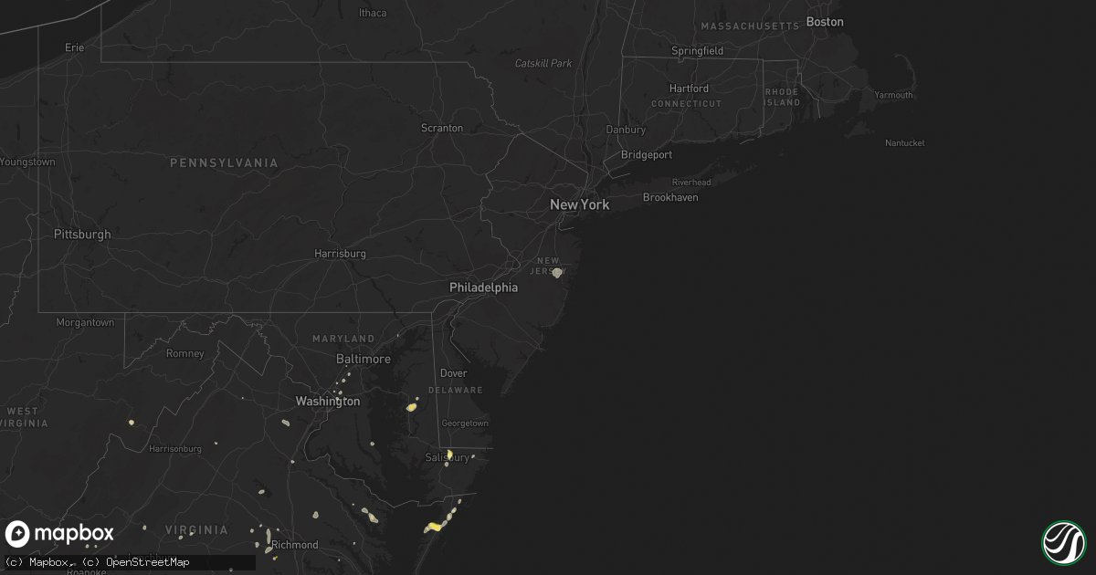
Hail Map in New Jersey on August 5, 2022
Get this storm
August 5 map
$229
one time, instant access
Download today. No call, no setup
Keep the $229
Bought the map and want the full workflow? Apply the entire $229 to a subscription within 7 days. None of it is wasted.
Every map, not just this one
This buys you this map. Subscription and you get every map we run, in the markets you choose from a few cities to whole states to nationwide. Plus real-time alerts the moment a storm fires.
Contact data
Name, contact info, occupancy, even credit band for addresses in the footprint. You go from where it hit to who to call.
Become the source they trust
Unlimited branding weather history reports on demand. You already have the documented answer ready for the property owner, and you are the one who showed up with it.
Property data and RoofTrace estimates
Pull up any address you have got, its value and the exact code rules for that jurisdiction, straight from One Click Code. Then RoofTrace estimates the squares, pitch, and roof value, priced the way you price.
Storm reports in New Jersey
New Jersey
| Date | Description |
|---|---|
| 08/05/20226:09 PM CDT | Reports of trees down on wires on lakewood-farmingdale road. Time estimated via radar. |
| 08/05/20225:36 PM CDT | Trained spotter reports a large tree down. Picture provided via social media. Time estimated via radar. |
| 08/05/20222:06 AM CDT | At 705 PM EDT, a cluster of severe thunderstorms were located over Browns Mills and across portions of northern Ocean County, moving northeast at 15 mph. HAZARD...60 mph wind gusts and quarter size hail. SOURCE...Radar indicated. IMPACT...Minor damage to vehicles is possible. Wind damage to roofs, siding, trees, and power lines is possible. Locations impacted include... Toms River, Lakewood, Jackson, Lakehurst, Pemberton, Wrightstown, Cassville, Vista Center, Leisure Village, Woodruff, Six Flags Theme Park, Cedar Glen West, Browns Mills, Jacksons Mills, Leisure Village East, Leisure Village West-Pine Lake Park, Country Lake Estates, Leisure Knoll, New Egypt and Fort Dix.This includes the following highways... Interstate 195 in New Jersey between mile markers 17 and 26. Garden State Parkway between mile markers 88 and 91. |
| 08/05/20221:26 AM CDT | At 625 PM EDT, a severe thunderstorm was located over Lakewood, or 9 miles north of Toms River, moving northeast at 5 mph. Another storm was located over Joint Base, also moving northeast at 5 mph. HAZARD...60 mph wind gusts and quarter size hail. SOURCE...Radar indicated. IMPACT...Minor damage to vehicles is possible. Wind damage to roofs, siding, trees, and power lines is possible. Locations impacted include... Toms River, Lakewood, Jackson, Howell, Lakehurst, Cassville, Adelphia, Vista Center, Allenwood, Ramtown, Cedar Glen West, Freewood Acres, Jacksons Mills, West Freehold, Brielle and Leisure Knoll.This includes the following highways... Interstate 195 in New Jersey between mile markers 22 and 32. Garden State Parkway between mile markers 91 and 96. |
All States Impacted by Hail Map on August 5, 2022
Cities Impacted by Hail Map on August 5, 2022
- Leonard, MN
- Milnor, ND
- Moorhead, MN
- Fargo, ND
- Dilworth, MN
- West Fargo, ND
- Hyattsville, MD
- Capitol Heights, MD
- Washington, DC
- New Church, VA
- Wallops Island, VA
- Horace, ND
- Sweetwater, TN
- Madisonville, TN
- Gladstone, VA
- Bellingham, MN
- Cordova, MD
- Easton, MD
- Bowie, MD
- Frankford, DE
- Dagsboro, DE
- Holabird, SD
- Farnham, VA
- Wanblee, SD
- Long Valley, SD
- Morris, MN
- Keokee, VA
- Holmes Mill, KY
- Dell Rapids, SD
- Trent, SD
- Claremont, SD
- Lanexa, VA
- Aberdeen, MD
- Maidens, VA
- Littlefork, MN
- Big Falls, MN
- Dracut, MA
- Tyngsboro, MA
- Syria, VA
- Bedford, VA
- Waubay, SD
- Mahnomen, MN
- Twin Valley, MN
- Waubun, MN
- Lancaster, VA
- Fincastle, VA
- Laurel, MD
- Glyndon, MN
- Jasper, GA
- Bloxom, VA
- Parksley, VA
- Saint Leonard, MD
- Port Republic, MD
- International Falls, MN
- Raton, NM
- Wapakoneta, OH
- Powhatan, VA
- Danville, VA
- Dry Fork, VA
- Fairmount, GA
- Felton, MN
- Amherst, MA
- Temperanceville, VA
- Assawoman, VA
- Alexandria, MN
- Farwell, MN
- Shevlin, MN
- Puposky, MN
- Redlake, MN
- Northome, MN
- Mizpah, MN
- Cando, ND
- Laurel, DE
- Georgetown, DE
- Millsboro, DE
- Ipswich, SD
- Roscoe, SD
- Lima, OH
- Conde, SD
- Kensington, MN
- Morristown, TN
- Beltsville, MD
- Patagonia, AZ
- Burkeville, VA
- Jetersville, VA
- Berlin, MD
- Aberdeen, SD
- Lake Benton, MN
- Swords Creek, VA
- Riverdale, MD
- Lanham, MD
- Twentynine Palms, CA
- Clearbrook, MN
- Ponemah, MN
- Redby, MN
- Dalton, GA
- Blakeslee, PA
- Faulkton, SD
- Washburn, TN
- Del Rio, TN
- Corona, SD
- Twin Brooks, SD
- Wilmot, SD
- Marvin, SD
- Milbank, SD
- Summit, SD
- Valentine, NE
- Englewood, FL
- Groton, SD
- Sabin, MN
- Columbia, MD
- Ellicott City, MD
- Ulen, MN
- Hawley, MN
- Clara City, MN
- Colman, SD
- Pelham, NC
- Providence, NC
- Sisseton, SD
- Duff, TN
- La Follette, TN
- Annapolis Junction, MD
- Jessup, MD
- Britton, SD
- Alpharetta, GA
- Big Piney, WY
- Langford, SD
- Madison, MN
- Johnson City, TN
- Harrold, SD
- Chesterfield, VA
- Midlothian, VA
- Waterford, OH
- Denton, MD
- Hillsboro, MD
- Queen Anne, MD
- Summerfield, NC
- Stokesdale, NC
- Madison, NC
- Hull, MA
- Tabiona, UT
- Hanna, UT
- Rowe, VA
- Oakwood, VA
- Martinsville, VA
- Clayton, GA
- Wood, SD
- Okreek, SD
- Mission, SD
- Parmelee, SD
- Presho, SD
- Vivian, SD
- Witten, SD
- Martin, SD
- White River, SD
- Norris, SD
- Murdo, SD
- Winner, SD
- Draper, SD
- Saint Francis, SD
- Rosebud, SD
- Ideal, SD
- Amherst, VA
- Vesuvius, VA
- Columbia, SD
- Delmar, MD
- Salisbury, MD
- Pocono Lake, PA
- Dryden, VA
- Pennington Gap, VA
- Tuthill, SD
- Watertown, SD
- Ortley, SD
- Big Stone City, SD
- Labolt, SD
- Bisbee, ND
- Franklin, WV
- Flandreau, SD
- Palestine, WV
- Dahlonega, GA
- Nokesville, VA
- Bristow, VA
- Clark, SD
- Ivanhoe, MN
- Ennice, NC
- Landrum, SC
- Elkton, SD
- Buckingham, VA
- Bristol, SD
- Webster, SD
- Sacred Heart, MN
- Bradley, SD
- Linden, VA
- Jonesborough, TN
- Henry, SD
- Hazel, SD
- Pierre, SD
- Blunt, SD
- Bath, SD
- Pierpont, SD
- Orient, SD
- Onaka, SD
- Mansfield, SD
- Northville, SD
- Ashton, SD
- Lebanon, SD
- Stratford, SD
- Mellette, SD
- Onida, SD
- Seneca, SD
- Roslyn, SD
- Andover, SD
- Highmore, SD
- Warner, SD
- Cresbard, SD
- Walcott, ND
- Wyndmere, ND
- Mcleod, ND
- Glenwood, MN
- Lowry, MN
- Villard, MN
- Murphy, NC
- Fredericksburg, VA
- Amherstdale, WV
- Lakewood, NJ
- Jackson, NJ
- Toms River, NJ
- Manchester Township, NJ
- Delbarton, WV
- Cattaraugus, NY
- Randolph, NY
- Egan, SD
- Manakin Sabot, VA
- Painter, VA
- Hacksneck, VA
- Onancock, VA
- Accomac, VA
- Onley, VA
- Melfa, VA
- Greenbush, VA
- Aylett, VA
- Windsor, OH
- Middlefield, OH
- Ball Ground, GA
- Raven, VA
- Honaker, VA
- Knoxville, TN
- Freeport, FL
- Punta Gorda, FL
- Florence, SD
- Eagle Bend, MN
- Kingston, GA
- Bokeelia, FL
- Las Vegas, NM
- Garita, NM
- Spencer, WV
- Stoneville, NC
- Eden, NC
- Ridgeway, VA
- Warsaw, VA
- Watson, MN
- Benson, MN
- Montevideo, MN
- Milan, MN
- Danvers, MN
- Port Charlotte, FL
- Dawsonville, GA
- Hallwood, VA
- Safety Harbor, FL
- Clearwater, FL
- Dunedin, FL
- Wallace, SD
- Marietta, GA
- Kennesaw, GA
- Kilgore, NE
- Bradenton, FL
- Parrish, FL
- Ellenton, FL
- Mineral, VA
- Old Town, FL
- Arcadia, FL
- Buchanan, VA
- Woodstock, GA
- Cedar Key, FL
- Temple, GA
- Crookston, NE
- Fort Pierre, SD
- Huntsville, TX
- Bedias, TX
- Saint Petersburg, FL
- Largo, FL
- Seminole, FL
- Indian Rocks Beach, FL
- Dallas, GA
- Rockmart, GA
- Roswell, GA
- Waskish, MN
- Salem, VA
- Fruitland, MD
- Eden, MD
- Shacklefords, VA
- Palmetto, FL
- Canton, GA
- Walker, WV
- Petroleum, WV
- Cleveland, TN
- Cohutta, GA
- Welch, WV
- Paynesville, WV
- Cartersville, GA
- Sonoita, AZ
- Calhoun, GA
- Brookneal, VA
- Kelliher, MN
- Moseley, VA
- Bybee, TN
- Russellville, TN
- Newport, TN
- Mohawk, TN
- Atlanta, GA
- Appleton, MN
- Hosford, FL
- Belview, MN
- Redwood Falls, MN
- Glen Allen, VA
- Tyner, KY
- Chatsworth, GA
- Maynardville, TN
- Luttrell, TN
- Powder Springs, TN
- Bomont, WV
- Frederick, SD
- Houghton, SD
- Barnard, SD
- Westport, SD
- Lake City, SD
- Veblen, SD
- Cogswell, ND
- Forman, ND
- Gwinner, ND
- Loman, MN
- Parsonsburg, MD


