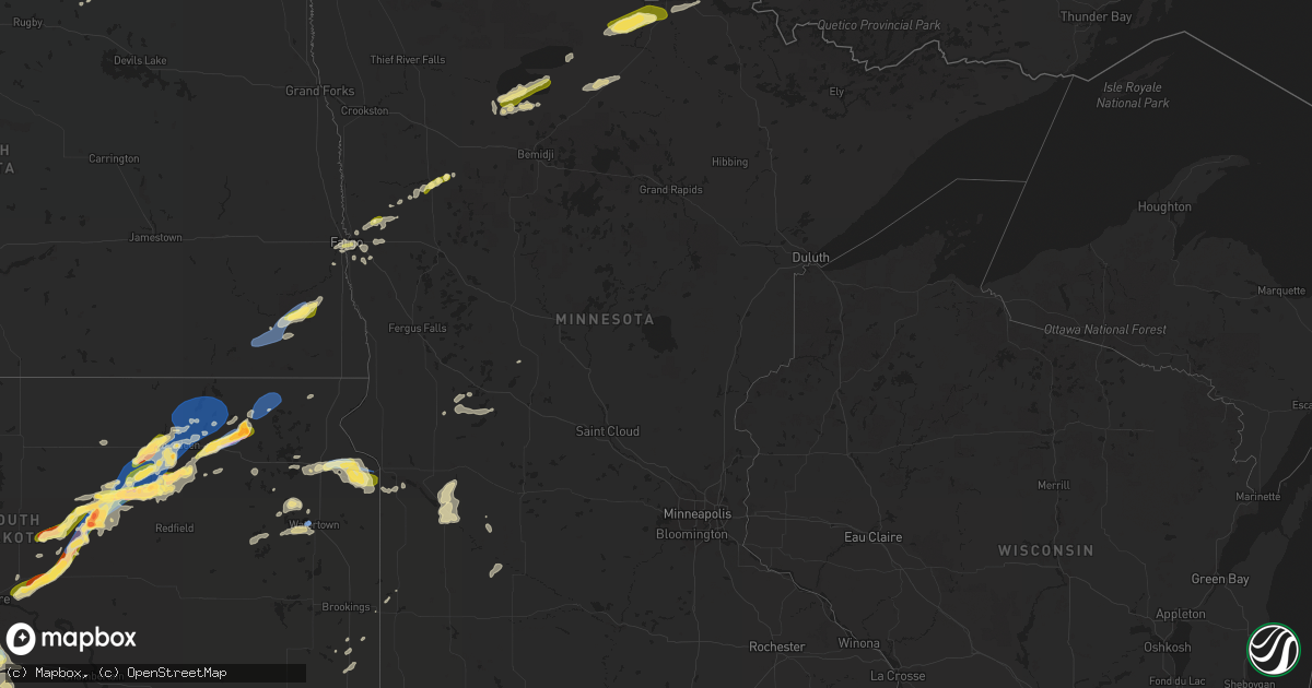
Hail Map in Minnesota on August 5, 2022
Get this storm
August 5 map
$229
one time, instant access
Download today. No call, no setup
Keep the $229
Bought the map and want the full workflow? Apply the entire $229 to a subscription within 7 days. None of it is wasted.
Every map, not just this one
This buys you this map. Subscription and you get every map we run, in the markets you choose from a few cities to whole states to nationwide. Plus real-time alerts the moment a storm fires.
Contact data
Name, contact info, occupancy, even credit band for addresses in the footprint. You go from where it hit to who to call.
Become the source they trust
Unlimited branding weather history reports on demand. You already have the documented answer ready for the property owner, and you are the one who showed up with it.
Property data and RoofTrace estimates
Pull up any address you have got, its value and the exact code rules for that jurisdiction, straight from One Click Code. Then RoofTrace estimates the squares, pitch, and roof value, priced the way you price.
Storm reports in Minnesota
Minnesota
| Date | Description |
|---|---|
| 08/05/20223:54 AM CDT | At 853 PM CDT, a severe thunderstorm was located near Debs, or 22 miles northwest of Bemidji, moving east at 55 mph. HAZARD...60 mph wind gusts and quarter size hail. SOURCE...Radar indicated. IMPACT...Hail damage to vehicles is expected. Expect wind damage to roofs, siding, and trees. This severe thunderstorm will be near... Little Rock around 855 PM CDT. Island Lake in Beltrami County and Red Lake around 900 PM CDT. Nebish and Redby around 905 PM CDT.Other locations in the path of this severe thunderstorm includeBlackduck, Shooks, Funkley and Kelliher. |
| 08/05/20223:41 AM CDT | At 841 PM CDT, a severe thunderstorm was located near Rollag, or 16 miles west of Detroit Lakes, moving east at 40 mph. HAZARD...60 mph wind gusts and quarter size hail. SOURCE...Radar indicated. IMPACT...Hail damage to vehicles is expected. Expect wind damage to roofs, siding, and trees. This severe thunderstorm will be near... Lake Park around 845 PM CDT. Cormorant around 850 PM CDT. Shoreham around 900 PM CDT.Other locations in the path of this severe thunderstorm includeDetroit Lakes, Frazee and Rochert. |
| 08/05/20223:37 AM CDT | At 837 PM CDT, a severe thunderstorm was located over eastern Lower Red Lake, or 34 miles north of Bemidji, moving northeast at 50 mph. HAZARD...60 mph wind gusts and half dollar size hail. SOURCE...Radar indicated. IMPACT...Hail damage to vehicles is expected. Expect wind damage to roofs, siding, and trees. This severe thunderstorm will be near... Saum around 840 PM CDT. Shotley around 845 PM CDT. Otto around 850 PM CDT. Waskish around 855 PM CDT. |
| 08/05/20223:19 AM CDT | At 818 PM CDT, a severe thunderstorm was located over western White Earth Nation, or 31 miles north of Detroit Lakes, moving northeast at 45 mph. HAZARD...60 mph wind gusts and half dollar size hail. SOURCE...Radar indicated. IMPACT...Hail damage to vehicles is expected. Expect wind damage to roofs, siding, and trees. This severe thunderstorm will be near... Beaulieu around 830 PM CDT. Naytahwaush around 835 PM CDT.Other locations in the path of this severe thunderstorm includeMahkonce, Island Lake in Mahnomen County, Roy Lake, Pine Bend, LowerRice Lake, Rice Lake and Ebro. |
| 08/05/20223:08 AM CDT | At 807 PM CDT, a severe thunderstorm was located over southern Red Lake Nation, or 28 miles northwest of Bemidji, moving east at 45 mph. HAZARD...60 mph wind gusts and quarter size hail. SOURCE...Radar indicated. IMPACT...Hail damage to vehicles is expected. Expect wind damage to roofs, siding, and trees. This severe thunderstorm will be near... Lower Red Lake around 810 PM CDT. Little Rock and Island Lake in Beltrami County around 815 PM CDT. Red Lake around 820 PM CDT. Redby around 825 PM CDT.Other locations in the path of this severe thunderstorm includePonemah. |
| 08/05/20223:01 AM CDT | At 801 PM CDT, a severe thunderstorm was located over Syre, or 29 miles northwest of Detroit Lakes, moving northeast at 30 mph. HAZARD...60 mph wind gusts and half dollar size hail. SOURCE...Radar indicated. IMPACT...Hail damage to vehicles is expected. Expect wind damage to roofs, siding, and trees. This severe thunderstorm will be near... Flom around 805 PM CDT. Faith around 820 PM CDT.Other locations in the path of this severe thunderstorm includeWaubun. |
| 08/05/20222:39 AM CDT | At 739 PM CDT, a severe thunderstorm was located near Averill, or 18 miles northeast of Fargo, moving northeast at 30 mph. HAZARD...60 mph wind gusts and quarter size hail. SOURCE...Radar indicated. IMPACT...Hail damage to vehicles is expected. Expect wind damage to roofs, siding, and trees. Locations impacted include... Ulen. |
| 08/04/20229:03 PM CDT | Hail across highway 89 just south of the casino. |
| 08/04/20228:34 PM CDT | At 133 PM CDT, a severe thunderstorm was located 10 miles southwest of Loman, or 27 miles southwest of International Falls, moving east at 45 mph. HAZARD...Ping pong ball size hail and 60 mph wind gusts. SOURCE...Radar indicated. IMPACT...People and animals outdoors will be injured. Expect hail damage to roofs, siding, windows, and vehicles. Expect wind damage to roofs, siding, and trees. This severe thunderstorm will be near... Loman around 145 PM CDT.Other locations in the path of this severe thunderstorm includeLittlefork and Pelland. |
| 08/04/20228:25 PM CDT | A number of 4 to 6 inch branches broken down. Wind gusted for about 5 minutes. |
| 08/04/20228:18 PM CDT | Quarter size hail covering the ground. Very heavy rain. |
| 08/04/20228:15 PM CDT | A few quarter sized hail and very strong winds. |
| 08/04/20227:55 PM CDT | Brief burst of hail. |
| 08/04/20227:40 PM CDT | Nickel to quarter size hail on and on for 2 to 3 minutes... Until 743 pm cdt. |
| 08/04/20227:35 PM CDT | Wind gusts to 60 mph along with half inch hail. Winds gusted until 738 pm cdt |
| 08/04/20227:15 PM CDT | Hail near hwy 10 at east edge of moorhead. |
| 08/04/20227:15 PM CDT | A local report indicates 1.00 inch wind near 2 E MOORHEAD |
All States Impacted by Hail Map on August 5, 2022
Cities Impacted by Hail Map on August 5, 2022
- Leonard, MN
- Milnor, ND
- Moorhead, MN
- Fargo, ND
- Dilworth, MN
- West Fargo, ND
- Hyattsville, MD
- Capitol Heights, MD
- Washington, DC
- New Church, VA
- Wallops Island, VA
- Horace, ND
- Sweetwater, TN
- Madisonville, TN
- Gladstone, VA
- Bellingham, MN
- Cordova, MD
- Easton, MD
- Bowie, MD
- Frankford, DE
- Dagsboro, DE
- Holabird, SD
- Farnham, VA
- Wanblee, SD
- Long Valley, SD
- Morris, MN
- Keokee, VA
- Holmes Mill, KY
- Dell Rapids, SD
- Trent, SD
- Claremont, SD
- Lanexa, VA
- Aberdeen, MD
- Maidens, VA
- Littlefork, MN
- Big Falls, MN
- Dracut, MA
- Tyngsboro, MA
- Syria, VA
- Bedford, VA
- Waubay, SD
- Mahnomen, MN
- Twin Valley, MN
- Waubun, MN
- Lancaster, VA
- Fincastle, VA
- Laurel, MD
- Glyndon, MN
- Jasper, GA
- Bloxom, VA
- Parksley, VA
- Saint Leonard, MD
- Port Republic, MD
- International Falls, MN
- Raton, NM
- Wapakoneta, OH
- Powhatan, VA
- Danville, VA
- Dry Fork, VA
- Fairmount, GA
- Felton, MN
- Amherst, MA
- Temperanceville, VA
- Assawoman, VA
- Alexandria, MN
- Farwell, MN
- Shevlin, MN
- Puposky, MN
- Redlake, MN
- Northome, MN
- Mizpah, MN
- Cando, ND
- Laurel, DE
- Georgetown, DE
- Millsboro, DE
- Ipswich, SD
- Roscoe, SD
- Lima, OH
- Conde, SD
- Kensington, MN
- Morristown, TN
- Beltsville, MD
- Patagonia, AZ
- Burkeville, VA
- Jetersville, VA
- Berlin, MD
- Aberdeen, SD
- Lake Benton, MN
- Swords Creek, VA
- Riverdale, MD
- Lanham, MD
- Twentynine Palms, CA
- Clearbrook, MN
- Ponemah, MN
- Redby, MN
- Dalton, GA
- Blakeslee, PA
- Faulkton, SD
- Washburn, TN
- Del Rio, TN
- Corona, SD
- Twin Brooks, SD
- Wilmot, SD
- Marvin, SD
- Milbank, SD
- Summit, SD
- Valentine, NE
- Englewood, FL
- Groton, SD
- Sabin, MN
- Columbia, MD
- Ellicott City, MD
- Ulen, MN
- Hawley, MN
- Clara City, MN
- Colman, SD
- Pelham, NC
- Providence, NC
- Sisseton, SD
- Duff, TN
- La Follette, TN
- Annapolis Junction, MD
- Jessup, MD
- Britton, SD
- Alpharetta, GA
- Big Piney, WY
- Langford, SD
- Madison, MN
- Johnson City, TN
- Harrold, SD
- Chesterfield, VA
- Midlothian, VA
- Waterford, OH
- Denton, MD
- Hillsboro, MD
- Queen Anne, MD
- Summerfield, NC
- Stokesdale, NC
- Madison, NC
- Hull, MA
- Tabiona, UT
- Hanna, UT
- Rowe, VA
- Oakwood, VA
- Martinsville, VA
- Clayton, GA
- Wood, SD
- Okreek, SD
- Mission, SD
- Parmelee, SD
- Presho, SD
- Vivian, SD
- Witten, SD
- Martin, SD
- White River, SD
- Norris, SD
- Murdo, SD
- Winner, SD
- Draper, SD
- Saint Francis, SD
- Rosebud, SD
- Ideal, SD
- Amherst, VA
- Vesuvius, VA
- Columbia, SD
- Delmar, MD
- Salisbury, MD
- Pocono Lake, PA
- Dryden, VA
- Pennington Gap, VA
- Tuthill, SD
- Watertown, SD
- Ortley, SD
- Big Stone City, SD
- Labolt, SD
- Bisbee, ND
- Franklin, WV
- Flandreau, SD
- Palestine, WV
- Dahlonega, GA
- Nokesville, VA
- Bristow, VA
- Clark, SD
- Ivanhoe, MN
- Ennice, NC
- Landrum, SC
- Elkton, SD
- Buckingham, VA
- Bristol, SD
- Webster, SD
- Sacred Heart, MN
- Bradley, SD
- Linden, VA
- Jonesborough, TN
- Henry, SD
- Hazel, SD
- Pierre, SD
- Blunt, SD
- Bath, SD
- Pierpont, SD
- Orient, SD
- Onaka, SD
- Mansfield, SD
- Northville, SD
- Ashton, SD
- Lebanon, SD
- Stratford, SD
- Mellette, SD
- Onida, SD
- Seneca, SD
- Roslyn, SD
- Andover, SD
- Highmore, SD
- Warner, SD
- Cresbard, SD
- Walcott, ND
- Wyndmere, ND
- Mcleod, ND
- Glenwood, MN
- Lowry, MN
- Villard, MN
- Murphy, NC
- Fredericksburg, VA
- Amherstdale, WV
- Lakewood, NJ
- Jackson, NJ
- Toms River, NJ
- Manchester Township, NJ
- Delbarton, WV
- Cattaraugus, NY
- Randolph, NY
- Egan, SD
- Manakin Sabot, VA
- Painter, VA
- Hacksneck, VA
- Onancock, VA
- Accomac, VA
- Onley, VA
- Melfa, VA
- Greenbush, VA
- Aylett, VA
- Windsor, OH
- Middlefield, OH
- Ball Ground, GA
- Raven, VA
- Honaker, VA
- Knoxville, TN
- Freeport, FL
- Punta Gorda, FL
- Florence, SD
- Eagle Bend, MN
- Kingston, GA
- Bokeelia, FL
- Las Vegas, NM
- Garita, NM
- Spencer, WV
- Stoneville, NC
- Eden, NC
- Ridgeway, VA
- Warsaw, VA
- Watson, MN
- Benson, MN
- Montevideo, MN
- Milan, MN
- Danvers, MN
- Port Charlotte, FL
- Dawsonville, GA
- Hallwood, VA
- Safety Harbor, FL
- Clearwater, FL
- Dunedin, FL
- Wallace, SD
- Marietta, GA
- Kennesaw, GA
- Kilgore, NE
- Bradenton, FL
- Parrish, FL
- Ellenton, FL
- Mineral, VA
- Old Town, FL
- Arcadia, FL
- Buchanan, VA
- Woodstock, GA
- Cedar Key, FL
- Temple, GA
- Crookston, NE
- Fort Pierre, SD
- Huntsville, TX
- Bedias, TX
- Saint Petersburg, FL
- Largo, FL
- Seminole, FL
- Indian Rocks Beach, FL
- Dallas, GA
- Rockmart, GA
- Roswell, GA
- Waskish, MN
- Salem, VA
- Fruitland, MD
- Eden, MD
- Shacklefords, VA
- Palmetto, FL
- Canton, GA
- Walker, WV
- Petroleum, WV
- Cleveland, TN
- Cohutta, GA
- Welch, WV
- Paynesville, WV
- Cartersville, GA
- Sonoita, AZ
- Calhoun, GA
- Brookneal, VA
- Kelliher, MN
- Moseley, VA
- Bybee, TN
- Russellville, TN
- Newport, TN
- Mohawk, TN
- Atlanta, GA
- Appleton, MN
- Hosford, FL
- Belview, MN
- Redwood Falls, MN
- Glen Allen, VA
- Tyner, KY
- Chatsworth, GA
- Maynardville, TN
- Luttrell, TN
- Powder Springs, TN
- Bomont, WV
- Frederick, SD
- Houghton, SD
- Barnard, SD
- Westport, SD
- Lake City, SD
- Veblen, SD
- Cogswell, ND
- Forman, ND
- Gwinner, ND
- Loman, MN
- Parsonsburg, MD


