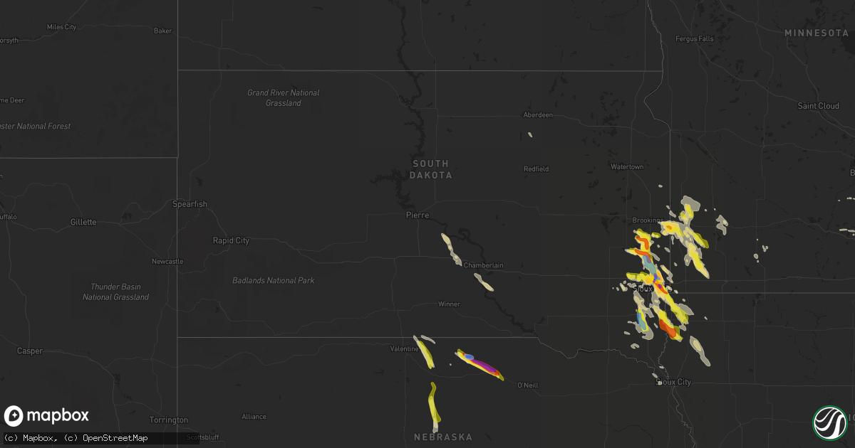
Hail Map in South Dakota on August 5, 2021
Get this storm
August 5 map
$229
one time, instant access
Download today. No call, no setup
Keep the $229
Bought the map and want the full workflow? Apply the entire $229 to a subscription within 7 days. None of it is wasted.
Every map, not just this one
This buys you this map. Subscription and you get every map we run, in the markets you choose from a few cities to whole states to nationwide. Plus real-time alerts the moment a storm fires.
Contact data
Name, contact info, occupancy, even credit band for addresses in the footprint. You go from where it hit to who to call.
Become the source they trust
Unlimited branding weather history reports on demand. You already have the documented answer ready for the property owner, and you are the one who showed up with it.
Property data and RoofTrace estimates
Pull up any address you have got, its value and the exact code rules for that jurisdiction, straight from One Click Code. Then RoofTrace estimates the squares, pitch, and roof value, priced the way you price.
Storm reports in South Dakota
South Dakota
| Date | Description |
|---|---|
| 08/05/20216:40 PM CDT | A local report indicates 60 MPH wind near 12 E OELRICHS |
| 08/05/20215:10 PM CDT | A local report indicates 66 MPH wind near 10 W EDGEMONT |
| 08/05/20214:31 AM CDT | At 930 PM CDT, a severe thunderstorm was located near Larchwood, or 9 miles northeast of Canton, moving southeast at 35 mph. HAZARD...Ping pong ball size hail and 60 mph wind gusts. SOURCE...Radar indicated. IMPACT...People and animals outdoors will be injured. Expect hail damage to roofs, siding, windows, and vehicles. Expect wind damage to roofs, siding, and trees. This severe thunderstorm will be near... Inwood around 940 PM CDT. Alvord around 945 PM CDT.Other locations in the path of this severe thunderstorm include Doon,Rock Valley and Hull. |
| 08/05/20214:04 AM CDT | At 904 PM CDT, a severe thunderstorm was located over Humboldt, or 7 miles northeast of Lake Vermillion State Recreation Area, moving southeast at 15 mph. HAZARD...Half dollar size hail. SOURCE...Radar indicated. IMPACT...Damage to vehicles is expected.Other locations in the path of this severe thunderstorm includeHartford and Wall Lake.PRECAUTIONARY/PREPAREDNESS ACTIONS...For your protection move to an interior room on the lowest floor of abuilding.Large hail and damaging winds and continuous cloud to groundlightning is occurring with this storm. Move indoors immediately.Lightning is one of nature's leading killers. Remember, if you canhear thunder, you are close enough to be struck by lightning. |
| 08/05/20212:58 AM CDT | At 757 PM CDT, a severe thunderstorm was located over Wentworth, or 9 miles east of Madison, moving southeast at 20 mph. HAZARD...Ping pong ball size hail. SOURCE...Radar indicated. IMPACT...People and animals outdoors will be injured. Expect damage to roofs, siding, windows, and vehicles. This severe thunderstorm will be near... Colman and Chester around 810 PM CDT.Other locations in the path of this severe thunderstorm include DellRapids and Trent. |
| 08/05/20212:28 AM CDT | At 728 PM CDT, a severe thunderstorm was located over Elkton, or 16 miles north of Pipestone, moving southeast at 25 mph. HAZARD...Quarter size hail. SOURCE...Trained weather spotters. IMPACT...Damage to vehicles is expected. This severe thunderstorm will remain over mainly rural areas of southwestern Lincoln, northwestern Pipestone, northeastern Moody and southeastern Brookings Counties. |
| 08/05/20212:00 AM CDT | At 659 PM CDT, a severe thunderstorm was located near Nunda, or 10 miles southwest of Brookings, moving southeast at 25 mph. HAZARD...Half dollar size hail. SOURCE...Radar indicated. IMPACT...Damage to vehicles is expected. Locations impacted include... Flandreau and Egan. |
| 08/05/20211:06 AM CDT | Report via social media. Time estimated via radar. |
| 08/04/202111:49 PM CDT | Video via social media. |
| 08/04/202111:23 PM CDT | At 422 PM CDT, severe thunderstorms were located along a line extending from near Norden to 13 miles southeast of Littleburg, moving southeast at 25 mph. HAZARD...60 mph wind gusts and quarter size hail. SOURCE...Radar indicated. IMPACT...Hail damage to vehicles is expected. Expect wind damage to roofs, siding, and trees. Locations impacted include... Johnstown, Norden, Keller Park State Recreation Area, Smith Falls State Park, Bobcat State Wildlife Management Area, Pine Glen State Wildlife Refuge, Antelope Peak, Meadville, North River Trail, Sparks and Thomas Creek State Wildlife Management Area.This includes the following highways... Highway 183 between mile markers 198 and 212. Highway 20 between mile markers 224 and 238. Highway 12 between mile markers 13 and 50. |
| 08/04/202110:45 PM CDT | Tree reported knocked down. |
| 08/04/202110:20 PM CDT | Structural damage to garage with back wall blown out. Pictures via social media. Time estimated via radar. |
| 08/04/20219:13 PM CDT | Several large tree branches down at the mary jo wegner arboretum... Some as large as a foot in diameter. Time estimated via radar and nearby ground observations. |
| 08/04/20219:10 PM CDT | A local report indicates 2.00 inch wind near 4 WNW ROWENA |
| 08/04/20219:08 PM CDT | A local report indicates 1.00 inch wind near 4 WNW ROWENA |
| 08/04/20219:04 PM CDT | Report via social media. |
| 08/04/20219:00 PM CDT | Via social media picture. |
| 08/04/20218:59 PM CDT | Several 8 year old pine trees uprooted. Time estimated by radar. Via social media picture. |
| 08/04/20218:58 PM CDT | Delayed report. Portion of deck overhang and roof blown off. Time estimated via radar. |
| 08/04/20218:50 PM CDT | Via picture on social media. |
| 08/04/20218:50 PM CDT | Report via social media of damage to a building. |
| 08/04/20218:35 PM CDT | Report via social media. |
| 08/04/20218:24 PM CDT | Via social media. |
| 08/04/20218:00 PM CDT | Report via social media with photos. |
| 08/04/20218:00 PM CDT | A local report indicates 1.75 inch wind near 2 E WENTWORTH |
| 08/04/20217:53 PM CDT | Report via social media. |
| 08/04/20217:43 PM CDT | A local report indicates 1.50 inch wind near 8 N COLMAN |
| 08/04/20217:35 PM CDT | A local report indicates 1.00 inch wind near ELKTON |
| 08/04/20217:29 PM CDT | Report via social media with a photo. |
| 08/04/20217:26 PM CDT | A local report indicates 1.00 inch wind near ELKTON |
| 08/04/20217:25 PM CDT | Report via social media with photo. |
| 08/04/20217:15 PM CDT | A local report indicates 1.00 inch wind near 9 N COLMAN |
All States Impacted by Hail Map on August 5, 2021
Cities Impacted by Hail Map on August 5, 2021
- Custer City, OK
- Taloga, OK
- Baltic, SD
- Wentworth, SD
- Crooks, SD
- Larchwood, IA
- Rock Rapids, IA
- Renner, SD
- Colton, SD
- Canton, SD
- Fairview, SD
- Ireton, IA
- Hartford, SD
- Garretson, SD
- Worthing, SD
- Chester, SD
- Flandreau, SD
- Brandon, SD
- Montrose, SD
- Rock Valley, IA
- Dell Rapids, SD
- Hills, MN
- Hudson, SD
- Trent, SD
- Sioux Falls, SD
- Madison, SD
- Valley Springs, SD
- Humboldt, SD
- Rutland, SD
- Hull, IA
- Volga, SD
- Sioux Center, IA
- Inwood, IA
- Alcester, SD
- Alvord, IA
- Nunda, SD
- Doon, IA
- Colman, SD
- Harrisburg, SD
- Egan, SD
- Hawarden, IA
- Sparks, NE
- Valentine, NE
- Hastings, MN
- Rueter, MO
- Kissee Mills, MO
- Ruthton, MN
- Holland, MN
- Sells, AZ
- Woodstock, MN
- Centerville, SD
- Lennox, SD
- Davis, SD
- Beresford, SD
- Cascade, ID
- Donnelly, ID
- Lake Benton, MN
- Aurora, SD
- Pipestone, MN
- Elkton, SD
- Lower Brule, SD
- Kennebec, SD
- Springview, NE
- Newport, NE
- Bassett, NE
- Chancellor, SD
- Council Grove, KS
- Madison Lake, MN
- Purdum, NE
- Amherst, NE
- Pleasanton, NE
- Miller, NE
- Mason City, NE
- Johnstown, NE
- Stuart, NE
- Garrison, MT
- Ainsworth, NE
- Mission, SD
- Haines, OR
- Cambridge, ID
- Midvale, ID
- Moran, WY
- Cottage Grove, MN
- Lindstrom, MN
- Center City, MN
- Edgerton, MN
- Kenneth, MN
- Adrian, MN
- Lismore, MN
- Wilmont, MN
- Chandler, MN
- Leota, MN
- Le Mars, IA
- Orange City, IA
- Alton, IA
- Remsen, IA
- Waseca, MN
- Maurice, IA
- Kingsley, IA
- Marcus, IA
- Pilot Rock, OR
- Afton, MN
- River Falls, WI
- Arco, MN
- Tyler, MN
- Ivanhoe, MN
- Reliance, SD
- Elgin, OR
- Elysian, MN
- Janesville, MN
- Waterville, MN
- Clinton, OK
- Butler, OK
- Pine City, MN
- Elk Point, SD
- Union, OR
- Minneota, MN
- Hardwick, MN
- Lynd, MN
- Rushmore, MN
- Porter, MN
- Lake Wilson, MN
- Allen, KS
- Edinburg, TX
- Henderson, MN
- New Prague, MN
- Isabella, OK
- Okeene, OK
- Luverne, MN
- Jasper, MN
- Beaver Creek, MN
- Nogales, AZ
- Grasston, MN
- Brook Park, MN
- Prairie City, OR
- La Grande, OR
- Moore, ID
- Howe, ID
- Canistota, SD
- Parker, SD
- Saint Paul, MN
- Wallowa, OR
- Hudson, WI
- Roberts, WI
- Sumpter, OR
- Baker City, OR
- Jeffers, MN
- Tracy, MN
- Wakonda, SD
- Irene, SD
- Vermillion, SD
- Volin, SD
- Jackson, NE
- Tea, SD
- Viborg, SD
- Saint Paul Park, MN
- Chisago City, MN
- Brandt, SD
- Chamberlain, SD
- Platte, SD
- Mountain Lake, MN
- Somerset, WI
- Houlton, WI
- Hendricks, MN
- White, SD
- Admire, KS
- Garvin, MN
- Rio Grande City, TX
- New Richmond, WI
- Lostine, OR
- Andover, MN
- Centuria, WI
- Stillwater, MN
- Northfield, MN
- Webster, MN
- Lonsdale, MN
- Marshall, MN
- Belle Plaine, MN
- Windom, MN
- Sheldon, IA
- Taneyville, MO
- Shafer, MN
- Taylors Falls, MN
- New Meadows, ID
- Inver Grove Heights, MN
- Lake Elmo, MN
- Newport, MN
- Prescott, WI
- South Saint Paul, MN
- Stanchfield, MN
- Rush City, MN
- Harris, MN
- Mansfield, SD
- Ponca, NE
- Saint Croix Falls, WI
- Cushing, WI
- Hugo, MN
- Osceola, WI
- Marine On Saint Croix, MN
- Forest Lake, MN
- Circle Pines, MN
- Foss, OK
- Bingham Lake, MN
- Currie, MN
- Grantsburg, WI
- North Branch, MN
- Mills, NE
- Arapaho, OK
- Atkinson, NE
- Brookings, SD
- Balaton, MN
- Lyons, SD


