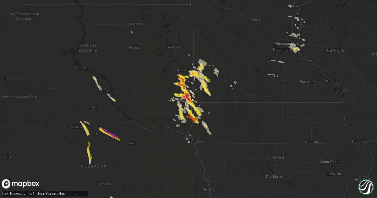
Hail Map on August 5, 2021
Get this storm
August 5 map
$229
one time, instant access
Download today. No call, no setup
Keep the $229
Bought the map and want the full workflow? Apply the entire $229 to a subscription within 7 days. None of it is wasted.
Every map, not just this one
This buys you this map. Subscription and you get every map we run, in the markets you choose from a few cities to whole states to nationwide. Plus real-time alerts the moment a storm fires.
Contact data
Name, contact info, occupancy, even credit band for addresses in the footprint. You go from where it hit to who to call.
Become the source they trust
Unlimited branding weather history reports on demand. You already have the documented answer ready for the property owner, and you are the one who showed up with it.
Property data and RoofTrace estimates
Pull up any address you have got, its value and the exact code rules for that jurisdiction, straight from One Click Code. Then RoofTrace estimates the squares, pitch, and roof value, priced the way you price.
States Impacted by Hail Map on August 5, 2021
Storm reports
Nebraska
| Date | Description |
|---|---|
| 08/05/20216:03 PM CDT | A local report indicates 1.00 inch wind near 1 SW STUART |
| 08/05/20215:45 PM CDT | A local report indicates 60 MPH wind near 19 S JOHNSTOWN |
| 08/05/20215:15 PM CDT | Wind gusts estimated at 80 mph. Several trees uprooted and broken off. A camper was rolled over and a grain bin was damaged. Power was also lost. |
| 08/05/20215:15 PM CDT | Very heavy rain with hail up to golf ball size was observed. |
| 08/05/20215:14 PM CDT | Roughly half mile of power poles snapped. Time estimated. |
| 08/05/20214:25 PM CDT | A local report indicates 1.00 inch wind near 5 S SPARKS |
| 08/05/202112:59 AM CDT | At 557 PM CDT, severe thunderstorms were located along a line extending from 18 miles south of Johnstown to 6 miles north of Elsmere to 14 miles north of Purdum, moving south at 35 mph. THESE ARE DESTRUCTIVE STORMS FOR ELSMERE AND PURDUM! HAZARD...80 mph wind gusts and ping pong ball size hail. SOURCE...Radar indicated. IMPACT...Flying debris will be dangerous to those caught without shelter. Mobile homes will be heavily damaged. Expect considerable damage to roofs, windows, and vehicles. Extensive tree damage and power outages are likely. Locations impacted include... Brewster, Dunning, Halsey, Elsmere, Purdum, Koshopah, Moon Lake, Hawley Flats, Willow Lake State Wildlife Management Area and Long Lake State Wildlife Management Area.This includes Highway 2 between mile markers 222 and 240. |
| 08/05/202112:49 AM CDT | At 548 PM CDT, a severe thunderstorm was located near Newport, or 15 miles east of Bassett, moving southeast at 40 mph. THIS IS A DESTRUCTIVE STORM APPROACHING STUART! HAZARD...Three inch hail and 70 mph wind gusts. SOURCE...Radar indicated. IMPACT...People and animals outdoors will be severely injured. Expect shattered windows, extensive damage to roofs, siding, and vehicles. Locations impacted include... O'neill, O'Neill, Atkinson, Stuart, Newport and Emmet. This includes the following highways... Highway 20 between mile markers 265 and 308. Highway 281 between mile markers 183 and 189. |
| 08/05/202112:39 AM CDT | At 539 PM CDT, a severe thunderstorm was located 12 miles southwest of Johnstown, or 18 miles southwest of Ainsworth, moving southeast at 30 mph. HAZARD...70 mph wind gusts and quarter size hail. SOURCE...Radar indicated. IMPACT...Hail damage to vehicles is expected. Expect considerable tree damage. Wind damage is also likely to mobile homes, roofs, and outbuildings. Locations impacted include... Moon Lake, Willow Lake State Wildlife Management Area and Long Lake State Wildlife Management Area. |
| 08/05/202112:13 AM CDT | At 513 PM CDT, severe thunderstorms were located along a line extending from 7 miles east of Springview to 7 miles west of Johnstown, moving southeast at 25 mph. HAZARD...Ping pong ball size hail and 60 mph wind gusts. SOURCE...Radar indicated. IMPACT...People and animals outdoors will be injured. Expect hail damage to roofs, siding, windows, and vehicles. Expect wind damage to roofs, siding, and trees. Locations impacted include... Ainsworth, Bassett, Long Pine, Newport, Johnstown, Wood Lake, Hofeld Lake, Bobcat State Wildlife Management Area, Meadville, Keller Park State Recreation Area, Thomas Creek State Wildlife Management Area, Pine Glen State Wildlife Refuge, Antelope Peak and Jones Lake.This includes the following highways... Highway 183 between mile markers 171 and 212. Highway 20 between mile markers 221 and 274. |
| 08/04/202111:40 PM CDT | At 440 PM CDT, a severe thunderstorm was located near Pleasanton, or 19 miles north of Kearney, moving southeast at 15 mph. HAZARD...60 mph wind gusts and quarter size hail. SOURCE...Radar indicated. IMPACT...Hail damage to vehicles is expected. Expect wind damage to roofs, siding, and trees. This severe thunderstorm will be near... Pleasanton around 455 PM CDT. |
Oregon
| Date | Description |
|---|---|
| 08/05/20215:00 PM CDT | 100 foot tree snapped in half due to high winds. 2.09 inches of rain with storm. |
| 08/04/202110:43 PM CDT | At 342 PM PDT, a severe thunderstorm was located near Ukiah, or 27 miles southeast of Heppner, moving north at 5 mph. HAZARD...70 mph wind gusts and penny size hail. SOURCE...Radar indicated. IMPACT...Expect considerable tree damage. Damage is likely to mobile homes, roofs, and outbuildings. Locations impacted include... Ukiah. |
Iowa
| Date | Description |
|---|---|
| 08/05/20216:40 AM CDT | At 1140 PM CDT, a severe thunderstorm was located near Crooks, or 13 miles northwest of Sioux Falls, moving east at 20 mph. HAZARD...Half dollar size hail. SOURCE...Radar indicated. IMPACT...Damage to vehicles is expected. This severe thunderstorm will be near... Crooks around 1155 PM CDT.Other locations in the path of this severe thunderstorm include SiouxFalls, Brandon, Garretson and Palisades State Park. |
| 08/05/20215:36 AM CDT | At 1035 PM CDT, a severe thunderstorm was located 8 miles northeast of Centerville, or 9 miles north of Beresford, moving southeast at 35 mph. HAZARD...60 mph wind gusts and half dollar size hail. SOURCE...Radar indicated. IMPACT...Hail damage to vehicles is expected. Expect wind damage to roofs, siding, and trees. This severe thunderstorm will be near... Beresford around 1100 PM CDT.Other locations in the path of this severe thunderstorm includeAlcester and Hawarden. |
| 08/05/20215:04 AM CDT | At 1003 PM CDT, a severe thunderstorm was located near Tea, or 11 miles southwest of Sioux Falls, moving southeast at 35 mph. HAZARD...Quarter size hail. SOURCE...Radar indicated. IMPACT...Damage to vehicles is expected. This severe thunderstorm will be near... Lennox around 1015 PM CDT.Other locations in the path of this severe thunderstorm includeWorthing. |
| 08/05/20213:57 AM CDT | At 857 PM CDT, a severe thunderstorm was located near Brandon, or near Sioux Falls, moving south at 30 mph. HAZARD...70 mph wind gusts and ping pong ball size hail. SOURCE...Radar indicated. IMPACT...People and animals outdoors will be injured. Expect hail damage to roofs, siding, windows, and vehicles. Expect considerable tree damage. Wind damage is also likely to mobile homes, roofs, and outbuildings.Other locations in the path of this severe thunderstorm include LakeAlvin State Recreation Area and Canton.PRECAUTIONARY/PREPAREDNESS ACTIONS...For your protection move to an interior room on the lowest floor of abuilding.Large hail and damaging winds and continuous cloud to groundlightning is occurring with this storm. Move indoors immediately.Lightning is one of nature's leading killers. Remember, if you canhear thunder, you are close enough to be struck by lightning. |
| 08/05/20213:32 AM CDT | At 832 PM CDT, a severe thunderstorm was located over Lismore, or 15 miles east of Luverne, moving southeast at 20 mph. HAZARD...60 mph wind gusts and half dollar size hail. SOURCE...Radar indicated. IMPACT...Hail damage to vehicles is expected. Expect wind damage to roofs, siding, and trees.Other locations in the path of this severe thunderstorm includeRushmore.PRECAUTIONARY/PREPAREDNESS ACTIONS...For your protection move to an interior room on the lowest floor of abuilding.Large hail and damaging winds and continuous cloud to groundlightning is occurring with this storm. Move indoors immediately.Lightning is one of nature's leading killers. Remember, if you canhear thunder, you are close enough to be struck by lightning. |
| 08/05/202112:22 AM CDT | Corrects previous tstm wnd dmg report from 3 se sioux city. Picture via social media of a few 4-6 inch tree branches down in the morningside neighborhood. Time estimate |
Arizona
| Date | Description |
|---|---|
| 08/04/202110:36 PM CDT | At 334 PM MST, a severe thunderstorm was located near Jerome and is nearly stationary. HAZARD...60 mph wind gusts and quarter size hail. SOURCE...Radar indicated. IMPACT...Hail damage to vehicles is expected. Expect wind damage to roofs, siding, and trees. Locations impacted include... Jerome, Potato Patch Campground, Mingus Mountain Campground and Playground Group Campground. |
| 08/04/202110:26 PM CDT | At 326 PM MST, a severe thunderstorm was located near Nogales International Airport, or near Nogales, moving west at 10 mph. HAZARD...60 mph wind gusts and quarter size hail. SOURCE...Radar indicated. IMPACT...Hail damage to vehicles is expected. Expect wind damage to roofs, siding, and trees. Locations impacted include... Nogales, Nogales International Airport, Kino Springs and Lochiel. |
Idaho
| Date | Description |
|---|---|
| 08/05/20216:51 PM CDT | Thunderstorm winds knocked out power to residents west of aberdeen and springfield/id-39. |
| 08/05/20215:40 PM CDT | Mesonet station gri - inl intec/grid 3. |
| 08/05/20215:35 PM CDT | Mesonet station los - lost river rest area. |
| 08/05/20215:24 PM CDT | Public reports a measured wind gust to 78.7 mph on yale rd just south of 400 n. Corroborated by nearby 67 mph gust at the raft river raws 5 minutes earlier. |
| 08/05/20215:19 PM CDT | Mesonet station rfti1 - raft river raws. |
| 08/05/20215:05 AM CDT | Rocky mountain power reports thunderstorm winds knocked out power to 176 customers west of idaho falls airport. |
| 08/05/20211:58 AM CDT | Multiple power outages affecting over 500 customers near milner... Hobson... And hynes. A wind gust to 59 mph was observed nearby at the itd rwis i-84 valley interchang |
| 08/05/20211:38 AM CDT | At 637 PM MDT, severe thunderstorms were located along a line extending from near Darlington to near Southeast Inl to Fort Hall Putnam Lodge, moving northeast at 30 MPH. HAZARD...60 mph wind gusts. Multiple wind gusts of 55 to 65 MPH have been recorded along this line. SOURCE...Radar indicated. IMPACT...Expect damage to roofs, siding, and trees. Locations impacted include... Idaho Falls, Blackfoot, Arco, Terreton, Goshen, Ammon, Shelley, Firth, Mud Lake, Atomic City, Rose, Darlington, Southeast Inl, Southwest Inl, Pingree, Fort Hall Putnam Lodge, Fort Hall Buffalo Lodge, Fort Hall Eagle Lodge, Fort Hall Lincoln Creek Lodge and Central Inl. |
| 08/04/202111:58 PM CDT | Powerlines down. |
| 08/04/202110:44 PM CDT | Mesonet station ohoi1 - ohio gulch. |
| 08/04/20219:50 PM CDT | Thunderstorms knocked out power to residents south and east of ashton. Reported around 900 pm. Fall river rural electric cooperative reports power was restored by 11:11 |
| 08/04/20219:45 PM CDT | Mesonet station how. |
| 08/04/20218:30 PM CDT | Mesonet station rob - roberts. Thunderstorm outflow winds. |
| 08/04/20217:45 PM CDT | Mesonet station tra - inl reactor technologies complex. |
| 08/04/20217:45 PM CDT | Itd rwis station at the inl puzzle/us-20. |
| 08/04/20217:35 PM CDT | Mesonet station 690 - inl central facilities. |
| 08/04/20217:35 PM CDT | Mesonet station pbf - inl critical infrastructure complex. |
| 08/04/20217:35 PM CDT | Mesonet station arc - arco. |
| 08/04/20217:31 PM CDT | Thunderstorm winds knocked out power to portions of michaud and fort hall reservation. |
| 08/04/20217:30 PM CDT | Mesonet station rwm - inl radioactive waste management. |
| 08/04/20217:21 PM CDT | Pocatello regional airport. |
South Dakota
| Date | Description |
|---|---|
| 08/05/20216:40 PM CDT | A local report indicates 60 MPH wind near 12 E OELRICHS |
| 08/05/20215:10 PM CDT | A local report indicates 66 MPH wind near 10 W EDGEMONT |
| 08/05/20214:31 AM CDT | At 930 PM CDT, a severe thunderstorm was located near Larchwood, or 9 miles northeast of Canton, moving southeast at 35 mph. HAZARD...Ping pong ball size hail and 60 mph wind gusts. SOURCE...Radar indicated. IMPACT...People and animals outdoors will be injured. Expect hail damage to roofs, siding, windows, and vehicles. Expect wind damage to roofs, siding, and trees. This severe thunderstorm will be near... Inwood around 940 PM CDT. Alvord around 945 PM CDT.Other locations in the path of this severe thunderstorm include Doon,Rock Valley and Hull. |
| 08/05/20214:04 AM CDT | At 904 PM CDT, a severe thunderstorm was located over Humboldt, or 7 miles northeast of Lake Vermillion State Recreation Area, moving southeast at 15 mph. HAZARD...Half dollar size hail. SOURCE...Radar indicated. IMPACT...Damage to vehicles is expected.Other locations in the path of this severe thunderstorm includeHartford and Wall Lake.PRECAUTIONARY/PREPAREDNESS ACTIONS...For your protection move to an interior room on the lowest floor of abuilding.Large hail and damaging winds and continuous cloud to groundlightning is occurring with this storm. Move indoors immediately.Lightning is one of nature's leading killers. Remember, if you canhear thunder, you are close enough to be struck by lightning. |
| 08/05/20212:58 AM CDT | At 757 PM CDT, a severe thunderstorm was located over Wentworth, or 9 miles east of Madison, moving southeast at 20 mph. HAZARD...Ping pong ball size hail. SOURCE...Radar indicated. IMPACT...People and animals outdoors will be injured. Expect damage to roofs, siding, windows, and vehicles. This severe thunderstorm will be near... Colman and Chester around 810 PM CDT.Other locations in the path of this severe thunderstorm include DellRapids and Trent. |
| 08/05/20212:28 AM CDT | At 728 PM CDT, a severe thunderstorm was located over Elkton, or 16 miles north of Pipestone, moving southeast at 25 mph. HAZARD...Quarter size hail. SOURCE...Trained weather spotters. IMPACT...Damage to vehicles is expected. This severe thunderstorm will remain over mainly rural areas of southwestern Lincoln, northwestern Pipestone, northeastern Moody and southeastern Brookings Counties. |
| 08/05/20212:00 AM CDT | At 659 PM CDT, a severe thunderstorm was located near Nunda, or 10 miles southwest of Brookings, moving southeast at 25 mph. HAZARD...Half dollar size hail. SOURCE...Radar indicated. IMPACT...Damage to vehicles is expected. Locations impacted include... Flandreau and Egan. |
| 08/05/20211:06 AM CDT | Report via social media. Time estimated via radar. |
| 08/04/202111:49 PM CDT | Video via social media. |
| 08/04/202111:23 PM CDT | At 422 PM CDT, severe thunderstorms were located along a line extending from near Norden to 13 miles southeast of Littleburg, moving southeast at 25 mph. HAZARD...60 mph wind gusts and quarter size hail. SOURCE...Radar indicated. IMPACT...Hail damage to vehicles is expected. Expect wind damage to roofs, siding, and trees. Locations impacted include... Johnstown, Norden, Keller Park State Recreation Area, Smith Falls State Park, Bobcat State Wildlife Management Area, Pine Glen State Wildlife Refuge, Antelope Peak, Meadville, North River Trail, Sparks and Thomas Creek State Wildlife Management Area.This includes the following highways... Highway 183 between mile markers 198 and 212. Highway 20 between mile markers 224 and 238. Highway 12 between mile markers 13 and 50. |
| 08/04/202110:45 PM CDT | Tree reported knocked down. |
| 08/04/202110:20 PM CDT | Structural damage to garage with back wall blown out. Pictures via social media. Time estimated via radar. |
| 08/04/20219:13 PM CDT | Several large tree branches down at the mary jo wegner arboretum... Some as large as a foot in diameter. Time estimated via radar and nearby ground observations. |
| 08/04/20219:10 PM CDT | A local report indicates 2.00 inch wind near 4 WNW ROWENA |
| 08/04/20219:08 PM CDT | A local report indicates 1.00 inch wind near 4 WNW ROWENA |
| 08/04/20219:04 PM CDT | Report via social media. |
| 08/04/20219:00 PM CDT | Via social media picture. |
| 08/04/20218:59 PM CDT | Several 8 year old pine trees uprooted. Time estimated by radar. Via social media picture. |
| 08/04/20218:58 PM CDT | Delayed report. Portion of deck overhang and roof blown off. Time estimated via radar. |
| 08/04/20218:50 PM CDT | Report via social media of damage to a building. |
| 08/04/20218:50 PM CDT | Via picture on social media. |
| 08/04/20218:35 PM CDT | Report via social media. |
| 08/04/20218:24 PM CDT | Via social media. |
| 08/04/20218:00 PM CDT | A local report indicates 1.75 inch wind near 2 E WENTWORTH |
| 08/04/20218:00 PM CDT | Report via social media with photos. |
| 08/04/20217:53 PM CDT | Report via social media. |
| 08/04/20217:43 PM CDT | A local report indicates 1.50 inch wind near 8 N COLMAN |
| 08/04/20217:35 PM CDT | A local report indicates 1.00 inch wind near ELKTON |
| 08/04/20217:29 PM CDT | Report via social media with a photo. |
| 08/04/20217:26 PM CDT | A local report indicates 1.00 inch wind near ELKTON |
| 08/04/20217:25 PM CDT | Report via social media with photo. |
| 08/04/20217:15 PM CDT | A local report indicates 1.00 inch wind near 9 N COLMAN |
Minnesota
| Date | Description |
|---|---|
| 08/05/20215:30 PM CDT | Report from mping: quarter |
| 08/05/20214:42 PM CDT | 8 inch diameter branch down. |
| 08/05/20213:24 AM CDT | At 824 PM CDT, a severe thunderstorm was located near Dell Rapids, or 18 miles north of Sioux Falls, moving south at 20 mph. HAZARD...Golf ball size hail and 70 mph wind gusts. SOURCE...Radar indicated. IMPACT...People and animals outdoors will be injured. Expect hail damage to roofs, siding, windows, and vehicles. Expect considerable tree damage. Wind damage is also likely to mobile homes, roofs, and outbuildings. This severe thunderstorm will be near... Baltic around 835 PM CDT.Other locations in the path of this severe thunderstorm includeCrooks, Sioux Falls and Brandon. |
| 08/05/20212:53 AM CDT | At 753 PM CDT, severe thunderstorms were located along a line extending from near Chandler to near Hardwick, moving southeast at 15 mph. HAZARD...70 mph wind gusts. SOURCE...Radar indicated. IMPACT...Expect considerable tree damage. Damage is likely to mobile homes, roofs, and outbuildings. Severe thunderstorms will be near... Leota around 800 PM CDT.Other locations in the path of these severe thunderstorms includeLuverne, Wilmont and Lismore. |
| 08/05/20212:44 AM CDT | At 743 PM CDT, a severe thunderstorm was located near Colman, or 14 miles east of Madison, moving southeast at 25 mph. HAZARD...Ping pong ball size hail. SOURCE...Trained weather spotters. IMPACT...People and animals outdoors will be injured. Expect damage to roofs, siding, windows, and vehicles. Locations impacted include... Flandreau, Egan and Trent. |
| 08/05/20212:12 AM CDT | At 712 PM CDT, severe thunderstorms were located along a line extending from near Current Lake to near Pipestone, moving southeast at 20 mph. HAZARD...60 mph wind gusts and quarter size hail. SOURCE...Radar indicated. IMPACT...Hail damage to vehicles is expected. Expect wind damage to roofs, siding, and trees.Other locations in the path of these severe thunderstorms includeLake Wilson, Edgerton and Chandler.PRECAUTIONARY/PREPAREDNESS ACTIONS...For your protection move to an interior room on the lowest floor of abuilding.Large hail and damaging winds and continuous cloud to groundlightning is occurring with these storms. Move indoors immediately.Lightning is one of nature's leading killers. Remember, if you canhear thunder, you are close enough to be struck by lightning. |
| 08/05/20211:51 AM CDT | At 651 PM CDT, a severe thunderstorm was located near Lake Benton, or 17 miles north of Pipestone, moving southeast at 25 mph. HAZARD...Half dollar size hail. SOURCE...Radar indicated. IMPACT...Damage to vehicles is expected.PRECAUTIONARY/PREPAREDNESS ACTIONS...For your protection move to an interior room on the lowest floor of abuilding.Large hail and damaging winds and continuous cloud to groundlightning is occurring with this storm. Move indoors immediately.Lightning is one of nature's leading killers. Remember, if you canhear thunder, you are close enough to be struck by lightning. |
| 08/05/20211:25 AM CDT | At 625 PM CDT, a severe thunderstorm was located over Ruthton, or 15 miles northeast of Pipestone, moving southeast at 15 mph. HAZARD...Quarter size hail. SOURCE...Radar indicated. IMPACT...Damage to vehicles is expected.Other locations in the path of this severe thunderstorm includeWoodstock.PRECAUTIONARY/PREPAREDNESS ACTIONS...For your protection move to an interior room on the lowest floor of abuilding.Large hail and damaging winds and continuous cloud to groundlightning is occurring with this storm. Move indoors immediately.Lightning is one of nature's leading killers. Remember, if you canhear thunder, you are close enough to be struck by lightning. |
| 08/05/202112:10 AM CDT | At 510 PM CDT, a severe thunderstorm was located near Arco, or 15 miles west of Marshall, moving southeast at 15 mph. HAZARD...60 mph wind gusts and half dollar size hail. SOURCE...Radar indicated. IMPACT...Hail damage to vehicles is expected. Expect wind damage to roofs, siding, and trees. This severe thunderstorm will be near... Tyler around 530 PM CDT.Other locations in the path of this severe thunderstorm includeCamden State Park and Russell. |
| 08/04/202111:38 PM CDT | A local report indicates 1.00 inch wind near 2 NE COTTAGE GROVE |
| 08/04/202111:32 PM CDT | At 431 PM CDT, severe thunderstorms were located along a line extending from near Ghent to near Ivanhoe, moving southeast at 25 mph. HAZARD...60 mph wind gusts and nickel size hail. SOURCE...Radar indicated. IMPACT...Expect damage to roofs, siding, and trees. Severe thunderstorms will be near... Marshall around 450 PM CDT.Other locations in the path of these severe thunderstorms includeRussell and Camden State Park. |
| 08/04/202110:45 PM CDT | Pontoon boat flipped and docks damaged on lake minnewashta. Several large trees down. Time estimated from radar. |
| 08/04/202110:30 PM CDT | At 330 PM CDT, a severe thunderstorm was located near Lake Cochrane Rec Area, or 8 miles southeast of Clear Lake, moving east at 15 mph. HAZARD...60 mph wind gusts and quarter size hail. SOURCE...Radar indicated. IMPACT...Hail damage to vehicles is expected. Expect wind damage to roofs, siding, and trees. This severe thunderstorm will be near... Lake Cochrane Rec Area around 335 PM CDT. |
| 08/04/20218:37 PM CDT | Strong thunderstorm winds approximately 2 miles south of lismore mn resulted in multiple fields of flattened corn. In addition... Wind damage was noted to surrounding b |
| 08/04/20218:00 PM CDT | Strong winds in and around leota... Mn. Resulted in a few large trees toppled and multiple large limbs were broken. |
| 08/04/20217:55 PM CDT | Via social media. Time estimated via radar. |
| 08/04/20217:12 PM CDT | Farmer reported flattened corn in a field about 1.5 miles south of holland. Time estimated from radar. |
Maryland
| Date | Description |
|---|---|
| 08/04/202111:58 PM CDT | At 457 PM EDT, a severe thunderstorm was located 8 miles northwest of Martinsburg, moving east at 10 mph. HAZARD...60 mph wind gusts. SOURCE...Radar indicated. IMPACT...Damaging winds will cause some trees and large branches to fall. This could injure those outdoors, as well as damage homes and vehicles. Roadways may become blocked by downed trees. Localized power outages are possible. Unsecured light objects may become projectiles. Locations impacted include... Martinsburg, Berkeley, Falling Waters, Hedgesville, Tomahawk and Johnsontown. |
Oklahoma
| Date | Description |
|---|---|
| 08/05/20212:55 AM CDT | At 755 PM CDT, a severe thunderstorm was located 4 miles north of Foss, moving southwest at 15 mph. HAZARD...Ping pong ball size hail and 60 mph wind gusts. SOURCE...Radar indicated. IMPACT...People and animals outdoors will be injured. Expect hail damage to roofs, siding, windows, and vehicles. Expect wind damage to roofs, siding, and trees. Locations impacted include... Burns Flat, Canute, Foss, Foss Reservoir and Stafford. |
| 08/05/20212:37 AM CDT | At 737 PM CDT, a severe thunderstorm was located 4 miles southwest of Putnam, moving south at 15 mph. HAZARD...60 mph wind gusts and quarter size hail. SOURCE...Radar indicated. IMPACT...Hail damage to vehicles is expected. Expect wind damage to roofs, siding, and trees. Locations impacted include... Putnam. |
| 08/05/20212:26 AM CDT | At 726 PM CDT, a severe thunderstorm was located 5 miles west of Arapaho, moving south at 15 mph. HAZARD...60 mph wind gusts and quarter size hail. SOURCE...Radar indicated. IMPACT...Hail damage to vehicles is expected. Expect wind damage to roofs, siding, and trees. Locations impacted include... Clinton, Arapaho, Foss and Stafford. |
| 08/05/20212:05 AM CDT | At 704 PM CDT, severe thunderstorms were located along a line extending from 5 miles northwest of Putnam to 7 miles northwest of Arapaho, moving south at 10 mph. HAZARD...60 mph wind gusts and quarter size hail. SOURCE...Radar indicated. IMPACT...Hail damage to vehicles is expected. Expect wind damage to roofs, siding, and trees. Locations impacted include... Arapaho, Custer City and Putnam. |
Montana
| Date | Description |
|---|---|
| 08/05/20216:50 PM CDT | Asos station khln helena airport. |
| 08/05/20216:15 PM CDT | A local report indicates 60 MPH wind near 2 WSW LIVINGSTON |
| 08/05/20216:08 PM CDT | A local report indicates 65 MPH wind near 6 ENE LIVINGSTON |
| 08/05/20211:24 AM CDT | At 623 PM MDT, a severe thunderstorm was located over Wolf Creek, or 27 miles southwest of Cascade, moving northeast at 10 mph. HAZARD...60 mph wind gusts and quarter size hail. SOURCE...Radar indicated. IMPACT...Hail damage to vehicles is expected. Expect wind damage to roofs, siding, and trees. Locations impacted include... Wolf Creek and Craig. |
| 08/05/202112:07 AM CDT | At 507 PM MDT, a severe thunderstorm was located near Garrison, or 12 miles north of Deer Lodge, moving north at 35 mph. HAZARD...60 mph wind gusts and quarter size hail. SOURCE...Radar indicated. IMPACT...Hail damage to vehicles is expected. Expect wind damage to roofs, siding, and trees. This severe thunderstorm will remain over mainly rural areas of southwestern Lewis and Clark County. |
| 08/05/202112:03 AM CDT | At 502 PM MDT, a severe thunderstorm was located 8 miles north of Garrison, or 17 miles north of Deer Lodge, moving north at 35 mph. HAZARD...60 mph wind gusts and quarter size hail. SOURCE...Radar indicated. IMPACT...Hail damage to vehicles is expected. Expect wind damage to roofs, siding, and trees. Locations impacted include... Garrison, Finn, Brock Creek, Goldcreek and Avon. |
| 08/04/20217:12 PM CDT | A local report indicates 60 MPH wind near 17 NE WILSALL |
Cities Impacted by Hail Map on August 5, 2021
- Custer City, OK
- Taloga, OK
- Baltic, SD
- Wentworth, SD
- Crooks, SD
- Larchwood, IA
- Rock Rapids, IA
- Renner, SD
- Colton, SD
- Canton, SD
- Fairview, SD
- Ireton, IA
- Hartford, SD
- Garretson, SD
- Worthing, SD
- Chester, SD
- Flandreau, SD
- Brandon, SD
- Montrose, SD
- Rock Valley, IA
- Dell Rapids, SD
- Hills, MN
- Hudson, SD
- Trent, SD
- Sioux Falls, SD
- Madison, SD
- Valley Springs, SD
- Humboldt, SD
- Rutland, SD
- Hull, IA
- Volga, SD
- Sioux Center, IA
- Inwood, IA
- Alcester, SD
- Alvord, IA
- Nunda, SD
- Doon, IA
- Colman, SD
- Harrisburg, SD
- Egan, SD
- Hawarden, IA
- Sparks, NE
- Valentine, NE
- Hastings, MN
- Rueter, MO
- Kissee Mills, MO
- Ruthton, MN
- Holland, MN
- Sells, AZ
- Woodstock, MN
- Centerville, SD
- Lennox, SD
- Davis, SD
- Beresford, SD
- Cascade, ID
- Donnelly, ID
- Lake Benton, MN
- Aurora, SD
- Pipestone, MN
- Elkton, SD
- Lower Brule, SD
- Kennebec, SD
- Springview, NE
- Newport, NE
- Bassett, NE
- Chancellor, SD
- Council Grove, KS
- Madison Lake, MN
- Purdum, NE
- Amherst, NE
- Pleasanton, NE
- Miller, NE
- Mason City, NE
- Johnstown, NE
- Stuart, NE
- Garrison, MT
- Ainsworth, NE
- Mission, SD
- Haines, OR
- Cambridge, ID
- Midvale, ID
- Moran, WY
- Cottage Grove, MN
- Lindstrom, MN
- Center City, MN
- Edgerton, MN
- Kenneth, MN
- Adrian, MN
- Lismore, MN
- Wilmont, MN
- Chandler, MN
- Leota, MN
- Le Mars, IA
- Orange City, IA
- Alton, IA
- Remsen, IA
- Waseca, MN
- Maurice, IA
- Kingsley, IA
- Marcus, IA
- Pilot Rock, OR
- Afton, MN
- River Falls, WI
- Arco, MN
- Tyler, MN
- Ivanhoe, MN
- Reliance, SD
- Elgin, OR
- Elysian, MN
- Janesville, MN
- Waterville, MN
- Clinton, OK
- Butler, OK
- Pine City, MN
- Elk Point, SD
- Union, OR
- Minneota, MN
- Hardwick, MN
- Lynd, MN
- Rushmore, MN
- Porter, MN
- Lake Wilson, MN
- Allen, KS
- Edinburg, TX
- Henderson, MN
- New Prague, MN
- Isabella, OK
- Okeene, OK
- Luverne, MN
- Jasper, MN
- Beaver Creek, MN
- Nogales, AZ
- Grasston, MN
- Brook Park, MN
- Prairie City, OR
- La Grande, OR
- Moore, ID
- Howe, ID
- Canistota, SD
- Parker, SD
- Saint Paul, MN
- Wallowa, OR
- Hudson, WI
- Roberts, WI
- Sumpter, OR
- Baker City, OR
- Jeffers, MN
- Tracy, MN
- Wakonda, SD
- Irene, SD
- Vermillion, SD
- Volin, SD
- Jackson, NE
- Tea, SD
- Viborg, SD
- Saint Paul Park, MN
- Chisago City, MN
- Brandt, SD
- Chamberlain, SD
- Platte, SD
- Mountain Lake, MN
- Somerset, WI
- Houlton, WI
- Hendricks, MN
- White, SD
- Admire, KS
- Garvin, MN
- Rio Grande City, TX
- New Richmond, WI
- Lostine, OR
- Andover, MN
- Centuria, WI
- Stillwater, MN
- Northfield, MN
- Webster, MN
- Lonsdale, MN
- Marshall, MN
- Belle Plaine, MN
- Windom, MN
- Sheldon, IA
- Taneyville, MO
- Shafer, MN
- Taylors Falls, MN
- New Meadows, ID
- Inver Grove Heights, MN
- Lake Elmo, MN
- Newport, MN
- Prescott, WI
- South Saint Paul, MN
- Stanchfield, MN
- Rush City, MN
- Harris, MN
- Mansfield, SD
- Ponca, NE
- Saint Croix Falls, WI
- Cushing, WI
- Hugo, MN
- Osceola, WI
- Marine On Saint Croix, MN
- Forest Lake, MN
- Circle Pines, MN
- Foss, OK
- Bingham Lake, MN
- Currie, MN
- Grantsburg, WI
- North Branch, MN
- Mills, NE
- Arapaho, OK
- Atkinson, NE
- Brookings, SD
- Balaton, MN
- Lyons, SD