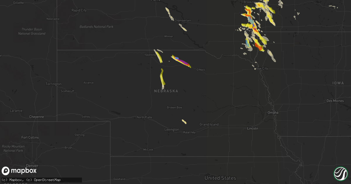
Hail Map in Nebraska on August 5, 2021
Get this storm
August 5 map
$229
one time, instant access
Download today. No call, no setup
Keep the $229
Bought the map and want the full workflow? Apply the entire $229 to a subscription within 7 days. None of it is wasted.
Every map, not just this one
This buys you this map. Subscription and you get every map we run, in the markets you choose from a few cities to whole states to nationwide. Plus real-time alerts the moment a storm fires.
Contact data
Name, contact info, occupancy, even credit band for addresses in the footprint. You go from where it hit to who to call.
Become the source they trust
Unlimited branding weather history reports on demand. You already have the documented answer ready for the property owner, and you are the one who showed up with it.
Property data and RoofTrace estimates
Pull up any address you have got, its value and the exact code rules for that jurisdiction, straight from One Click Code. Then RoofTrace estimates the squares, pitch, and roof value, priced the way you price.
Storm reports in Nebraska
Nebraska
| Date | Description |
|---|---|
| 08/05/20216:03 PM CDT | A local report indicates 1.00 inch wind near 1 SW STUART |
| 08/05/20215:45 PM CDT | A local report indicates 60 MPH wind near 19 S JOHNSTOWN |
| 08/05/20215:15 PM CDT | Wind gusts estimated at 80 mph. Several trees uprooted and broken off. A camper was rolled over and a grain bin was damaged. Power was also lost. |
| 08/05/20215:15 PM CDT | Very heavy rain with hail up to golf ball size was observed. |
| 08/05/20215:14 PM CDT | Roughly half mile of power poles snapped. Time estimated. |
| 08/05/20214:25 PM CDT | A local report indicates 1.00 inch wind near 5 S SPARKS |
| 08/05/202112:59 AM CDT | At 557 PM CDT, severe thunderstorms were located along a line extending from 18 miles south of Johnstown to 6 miles north of Elsmere to 14 miles north of Purdum, moving south at 35 mph. THESE ARE DESTRUCTIVE STORMS FOR ELSMERE AND PURDUM! HAZARD...80 mph wind gusts and ping pong ball size hail. SOURCE...Radar indicated. IMPACT...Flying debris will be dangerous to those caught without shelter. Mobile homes will be heavily damaged. Expect considerable damage to roofs, windows, and vehicles. Extensive tree damage and power outages are likely. Locations impacted include... Brewster, Dunning, Halsey, Elsmere, Purdum, Koshopah, Moon Lake, Hawley Flats, Willow Lake State Wildlife Management Area and Long Lake State Wildlife Management Area.This includes Highway 2 between mile markers 222 and 240. |
| 08/05/202112:49 AM CDT | At 548 PM CDT, a severe thunderstorm was located near Newport, or 15 miles east of Bassett, moving southeast at 40 mph. THIS IS A DESTRUCTIVE STORM APPROACHING STUART! HAZARD...Three inch hail and 70 mph wind gusts. SOURCE...Radar indicated. IMPACT...People and animals outdoors will be severely injured. Expect shattered windows, extensive damage to roofs, siding, and vehicles. Locations impacted include... O'neill, O'Neill, Atkinson, Stuart, Newport and Emmet. This includes the following highways... Highway 20 between mile markers 265 and 308. Highway 281 between mile markers 183 and 189. |
| 08/05/202112:39 AM CDT | At 539 PM CDT, a severe thunderstorm was located 12 miles southwest of Johnstown, or 18 miles southwest of Ainsworth, moving southeast at 30 mph. HAZARD...70 mph wind gusts and quarter size hail. SOURCE...Radar indicated. IMPACT...Hail damage to vehicles is expected. Expect considerable tree damage. Wind damage is also likely to mobile homes, roofs, and outbuildings. Locations impacted include... Moon Lake, Willow Lake State Wildlife Management Area and Long Lake State Wildlife Management Area. |
| 08/05/202112:13 AM CDT | At 513 PM CDT, severe thunderstorms were located along a line extending from 7 miles east of Springview to 7 miles west of Johnstown, moving southeast at 25 mph. HAZARD...Ping pong ball size hail and 60 mph wind gusts. SOURCE...Radar indicated. IMPACT...People and animals outdoors will be injured. Expect hail damage to roofs, siding, windows, and vehicles. Expect wind damage to roofs, siding, and trees. Locations impacted include... Ainsworth, Bassett, Long Pine, Newport, Johnstown, Wood Lake, Hofeld Lake, Bobcat State Wildlife Management Area, Meadville, Keller Park State Recreation Area, Thomas Creek State Wildlife Management Area, Pine Glen State Wildlife Refuge, Antelope Peak and Jones Lake.This includes the following highways... Highway 183 between mile markers 171 and 212. Highway 20 between mile markers 221 and 274. |
| 08/04/202111:40 PM CDT | At 440 PM CDT, a severe thunderstorm was located near Pleasanton, or 19 miles north of Kearney, moving southeast at 15 mph. HAZARD...60 mph wind gusts and quarter size hail. SOURCE...Radar indicated. IMPACT...Hail damage to vehicles is expected. Expect wind damage to roofs, siding, and trees. This severe thunderstorm will be near... Pleasanton around 455 PM CDT. |
All States Impacted by Hail Map on August 5, 2021
Cities Impacted by Hail Map on August 5, 2021
- Custer City, OK
- Taloga, OK
- Baltic, SD
- Wentworth, SD
- Crooks, SD
- Larchwood, IA
- Rock Rapids, IA
- Renner, SD
- Colton, SD
- Canton, SD
- Fairview, SD
- Ireton, IA
- Hartford, SD
- Garretson, SD
- Worthing, SD
- Chester, SD
- Flandreau, SD
- Brandon, SD
- Montrose, SD
- Rock Valley, IA
- Dell Rapids, SD
- Hills, MN
- Hudson, SD
- Trent, SD
- Sioux Falls, SD
- Madison, SD
- Valley Springs, SD
- Humboldt, SD
- Rutland, SD
- Hull, IA
- Volga, SD
- Sioux Center, IA
- Inwood, IA
- Alcester, SD
- Alvord, IA
- Nunda, SD
- Doon, IA
- Colman, SD
- Harrisburg, SD
- Egan, SD
- Hawarden, IA
- Sparks, NE
- Valentine, NE
- Hastings, MN
- Rueter, MO
- Kissee Mills, MO
- Ruthton, MN
- Holland, MN
- Sells, AZ
- Woodstock, MN
- Centerville, SD
- Lennox, SD
- Davis, SD
- Beresford, SD
- Cascade, ID
- Donnelly, ID
- Lake Benton, MN
- Aurora, SD
- Pipestone, MN
- Elkton, SD
- Lower Brule, SD
- Kennebec, SD
- Springview, NE
- Newport, NE
- Bassett, NE
- Chancellor, SD
- Council Grove, KS
- Madison Lake, MN
- Purdum, NE
- Amherst, NE
- Pleasanton, NE
- Miller, NE
- Mason City, NE
- Johnstown, NE
- Stuart, NE
- Garrison, MT
- Ainsworth, NE
- Mission, SD
- Haines, OR
- Cambridge, ID
- Midvale, ID
- Moran, WY
- Cottage Grove, MN
- Lindstrom, MN
- Center City, MN
- Edgerton, MN
- Kenneth, MN
- Adrian, MN
- Lismore, MN
- Wilmont, MN
- Chandler, MN
- Leota, MN
- Le Mars, IA
- Orange City, IA
- Alton, IA
- Remsen, IA
- Waseca, MN
- Maurice, IA
- Kingsley, IA
- Marcus, IA
- Pilot Rock, OR
- Afton, MN
- River Falls, WI
- Arco, MN
- Tyler, MN
- Ivanhoe, MN
- Reliance, SD
- Elgin, OR
- Elysian, MN
- Janesville, MN
- Waterville, MN
- Clinton, OK
- Butler, OK
- Pine City, MN
- Elk Point, SD
- Union, OR
- Minneota, MN
- Hardwick, MN
- Lynd, MN
- Rushmore, MN
- Porter, MN
- Lake Wilson, MN
- Allen, KS
- Edinburg, TX
- Henderson, MN
- New Prague, MN
- Isabella, OK
- Okeene, OK
- Luverne, MN
- Jasper, MN
- Beaver Creek, MN
- Nogales, AZ
- Grasston, MN
- Brook Park, MN
- Prairie City, OR
- La Grande, OR
- Moore, ID
- Howe, ID
- Canistota, SD
- Parker, SD
- Saint Paul, MN
- Wallowa, OR
- Hudson, WI
- Roberts, WI
- Sumpter, OR
- Baker City, OR
- Jeffers, MN
- Tracy, MN
- Wakonda, SD
- Irene, SD
- Vermillion, SD
- Volin, SD
- Jackson, NE
- Tea, SD
- Viborg, SD
- Saint Paul Park, MN
- Chisago City, MN
- Brandt, SD
- Chamberlain, SD
- Platte, SD
- Mountain Lake, MN
- Somerset, WI
- Houlton, WI
- Hendricks, MN
- White, SD
- Admire, KS
- Garvin, MN
- Rio Grande City, TX
- New Richmond, WI
- Lostine, OR
- Andover, MN
- Centuria, WI
- Stillwater, MN
- Northfield, MN
- Webster, MN
- Lonsdale, MN
- Marshall, MN
- Belle Plaine, MN
- Windom, MN
- Sheldon, IA
- Taneyville, MO
- Shafer, MN
- Taylors Falls, MN
- New Meadows, ID
- Inver Grove Heights, MN
- Lake Elmo, MN
- Newport, MN
- Prescott, WI
- South Saint Paul, MN
- Stanchfield, MN
- Rush City, MN
- Harris, MN
- Mansfield, SD
- Ponca, NE
- Saint Croix Falls, WI
- Cushing, WI
- Hugo, MN
- Osceola, WI
- Marine On Saint Croix, MN
- Forest Lake, MN
- Circle Pines, MN
- Foss, OK
- Bingham Lake, MN
- Currie, MN
- Grantsburg, WI
- North Branch, MN
- Mills, NE
- Arapaho, OK
- Atkinson, NE
- Brookings, SD
- Balaton, MN
- Lyons, SD


