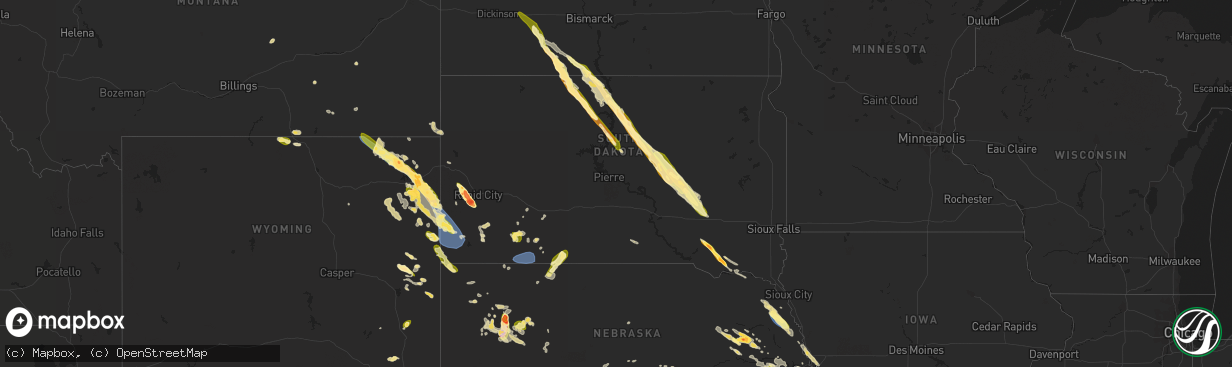
Hail Map in South Dakota on July 30, 2023
The weather event in South Dakota on July 30, 2023 includes Wind and Hail maps. 17 states and 1,033 cities were impacted and suffered possible damage. The total estimated number of properties impacted is 12,776.
Want more than just the map?
Turn this storm into a full workflow.
- Owner + property data so you know who to knock
- OnDemand branded weather history reports to win the "did we even have hail?" argument
- RoofTrace estimate so reps stop guessing numbers at the door
Bought this map? Upgrade within 7 days and we'll credit the $230. (10-15 min setup call)
Wind
Hail
12,776
Estimated number of impacted properties by a 1.00" hail or larger6,298
Estimated number of impacted properties by a 1.75" hail or larger222
Estimated number of impacted properties by a 2.50" hail or largerStorm reports in South Dakota
South Dakota
| Date | Description |
|---|---|
| 07/30/20233:24 PM CDT | Mping report |
| 07/30/20233:16 PM CDT | A local report indicates 3.25 inch wind near 2 E Sheridan Lake |
| 07/30/20233:14 PM CDT | A local report indicates 3.00 inch wind near 1 SSE Sheridan Lake |
| 07/30/20233:13 PM CDT | Hail size ranged from peas to golf balls. Time estimated from radar. |
| 07/30/20233:10 PM CDT | A local report indicates 2.50 inch wind near 1 NNW Sheridan Lake |
| 07/30/20233:02 PM CDT | A local report indicates 2.50 inch wind near 2 S Pactola Resv |
| 07/30/20233:01 PM CDT | Mping report |
| 07/30/20233:00 PM CDT | A local report indicates 3.00 inch wind near 1 SSE Pactola Resv |
| 07/30/20232:55 PM CDT | A local report indicates 1.50 inch wind near Johnson Siding |
| 07/30/20232:54 PM CDT | A local report indicates 2.00 inch wind near 1 ENE Pactola Resv |
| 07/30/20232:48 PM CDT | A local report indicates 1.75 inch wind near 2 NE Silver City |
| 07/30/20232:39 PM CDT | A local report indicates 1.00 inch wind near 4 N Silver City |
| 07/30/20232:36 PM CDT | Time estimated from radar. |
| 07/30/20231:35 PM CDT | Golf ball to tennis ball sized hail fell straight down from storm... And cracked the windshield on spotters parked pickup truck at home. |
| 07/30/202312:15 PM CDT | A local report indicates 1.50 inch wind near 7 E Sutton Bay Rec Area |
| 07/30/202312:06 PM CDT | Time estimated from radar. |
| 07/30/202312:05 PM CDT | A local report indicates 1.25 inch wind near 14 SSW Seneca |
| 07/30/202312:00 PM CDT | A local report indicates 1.00 inch wind near 7 NE Sutton Bay Rec Are |
| 07/30/202311:56 AM CDT | Report from mping: half dollar |
| 07/30/202311:35 AM CDT | A local report indicates 1.00 inch wind near 9 E Sunshine Bible Acad |
| 07/30/202311:26 AM CDT | A local report indicates 1.25 inch wind near 6 NW Lebanon |
| 07/30/202311:00 AM CDT | Ping pong to golfball sized hail via facebook. |
| 07/30/202310:52 AM CDT | Video via facebook. |
| 07/30/202310:28 AM CDT | A local report indicates 1.00 inch wind near Mobridge Municipal Airp |
| 07/30/20239:52 AM CDT | Public report of quarter to half dollar via facebook. Estimated time based on radar. |
| 07/30/20239:48 AM CDT | A local report indicates 1.00 inch wind near 7 SSE Mcintosh |
| 07/29/202311:19 PM CDT | A local report indicates 62 MPH wind near 4 E Cactus Flat |
| 07/29/202311:14 PM CDT | A local report indicates 61 MPH wind near 4 E Cactus Flat |
| 07/29/202310:49 PM CDT | A local report indicates 72 MPH wind near 11 W Hot Springs |
| 07/29/202310:44 PM CDT | A local report indicates 61 MPH wind near 11 W Hot Springs |
| 07/29/202310:42 PM CDT | A local report indicates 60 MPH wind near 10 W Edgemont |
| 07/29/202310:32 PM CDT | A local report indicates 60 MPH wind near 10 W Edgemont |
| 07/29/20239:54 PM CDT | A local report indicates 58 MPH wind near 8 W Jewel Cave |
| 07/29/20239:46 PM CDT | A local report indicates 65 MPH wind near 9 SW Batesland |
| 07/29/20239:45 PM CDT | 50-60 mph wind gusts. Wind changed direction multiple times. |
| 07/29/20239:45 PM CDT | 50-60 mph wind gusts. Wind changed direction multiple times. |
| 07/29/20239:35 PM CDT | A local report indicates 59 MPH wind near 3 NW Wasta |
| 07/29/20239:27 PM CDT | Marble size with a few quarters |
| 07/29/20239:21 PM CDT | A local report indicates 1.25 inch wind near 1 NNW Sharps Corner |
| 07/29/20237:43 PM CDT | A local report indicates 1.00 inch wind near 14 SSW Provo |
All States Impacted by Hail Map on July 30, 2023
Cities Impacted by Hail Map on July 30, 2023
- Pueblo, CO
- Penrose, CO
- Beulah, CO
- Rye, CO
- Avondale, CO
- Colorado City, CO
- Wetmore, CO
- Carson, ND
- Elgin, ND
- Flasher, ND
- Selfridge, ND
- Fort Yates, ND
- New Leipzig, ND
- Hebron, ND
- Glen Ullin, ND
- Richardton, ND
- Shields, ND
- McLaughlin, SD
- Wakpala, SD
- Fairfield, NE
- Glenvil, NE
- Deweese, NE
- McIntosh, SD
- Glenham, SD
- Mobridge, SD
- Mound City, SD
- Selby, SD
- Akaska, SD
- Trail City, SD
- Glencross, SD
- Timber Lake, SD
- Eagle Butte, SD
- Gettysburg, SD
- Hoven, SD
- Lebanon, SD
- Miller, SD
- Ree Heights, SD
- Highmore, SD
- Saint Lawrence, SD
- Wessington, SD
- Wessington Springs, SD
- Onida, SD
- Seneca, SD
- Alpena, SD
- Plankinton, SD
- Woonsocket, SD
- Letcher, SD
- Mount Vernon, SD
- Mitchell, SD
- Holabird, SD
- Agar, SD
- Inland, NE
- Winner, SD
- Colome, SD
- Hayden, AL
- Hastings, NE
- Clay Center, NE
- Taylor, ND
- Alabaster, AL
- Helena, AL
- Adamsville, AL
- Mulga, AL
- Bessemer, AL
- Quinton, AL
- Pelham, AL
- Raleigh, ND
- Bullhead, SD
- Brookwood, AL
- Dora, AL
- Bremen, AL
- Empire, AL
- Jasper, AL
- Rockford, AL
- Armour, SD
- Delmont, SD
- Tripp, SD
- Deadwood, SD
- Nemo, SD
- Rapid City, SD
- Hill City, SD
- Parkman, WY
- Dayton, WY
- Wisner, NE
- Pender, NE
- Wakefield, NE
- Emerson, NE
- Thurston, NE
- Madison, NE
- Creston, NE
- Tyndall, SD
- Avon, SD
- Keystone, SD
- Ranchester, WY
- Wolf, WY
- Granite Canon, WY
- Bancroft, NE
- Rosalie, NE
- Lyons, NE
- Stanton, NE
- Leigh, NE
- Prague, NE
- Malmo, NE
- Larslan, MT
- Cheyenne, WY
- Lindsay, NE
- Humphrey, NE
- Missouri Valley, IA
- Honey Creek, IA
- Nashua, MT
- Frazer, MT
- Wolf Point, MT
- Jacksonville, FL
- Jacksonville Beach, FL
- Wheatland, WY
- Manville, WY
- Broadus, MT
- Weston, WY
- Recluse, WY
- Gillette, WY
- Sterling, CO
- Atwood, CO
- Bailey, MS
- Meridian, MS
- Enterprise, MS
- Eclectic, AL
- Tallassee, AL
- Berryville, AR
- Eureka Springs, AR
- Clarkson, NE
- Wellington, CO
- Omaha, NE
- Lance Creek, WY
- Buford, WY
- Moorcroft, WY
- Amity, AR
- Akron, AL
- Roanoke, AL
- Marion, AL
- Greensboro, AL
- Forest, MS
- Lena, MS
- Wray, GA
- Broxton, GA
- Fitzgerald, GA
- Lumpkin, GA
- Wyola, MT
- Jeffersonville, GA
- Dry Branch, GA
- Eufaula, AL
- Adrian, GA
- Kite, GA
- Faunsdale, AL
- Newbern, AL
- Vance, AL
- Philadelphia, MS
- Union, MS
- Walnut Grove, MS
- Oakland, NE
- Craig, NE
- Blair, NE
- Marion, MS
- Livermore, CO
- Tie Siding, WY
- Lauderdale, MS
- Daleville, MS
- Toomsuba, MS
- Porterville, MS
- De Kalb, MS
- Scotland, SD
- Tabor, SD
- Conehatta, MS
- Decatur, MS
- Notasulga, AL
- Platte Center, NE
- Papillion, NE
- Glasgow, MT
- Edgefield, SC
- Hawkinsville, GA
- Petersburg, NE
- Schuyler, NE
- Newman Grove, NE
- Tilden, NE
- Arabi, GA
- Cordele, GA
- Council Bluffs, IA
- Underwood, IA
- Modale, IA
- Crescent, IA
- Ormond Beach, FL
- Yankton, SD
- Brent, AL
- Forsyth, MT
- Lead, SD
- Otoe, NE
- Avoca, NE
- Valdosta, GA
- Quitman, GA
- Monticello, AR
- Little Rock, MS
- Sparta, GA
- Willacoochee, GA
- Preston, GA
- Plains, GA
- Sawyerville, AL
- Morse Bluff, NE
- Abbeville, AL
- Tallahassee, FL
- Thomaston, AL
- Murdock, NE
- Rochelle, GA
- Pitts, GA
- Baxley, GA
- Alamo, GA
- Glenwood, GA
- Coolidge, GA
- Pavo, GA
- Centreville, AL
- Weston, NE
- Eagle Rock, MO
- Seligman, MO
- Cassville, MO
- Yutan, NE
- Ashland, NE
- Forkland, AL
- Dublin, GA
- Duncanville, AL
- Cottondale, AL
- Cobb, GA
- Dunbar, NE
- Nebraska City, NE
- Altoona, FL
- Soperton, GA
- Pinetta, FL
- Mauk, GA
- Junction City, GA
- Tekamah, NE
- Allen, NE
- Concord, NE
- Decatur, NE
- Dodge, NE
- Milledgeville, GA
- Eatonton, GA
- Union, NE
- Americus, GA
- Buena Vista, GA
- Ellaville, GA
- Ash Fork, AZ
- Bluffton, GA
- Arlington, GA
- Glen Saint Mary, FL
- Macclenny, FL
- Crawfordville, FL
- Adger, AL
- Mead, NE
- Colon, NE
- Wahoo, NE
- Cuba, AL
- Ward, AL
- Lisman, AL
- Rhine, GA
- Gainesville, AL
- Epes, AL
- Fairview, MO
- Stark City, MO
- Chunky, MS
- Collinsville, MS
- Denton, GA
- Mobile, AL
- Springfield, NE
- Gretna, NE
- Damascus, GA
- Ithaca, NE
- Ocala, FL
- East Dublin, GA
- Winnebago, NE
- Ames, NE
- Oakfield, GA
- Monroe, NE
- Moundville, AL
- Cochran, GA
- McCalla, AL
- Granby, MO
- Neosho, MO
- Neptune Beach, FL
- Columbus, GA
- Johnston, SC
- Trenton, SC
- Waycross, GA
- Leslie, GA
- Bruno, NE
- Sopchoppy, FL
- Hosford, FL
- Folkston, GA
- South Bend, NE
- Weeping Water, NE
- Greenwood, NE
- Louisville, NE
- Waterloo, NE
- Cedar Bluffs, NE
- Morgan, GA
- Warwick, GA
- Abie, NE
- Manley, NE
- Elkhorn, NE
- David City, NE
- Nehawka, NE
- Columbus, NE
- Linwood, NE
- Fremont, NE
- Bellwood, NE
- Elmwood, NE
- Alvo, NE
- Howells, NE
- Fordyce, NE
- Crofton, NE
- Rock Port, MO
- Gann Valley, SD
- Utica, SD
- Lesterville, SD
- Milan, GA
- Jacksonville, GA
- Carthage, MS
- Golden, MO
- Vida, MT
- Richey, MT
- Poplar, MT
- Hulett, WY
- Hebron, NE
- Deshler, NE
- Chester, NE
- Hubbell, NE
- Belleville, KS
- Munden, KS
- Byron, NE
- Ellsworth, NE
- Lakeside, NE
- Oshkosh, NE
- Alliance, NE
- Snyder, CO
- Sundance, WY
- Upton, WY
- Newcastle, WY
- Osage, WY
- Berryton, KS
- Lecompton, KS
- Tecumseh, KS
- Lawrence, KS
- Eudora, KS
- Overbrook, KS
- Baldwin City, KS
- Ottawa, KS
- Pomona, KS
- Topeka, KS
- Lyndon, KS
- Quenemo, KS
- Scranton, KS
- Carbondale, KS
- Wakarusa, KS
- Vassar, KS
- Agenda, KS
- Narka, KS
- Cuba, KS
- Aurora, KS
- Concordia, KS
- Bridgeport, NE
- Platte City, MO
- Farley, MO
- Leavenworth, KS
- Liberty, MO
- Fort Leavenworth, KS
- Smithville, MO
- Kansas City, KS
- Lansing, KS
- Tonganoxie, KS
- Kansas City, MO
- Easton, KS
- Waldron, MO
- Basehor, KS
- Weston, MO
- Odessa, MO
- Orrick, MO
- Camden Point, MO
- Kearney, MO
- Sibley, MO
- Grain Valley, MO
- Blue Springs, MO
- Wellington, MO
- Missouri City, MO
- Independence, MO
- Levasy, MO
- Bates City, MO
- Oak Grove, MO
- Buckner, MO
- Napoleon, MO
- Riverside, MO
- Excelsior Springs, MO
- Bonner Springs, KS
- Leawood, KS
- Overland Park, KS
- Lees Summit, MO
- Prairie Village, KS
- Lenexa, KS
- Shawnee, KS
- Mission, KS
- Edgerton, MO
- Grandview, MO
- Atchison, KS
- Edgerton, KS
- Gardner, KS
- Garnett, KS
- Williamsburg, KS
- Wellsville, KS
- Richmond, KS
- Rantoul, KS
- Greeley, KS
- Melvern, KS
- Princeton, KS
- Spring Hill, KS
- Westphalia, KS
- Osawatomie, KS
- Lane, KS
- Paola, KS
- Waverly, KS
- Edgemont, SD
- Harrison, NE
- Lambert, MT
- Savage, MT
- Bloomfield, MT
- Great Falls, MT
- Stockett, MT
- Belt, MT
- Sand Coulee, MT
- Gildford, MT
- Kremlin, MT
- Havre, MT
- Chinook, MT
- Lisco, NE
- Kyle, SD
- Merriman, NE
- Tuthill, SD
- Martin, SD
- Reading, KS
- Admire, KS
- Emporia, KS
- Neosho Rapids, KS
- Lebo, KS
- Hartford, KS
- Burlington, KS
- Osage City, KS
- Lone Jack, MO
- Centerview, MO
- Pleasant Hill, MO
- Greenwood, MO
- Warrensburg, MO
- Holden, MO
- Kingsville, MO
- Leeton, MO
- Strasburg, MO
- Raymore, MO
- Chilhowee, MO
- Cleveland, MO
- Garden City, MO
- Harrisonville, MO
- Adrian, MO
- Urich, MO
- Archie, MO
- Belton, MO
- East Lynne, MO
- Clinton, MO
- Blairstown, MO
- Butler, MO
- Freeman, MO
- Peculiar, MO
- Drexel, MO
- Creighton, MO
- Stilwell, KS
- Olathe, KS
- De Soto, KS
- Linwood, KS
- Bucyrus, KS
- Louisburg, KS
- La Cygne, KS
- Amoret, MO
- Amsterdam, MO
- Mound City, KS
- Welda, KS
- Parker, KS
- Centerville, KS
- Fontana, KS
- Pleasanton, KS
- Mapleton, KS
- Uniontown, KS
- Fulton, KS
- Prescott, KS
- Hume, MO
- Bronson, KS
- Foster, MO
- Colony, KS
- Blue Mound, KS
- Kincaid, KS
- La Harpe, KS
- Moran, KS
- Montrose, MO
- Appleton City, MO
- Quincy, MO
- Warsaw, MO
- Osceola, MO
- Deepwater, MO
- Calhoun, MO
- Lowry City, MO
- Schell City, MO
- Rockville, MO
- El Dorado Springs, MO
- Walker, MO
- Richards, MO
- Fort Scott, KS
- Rich Hill, MO
- Nevada, MO
- Harwood, MO
- Redfield, KS
- Farlington, KS
- Arcadia, KS
- Moundville, MO
- Arma, KS
- Hepler, KS
- Bronaugh, MO
- Deerfield, MO
- Girard, KS
- Garland, KS
- Milo, MO
- Liberal, MO
- Gridley, KS
- Le Roy, KS
- Neosho Falls, KS
- Custer, SD
- Owanka, SD
- Wall, SD
- Wasta, SD
- Pine Ridge, SD
- Batesland, SD
- Wounded Knee, SD
- Gordon, NE
- Porcupine, SD
- Geyser, MT
- Raynesford, MT
- Highwood, MT
- Zurich, MT
- Harlem, MT
- Hays, MT
- Lamar, MO
- Wheatland, MO
- Sheldon, MO
- Flemington, MO
- Humansville, MO
- Weaubleau, MO
- Stockton, MO
- Mulberry, KS
- Hermitage, MO
- Pittsburg, MO
- Jerico Springs, MO
- Collins, MO
- Polk, MO
- Louisburg, MO
- Buffalo, MO
- Half Way, MO
- Long Lane, MO
- Bolivar, MO
- Dunnegan, MO
- Phillipsburg, MO
- Fair Play, MO
- Dadeville, MO
- Lockwood, MO
- Arcola, MO
- Aldrich, MO
- Mindenmines, MO
- Franklin, KS
- Elkland, MO
- Greenfield, MO
- Conway, MO
- Pittsburg, KS
- Joplin, MO
- Clever, MO
- Reeds, MO
- Walnut Grove, MO
- Opolis, KS
- Billings, MO
- Butterfield, MO
- Sarcoxie, MO
- Willard, MO
- La Russell, MO
- Marionville, MO
- Diamond, MO
- Bois D Arc, MO
- Crane, MO
- Asbury, MO
- Stotts City, MO
- Purdy, MO
- Ash Grove, MO
- Carthage, MO
- Wheaton, MO
- Pleasant Hope, MO
- Verona, MO
- Monett, MO
- Jasper, MO
- Miller, MO
- Webb City, MO
- Wentworth, MO
- Aurora, MO
- Mount Vernon, MO
- Freistatt, MO
- Carterville, MO
- Springfield, MO
- Avilla, MO
- Republic, MO
- Oronogo, MO
- South Greenfield, MO
- Purcell, MO
- Neck City, MO
- Brighton, MO
- Fair Grove, MO
- Golden City, MO
- Carl Junction, MO
- Alba, MO
- Halltown, MO
- Exeter, MO
- Morrisville, MO
- Everton, MO
- Brookline, MO
- Pierce City, MO
- Frontenac, KS
- Marshfield, MO
- Strafford, MO
- Duenweg, MO
- Rocky Comfort, MO
- Stella, MO
- Weir, KS
- Galena, KS
- Scammon, KS
- Urbana, MO
- Hot Springs, SD
- Crete, NE
- Hallam, NE
- Rudyard, MT
- Burlingame, KS
- Cortland, NE
- Adams, NE
- Volborg, MT
- Scandia, KS
- Lusk, WY
- Jamestown, KS
- Supai, AZ
- Williams, AZ
- Louin, MS
- Bay Springs, MS
- Saint George, GA
- Bonifay, FL
- Green Forest, AR
- Alpena, AR
- Joplin, MT
- Chester, MT
- Crystal River, FL
- Maitland, MO
- Mound City, MO
- Fort Calhoun, NE
- Alford, FL
- Cottondale, FL
- Harrison, AR
- Wrightsville, GA
- Rockledge, GA
- Girard, GA
- Silver Lake, KS
- Rossville, KS
- Maple Hill, KS
- Saint Marys, KS
- Vendor, AR
- Birney, MT
- Beloit, KS
- Glen Elder, KS
- Barnard, KS
- Cleveland, AR
- Hattieville, AR
- Clinton, AR
- Center Ridge, AR
- Jerusalem, AR
- Fairburn, SD
- Bamberg, SC
- Denmark, SC
- Allen, KS
- Merino, CO
- Devils Tower, WY
- Brewton, AL
- Geraldine, MT
- Robertsdale, AL
- Thomasville, GA
- Lost Springs, WY
- Shawnee, WY
- Clarkdale, AZ
- Jerome, AZ
- Avon Park, FL
- Patterson, GA
- Blackshear, GA
- Easton, MO
- Sells, AZ
- Oregon, MO
- Marana, AZ
- Bogalusa, LA
- Carriere, MS
- Emelle, AL
- Portal, GA
- Ambrose, GA
- Marianna, FL
- Milford, NE
- Green Cove Springs, FL
- Rushville, NE
- Peru, NE
- Julian, NE
- Auburn, NE
- Talmage, NE
- Brock, NE
- Glendo, WY
- Belle Fourche, SD
- Natoma, KS
- Plainville, KS
- Buckatunna, MS
- Moselle, MS
- Seminary, MS
- Garrett, WY
- Pleasant Dale, NE
- Denton, NE
- Oral, SD
- Poplarville, MS
- Buffalo Gap, SD
- Crawford, NE
- Walterboro, SC
- Chalmette, LA
- Violet, LA
- New Orleans, LA
- Meraux, LA
- Sanderson, FL
- Hector, AR
- Pelsor, AR
- Witts Springs, AR
- Mount Judea, AR
- Defuniak Springs, FL
- Surrency, GA
- Odum, GA
- Bristol, GA
- Shell Knob, MO
- Loranger, LA
- Rose Hill, MS
- Quitman, MS
- Pachuta, MS
- Vossburg, MS
- Paulding, MS
- Clifton, KS
- Clyde, KS
- Lame Deer, MT
- Fargo, GA
- Fort McCoy, FL
- Torrington, WY
- Alzada, MT
- Theodore, AL
- Clermont, FL
- Lawrence, MS
- Raleigh, MS
- Huntsville, AR
- Bartow, GA
- Delia, KS
- Picayune, MS
- Bishopville, SC
- Brownville, NE
- Nemaha, NE
- Hickory, MS
- Allen, SD
- Soso, MS
- Ellisville, MS
- Big Sandy, MT
- Hemingford, NE
- Otter, MT
- Stonewall, MS
- Inverness, MT
- Millen, GA
- Garfield, GA
- Atlantic Beach, FL
- Ponte Vedra Beach, FL
- Perkinston, MS
- Saucier, MS
- Kiln, MS
- Pass Christian, MS
- Spearfish, SD
- Grand Bay, AL
- Irvington, AL
- Moss Point, MS
- Statesboro, GA
- Grover, CO
- Watson, MO
- Bingham, NE
- Aliceville, AL
- Kissimmee, FL
- Starke, FL
- Keystone Heights, FL
- Lawtey, FL
- Webb, AL
- Dothan, AL
- Cowarts, AL
- Verdon, NE
- Hamburg, IA
- Lorton, NE
- Falls City, NE
- Shubert, NE
- Stella, NE
- Johnson, NE
- Frostproof, FL
- Savannah, GA
- Heidelberg, MS
- Fairfax, MO
- Skidmore, MO
- Sebring, FL
- Marsland, NE
- Nalcrest, FL
- Lake Wales, FL
- Conrad, MT
- Brady, MT
- Riceboro, GA
- Sylvania, GA
- Morton, MS
- Pelahatchie, MS
- Saint Johns, FL
- Mershon, GA
- Hoboken, GA
- Savannah, MO
- Saint Joseph, MO
- Boys Town, NE
- Beverly Hills, FL
- Lecanto, FL
- Whigham, GA
- Waynesboro, MS
- Lake, MS
- Scenic, SD
- Fishtail, MT
- Emmett, KS
- Taylorsville, MS
- Shubuta, MS
- Livingston, AL
- Bayard, NE
- Hingham, MT
- Jachin, AL
- Martin, SC
- Jasper, AR
- Marble Falls, AR
- Newton, MS
- Clarksdale, MO
- Stewartsville, MO
- Hammond, LA
- Alma, GA
- Hazlehurst, GA
- Fairfax, SC
- Lodge, SC
- Smoaks, SC
- Compton, AR
- Collins, MS
- Kaycee, WY
- Pickrell, NE
- Hinsdale, MT
- Vandalia, MT
- Saint Marie, MT
- Fort Peck, MT
- Galena, MO
- Nixa, MO
- Rogersville, MO
- Fordland, MO
- Ozark, MO
- Sparta, MO
- Bruner, MO
- Niangua, MO
- Seymour, MO
- Highlandville, MO
- Spokane, MO
- Chestnutridge, MO
- Walnut Shade, MO
- Chadwick, MO
- Forsyth, MO
- Oldfield, MO
- Ponce De Leon, MO
- Ava, MO
- Reeds Spring, MO
- Cape Fair, MO
- Garrison, MO
- Kissee Mills, MO
- Lakeview, AR
- Powersite, MO
- Hollister, MO
- Thornfield, MO
- Wasola, MO
- Gainesville, MO
- Lampe, MO
- Theodosia, MO
- Protem, MO
- Peel, AR
- Gassville, AR
- Lead Hill, AR
- Yellville, AR
- Omaha, AR
- Blue Eye, MO
- Ridgedale, MO
- Branson, MO
- Midway, AR
- Kirbyville, MO
- Rockaway Beach, MO
- Rueter, MO
- Mountain Home, AR
- Bradleyville, MO
- Oakland, AR
- Cedarcreek, MO
- Bull Shoals, AR
- Squires, MO
- Noble, MO
- Isabella, MO
- Kimberling City, MO
- Pontiac, MO
- Taneyville, MO
- Cotter, AR
- Norfork, AR
- Flippin, AR
- Oak Grove, AR
- Summit, AR
- Everton, AR
- Saint Joe, AR
- Onia, AR
- Marshall, AR
- Pyatt, AR
- Valley Springs, AR
- Harriet, AR
- Leslie, AR
- Timbo, AR
- Big Flat, AR
- Gilbert, AR
- Pindall, AR
- Western Grove, AR
- Hasty, AR
- Washburn, MO
- Kingston, AR
- Deer, AR
- Parthenon, AR
- Ponca, AR
- Garfield, AR
- Rogers, AR
- Callaway, NE
- Calico Rock, AR
- Ashby, NE
- Everest, KS
- Interior, SD
- Humboldt, KS
- Erie, KS
- Savonburg, KS
- Chanute, KS
- Hartington, NE
- Lloyd, MT
- Guion, AR
- Angora, NE
- Hartman, AR
- Clarksville, AR
- Custer, MT
- Soldier, KS
- Havensville, KS
- Lewellen, NE
- Melbourne, AR
- Clatonia, NE
- Wilber, NE
- Wood River, NE
- Five Points, AL
- Loup City, NE
- Laurel, NE
- Brewster, NE
- Grand Island, NE
- Cairo, NE
- Shelton, NE
- Arthur, NE
- Virginia, NE
- Crab Orchard, NE
- Lewiston, NE
- Filley, NE
- Dorchester, NE
- Burchard, NE
- Steinauer, NE
- Elk Creek, NE
- Firth, NE
- Tecumseh, NE
- Ansley, NE
- Mountain View, AR
- Springfield, SD
- Ashton, NE
- Ravenna, NE
- Rockville, NE
- Tucson, AZ
- Sahuarita, AZ
- Hyannis, NE
- Saco, MT
- Batesville, AR
- Horton, KS
- Hiawatha, KS
- Stapleton, NE
- Brady, NE
- Arnold, NE
- Maxwell, NE
- Scotland, AR
- Martell, NE
- De Witt, NE
- Hay Springs, NE
- Broadwater, NE
- Virgil, SD
- Malta, MT
- Wellton, AZ
- Dover, AR
- Hogeland, MT
- Saint Edward, NE
- Holton, KS
- Mayetta, KS
- Camden, AL
- Merna, NE
- Brockton, MT
- Flaxville, MT
- Meadow Grove, NE
- Twin City, GA
- Memphis, NE
- Elgin, NE
- Oakdale, NE
- Battle Creek, NE
- Sumiton, AL
- Leary, GA
- North Bend, NE
- Wadley, GA
- Bastrop, LA


