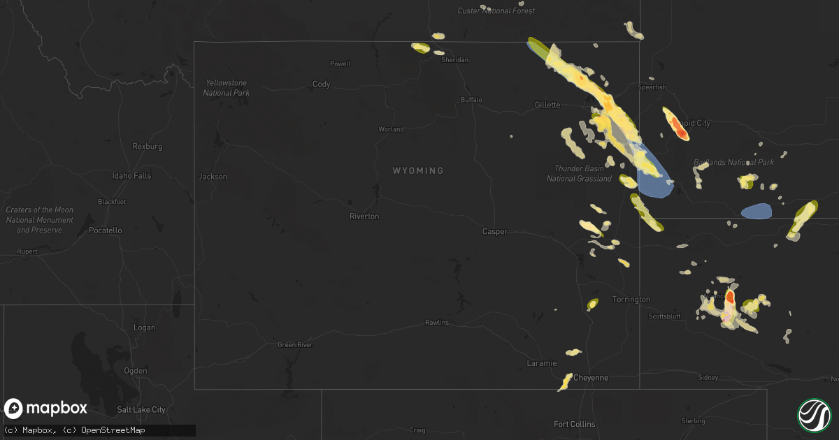
Hail Map in Wyoming on July 30, 2023
Get this storm
July 30 map
$229
one time, instant access
Download today. No call, no setup
Keep the $229
Bought the map and want the full workflow? Apply the entire $229 to a subscription within 7 days. None of it is wasted.
Every map, not just this one
This buys you this map. Subscription and you get every map we run, in the markets you choose from a few cities to whole states to nationwide. Plus real-time alerts the moment a storm fires.
Contact data
Name, contact info, occupancy, even credit band for addresses in the footprint. You go from where it hit to who to call.
Become the source they trust
Unlimited branding weather history reports on demand. You already have the documented answer ready for the property owner, and you are the one who showed up with it.
Property data and RoofTrace estimates
Pull up any address you have got, its value and the exact code rules for that jurisdiction, straight from One Click Code. Then RoofTrace estimates the squares, pitch, and roof value, priced the way you price.
Storm reports in Wyoming
Wyoming
| Date | Description |
|---|---|
| 07/30/20236:44 PM CDT | Several powerpoles snapped. |
| 07/30/20236:44 PM CDT | Camper and horse trailer blown over. |
| 07/30/20236:44 PM CDT | A local report indicates 1.75 inch wind near 2 WNW Oshoto |
| 07/30/20236:11 PM CDT | Side by side atv and playground equipment blown over. Wind equipment showed 60 plus mph. |
| 07/30/20236:11 PM CDT | Side by side atv and playground equipment blown over. Wind equipment showed 60 plus mph. |
| 07/30/20236:08 PM CDT | Gusts estimated 70-80 mph. Several powerpoles in the area snapped. 30 inch diameter tree snapped. |
| 07/30/20235:00 PM CDT | Few quarters. Mostly nickels. |
| 07/29/20239:45 PM CDT | A local report indicates 60 MPH wind near 11 NE Morrisey |
| 07/29/20239:42 PM CDT | Mesonet station wy50 mills 2 ne |
| 07/29/20239:36 PM CDT | Asos station kcpr casper airport. |
| 07/29/20238:17 PM CDT | A local report indicates 1.75 inch wind near 2 NE Upton |
| 07/29/20237:49 PM CDT | A local report indicates 1.50 inch wind near 15 S Sundance |
| 07/29/20237:26 PM CDT | A local report indicates 1.75 inch wind near 10 WSW Sundance |
| 07/29/20237:21 PM CDT | Mping report |
| 07/29/20237:14 PM CDT | Fence line down. Few tree branches down. 175 gallon feed tubs blown 20 feet. |
| 07/29/20237:14 PM CDT | Fence line down. Few tree branches down. 175 gallon feed tubs blown 20 feet. |
| 07/29/20237:02 PM CDT | Mostly nickels and dimes. 60-70 mph wind gust with initial hail and torrential rain. |
| 07/29/20237:02 PM CDT | Mostly nickels and dimes. 60-70 mph wind gust with initial hail and torrential rain. |
All States Impacted by Hail Map on July 30, 2023
Cities Impacted by Hail Map on July 30, 2023
- Pueblo, CO
- Penrose, CO
- Beulah, CO
- Rye, CO
- Avondale, CO
- Colorado City, CO
- Wetmore, CO
- Carson, ND
- Elgin, ND
- Flasher, ND
- Selfridge, ND
- Fort Yates, ND
- New Leipzig, ND
- Hebron, ND
- Glen Ullin, ND
- Richardton, ND
- Shields, ND
- McLaughlin, SD
- Wakpala, SD
- Fairfield, NE
- Glenvil, NE
- Deweese, NE
- McIntosh, SD
- Glenham, SD
- Mobridge, SD
- Mound City, SD
- Selby, SD
- Akaska, SD
- Trail City, SD
- Glencross, SD
- Timber Lake, SD
- Eagle Butte, SD
- Gettysburg, SD
- Hoven, SD
- Lebanon, SD
- Miller, SD
- Ree Heights, SD
- Highmore, SD
- Saint Lawrence, SD
- Wessington, SD
- Wessington Springs, SD
- Onida, SD
- Seneca, SD
- Alpena, SD
- Plankinton, SD
- Woonsocket, SD
- Letcher, SD
- Mount Vernon, SD
- Mitchell, SD
- Holabird, SD
- Agar, SD
- Inland, NE
- Winner, SD
- Colome, SD
- Hayden, AL
- Hastings, NE
- Clay Center, NE
- Taylor, ND
- Alabaster, AL
- Helena, AL
- Adamsville, AL
- Mulga, AL
- Bessemer, AL
- Quinton, AL
- Pelham, AL
- Raleigh, ND
- Bullhead, SD
- Brookwood, AL
- Dora, AL
- Bremen, AL
- Empire, AL
- Jasper, AL
- Rockford, AL
- Armour, SD
- Delmont, SD
- Tripp, SD
- Deadwood, SD
- Nemo, SD
- Rapid City, SD
- Hill City, SD
- Parkman, WY
- Dayton, WY
- Wisner, NE
- Pender, NE
- Wakefield, NE
- Emerson, NE
- Thurston, NE
- Madison, NE
- Creston, NE
- Tyndall, SD
- Avon, SD
- Keystone, SD
- Ranchester, WY
- Wolf, WY
- Granite Canon, WY
- Bancroft, NE
- Rosalie, NE
- Lyons, NE
- Stanton, NE
- Leigh, NE
- Prague, NE
- Malmo, NE
- Larslan, MT
- Cheyenne, WY
- Lindsay, NE
- Humphrey, NE
- Missouri Valley, IA
- Honey Creek, IA
- Nashua, MT
- Frazer, MT
- Wolf Point, MT
- Jacksonville, FL
- Jacksonville Beach, FL
- Wheatland, WY
- Manville, WY
- Broadus, MT
- Weston, WY
- Recluse, WY
- Gillette, WY
- Sterling, CO
- Atwood, CO
- Bailey, MS
- Meridian, MS
- Enterprise, MS
- Eclectic, AL
- Tallassee, AL
- Berryville, AR
- Eureka Springs, AR
- Clarkson, NE
- Wellington, CO
- Omaha, NE
- Lance Creek, WY
- Buford, WY
- Moorcroft, WY
- Amity, AR
- Akron, AL
- Roanoke, AL
- Marion, AL
- Greensboro, AL
- Forest, MS
- Lena, MS
- Wray, GA
- Broxton, GA
- Fitzgerald, GA
- Lumpkin, GA
- Wyola, MT
- Jeffersonville, GA
- Dry Branch, GA
- Eufaula, AL
- Adrian, GA
- Kite, GA
- Faunsdale, AL
- Newbern, AL
- Vance, AL
- Philadelphia, MS
- Union, MS
- Walnut Grove, MS
- Oakland, NE
- Craig, NE
- Blair, NE
- Marion, MS
- Livermore, CO
- Tie Siding, WY
- Lauderdale, MS
- Daleville, MS
- Toomsuba, MS
- Porterville, MS
- De Kalb, MS
- Scotland, SD
- Tabor, SD
- Conehatta, MS
- Decatur, MS
- Notasulga, AL
- Platte Center, NE
- Papillion, NE
- Glasgow, MT
- Edgefield, SC
- Hawkinsville, GA
- Petersburg, NE
- Schuyler, NE
- Newman Grove, NE
- Tilden, NE
- Arabi, GA
- Cordele, GA
- Council Bluffs, IA
- Underwood, IA
- Modale, IA
- Crescent, IA
- Ormond Beach, FL
- Yankton, SD
- Brent, AL
- Forsyth, MT
- Lead, SD
- Otoe, NE
- Avoca, NE
- Valdosta, GA
- Quitman, GA
- Monticello, AR
- Little Rock, MS
- Sparta, GA
- Willacoochee, GA
- Preston, GA
- Plains, GA
- Sawyerville, AL
- Morse Bluff, NE
- Abbeville, AL
- Tallahassee, FL
- Thomaston, AL
- Murdock, NE
- Rochelle, GA
- Pitts, GA
- Baxley, GA
- Alamo, GA
- Glenwood, GA
- Coolidge, GA
- Pavo, GA
- Centreville, AL
- Weston, NE
- Eagle Rock, MO
- Seligman, MO
- Cassville, MO
- Yutan, NE
- Ashland, NE
- Forkland, AL
- Dublin, GA
- Duncanville, AL
- Cottondale, AL
- Cobb, GA
- Dunbar, NE
- Nebraska City, NE
- Altoona, FL
- Soperton, GA
- Pinetta, FL
- Mauk, GA
- Junction City, GA
- Tekamah, NE
- Allen, NE
- Concord, NE
- Decatur, NE
- Dodge, NE
- Milledgeville, GA
- Eatonton, GA
- Union, NE
- Americus, GA
- Buena Vista, GA
- Ellaville, GA
- Ash Fork, AZ
- Bluffton, GA
- Arlington, GA
- Glen Saint Mary, FL
- Macclenny, FL
- Crawfordville, FL
- Adger, AL
- Mead, NE
- Colon, NE
- Wahoo, NE
- Cuba, AL
- Ward, AL
- Lisman, AL
- Rhine, GA
- Gainesville, AL
- Epes, AL
- Fairview, MO
- Stark City, MO
- Chunky, MS
- Collinsville, MS
- Denton, GA
- Mobile, AL
- Springfield, NE
- Gretna, NE
- Damascus, GA
- Ithaca, NE
- Ocala, FL
- East Dublin, GA
- Winnebago, NE
- Ames, NE
- Oakfield, GA
- Monroe, NE
- Moundville, AL
- Cochran, GA
- McCalla, AL
- Granby, MO
- Neosho, MO
- Neptune Beach, FL
- Columbus, GA
- Johnston, SC
- Trenton, SC
- Waycross, GA
- Leslie, GA
- Bruno, NE
- Sopchoppy, FL
- Hosford, FL
- Folkston, GA
- South Bend, NE
- Weeping Water, NE
- Greenwood, NE
- Louisville, NE
- Waterloo, NE
- Cedar Bluffs, NE
- Morgan, GA
- Warwick, GA
- Abie, NE
- Manley, NE
- Elkhorn, NE
- David City, NE
- Nehawka, NE
- Columbus, NE
- Linwood, NE
- Fremont, NE
- Bellwood, NE
- Elmwood, NE
- Alvo, NE
- Howells, NE
- Fordyce, NE
- Crofton, NE
- Rock Port, MO
- Gann Valley, SD
- Utica, SD
- Lesterville, SD
- Milan, GA
- Jacksonville, GA
- Carthage, MS
- Golden, MO
- Vida, MT
- Richey, MT
- Poplar, MT
- Hulett, WY
- Hebron, NE
- Deshler, NE
- Chester, NE
- Hubbell, NE
- Belleville, KS
- Munden, KS
- Byron, NE
- Ellsworth, NE
- Lakeside, NE
- Oshkosh, NE
- Alliance, NE
- Snyder, CO
- Sundance, WY
- Upton, WY
- Newcastle, WY
- Osage, WY
- Berryton, KS
- Lecompton, KS
- Tecumseh, KS
- Lawrence, KS
- Eudora, KS
- Overbrook, KS
- Baldwin City, KS
- Ottawa, KS
- Pomona, KS
- Topeka, KS
- Lyndon, KS
- Quenemo, KS
- Scranton, KS
- Carbondale, KS
- Wakarusa, KS
- Vassar, KS
- Agenda, KS
- Narka, KS
- Cuba, KS
- Aurora, KS
- Concordia, KS
- Bridgeport, NE
- Platte City, MO
- Farley, MO
- Leavenworth, KS
- Liberty, MO
- Fort Leavenworth, KS
- Smithville, MO
- Kansas City, KS
- Lansing, KS
- Tonganoxie, KS
- Kansas City, MO
- Easton, KS
- Waldron, MO
- Basehor, KS
- Weston, MO
- Odessa, MO
- Orrick, MO
- Camden Point, MO
- Kearney, MO
- Sibley, MO
- Grain Valley, MO
- Blue Springs, MO
- Wellington, MO
- Missouri City, MO
- Independence, MO
- Levasy, MO
- Bates City, MO
- Oak Grove, MO
- Buckner, MO
- Napoleon, MO
- Riverside, MO
- Excelsior Springs, MO
- Bonner Springs, KS
- Leawood, KS
- Overland Park, KS
- Lees Summit, MO
- Prairie Village, KS
- Lenexa, KS
- Shawnee, KS
- Mission, KS
- Edgerton, MO
- Grandview, MO
- Atchison, KS
- Edgerton, KS
- Gardner, KS
- Garnett, KS
- Williamsburg, KS
- Wellsville, KS
- Richmond, KS
- Rantoul, KS
- Greeley, KS
- Melvern, KS
- Princeton, KS
- Spring Hill, KS
- Westphalia, KS
- Osawatomie, KS
- Lane, KS
- Paola, KS
- Waverly, KS
- Edgemont, SD
- Harrison, NE
- Lambert, MT
- Savage, MT
- Bloomfield, MT
- Great Falls, MT
- Stockett, MT
- Belt, MT
- Sand Coulee, MT
- Gildford, MT
- Kremlin, MT
- Havre, MT
- Chinook, MT
- Lisco, NE
- Kyle, SD
- Merriman, NE
- Tuthill, SD
- Martin, SD
- Reading, KS
- Admire, KS
- Emporia, KS
- Neosho Rapids, KS
- Lebo, KS
- Hartford, KS
- Burlington, KS
- Osage City, KS
- Lone Jack, MO
- Centerview, MO
- Pleasant Hill, MO
- Greenwood, MO
- Warrensburg, MO
- Holden, MO
- Kingsville, MO
- Leeton, MO
- Strasburg, MO
- Raymore, MO
- Chilhowee, MO
- Cleveland, MO
- Garden City, MO
- Harrisonville, MO
- Adrian, MO
- Urich, MO
- Archie, MO
- Belton, MO
- East Lynne, MO
- Clinton, MO
- Blairstown, MO
- Butler, MO
- Freeman, MO
- Peculiar, MO
- Drexel, MO
- Creighton, MO
- Stilwell, KS
- Olathe, KS
- De Soto, KS
- Linwood, KS
- Bucyrus, KS
- Louisburg, KS
- La Cygne, KS
- Amoret, MO
- Amsterdam, MO
- Mound City, KS
- Welda, KS
- Parker, KS
- Centerville, KS
- Fontana, KS
- Pleasanton, KS
- Mapleton, KS
- Uniontown, KS
- Fulton, KS
- Prescott, KS
- Hume, MO
- Bronson, KS
- Foster, MO
- Colony, KS
- Blue Mound, KS
- Kincaid, KS
- La Harpe, KS
- Moran, KS
- Montrose, MO
- Appleton City, MO
- Quincy, MO
- Warsaw, MO
- Osceola, MO
- Deepwater, MO
- Calhoun, MO
- Lowry City, MO
- Schell City, MO
- Rockville, MO
- El Dorado Springs, MO
- Walker, MO
- Richards, MO
- Fort Scott, KS
- Rich Hill, MO
- Nevada, MO
- Harwood, MO
- Redfield, KS
- Farlington, KS
- Arcadia, KS
- Moundville, MO
- Arma, KS
- Hepler, KS
- Bronaugh, MO
- Deerfield, MO
- Girard, KS
- Garland, KS
- Milo, MO
- Liberal, MO
- Gridley, KS
- Le Roy, KS
- Neosho Falls, KS
- Custer, SD
- Owanka, SD
- Wall, SD
- Wasta, SD
- Pine Ridge, SD
- Batesland, SD
- Wounded Knee, SD
- Gordon, NE
- Porcupine, SD
- Geyser, MT
- Raynesford, MT
- Highwood, MT
- Zurich, MT
- Harlem, MT
- Hays, MT
- Lamar, MO
- Wheatland, MO
- Sheldon, MO
- Flemington, MO
- Humansville, MO
- Weaubleau, MO
- Stockton, MO
- Mulberry, KS
- Hermitage, MO
- Pittsburg, MO
- Jerico Springs, MO
- Collins, MO
- Polk, MO
- Louisburg, MO
- Buffalo, MO
- Half Way, MO
- Long Lane, MO
- Bolivar, MO
- Dunnegan, MO
- Phillipsburg, MO
- Fair Play, MO
- Dadeville, MO
- Lockwood, MO
- Arcola, MO
- Aldrich, MO
- Mindenmines, MO
- Franklin, KS
- Elkland, MO
- Greenfield, MO
- Conway, MO
- Pittsburg, KS
- Joplin, MO
- Clever, MO
- Reeds, MO
- Walnut Grove, MO
- Opolis, KS
- Billings, MO
- Butterfield, MO
- Sarcoxie, MO
- Willard, MO
- La Russell, MO
- Marionville, MO
- Diamond, MO
- Bois D Arc, MO
- Crane, MO
- Asbury, MO
- Stotts City, MO
- Purdy, MO
- Ash Grove, MO
- Carthage, MO
- Wheaton, MO
- Pleasant Hope, MO
- Verona, MO
- Monett, MO
- Jasper, MO
- Miller, MO
- Webb City, MO
- Wentworth, MO
- Aurora, MO
- Mount Vernon, MO
- Freistatt, MO
- Carterville, MO
- Springfield, MO
- Avilla, MO
- Republic, MO
- Oronogo, MO
- South Greenfield, MO
- Purcell, MO
- Neck City, MO
- Brighton, MO
- Fair Grove, MO
- Golden City, MO
- Carl Junction, MO
- Alba, MO
- Halltown, MO
- Exeter, MO
- Morrisville, MO
- Everton, MO
- Brookline, MO
- Pierce City, MO
- Frontenac, KS
- Marshfield, MO
- Strafford, MO
- Duenweg, MO
- Rocky Comfort, MO
- Stella, MO
- Weir, KS
- Galena, KS
- Scammon, KS
- Urbana, MO
- Hot Springs, SD
- Crete, NE
- Hallam, NE
- Rudyard, MT
- Burlingame, KS
- Cortland, NE
- Adams, NE
- Volborg, MT
- Scandia, KS
- Lusk, WY
- Jamestown, KS
- Supai, AZ
- Williams, AZ
- Louin, MS
- Bay Springs, MS
- Saint George, GA
- Bonifay, FL
- Green Forest, AR
- Alpena, AR
- Joplin, MT
- Chester, MT
- Crystal River, FL
- Maitland, MO
- Mound City, MO
- Fort Calhoun, NE
- Alford, FL
- Cottondale, FL
- Harrison, AR
- Wrightsville, GA
- Rockledge, GA
- Girard, GA
- Silver Lake, KS
- Rossville, KS
- Maple Hill, KS
- Saint Marys, KS
- Vendor, AR
- Birney, MT
- Beloit, KS
- Glen Elder, KS
- Barnard, KS
- Cleveland, AR
- Hattieville, AR
- Clinton, AR
- Center Ridge, AR
- Jerusalem, AR
- Fairburn, SD
- Bamberg, SC
- Denmark, SC
- Allen, KS
- Merino, CO
- Devils Tower, WY
- Brewton, AL
- Geraldine, MT
- Robertsdale, AL
- Thomasville, GA
- Lost Springs, WY
- Shawnee, WY
- Clarkdale, AZ
- Jerome, AZ
- Avon Park, FL
- Patterson, GA
- Blackshear, GA
- Easton, MO
- Sells, AZ
- Oregon, MO
- Marana, AZ
- Bogalusa, LA
- Carriere, MS
- Emelle, AL
- Portal, GA
- Ambrose, GA
- Marianna, FL
- Milford, NE
- Green Cove Springs, FL
- Rushville, NE
- Peru, NE
- Julian, NE
- Auburn, NE
- Talmage, NE
- Brock, NE
- Glendo, WY
- Belle Fourche, SD
- Natoma, KS
- Plainville, KS
- Buckatunna, MS
- Moselle, MS
- Seminary, MS
- Garrett, WY
- Pleasant Dale, NE
- Denton, NE
- Oral, SD
- Poplarville, MS
- Buffalo Gap, SD
- Crawford, NE
- Walterboro, SC
- Chalmette, LA
- Violet, LA
- New Orleans, LA
- Meraux, LA
- Sanderson, FL
- Hector, AR
- Pelsor, AR
- Witts Springs, AR
- Mount Judea, AR
- Defuniak Springs, FL
- Surrency, GA
- Odum, GA
- Bristol, GA
- Shell Knob, MO
- Loranger, LA
- Rose Hill, MS
- Quitman, MS
- Pachuta, MS
- Vossburg, MS
- Paulding, MS
- Clifton, KS
- Clyde, KS
- Lame Deer, MT
- Fargo, GA
- Fort McCoy, FL
- Torrington, WY
- Alzada, MT
- Theodore, AL
- Clermont, FL
- Lawrence, MS
- Raleigh, MS
- Huntsville, AR
- Bartow, GA
- Delia, KS
- Picayune, MS
- Bishopville, SC
- Brownville, NE
- Nemaha, NE
- Hickory, MS
- Allen, SD
- Soso, MS
- Ellisville, MS
- Big Sandy, MT
- Hemingford, NE
- Otter, MT
- Stonewall, MS
- Inverness, MT
- Millen, GA
- Garfield, GA
- Atlantic Beach, FL
- Ponte Vedra Beach, FL
- Perkinston, MS
- Saucier, MS
- Kiln, MS
- Pass Christian, MS
- Spearfish, SD
- Grand Bay, AL
- Irvington, AL
- Moss Point, MS
- Statesboro, GA
- Grover, CO
- Watson, MO
- Bingham, NE
- Aliceville, AL
- Kissimmee, FL
- Starke, FL
- Keystone Heights, FL
- Lawtey, FL
- Webb, AL
- Dothan, AL
- Cowarts, AL
- Verdon, NE
- Hamburg, IA
- Lorton, NE
- Falls City, NE
- Shubert, NE
- Stella, NE
- Johnson, NE
- Frostproof, FL
- Savannah, GA
- Heidelberg, MS
- Fairfax, MO
- Skidmore, MO
- Sebring, FL
- Marsland, NE
- Nalcrest, FL
- Lake Wales, FL
- Conrad, MT
- Brady, MT
- Riceboro, GA
- Sylvania, GA
- Morton, MS
- Pelahatchie, MS
- Saint Johns, FL
- Mershon, GA
- Hoboken, GA
- Savannah, MO
- Saint Joseph, MO
- Boys Town, NE
- Beverly Hills, FL
- Lecanto, FL
- Whigham, GA
- Waynesboro, MS
- Lake, MS
- Scenic, SD
- Fishtail, MT
- Emmett, KS
- Taylorsville, MS
- Shubuta, MS
- Livingston, AL
- Bayard, NE
- Hingham, MT
- Jachin, AL
- Martin, SC
- Jasper, AR
- Marble Falls, AR
- Newton, MS
- Clarksdale, MO
- Stewartsville, MO
- Hammond, LA
- Alma, GA
- Hazlehurst, GA
- Fairfax, SC
- Lodge, SC
- Smoaks, SC
- Compton, AR
- Collins, MS
- Kaycee, WY
- Pickrell, NE
- Hinsdale, MT
- Vandalia, MT
- Saint Marie, MT
- Fort Peck, MT
- Galena, MO
- Nixa, MO
- Rogersville, MO
- Fordland, MO
- Ozark, MO
- Sparta, MO
- Bruner, MO
- Niangua, MO
- Seymour, MO
- Highlandville, MO
- Spokane, MO
- Chestnutridge, MO
- Walnut Shade, MO
- Chadwick, MO
- Forsyth, MO
- Oldfield, MO
- Ponce De Leon, MO
- Ava, MO
- Reeds Spring, MO
- Cape Fair, MO
- Garrison, MO
- Kissee Mills, MO
- Lakeview, AR
- Powersite, MO
- Hollister, MO
- Thornfield, MO
- Wasola, MO
- Gainesville, MO
- Lampe, MO
- Theodosia, MO
- Protem, MO
- Peel, AR
- Gassville, AR
- Lead Hill, AR
- Yellville, AR
- Omaha, AR
- Blue Eye, MO
- Ridgedale, MO
- Branson, MO
- Midway, AR
- Kirbyville, MO
- Rockaway Beach, MO
- Rueter, MO
- Mountain Home, AR
- Bradleyville, MO
- Oakland, AR
- Cedarcreek, MO
- Bull Shoals, AR
- Squires, MO
- Noble, MO
- Isabella, MO
- Kimberling City, MO
- Pontiac, MO
- Taneyville, MO
- Cotter, AR
- Norfork, AR
- Flippin, AR
- Oak Grove, AR
- Summit, AR
- Everton, AR
- Saint Joe, AR
- Onia, AR
- Marshall, AR
- Pyatt, AR
- Valley Springs, AR
- Harriet, AR
- Leslie, AR
- Timbo, AR
- Big Flat, AR
- Gilbert, AR
- Pindall, AR
- Western Grove, AR
- Hasty, AR
- Washburn, MO
- Kingston, AR
- Deer, AR
- Parthenon, AR
- Ponca, AR
- Garfield, AR
- Rogers, AR
- Callaway, NE
- Calico Rock, AR
- Ashby, NE
- Everest, KS
- Interior, SD
- Humboldt, KS
- Erie, KS
- Savonburg, KS
- Chanute, KS
- Hartington, NE
- Lloyd, MT
- Guion, AR
- Angora, NE
- Hartman, AR
- Clarksville, AR
- Custer, MT
- Soldier, KS
- Havensville, KS
- Lewellen, NE
- Melbourne, AR
- Clatonia, NE
- Wilber, NE
- Wood River, NE
- Five Points, AL
- Loup City, NE
- Laurel, NE
- Brewster, NE
- Grand Island, NE
- Cairo, NE
- Shelton, NE
- Arthur, NE
- Virginia, NE
- Crab Orchard, NE
- Lewiston, NE
- Filley, NE
- Dorchester, NE
- Burchard, NE
- Steinauer, NE
- Elk Creek, NE
- Firth, NE
- Tecumseh, NE
- Ansley, NE
- Mountain View, AR
- Springfield, SD
- Ashton, NE
- Ravenna, NE
- Rockville, NE
- Tucson, AZ
- Sahuarita, AZ
- Hyannis, NE
- Saco, MT
- Batesville, AR
- Horton, KS
- Hiawatha, KS
- Stapleton, NE
- Brady, NE
- Arnold, NE
- Maxwell, NE
- Scotland, AR
- Martell, NE
- De Witt, NE
- Hay Springs, NE
- Broadwater, NE
- Virgil, SD
- Malta, MT
- Wellton, AZ
- Dover, AR
- Hogeland, MT
- Saint Edward, NE
- Holton, KS
- Mayetta, KS
- Camden, AL
- Merna, NE
- Brockton, MT
- Flaxville, MT
- Meadow Grove, NE
- Twin City, GA
- Memphis, NE
- Elgin, NE
- Oakdale, NE
- Battle Creek, NE
- Sumiton, AL
- Leary, GA
- North Bend, NE
- Wadley, GA
- Bastrop, LA


