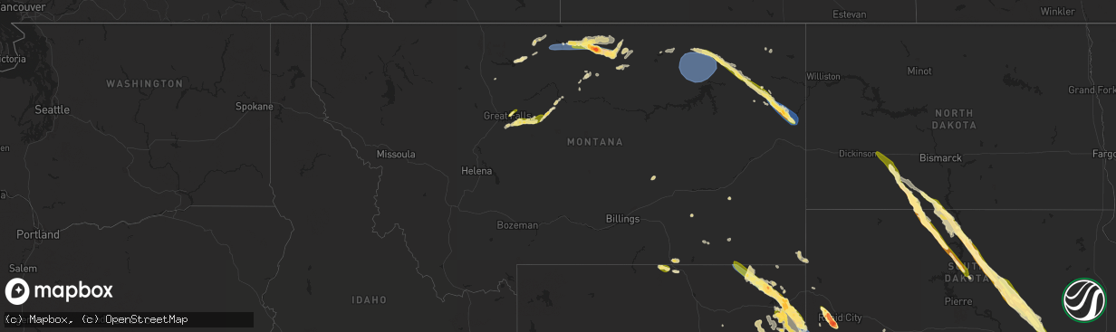
Hail Map in Montana on July 30, 2023
The weather event in Montana on July 30, 2023 includes Wind and Hail maps. 17 states and 1,033 cities were impacted and suffered possible damage. The total estimated number of properties impacted is 10,561.
Want more than just the map?
Turn this storm into a full workflow.
- Owner + property data so you know who to knock
- OnDemand branded weather history reports to win the "did we even have hail?" argument
- RoofTrace estimate so reps stop guessing numbers at the door
Bought this map? Upgrade within 7 days and we'll credit the $230. (10-15 min setup call)
Wind
Hail
10,561
Estimated number of impacted properties by a 1.00" hail or larger1,980
Estimated number of impacted properties by a 1.75" hail or larger1,261
Estimated number of impacted properties by a 2.50" hail or largerStorm reports in Montana
Montana
| Date | Description |
|---|---|
| 07/30/20236:20 PM CDT | Several large trees |
| 07/30/20236:20 PM CDT | 6 to 10 inch russian olive tree snapped at the base of the trunk. |
| 07/30/20236:19 PM CDT | Corrects previous tstm wnd gst report from 3 e wolf point. This was the latest observation before instrument failed. |
| 07/30/20236:16 PM CDT | Facebook report. |
| 07/30/20236:15 PM CDT | Power poles... Trees reported to be knocked down. A crosswalk light near the northside elementary school has been blown over. Facebook report with time estimated from r |
| 07/30/20236:15 PM CDT | Power poles and trees reported to be knocked down... Cross walk light near northside elementary school has been blown over. Facebook report. Time estimated from radar. |
| 07/30/20236:10 PM CDT | Hardcover of pickup bed lifted into back window causing damage... Estimated gust 80 mph. |
| 07/30/20236:10 PM CDT | Corrects previous tstm wnd dmg report from 1 w wolf point. Hardcover of pickup bed lifted into back window causing damage... Estimated gust 90 mph. |
| 07/30/20235:40 PM CDT | Facebook report. |
| 07/30/20235:35 PM CDT | House siding blown off. Tree wind break blown away. |
| 07/30/20235:34 PM CDT | Davis weather station recorded a 63 mph wind gust. Spotter also reported dime size hail. |
| 07/30/20235:19 PM CDT | This was the latest observation before instrument failed. |
| 07/30/20235:10 PM CDT | Mesonet observation. |
| 07/30/20231:01 AM CDT | Some of the damage that the spotter observed: a lid on a grain bin was blown away. Some trees down. At a nearby school... The flat top roof was lifted off the building. |
| 07/30/202312:33 AM CDT | Asos station kggw glasgow airport |
| 07/30/202312:30 AM CDT | A local report indicates 62 MPH wind near Saint Marie |
| 07/29/202310:19 PM CDT | Started hailing around 905 pm and just ended. Hail is covering the ground. It started as pea to dime size after 5 minutes... But it became larger after then. Most stone |
| 07/29/202310:09 PM CDT | Photos submitted of hail in harlem. |
| 07/29/20239:36 PM CDT | Public submitted of hail being measured with ruler and also compared to coins. |
| 07/29/20239:28 PM CDT | Photos submitted of large hail in chinook. |
| 07/29/20239:25 PM CDT | Spotter just arrived in town and estimates that the hail ended approximately 10 minutes ago... But there were still a few quarter size hailstones on the ground. |
| 07/29/20239:20 PM CDT | Blaine county deputy em reported golf ball size hail at their property. |
| 07/29/20239:08 PM CDT | Corrected report to reflect time of actual hail occurrence. Spotter just arrived in town and estimates that the hail ended approximately 10 minutes ago... But there wer |
| 07/29/20238:48 PM CDT | Report from mping: quarter |
| 07/29/20238:20 PM CDT | Recorded by automated weather observing system on southeast end of fresno reservoir. |
| 07/29/20238:15 PM CDT | 1.85-2 inches of rain... Quarter to ping pong size hail... Wind speeds of 60+ mph. |
| 07/29/20238:15 PM CDT | 1.85-2 rain... Quarter to ping pong size hail... Wind speeds of 60+ mph. |
| 07/29/20238:00 PM CDT | Estimated wind gusts of 50 to 60 mph. |
| 07/29/20237:15 PM CDT | Also... Neighbors horse trailer was blown over. |
All States Impacted by Hail Map on July 30, 2023
Cities Impacted by Hail Map on July 30, 2023
- Pueblo, CO
- Penrose, CO
- Beulah, CO
- Rye, CO
- Avondale, CO
- Colorado City, CO
- Wetmore, CO
- Carson, ND
- Elgin, ND
- Flasher, ND
- Selfridge, ND
- Fort Yates, ND
- New Leipzig, ND
- Hebron, ND
- Glen Ullin, ND
- Richardton, ND
- Shields, ND
- McLaughlin, SD
- Wakpala, SD
- Fairfield, NE
- Glenvil, NE
- Deweese, NE
- McIntosh, SD
- Glenham, SD
- Mobridge, SD
- Mound City, SD
- Selby, SD
- Akaska, SD
- Trail City, SD
- Glencross, SD
- Timber Lake, SD
- Eagle Butte, SD
- Gettysburg, SD
- Hoven, SD
- Lebanon, SD
- Miller, SD
- Ree Heights, SD
- Highmore, SD
- Saint Lawrence, SD
- Wessington, SD
- Wessington Springs, SD
- Onida, SD
- Seneca, SD
- Alpena, SD
- Plankinton, SD
- Woonsocket, SD
- Letcher, SD
- Mount Vernon, SD
- Mitchell, SD
- Holabird, SD
- Agar, SD
- Inland, NE
- Winner, SD
- Colome, SD
- Hayden, AL
- Hastings, NE
- Clay Center, NE
- Taylor, ND
- Alabaster, AL
- Helena, AL
- Adamsville, AL
- Mulga, AL
- Bessemer, AL
- Quinton, AL
- Pelham, AL
- Raleigh, ND
- Bullhead, SD
- Brookwood, AL
- Dora, AL
- Bremen, AL
- Empire, AL
- Jasper, AL
- Rockford, AL
- Armour, SD
- Delmont, SD
- Tripp, SD
- Deadwood, SD
- Nemo, SD
- Rapid City, SD
- Hill City, SD
- Parkman, WY
- Dayton, WY
- Wisner, NE
- Pender, NE
- Wakefield, NE
- Emerson, NE
- Thurston, NE
- Madison, NE
- Creston, NE
- Tyndall, SD
- Avon, SD
- Keystone, SD
- Ranchester, WY
- Wolf, WY
- Granite Canon, WY
- Bancroft, NE
- Rosalie, NE
- Lyons, NE
- Stanton, NE
- Leigh, NE
- Prague, NE
- Malmo, NE
- Larslan, MT
- Cheyenne, WY
- Lindsay, NE
- Humphrey, NE
- Missouri Valley, IA
- Honey Creek, IA
- Nashua, MT
- Frazer, MT
- Wolf Point, MT
- Jacksonville, FL
- Jacksonville Beach, FL
- Wheatland, WY
- Manville, WY
- Broadus, MT
- Weston, WY
- Recluse, WY
- Gillette, WY
- Sterling, CO
- Atwood, CO
- Bailey, MS
- Meridian, MS
- Enterprise, MS
- Eclectic, AL
- Tallassee, AL
- Berryville, AR
- Eureka Springs, AR
- Clarkson, NE
- Wellington, CO
- Omaha, NE
- Lance Creek, WY
- Buford, WY
- Moorcroft, WY
- Amity, AR
- Akron, AL
- Roanoke, AL
- Marion, AL
- Greensboro, AL
- Forest, MS
- Lena, MS
- Wray, GA
- Broxton, GA
- Fitzgerald, GA
- Lumpkin, GA
- Wyola, MT
- Jeffersonville, GA
- Dry Branch, GA
- Eufaula, AL
- Adrian, GA
- Kite, GA
- Faunsdale, AL
- Newbern, AL
- Vance, AL
- Philadelphia, MS
- Union, MS
- Walnut Grove, MS
- Oakland, NE
- Craig, NE
- Blair, NE
- Marion, MS
- Livermore, CO
- Tie Siding, WY
- Lauderdale, MS
- Daleville, MS
- Toomsuba, MS
- Porterville, MS
- De Kalb, MS
- Scotland, SD
- Tabor, SD
- Conehatta, MS
- Decatur, MS
- Notasulga, AL
- Platte Center, NE
- Papillion, NE
- Glasgow, MT
- Edgefield, SC
- Hawkinsville, GA
- Petersburg, NE
- Schuyler, NE
- Newman Grove, NE
- Tilden, NE
- Arabi, GA
- Cordele, GA
- Council Bluffs, IA
- Underwood, IA
- Modale, IA
- Crescent, IA
- Ormond Beach, FL
- Yankton, SD
- Brent, AL
- Forsyth, MT
- Lead, SD
- Otoe, NE
- Avoca, NE
- Valdosta, GA
- Quitman, GA
- Monticello, AR
- Little Rock, MS
- Sparta, GA
- Willacoochee, GA
- Preston, GA
- Plains, GA
- Sawyerville, AL
- Morse Bluff, NE
- Abbeville, AL
- Tallahassee, FL
- Thomaston, AL
- Murdock, NE
- Rochelle, GA
- Pitts, GA
- Baxley, GA
- Alamo, GA
- Glenwood, GA
- Coolidge, GA
- Pavo, GA
- Centreville, AL
- Weston, NE
- Eagle Rock, MO
- Seligman, MO
- Cassville, MO
- Yutan, NE
- Ashland, NE
- Forkland, AL
- Dublin, GA
- Duncanville, AL
- Cottondale, AL
- Cobb, GA
- Dunbar, NE
- Nebraska City, NE
- Altoona, FL
- Soperton, GA
- Pinetta, FL
- Mauk, GA
- Junction City, GA
- Tekamah, NE
- Allen, NE
- Concord, NE
- Decatur, NE
- Dodge, NE
- Milledgeville, GA
- Eatonton, GA
- Union, NE
- Americus, GA
- Buena Vista, GA
- Ellaville, GA
- Ash Fork, AZ
- Bluffton, GA
- Arlington, GA
- Glen Saint Mary, FL
- Macclenny, FL
- Crawfordville, FL
- Adger, AL
- Mead, NE
- Colon, NE
- Wahoo, NE
- Cuba, AL
- Ward, AL
- Lisman, AL
- Rhine, GA
- Gainesville, AL
- Epes, AL
- Fairview, MO
- Stark City, MO
- Chunky, MS
- Collinsville, MS
- Denton, GA
- Mobile, AL
- Springfield, NE
- Gretna, NE
- Damascus, GA
- Ithaca, NE
- Ocala, FL
- East Dublin, GA
- Winnebago, NE
- Ames, NE
- Oakfield, GA
- Monroe, NE
- Moundville, AL
- Cochran, GA
- McCalla, AL
- Granby, MO
- Neosho, MO
- Neptune Beach, FL
- Columbus, GA
- Johnston, SC
- Trenton, SC
- Waycross, GA
- Leslie, GA
- Bruno, NE
- Sopchoppy, FL
- Hosford, FL
- Folkston, GA
- South Bend, NE
- Weeping Water, NE
- Greenwood, NE
- Louisville, NE
- Waterloo, NE
- Cedar Bluffs, NE
- Morgan, GA
- Warwick, GA
- Abie, NE
- Manley, NE
- Elkhorn, NE
- David City, NE
- Nehawka, NE
- Columbus, NE
- Linwood, NE
- Fremont, NE
- Bellwood, NE
- Elmwood, NE
- Alvo, NE
- Howells, NE
- Fordyce, NE
- Crofton, NE
- Rock Port, MO
- Gann Valley, SD
- Utica, SD
- Lesterville, SD
- Milan, GA
- Jacksonville, GA
- Carthage, MS
- Golden, MO
- Vida, MT
- Richey, MT
- Poplar, MT
- Hulett, WY
- Hebron, NE
- Deshler, NE
- Chester, NE
- Hubbell, NE
- Belleville, KS
- Munden, KS
- Byron, NE
- Ellsworth, NE
- Lakeside, NE
- Oshkosh, NE
- Alliance, NE
- Snyder, CO
- Sundance, WY
- Upton, WY
- Newcastle, WY
- Osage, WY
- Berryton, KS
- Lecompton, KS
- Tecumseh, KS
- Lawrence, KS
- Eudora, KS
- Overbrook, KS
- Baldwin City, KS
- Ottawa, KS
- Pomona, KS
- Topeka, KS
- Lyndon, KS
- Quenemo, KS
- Scranton, KS
- Carbondale, KS
- Wakarusa, KS
- Vassar, KS
- Agenda, KS
- Narka, KS
- Cuba, KS
- Aurora, KS
- Concordia, KS
- Bridgeport, NE
- Platte City, MO
- Farley, MO
- Leavenworth, KS
- Liberty, MO
- Fort Leavenworth, KS
- Smithville, MO
- Kansas City, KS
- Lansing, KS
- Tonganoxie, KS
- Kansas City, MO
- Easton, KS
- Waldron, MO
- Basehor, KS
- Weston, MO
- Odessa, MO
- Orrick, MO
- Camden Point, MO
- Kearney, MO
- Sibley, MO
- Grain Valley, MO
- Blue Springs, MO
- Wellington, MO
- Missouri City, MO
- Independence, MO
- Levasy, MO
- Bates City, MO
- Oak Grove, MO
- Buckner, MO
- Napoleon, MO
- Riverside, MO
- Excelsior Springs, MO
- Bonner Springs, KS
- Leawood, KS
- Overland Park, KS
- Lees Summit, MO
- Prairie Village, KS
- Lenexa, KS
- Shawnee, KS
- Mission, KS
- Edgerton, MO
- Grandview, MO
- Atchison, KS
- Edgerton, KS
- Gardner, KS
- Garnett, KS
- Williamsburg, KS
- Wellsville, KS
- Richmond, KS
- Rantoul, KS
- Greeley, KS
- Melvern, KS
- Princeton, KS
- Spring Hill, KS
- Westphalia, KS
- Osawatomie, KS
- Lane, KS
- Paola, KS
- Waverly, KS
- Edgemont, SD
- Harrison, NE
- Lambert, MT
- Savage, MT
- Bloomfield, MT
- Great Falls, MT
- Stockett, MT
- Belt, MT
- Sand Coulee, MT
- Gildford, MT
- Kremlin, MT
- Havre, MT
- Chinook, MT
- Lisco, NE
- Kyle, SD
- Merriman, NE
- Tuthill, SD
- Martin, SD
- Reading, KS
- Admire, KS
- Emporia, KS
- Neosho Rapids, KS
- Lebo, KS
- Hartford, KS
- Burlington, KS
- Osage City, KS
- Lone Jack, MO
- Centerview, MO
- Pleasant Hill, MO
- Greenwood, MO
- Warrensburg, MO
- Holden, MO
- Kingsville, MO
- Leeton, MO
- Strasburg, MO
- Raymore, MO
- Chilhowee, MO
- Cleveland, MO
- Garden City, MO
- Harrisonville, MO
- Adrian, MO
- Urich, MO
- Archie, MO
- Belton, MO
- East Lynne, MO
- Clinton, MO
- Blairstown, MO
- Butler, MO
- Freeman, MO
- Peculiar, MO
- Drexel, MO
- Creighton, MO
- Stilwell, KS
- Olathe, KS
- De Soto, KS
- Linwood, KS
- Bucyrus, KS
- Louisburg, KS
- La Cygne, KS
- Amoret, MO
- Amsterdam, MO
- Mound City, KS
- Welda, KS
- Parker, KS
- Centerville, KS
- Fontana, KS
- Pleasanton, KS
- Mapleton, KS
- Uniontown, KS
- Fulton, KS
- Prescott, KS
- Hume, MO
- Bronson, KS
- Foster, MO
- Colony, KS
- Blue Mound, KS
- Kincaid, KS
- La Harpe, KS
- Moran, KS
- Montrose, MO
- Appleton City, MO
- Quincy, MO
- Warsaw, MO
- Osceola, MO
- Deepwater, MO
- Calhoun, MO
- Lowry City, MO
- Schell City, MO
- Rockville, MO
- El Dorado Springs, MO
- Walker, MO
- Richards, MO
- Fort Scott, KS
- Rich Hill, MO
- Nevada, MO
- Harwood, MO
- Redfield, KS
- Farlington, KS
- Arcadia, KS
- Moundville, MO
- Arma, KS
- Hepler, KS
- Bronaugh, MO
- Deerfield, MO
- Girard, KS
- Garland, KS
- Milo, MO
- Liberal, MO
- Gridley, KS
- Le Roy, KS
- Neosho Falls, KS
- Custer, SD
- Owanka, SD
- Wall, SD
- Wasta, SD
- Pine Ridge, SD
- Batesland, SD
- Wounded Knee, SD
- Gordon, NE
- Porcupine, SD
- Geyser, MT
- Raynesford, MT
- Highwood, MT
- Zurich, MT
- Harlem, MT
- Hays, MT
- Lamar, MO
- Wheatland, MO
- Sheldon, MO
- Flemington, MO
- Humansville, MO
- Weaubleau, MO
- Stockton, MO
- Mulberry, KS
- Hermitage, MO
- Pittsburg, MO
- Jerico Springs, MO
- Collins, MO
- Polk, MO
- Louisburg, MO
- Buffalo, MO
- Half Way, MO
- Long Lane, MO
- Bolivar, MO
- Dunnegan, MO
- Phillipsburg, MO
- Fair Play, MO
- Dadeville, MO
- Lockwood, MO
- Arcola, MO
- Aldrich, MO
- Mindenmines, MO
- Franklin, KS
- Elkland, MO
- Greenfield, MO
- Conway, MO
- Pittsburg, KS
- Joplin, MO
- Clever, MO
- Reeds, MO
- Walnut Grove, MO
- Opolis, KS
- Billings, MO
- Butterfield, MO
- Sarcoxie, MO
- Willard, MO
- La Russell, MO
- Marionville, MO
- Diamond, MO
- Bois D Arc, MO
- Crane, MO
- Asbury, MO
- Stotts City, MO
- Purdy, MO
- Ash Grove, MO
- Carthage, MO
- Wheaton, MO
- Pleasant Hope, MO
- Verona, MO
- Monett, MO
- Jasper, MO
- Miller, MO
- Webb City, MO
- Wentworth, MO
- Aurora, MO
- Mount Vernon, MO
- Freistatt, MO
- Carterville, MO
- Springfield, MO
- Avilla, MO
- Republic, MO
- Oronogo, MO
- South Greenfield, MO
- Purcell, MO
- Neck City, MO
- Brighton, MO
- Fair Grove, MO
- Golden City, MO
- Carl Junction, MO
- Alba, MO
- Halltown, MO
- Exeter, MO
- Morrisville, MO
- Everton, MO
- Brookline, MO
- Pierce City, MO
- Frontenac, KS
- Marshfield, MO
- Strafford, MO
- Duenweg, MO
- Rocky Comfort, MO
- Stella, MO
- Weir, KS
- Galena, KS
- Scammon, KS
- Urbana, MO
- Hot Springs, SD
- Crete, NE
- Hallam, NE
- Rudyard, MT
- Burlingame, KS
- Cortland, NE
- Adams, NE
- Volborg, MT
- Scandia, KS
- Lusk, WY
- Jamestown, KS
- Supai, AZ
- Williams, AZ
- Louin, MS
- Bay Springs, MS
- Saint George, GA
- Bonifay, FL
- Green Forest, AR
- Alpena, AR
- Joplin, MT
- Chester, MT
- Crystal River, FL
- Maitland, MO
- Mound City, MO
- Fort Calhoun, NE
- Alford, FL
- Cottondale, FL
- Harrison, AR
- Wrightsville, GA
- Rockledge, GA
- Girard, GA
- Silver Lake, KS
- Rossville, KS
- Maple Hill, KS
- Saint Marys, KS
- Vendor, AR
- Birney, MT
- Beloit, KS
- Glen Elder, KS
- Barnard, KS
- Cleveland, AR
- Hattieville, AR
- Clinton, AR
- Center Ridge, AR
- Jerusalem, AR
- Fairburn, SD
- Bamberg, SC
- Denmark, SC
- Allen, KS
- Merino, CO
- Devils Tower, WY
- Brewton, AL
- Geraldine, MT
- Robertsdale, AL
- Thomasville, GA
- Lost Springs, WY
- Shawnee, WY
- Clarkdale, AZ
- Jerome, AZ
- Avon Park, FL
- Patterson, GA
- Blackshear, GA
- Easton, MO
- Sells, AZ
- Oregon, MO
- Marana, AZ
- Bogalusa, LA
- Carriere, MS
- Emelle, AL
- Portal, GA
- Ambrose, GA
- Marianna, FL
- Milford, NE
- Green Cove Springs, FL
- Rushville, NE
- Peru, NE
- Julian, NE
- Auburn, NE
- Talmage, NE
- Brock, NE
- Glendo, WY
- Belle Fourche, SD
- Natoma, KS
- Plainville, KS
- Buckatunna, MS
- Moselle, MS
- Seminary, MS
- Garrett, WY
- Pleasant Dale, NE
- Denton, NE
- Oral, SD
- Poplarville, MS
- Buffalo Gap, SD
- Crawford, NE
- Walterboro, SC
- Chalmette, LA
- Violet, LA
- New Orleans, LA
- Meraux, LA
- Sanderson, FL
- Hector, AR
- Pelsor, AR
- Witts Springs, AR
- Mount Judea, AR
- Defuniak Springs, FL
- Surrency, GA
- Odum, GA
- Bristol, GA
- Shell Knob, MO
- Loranger, LA
- Rose Hill, MS
- Quitman, MS
- Pachuta, MS
- Vossburg, MS
- Paulding, MS
- Clifton, KS
- Clyde, KS
- Lame Deer, MT
- Fargo, GA
- Fort McCoy, FL
- Torrington, WY
- Alzada, MT
- Theodore, AL
- Clermont, FL
- Lawrence, MS
- Raleigh, MS
- Huntsville, AR
- Bartow, GA
- Delia, KS
- Picayune, MS
- Bishopville, SC
- Brownville, NE
- Nemaha, NE
- Hickory, MS
- Allen, SD
- Soso, MS
- Ellisville, MS
- Big Sandy, MT
- Hemingford, NE
- Otter, MT
- Stonewall, MS
- Inverness, MT
- Millen, GA
- Garfield, GA
- Atlantic Beach, FL
- Ponte Vedra Beach, FL
- Perkinston, MS
- Saucier, MS
- Kiln, MS
- Pass Christian, MS
- Spearfish, SD
- Grand Bay, AL
- Irvington, AL
- Moss Point, MS
- Statesboro, GA
- Grover, CO
- Watson, MO
- Bingham, NE
- Aliceville, AL
- Kissimmee, FL
- Starke, FL
- Keystone Heights, FL
- Lawtey, FL
- Webb, AL
- Dothan, AL
- Cowarts, AL
- Verdon, NE
- Hamburg, IA
- Lorton, NE
- Falls City, NE
- Shubert, NE
- Stella, NE
- Johnson, NE
- Frostproof, FL
- Savannah, GA
- Heidelberg, MS
- Fairfax, MO
- Skidmore, MO
- Sebring, FL
- Marsland, NE
- Nalcrest, FL
- Lake Wales, FL
- Conrad, MT
- Brady, MT
- Riceboro, GA
- Sylvania, GA
- Morton, MS
- Pelahatchie, MS
- Saint Johns, FL
- Mershon, GA
- Hoboken, GA
- Savannah, MO
- Saint Joseph, MO
- Boys Town, NE
- Beverly Hills, FL
- Lecanto, FL
- Whigham, GA
- Waynesboro, MS
- Lake, MS
- Scenic, SD
- Fishtail, MT
- Emmett, KS
- Taylorsville, MS
- Shubuta, MS
- Livingston, AL
- Bayard, NE
- Hingham, MT
- Jachin, AL
- Martin, SC
- Jasper, AR
- Marble Falls, AR
- Newton, MS
- Clarksdale, MO
- Stewartsville, MO
- Hammond, LA
- Alma, GA
- Hazlehurst, GA
- Fairfax, SC
- Lodge, SC
- Smoaks, SC
- Compton, AR
- Collins, MS
- Kaycee, WY
- Pickrell, NE
- Hinsdale, MT
- Vandalia, MT
- Saint Marie, MT
- Fort Peck, MT
- Galena, MO
- Nixa, MO
- Rogersville, MO
- Fordland, MO
- Ozark, MO
- Sparta, MO
- Bruner, MO
- Niangua, MO
- Seymour, MO
- Highlandville, MO
- Spokane, MO
- Chestnutridge, MO
- Walnut Shade, MO
- Chadwick, MO
- Forsyth, MO
- Oldfield, MO
- Ponce De Leon, MO
- Ava, MO
- Reeds Spring, MO
- Cape Fair, MO
- Garrison, MO
- Kissee Mills, MO
- Lakeview, AR
- Powersite, MO
- Hollister, MO
- Thornfield, MO
- Wasola, MO
- Gainesville, MO
- Lampe, MO
- Theodosia, MO
- Protem, MO
- Peel, AR
- Gassville, AR
- Lead Hill, AR
- Yellville, AR
- Omaha, AR
- Blue Eye, MO
- Ridgedale, MO
- Branson, MO
- Midway, AR
- Kirbyville, MO
- Rockaway Beach, MO
- Rueter, MO
- Mountain Home, AR
- Bradleyville, MO
- Oakland, AR
- Cedarcreek, MO
- Bull Shoals, AR
- Squires, MO
- Noble, MO
- Isabella, MO
- Kimberling City, MO
- Pontiac, MO
- Taneyville, MO
- Cotter, AR
- Norfork, AR
- Flippin, AR
- Oak Grove, AR
- Summit, AR
- Everton, AR
- Saint Joe, AR
- Onia, AR
- Marshall, AR
- Pyatt, AR
- Valley Springs, AR
- Harriet, AR
- Leslie, AR
- Timbo, AR
- Big Flat, AR
- Gilbert, AR
- Pindall, AR
- Western Grove, AR
- Hasty, AR
- Washburn, MO
- Kingston, AR
- Deer, AR
- Parthenon, AR
- Ponca, AR
- Garfield, AR
- Rogers, AR
- Callaway, NE
- Calico Rock, AR
- Ashby, NE
- Everest, KS
- Interior, SD
- Humboldt, KS
- Erie, KS
- Savonburg, KS
- Chanute, KS
- Hartington, NE
- Lloyd, MT
- Guion, AR
- Angora, NE
- Hartman, AR
- Clarksville, AR
- Custer, MT
- Soldier, KS
- Havensville, KS
- Lewellen, NE
- Melbourne, AR
- Clatonia, NE
- Wilber, NE
- Wood River, NE
- Five Points, AL
- Loup City, NE
- Laurel, NE
- Brewster, NE
- Grand Island, NE
- Cairo, NE
- Shelton, NE
- Arthur, NE
- Virginia, NE
- Crab Orchard, NE
- Lewiston, NE
- Filley, NE
- Dorchester, NE
- Burchard, NE
- Steinauer, NE
- Elk Creek, NE
- Firth, NE
- Tecumseh, NE
- Ansley, NE
- Mountain View, AR
- Springfield, SD
- Ashton, NE
- Ravenna, NE
- Rockville, NE
- Tucson, AZ
- Sahuarita, AZ
- Hyannis, NE
- Saco, MT
- Batesville, AR
- Horton, KS
- Hiawatha, KS
- Stapleton, NE
- Brady, NE
- Arnold, NE
- Maxwell, NE
- Scotland, AR
- Martell, NE
- De Witt, NE
- Hay Springs, NE
- Broadwater, NE
- Virgil, SD
- Malta, MT
- Wellton, AZ
- Dover, AR
- Hogeland, MT
- Saint Edward, NE
- Holton, KS
- Mayetta, KS
- Camden, AL
- Merna, NE
- Brockton, MT
- Flaxville, MT
- Meadow Grove, NE
- Twin City, GA
- Memphis, NE
- Elgin, NE
- Oakdale, NE
- Battle Creek, NE
- Sumiton, AL
- Leary, GA
- North Bend, NE
- Wadley, GA
- Bastrop, LA


