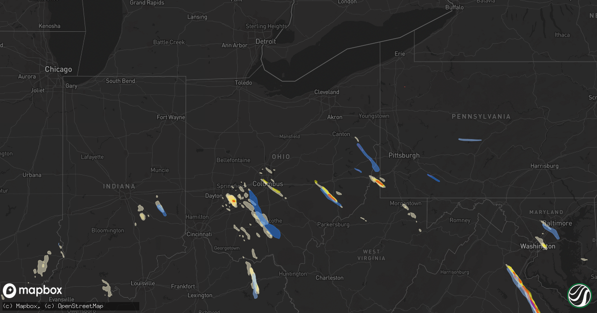
Hail Map in Ohio on July 29, 2021
Get this storm
July 29 map
$229
one time, instant access
Download today. No call, no setup
Keep the $229
Bought the map and want the full workflow? Apply the entire $229 to a subscription within 7 days. None of it is wasted.
Every map, not just this one
This buys you this map. Subscription and you get every map we run, in the markets you choose from a few cities to whole states to nationwide. Plus real-time alerts the moment a storm fires.
Contact data
Name, contact info, occupancy, even credit band for addresses in the footprint. You go from where it hit to who to call.
Become the source they trust
Unlimited branding weather history reports on demand. You already have the documented answer ready for the property owner, and you are the one who showed up with it.
Property data and RoofTrace estimates
Pull up any address you have got, its value and the exact code rules for that jurisdiction, straight from One Click Code. Then RoofTrace estimates the squares, pitch, and roof value, priced the way you price.
Storm reports in Ohio
Ohio
| Date | Description |
|---|---|
| 07/29/20216:15 PM CDT | A tree was reported down near davids drive and oh-134. Time estimated from radar. |
| 07/29/20215:47 PM CDT | Numerous trees downed near the intersection of smith road and zimmerman road. Time estimated from radar. |
| 07/29/20215:46 PM CDT | Trees reported down. Time estimated from radar. |
| 07/29/20215:14 PM CDT | Trees and power lines reported down. |
| 07/29/20215:08 PM CDT | Waynesville jamestown rd |
| 07/29/20215:07 PM CDT | Siding damage to house... 40-foot camper blown over |
| 07/29/20215:00 PM CDT | Trees snapped and a tree uprooted. |
| 07/29/20214:59 PM CDT | Tornado reported seen on the ground in new alexandria partially wrapped in rain bands. |
| 07/29/20214:50 PM CDT | Nws storm survey detected ef1 damage sw of wintersville... Oh... Where both hardwood and softwood trees were snapped... And damage to residential property and farm outb |
| 07/29/20214:50 PM CDT | Report of numerous trees down... Windows broken... Collapsed roof and home on bantam ridge in wintersville. |
| 07/29/20214:49 PM CDT | Some power lines reported down near u.s. 42 and james barber road. Time estimated from radar. |
| 07/29/20214:48 PM CDT | Large tree limb down on garage |
| 07/29/20214:46 PM CDT | Tree down |
| 07/29/20214:42 PM CDT | A barn is destroyed and a number of trees are down across the village. |
| 07/29/20214:40 PM CDT | Widespread damage with utility lines and trees down being reported across jefferson county... Oh. |
| 07/29/20214:28 PM CDT | A tree was reported down on kirkwood heights rd. |
| 07/29/20214:22 PM CDT | One tree downed along us route 22. |
| 07/29/20214:21 PM CDT | Several large tree limbs snapped along us route 22. |
| 07/29/20214:20 PM CDT | Nws survey team identified ef1 tornado damage along tr 276 where multiple hardwood trees were leveled north of berkholz cemetery and west of the town of berkholz. |
| 07/29/20214:20 PM CDT | Brief ef0 tornado confirmed near new holland in pickaway county ohio. |
| 07/29/20214:17 PM CDT | Multiple trees down on us-62n. Time est from radar. |
| 07/29/20214:16 PM CDT | Video of apparent tornado touchdown near i-77 along with tree damage near intersection of highland ridge rd and cats creek rd. |
| 07/29/20214:15 PM CDT | Nws storm survey team detected ef0 tornado damage along tr 263 where hardwood trees were uprooted. Time based on radar. |
| 07/29/20214:09 PM CDT | Nws storm survey team detected ef0 tornado damage along parma rd se... Where 1-3 inch diameter hardwood tree branches were broken. |
| 07/29/20214:08 PM CDT | A local report indicates 1.50 inch wind near 1 NNW SOUTH OLIVE |
| 07/29/20214:06 PM CDT | Trees and utility poles down along state route 39 |
| 07/29/20214:05 PM CDT | Report of trees down and a neighbor's machinery shed destroyed in washingtown township. |
| 07/29/20214:04 PM CDT | 20x30ft shed destroyed and chimney blown off house near 3100 channel road. |
| 07/29/20214:02 PM CDT | Nws storm survey team detected efo tornado damage along channel rd ne where structural damage to farm outbuildings and residential property occured. Time estimate based |
| 07/29/20213:59 PM CDT | Multiple reports of trees and power lines reported down. Time estimated from radar. |
| 07/29/20213:57 PM CDT | Nws survey team detected ef1 tornado damage east of new athens... Oh where electrical transmission lines were snapped... Hardwood trees uprooted and snapped... And stru |
| 07/29/20213:55 PM CDT | Nws survey team observed ef2 tornado damage in the town of new athens... Oh... Where damage to residential structures was observed. Hardwood trees were snapped or uproo |
| 07/29/20213:55 PM CDT | A few trees down. |
| 07/29/20213:55 PM CDT | Tornado spotted heading from new athens toward harrisville. Report of a house out in the road in new athens. |
| 07/29/20213:50 PM CDT | Picture of quarter to golf ball size hail east of caldwell. Time estimated based on radar. |
| 07/29/20213:50 PM CDT | Nws survey team detected ef1 tornado damage along webb road in new athens... Oh where softwood trees were uprooted and snapped. Time estimated based on radar. |
| 07/29/20213:01 PM CDT | Multiple trees downed on dyer rd in mt. Sterling. Garage door was also blown in and damaged. |
| 07/29/20212:49 PM CDT | Large tree limb down |
| 07/29/20212:44 PM CDT | Numerous trees downed near the intersection of s old state road and hollenback road. Time estimated from radar. |
| 07/29/20212:42 PM CDT | A local report indicates 1.00 inch wind near 3 SW PICKERINGTON |
| 07/29/20212:32 PM CDT | Report of large tree down on hamby hill road. Time estimated based on radar. |
| 07/29/20212:32 PM CDT | Report of large tree down on hamby hill road. Time estimated based on radar. |
| 07/29/20212:13 PM CDT | Wires reported down and large tree branches reported down across the city. Time estimated from radar. |
| 07/29/20212:09 PM CDT | Multiple reports of quarter sized hai near short north and downtown columbus. |
| 07/29/20212:02 PM CDT | One healthy tree downed on summit street. Time estimated from radar. |
| 07/29/202110:48 AM CDT | Roof blown off of a barn... Along with several small trees blown over on perry rd. Additional tree damage occurred on giddings rd. |
| 07/29/202110:47 AM CDT | Tree and wires down. |
| 07/29/202110:37 AM CDT | Numerous trees down throughout kingsville. |
| 07/29/202110:36 AM CDT | Corrects previous tstm wnd dmg report from 2 sw north kingsville. Tree and wires down. |
| 07/29/202110:36 AM CDT | A local report indicates 59 MPH wind near 4 W ASHTABULA |
| 07/29/20215:47 AM CDT | At 1046 AM EDT, a severe thunderstorm was located near Geneva-On-The-Lake, moving east at 30 mph. HAZARD...60 mph wind gusts. SOURCE...Radar indicated. IMPACT...Expect damage to trees and power lines. Locations impacted include... Ashtabula, Conneaut, Geneva-On-The-Lake, Geneva, Madison, North Kingsville, Perry, Austinburg, Kingsville, Pierpont, North Perry, Edgewood, Plymouth Center, North Madison and Kelloggsville. |
| 07/29/20214:42 AM CDT | At 942 PM EDT, a severe thunderstorm was located 4 miles south of Vanceburg, moving southeast at 35 mph. HAZARD...60 mph wind gusts and quarter size hail. SOURCE...Radar indicated. IMPACT...Minor hail damage to vehicles is possible. Expect wind damage to trees and power lines. Locations impacted include... Vanceburg, Head of Grassy, Camp Dix, Harris, Kinniconick, Tannery, Emerson, Ribolt, Charters, Petersville, Stricklett, Glen Springs and Herron Hill. |
| 07/29/20213:36 AM CDT | At 836 PM EDT, a severe thunderstorm was located 8 miles northeast of Vanceburg, moving southeast at 30 mph. HAZARD...60 mph wind gusts and nickel size hail. SOURCE...Radar indicated. IMPACT...Expect damage to trees and power lines. Locations impacted include... Portsmouth, Vanceburg, Camp Dix, Rome, Sandy Springs, Buena Vista in Scioto County, Saint Paul, Firebrick, West Portsmouth, Tannery, Turkey Creek Lake, Friendship, Garrison and Rexton. |
| 07/29/20211:36 AM CDT | At 635 PM EDT, a severe thunderstorm was located over Cadiz, moving southeast at 25 mph. HAZARD...Wind gusts to 60 mph and quarter-size hail. SOURCE...Radar. IMPACT...Minor hail damage to vehicles is possible. Expect wind damage to trees and power lines, resulting in some power outages. Locations impacted include... Cadiz... Hopedale... Smithfield... Adena... Jewett... Dillonvale... Mount Pleasant... New Athens... Harrisville... Newell... |
| 07/29/20211:13 AM CDT | At 613 PM EDT, a severe thunderstorm was located over Jamestown, moving southeast at 25 mph. HAZARD...60 mph wind gusts and quarter size hail. SOURCE...Radar indicated. IMPACT...Minor hail damage to vehicles is possible. Expect wind damage to trees and power lines. Locations impacted include... Washington Court House, Wilmington, Sabina, Jamestown, New Jasper, Staunton, Bowersville, Port William, Milledgeville, Octa, Paintersville, Melvin, Rosemoor, Bloomington, Jasper Mills, Lees Creek, Reesville, Bell Center, Interstate 71 at US Route 35 and New Antioch.This includes I-71 in Ohio between mile markers 53 and 67. |
| 07/29/20211:07 AM CDT | At 607 AM EDT, severe thunderstorms were located along a line extending from near Butler to near Grabill to near Fort Wayne, moving east at 50 mph. HAZARD...60 mph wind gusts. SOURCE...Radar indicated. IMPACT...Expect damage to roofs, siding, and trees. Locations impacted include... Fort Wayne, Defiance, New Haven, Auburn, Hicksville, Butler, Paulding, Waterloo, Antwerp, Hamilton, Woodburn, Monroeville, Payne, Continental, Convoy, Grabill, Ottoville, St. Joe, Oakwood and Leo-cedarville.This includes the following highways... Interstate 469 between mile markers 5 and 6, and between milemarkers 9 and 30. Interstate 69 in Indiana between mile markers 297 and 323. |
| 07/29/202112:58 AM CDT | At 557 PM EDT, a severe thunderstorm was located near Chillicothe, moving southeast at 35 mph. HAZARD...70 mph wind gusts and quarter size hail. SOURCE...Radar indicated. IMPACT...Minor hail damage to vehicles is possible. Expect considerable tree damage. Wind damage is also likely to mobile homes, roofs, and outbuildings. Locations impacted include... Waverly, Piketon, Bainbridge, Pike Lake, Kincaid Springs, Lucasville, Londonderry, Beaver, South Salem, Rarden, Wakefield, Pike County Airport, Mooresville, Omega, Givens, Knockemstiff, Mount Joy, Bear Creek and Massieville. |
| 07/29/202112:37 AM CDT | At 537 PM EDT, a severe thunderstorm was located 8 miles northwest of Woodsfield, moving southeast at 30 mph. HAZARD...Wind gusts to 60 mph and quarter-size hail. SOURCE...Radar. IMPACT...Minor hail damage to vehicles is possible. Expect wind damage to trees and power lines, resulting in some power outages. Locations impacted include... Woodsfield... Beallsville... Clarington... Lewisville... Jerusalem... Wilson... Cameron... Antioch... Graysville... Batesville... Miltonsburg... Laings... |
| 07/29/202112:25 AM CDT | At 525 AM EDT, severe thunderstorms were located along a line extending from near Ligonier to near Syracuse to near North Webster, moving east at 55 mph. HAZARD...60 mph wind gusts. SOURCE...Radar indicated. IMPACT...Expect damage to roofs, siding, and trees. Locations impacted include... Fort Wayne, Warsaw, Auburn, Kendallville, Garrett, Winona Lake, Ligonier, Butler, Tri-lakes, Huntertown, Avilla, Albion, Waterloo, Churubusco, Hamilton, Woodburn, Rome City, North Webster, Grabill and St. Joe.This includes the following highways... Interstate 469 between mile markers 25 and 30. Interstate 69 in Indiana between mile markers 314 and 340. |
| 07/29/202112:24 AM CDT | At 524 PM EDT, a severe thunderstorm was located over Martins Ferry, moving southeast at 35 mph. HAZARD...Wind gusts to 60 mph and quarter-size hail. SOURCE...Radar. IMPACT...Minor hail damage to vehicles is possible. Expect wind damage to trees and power lines, resulting in some power outages. Locations impacted include... Wheeling... Martins Ferry... Bellaire... Warwood... Bethlehem... Triadelphia... Clearview... Valley Grove... McMechen... Tiltonsville... Cameron... Bridgeport...This includes the following highways... Interstate 70 in Ohio between mile markers 221 and 225. Interstate 70 in West Virginia between mile markers 0 and 14. Interstate 70 in Pennsylvania near mile marker 0. |
| 07/29/202112:24 AM CDT | At 524 PM EDT, a severe thunderstorm was located near New Holland, moving southeast at 35 mph. HAZARD...70 mph wind gusts and quarter size hail. SOURCE...Radar indicated. IMPACT...Minor hail damage to vehicles is possible. Expect considerable tree damage. Wind damage is also likely to mobile homes, roofs, and outbuildings. Locations impacted include... Chillicothe, Washington Court House, Greenfield, Leesburg, Kingston, Bainbridge, New Holland, North Folk Village, Staunton, Good Hope, Frankfort, Clarksburg, South Salem, East Monroe, Mooresville, Austin, Knockemstiff, Rock Mills, Massieville and New Martinsburg. |
| 07/29/202112:00 AM CDT | At 459 PM EDT, a severe thunderstorm was located near Mount Sterling, moving southeast at 50 mph. HAZARD...70 mph wind gusts and quarter size hail. SOURCE...Radar indicated. IMPACT...Minor hail damage to vehicles is possible. Expect considerable tree damage. Wind damage is also likely to mobile homes, roofs, and outbuildings. Locations impacted include... Washington Court House, Jeffersonville, Williamsport, Bloomingburg, New Holland, Staunton, Good Hope, Frankfort, Clarksburg, Milledgeville, Deer Creek Lake, Andersonville, Austin, Jasper Mills, Madison Mills, Pickaway County Airport, and Rock Mills.This includes I-71 in Ohio between mile markers 66 and 75. |
| 07/28/202111:55 PM CDT | At 454 PM EDT, a severe thunderstorm was located near Caldwell, moving southeast at 30 mph. This is a very dangerous storm. HAZARD...80 mph wind gusts and quarter size hail. SOURCE...Radar indicated. IMPACT...Flying debris will be dangerous to those caught without shelter. Mobile homes will be heavily damaged. Expect considerable damage to roofs, windows, and vehicles. Extensive tree damage and power outages are likely. Locations impacted include... Newport, Matamoras, Macksburg, Lower Salem and New Matamoras. This includes Interstate 77 in Ohio between mile markers 10 and 17. |
| 07/28/202111:54 PM CDT | At 454 PM EDT, a severe thunderstorm was located near Caldwell, moving southeast at 30 mph. HAZARD...Wind gusts to 60 mph and quarter-size hail. SOURCE...Radar. IMPACT...Minor hail damage to vehicles is possible. Expect wind damage to trees and power lines, resulting in some power outages. Locations impacted include... Caldwell... Dudley... Belle Valley... Dexter City... Harriettsville... Rinard Mills...This includes Interstate 77 in Ohio between mile markers 18 and 29. |
| 07/28/202111:48 PM CDT | At 448 PM EDT, a severe thunderstorm was located over Cadiz, moving southeast at 15 mph. HAZARD...Wind gusts to 60 mph and quarter-size hail. SOURCE...Radar. IMPACT...Minor hail damage to vehicles is possible. Expect wind damage to trees and power lines, resulting in some power outages. Locations impacted include... St. Clairsville... Cadiz... Flushing... Smithfield... Adena... Dillonvale... Mount Pleasant... New Athens... Harrisville... Newell...This includes Interstate 70 in Ohio between mile markers 215 and 218. |
| 07/28/202111:48 PM CDT | At 448 PM EDT, a severe thunderstorm was located near South Charleston, moving southeast at 20 mph. HAZARD...60 mph wind gusts and quarter size hail. SOURCE...Radar indicated. IMPACT...Minor hail damage to vehicles is possible. Expect wind damage to trees and power lines. Locations impacted include... London, South Charleston, Jeffersonville, Bloomingburg, Lisbon, South Solon, Midway, Newport, Chenoweth, Interstate 71 at State Route 38, Madison Mills and Bookwalter.This includes I-71 in Ohio between mile markers 68 and 80. |
| 07/28/202111:43 PM CDT | At 442 PM EDT, a severe thunderstorm was located 7 miles southeast of London, moving southeast at 20 mph. HAZARD...60 mph wind gusts and quarter size hail. SOURCE...Radar indicated. IMPACT...Minor hail damage to vehicles is possible. Expect wind damage to trees and power lines. Locations impacted include... Mount Sterling, Williamsport, Harrisburg, Newport, Deer Creek Lake, Chenoweth, Madison Mills, Derby, Big Plain, Pancoastburg and Wrightsville.This includes I-71 in Ohio between mile markers 78 and 91. |
| 07/28/202111:30 PM CDT | At 430 PM EDT, a severe thunderstorm was located near Minerva, or 14 miles southwest of Salem, moving southeast at 30 mph. HAZARD...Wind gusts to 60 mph. SOURCE...Radar. IMPACT...Expect damage to trees and power lines, resulting in some power outages. Locations impacted include... Minerva... Lisbon... Augusta... Salineville... Bergholz... Hanoverton... Irondale... Summitville... Mechanicstown... North Georgetown... Homeworth... Guilford Lake State Park... |
| 07/28/202111:24 PM CDT | At 424 PM EDT, a severe thunderstorm was located over Lancaster, moving southeast at 25 mph. HAZARD...60 mph wind gusts and quarter size hail. SOURCE...Radar indicated. IMPACT...Minor hail damage to vehicles is possible. Expect wind damage to trees and power lines. Locations impacted include... Lancaster, Logan, Nelsonville, Bremen, Pleasantville, Hide-A-Way Hills, Starr, Murray City, Sugar Grove, Rushville, West Rushville, US Route 22 at State Route 159, Hideaway Hills, Haydenville, Lake Logan State Park, North Berne, Enterprise, Union Furnace, Rockbridge and Oreville. |
| 07/28/202111:12 PM CDT | At 412 PM EDT, a severe thunderstorm was located 8 miles south of New Concord, or 13 miles east of Zanesville, moving southeast at 45 mph. HAZARD...Wind gusts to 60 mph and quarter-size hail. SOURCE...Radar. IMPACT...Minor hail damage to vehicles is possible. Expect wind damage to trees and power lines, resulting in some power outages. Locations impacted include... Caldwell... New Concord... Dudley... Cumberland... Belle Valley... Sarahsville... Dexter City... Norwich... High Hill... Chandlersville... Bridgeville... Duncan Falls...This includes the following highways... Interstate 70 in Ohio between mile markers 162 and 170. Interstate 77 in Ohio between mile markers 18 and 33. |
| 07/28/202110:57 PM CDT | At 357 PM EDT, a severe thunderstorm was located over Choctaw Lake, moving southeast at 35 mph. HAZARD...60 mph wind gusts and quarter size hail. SOURCE...Radar indicated. IMPACT...Minor hail damage to vehicles is possible. Expect wind damage to trees and power lines. Locations impacted include... London, Jefferson, West Jefferson, Mount Sterling, Choctaw Lake, Brighton, Lafayette, South Vienna, Catawba, Newport, Chenoweth, Lilly Chapel, Madison Lake, Plumwood, Big Plain and Wrightsville.This includes the following Interstates... I-70 in Ohio between mile markers 65 and 84. I-71 in Ohio between mile markers 80 and 87. |
| 07/28/202110:50 PM CDT | At 350 PM EDT, a severe thunderstorm was located over Canal Winchester, moving southeast at 20 mph. HAZARD...Ping pong ball size hail and 60 mph wind gusts. SOURCE...Radar indicated. IMPACT...People and animals outdoors will be injured. Expect hail damage to roofs, siding, windows, and vehicles. Expect wind damage to trees and power lines. Locations impacted include... Lancaster, Pickerington, Canal Winchester, Groveport, Baltimore, Bremen, Pleasantville, Hide-A-Way Hills, Royalton, Lithopolis, Carroll, Sugar Grove, Rushville, West Rushville, Fairfield County Airport, US Route 22 at State Route 159, Clearport, North Berne and Dumontville. |
| 07/28/202110:43 PM CDT | At 343 PM EDT, a severe thunderstorm was located over Powell, moving east at 45 mph. HAZARD...60 mph wind gusts and quarter size hail. SOURCE...Radar indicated. IMPACT...Minor hail damage to vehicles is possible. Expect wind damage to trees and power lines. Locations impacted include... Columbus, Dublin, Westerville, Reynoldsburg, Delaware, Upper Arlington, Gahanna, Hilliard, Worthington, Pataskala, Powell, Johnstown, Sunbury, Plain City, Minerva Park, New California, Polaris, Easton, Summit Station and Whitehall.This includes I-71 in Ohio between mile markers 111 and 132. |
| 07/28/202110:31 PM CDT | At 331 PM EDT, a severe thunderstorm was located near Frazeysburg, or 8 miles north of Zanesville, moving southeast at 30 mph. HAZARD...Wind gusts to 60 mph and quarter-size hail. SOURCE...Radar. IMPACT...Minor hail damage to vehicles is possible. Expect wind damage to trees and power lines, resulting in some power outages. Locations impacted include... Zanesville... Cambridge... New Concord... North Zanesville... Dresden... Frazeysburg... Pleasant Grove... Norwich... High Hill... Chandlersville... Bridgeville... Otsego...This includes the following highways... Interstate 70 in Ohio between mile markers 156 and 178. Interstate 77 in Ohio between mile markers 47 and 49. |
| 07/28/202110:13 PM CDT | At 313 PM EDT, a severe thunderstorm was located over Columbus, moving southeast at 25 mph. HAZARD...60 mph wind gusts and quarter size hail. SOURCE...Radar indicated. IMPACT...Minor hail damage to vehicles is possible. Expect wind damage to trees and power lines. Locations impacted include... Columbus, Reynoldsburg, Grove City, Upper Arlington, Pickerington, Bexley, Canal Winchester, Groveport, Ashville, Baltimore, Ohio State University, Whitehall, Grandview Heights, Obetz, Royalton, Lithopolis, Urbancrest, Valleyview, Marble Cliff and Carroll.This includes the following Interstates... I-70 in Ohio between mile markers 92 and 112. I-71 in Ohio between mile markers 100 and 114. |
| 07/28/20219:49 PM CDT | At 249 PM EDT, a severe thunderstorm was located over Powell, moving southeast at 40 mph. HAZARD...60 mph wind gusts. SOURCE...Radar indicated. IMPACT...Expect damage to trees and power lines. Locations impacted include... Columbus, Dublin, Westerville, Reynoldsburg, Upper Arlington, Gahanna, Hilliard, Pickerington, Worthington, Bexley, Pataskala, Powell, Canal Winchester, Minerva Park, Ohio State University, Beechwood Trails, Polaris, Easton, Summit Station and Granville South.This includes the following Interstates... I-70 in Ohio between mile markers 101 and 121. I-71 in Ohio between mile markers 108 and 125. |
| 07/28/20218:08 PM CDT | At 108 PM EDT, severe thunderstorms were located along a line extending from Pymatuning North to 6 miles northeast of Atlantic, moving southeast at 55 mph. HAZARD...60 mph wind gusts. SOURCE...Radar indicated. IMPACT...Expect damage to trees and power lines. Locations impacted include... Linesville, Harmonsburg, Pymatuning North, Atlantic, Adamsville, Pymatuning Central, Cochranton, Conneaut Lake, Conneaut Lakeshore, Geneva and Hartstown. |
| 07/28/20217:21 PM CDT | Multiple trees and power lines down in the northern part of the county including otway. Time estimated from radar. |
All States Impacted by Hail Map on July 29, 2021
Cities Impacted by Hail Map on July 29, 2021
- South Charleston, OH
- South Vienna, OH
- London, OH
- Meeker, CO
- Fieldon, IL
- Lebanon, IL
- Trenton, IL
- Highland, IL
- O'Fallon, IL
- Troy, IL
- Saint Jacob, IL
- Douglas, WY
- Cedarville, OH
- Xenia, OH
- Jamestown, OH
- Fenton, MO
- Imperial, MO
- Burtonsville, MD
- Laurel, MD
- South Solon, OH
- Jeffersonville, OH
- Payson, AZ
- Eureka, IL
- Wooton, KY
- Hazard, KY
- Casper, WY
- Evansville, WY
- West Finley, PA
- Wind Ridge, PA
- Cameron, WV
- Dallas, WV
- Wheeling, WV
- Clarkdale, AZ
- Prescott Valley, AZ
- Pinon, AZ
- Millstadt, IL
- Columbia, IL
- Ganado, AZ
- Winslow, AZ
- Teasdale, UT
- Hanksville, UT
- Somerset, CO
- Vanceburg, KY
- Emerson, KY
- Morehead, KY
- Olive Hill, KY
- Fredericksburg, VA
- Peebles, OH
- Hillsboro, OH
- Mancos, CO
- King William, VA
- West Point, VA
- Kaycee, WY
- Gillette, WY
- Lower Salem, OH
- Centennial, WY
- Walkerton, VA
- Kewanee, IL
- West Point, IA
- Washington, IL
- Sabina, OH
- Yellow Springs, OH
- Egnar, CO
- Mount Union, IA
- New London, IA
- Jackson, KY
- Clayhole, KY
- Vancleve, KY
- Lost Creek, KY
- Rousseau, KY
- Newcastle, WY
- Columbus, OH
- Flat Rock, IN
- Benton, IL
- Thompsonville, IL
- Dewey, AZ
- Minden, LA
- Hermann, MO
- Milford, VA
- Bowling Green, VA
- Port Royal, VA
- Woodford, VA
- Yates City, IL
- Williamsfield, IL
- Elmwood, IL
- Knoxville, IL
- Galesburg, IL
- Oneida, IL
- Gilson, IL
- Dahinda, IL
- Coalmont, CO
- Willcox, AZ
- Burlington, IA
- Mediapolis, IA
- Oquawka, IL
- Biggsville, IL
- Gladstone, IL
- Gypsum, CO
- Parachute, CO
- Canal Winchester, OH
- Groveport, OH
- Chinle, AZ
- Bladensburg, MD
- Brentwood, MD
- Riverdale, MD
- Hyattsville, MD
- District Heights, MD
- Capitol Heights, MD
- Washington, DC
- Mount Pleasant, IA
- Saint Stephens Church, VA
- Newtown, VA
- Mayer, AZ
- Humboldt, AZ
- Prescott, AZ
- Hilliard, OH
- Linn, MO
- Albion, IL
- Ellery, IL
- Mount Erie, IL
- West Salem, IL
- Parkersburg, IL
- Tappahannock, VA
- Cortez, CO
- Westerville, OH
- Lewis Center, OH
- Galena, OH
- Cairo, MO
- Rancocas, NJ
- Mount Holly, NJ
- Beverly, NJ
- Willingboro, NJ
- Caldwell, OH
- Glenwood, IN
- Rushville, IN
- Laurel, IN
- Maquon, IL
- Victoria, IL
- Claysville, PA
- West Alexander, PA
- Kaibeto, AZ
- Rowlesburg, WV
- Vincentown, NJ
- Pemberton, NJ
- East Saint Louis, IL
- Calhoun, IL
- Morgantown, WV
- Granite City, IL
- Muscatine, IA
- New Boston, IL
- Dolores, CO
- Glenrock, WY
- Dublin, OH
- Riverside, NJ
- Clifton Hill, MO
- Huntsville, MO
- Excello, MO
- Flagstaff, AZ
- Concho, AZ
- Sedona, AZ
- Aviston, IL
- Mascoutah, IL
- North Henderson, IL
- Batchtown, IL
- Hardin, IL
- Hamburg, IL
- Jerseyville, IL
- Jamesport, MO
- Dunlap, IL
- Chillicothe, IL
- Peoria, IL
- New Holland, OH
- Washington Court House, OH
- Beaver, UT
- Greenville, UT
- Columbia, MD
- Sykesville, MD
- Hanover, MD
- West Friendship, MD
- Ellicott City, MD
- Marriottsville, MD
- Elkridge, MD
- King City, MO
- McFall, MO
- Darlington, MO
- Springfield, OH
- Huntingdon Valley, PA
- Philadelphia, PA
- Feasterville Trevose, PA
- House Springs, MO
- Browns Mills, NJ
- Gueydan, LA
- Cahone, CO
- Goldvein, VA
- Midland, VA
- Grosse Tete, LA
- Toano, VA
- Williamsburg, VA
- Lanexa, VA
- Pleasant Hill, IL
- Corbin, KY
- Safford, AZ
- Chillicothe, OH
- Paris, MO
- Mount Laurel, NJ
- Abington, PA
- Bryn Athyn, PA
- Hainesport, NJ
- Croydon, PA
- Willow Grove, PA
- Jenkintown, PA
- Bensalem, PA
- Burlington, NJ
- Lumberton, NJ
- Blanding, UT
- Manito, IL
- Topeka, IL
- Forest City, IL
- Fairland, IN
- Shelbyville, IN
- Walden, CO
- Stafford, VA
- Aylett, VA
- Roanoke, IL
- Metamora, IL
- Lowpoint, IL
- Pattonsburg, MO
- Vincennes, IN
- Lawrenceville, IL
- Waverly, OH
- Keno, OR
- Chiloquin, OR
- Fort Klamath, OR
- Shelbina, MO
- Stoutsville, MO
- Jacksonville, MO
- Kennard, TX
- Port Saint Joe, FL
- Pennsboro, WV
- Alma, WV
- Kirksville, MO
- Brashear, MO
- Lithopolis, OH
- Lancaster, OH
- Carroll, OH
- Sarahsville, OH
- Summerfield, OH
- Kane, IL
- Annada, MO
- Kampsville, IL
- Nebo, IL
- Eldred, IL
- Elsberry, MO
- Mokane, MO
- Tebbetts, MO
- Annawan, IL
- Powell, OH
- Godfrey, IL
- Bethalto, IL
- Alton, IL
- Vandalia, IL
- Shobonier, IL
- Mulberry Grove, IL
- Letts, IA
- Nichols, IA
- West Union, WV
- Williamsburg, KY
- Frankfort, OH
- Sutherland, NE
- Yellow Jacket, CO
- Bonnots Mill, MO
- Fulton, MO
- New Bloomfield, MO
- Chamois, MO
- Triadelphia, WV
- Graysville, PA
- Piasa, IL
- Brighton, IL
- Eureka, UT
- Laramie, WY
- Speer, IL
- Wyoming, IL
- Atkinson, IL
- Cambridge, IL
- Hambleton, WV
- Parsons, WV
- Alhambra, IL
- Summerfield, IL
- Breese, IL
- Marine, IL
- Scott Air Force Base, IL
- Pocahontas, IL
- Collinsville, IL
- South Salem, OH
- Swan, IA
- Chambers, AZ
- Derby, IN
- Williams, AZ
- Chandlersville, OH
- Cumberland, OH
- Dexter City, OH
- Toulon, IL
- Galva, IL
- La Fayette, IL
- Wapello, IA
- Oakville, IA
- Montrose, CO
- Hurlock, MD
- Trappe, MD
- Smilax, KY
- Pittsfield, IL
- Milton, FL
- Hurricane, UT
- New Douglas, IL
- Sandy Hook, KY
- West Liberty, KY
- Barhamsville, VA
- Bealeton, VA
- Catlett, VA
- Bruington, VA
- Danville, IA
- Aledo, IL
- Milan, MO
- Somerset, KY
- Millsboro, DE
- Shelbyville, MO
- Bethel, MO
- Emden, MO
- Jameson, MO
- Gallatin, MO
- Harbeson, DE
- Georgetown, DE
- Busy, KY
- Hyden, KY
- Green River, UT
- Minerva, OH
- Mechanicstown, OH
- East Rochester, OH
- Kensington, OH
- Monroe City, MO
- Mount Sterling, MO
- Bland, MO
- Green Castle, MO
- Green City, MO
- Clarksville, MO
- Kykotsmovi Village, AZ
- Golconda, IL
- Waldron, IN
- Greenfield, OH
- Bainbridge, OH
- Bone Gap, IL
- Sumner, IL
- Mount Carmel, IL
- Claremont, IL
- Olney, IL
- Browns, IL
- Ramsey, IL
- Collbran, CO
- Fillmore, IL
- Pleasantville, IA
- Saint Paul, IN
- Hope, IN
- Linneus, MO
- Trivoli, IL
- Russell Springs, KY
- Crawfordsville, IA
- Winfield, IA
- Morning Sun, IA
- Argyle, IA
- Montrose, IA
- Bridgeport, IL
- Milton, DE
- New Baden, IL
- Kings Mountain, KY
- Waynesburg, KY
- Crab Orchard, KY
- Dow, IL
- Perry, MO
- Center, MO
- Novinger, MO
- Barnhart, MO
- Kingsbury, TX
- Durango, CO
- Donnellson, IA
- Lewes, DE
- Sheffield, IL
- Buda, IL
- Neponset, IL
- Mineral, IL
- Eubank, KY
- Bradford, IL
- Joy, IL
- Newburg, WV
- Kingwood, WV
- Tunnelton, WV
- Reedsville, WV
- Belleville, IL
- Manchester, OH
- East Carondelet, IL
- Saint Louis, MO
- Leopold, IN
- Eckerty, IN
- Saint Croix, IN
- Bristow, IN
- Cannelton, IN
- Branchville, IN
- English, IN
- Payneville, KY
- Union Star, KY
- Sulphur, IN
- Leavenworth, IN
- Holbrook, PA
- Martins Ferry, OH
- Bridgeport, OH
- Saint Martinville, LA
- Columbus, IN
- Gibbs, MO
- Novelty, MO
- Hurdland, MO
- Sulphur, LA
- Hustonville, KY
- Middleburg, KY
- Foley, MO
- Winfield, MO
- Princeville, IL
- Pagosa Springs, CO
- Moberly, MO
- Independence, WV
- Mount Sterling, OH
- Galt, MO
- Harris, MO
- Titusville, NJ
- Pennington, NJ
- Beaver, OH
- Clarksburg, OH
- Bloomingburg, OH
- Piketon, OH
- Zuni, NM
- Gerlaw, IL
- Monmouth, IL
- Cameron, IL
- Flat Rock, IL
- Morrison, MO
- Lynchburg, OH
- Kaplan, LA
- Madison, MO
- Holliday, MO
- Lentner, MO
- Clarence, MO
- Silver Spring, MD
- Kensington, MD
- Upper Marlboro, MD
- College Park, MD
- Greenbelt, MD
- Takoma Park, MD
- Mount Rainier, MD
- High Ridge, MO
- Eureka, MO
- Tuba City, AZ
- Spickard, MO
- Trenton, MO
- Reynolds, IL
- Viola, IL
- Taylor Ridge, IL
- Illinois City, IL
- Milan, IL
- Alexis, IL
- Matherville, IL
- Geneseo, IL
- Prophetstown, IL
- Otway, OH
- Stout, OH
- Blue Creek, OH
- Lewis, CO
- Gilman City, MO
- Macon, MO
- Eddyville, NE
- Seguin, TX
- Barnhill, IL
- Fairfield, IL
- Lambertville, NJ
- Trenton, NJ
- New Hope, PA
- Lawrence Township, NJ
- Robbinsville, NJ
- Middletown, IA
- Knightstown, IN
- Mays, IN
- Carrollton, IL
- Wilmington, OH
- Zanesville, OH
- Mcconnelsville, OH
- Macksburg, OH
- East Peoria, IL
- Kremmling, CO
- Clifton, AZ
- Brookfield, MO
- Shipman, IL
- Salem, KY
- Hampton, KY
- Smithland, KY
- Peoria Heights, IL
- Edwards, IL
- Mossville, IL
- Edelstein, IL
- East Alton, IL
- McNeal, AZ
- Wilberforce, OH
- Seaman, OH
- Waynesville, OH
- Carlyle, IL
- Greenville, IL
- Keyesport, IL
- Stevensville, VA
- Many Farms, AZ
- Teec Nos Pos, AZ
- Oldenburg, IN
- Milroy, IN
- Greensburg, IN
- Hastings, PA
- Flinton, PA
- Blandburg, PA
- Patton, PA
- Fallentimber, PA
- Cherry Tree, PA
- Tyrone, PA
- Acme, PA
- Mount Pleasant, PA
- Somerset, PA
- Champion, PA
- Jones Mills, PA
- Melcroft, PA
- Donegal, PA
- Carversville, PA
- Doylestown, PA
- Perkasie, PA
- Washington Crossing, PA
- Pipersville, PA
- Ottsville, PA
- Lumberville, PA
- Newtown, PA
- Quakertown, PA
- Waretown, NJ
- Barnegat, NJ
- Manchester Township, NJ
- Jackson, NJ
- Lakehurst, NJ
- Fort Washington, PA
- Oreland, PA
- Dresher, PA
- Moorestown, NJ
- Ambler, PA
- Medford, NJ
- Horsham, PA
- Glenside, PA
- Flourtown, PA
- Chatsworth, NJ
- Riverton, NJ
- Cheltenham, PA
- Slatington, PA
- Hightstown, NJ
- Cochranton, PA
- Guys Mills, PA
- Elkfork, KY
- Rowdy, KY
- Chavies, KY
- Sumerduck, VA
- Spotsylvania, VA
- Severn, MD
- Glen Burnie, MD
- Gambrills, MD
- Harmans, MD
- Jessup, MD
- Baltimore, MD
- Crownsville, MD
- Annapolis, MD
- Linthicum Heights, MD
- Severna Park, MD
- Millersville, MD
- New Kent, VA
- Palestine, IL
- Richmond Dale, OH
- Williamsport, OH
- Jackson, OH
- Ray, OH
- West Liberty, WV
- Wellsburg, WV
- Bergholz, OH
- Richmond, OH
- Amsterdam, OH
- Steubenville, OH
- Salineville, OH
- Bloomingdale, OH
- Valley Grove, WV
- Brilliant, OH
- Beech Bottom, WV
- Rayland, OH
- Mingo Junction, OH
- Bethany, WV
- Carrollton, OH
- Cadiz, OH
- Saint Clairsville, OH
- Blue Rock, OH


