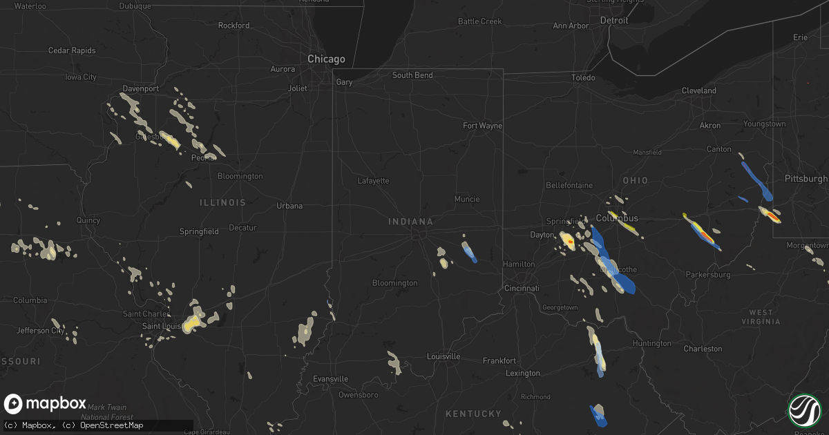
Hail Map in Indiana on July 29, 2021
Get this storm
July 29 map
$229
one time, instant access
Download today. No call, no setup
Keep the $229
Bought the map and want the full workflow? Apply the entire $229 to a subscription within 7 days. None of it is wasted.
Every map, not just this one
This buys you this map. Subscription and you get every map we run, in the markets you choose from a few cities to whole states to nationwide. Plus real-time alerts the moment a storm fires.
Contact data
Name, contact info, occupancy, even credit band for addresses in the footprint. You go from where it hit to who to call.
Become the source they trust
Unlimited branding weather history reports on demand. You already have the documented answer ready for the property owner, and you are the one who showed up with it.
Property data and RoofTrace estimates
Pull up any address you have got, its value and the exact code rules for that jurisdiction, straight from One Click Code. Then RoofTrace estimates the squares, pitch, and roof value, priced the way you price.
Storm reports in Indiana
Indiana
| Date | Description |
|---|---|
| 07/29/20216:58 PM CDT | Nws storm survey confirmed an ef-1 tornado with max wind speed of 90 mph and a path length of 2.50 miles. Max width was 50 yards. |
| 07/29/20215:14 AM CDT | At 1014 PM EDT, a severe thunderstorm was located 10 miles northeast of Columbus, moving south at 20 mph. HAZARD...60 mph wind gusts. SOURCE...Radar indicated. IMPACT...Expect damage to roofs, siding, and trees. This severe thunderstorm will be near... Newbern around 1025 PM EDT. Letts around 1030 PM EDT.Other locations in the path of this severe thunderstorm includeElizabethtown, Westport and Grammer.Rotation has been spotted aloft at times with this storm. |
| 07/29/20214:30 AM CDT | At 929 PM EDT, a severe thunderstorm was located 11 miles south of Shelbyville, moving southeast at 15 mph. HAZARD...60 mph wind gusts. SOURCE...Radar indicated. IMPACT...Expect damage to roofs, siding, and trees. This severe thunderstorm will be near... Hope around 935 PM EDT. Milford around 945 PM EDT.Other locations in the path of this severe thunderstorm includeHartsville, Burney, Newbern and Letts.Rotation has been spotted aloft at times with this storm. |
| 07/29/20213:45 AM CDT | At 843 PM EDT, a severe thunderstorm was located 10 miles west of Greensburg, or 10 miles southeast of Shelbyville, moving southeast at 20 mph. HAZARD...60 mph wind gusts. SOURCE...Radar indicated. IMPACT...Expect damage to roofs, siding, and trees. This severe thunderstorm will be near... Adams and Milford around 855 PM EDT. Burney around 900 PM EDT.Other locations in the path of this severe thunderstorm includeGreensburg, Letts, Westport and Millhousen.Some rotation has been noted aloft with this storm.This includes Interstate 74 between mile markers 120 and 135. |
| 07/29/20213:11 AM CDT | At 811 PM EDT, a severe thunderstorm was located 8 miles southeast of Shelbyville, moving southeast at 15 mph. HAZARD...60 mph wind gusts. SOURCE...Radar indicated. IMPACT...Expect damage to roofs, siding, and trees. This severe thunderstorm will be near... St. Paul around 820 PM EDT.Other locations in the path of this severe thunderstorm includeMilford, Adams, Greensburg and Sandusky.This includes Interstate 74 between mile markers 119 and 135. |
| 07/29/20212:28 AM CDT | At 728 PM CDT, a severe thunderstorm was located near Flat Rock, or 11 miles southeast of Robinson, moving south at 20 mph. HAZARD...60 mph wind gusts and penny size hail. SOURCE...Radar indicated. IMPACT...Expect damage to roofs, siding, and trees. This severe thunderstorm will be near... Russellville around 745 PM CDT. |
| 07/29/20211:20 AM CDT | At 620 PM EDT, a severe thunderstorm was located near Glenwood, moving southeast at 30 mph. HAZARD...60 mph wind gusts and quarter size hail. SOURCE...Radar indicated. IMPACT...Minor hail damage to vehicles is possible. Expect wind damage to trees and power lines. Locations impacted include... Batesville, Brookville, Oldenburg, Glenwood, Lake Santee, Metamora, Laurel, Cedar Grove, Andersonville, Huntersville, Hamburg, Ballstown, Penntown, Interstate 74 at State Route 101, Peppertown, Saint Peter and Buena Vista.This includes I-74 in Indiana between mile markers 145 and 157. |
| 07/29/20211:13 AM CDT | At 613 PM EDT, a severe thunderstorm was located near Rushville, or 14 miles west of Connersville, moving southeast at 15 mph. HAZARD...Quarter size hail. SOURCE...Radar indicated. IMPACT...Damage to vehicles is expected. This severe thunderstorm will be near... Glenwood around 620 PM EDT. New Salem around 625 PM EDT. |
| 07/28/202111:59 PM CDT | At 458 AM EDT, a severe thunderstorm was located near Bremen, moving east at 45 mph. HAZARD...60 mph wind gusts. SOURCE...Radar indicated. IMPACT...Expect damage to roofs, siding, and trees. Locations impacted include... Goshen, Nappanee, Bremen, Ligonier, Syracuse, Wakarusa, Milford, North Webster, Millersburg, New Paris, Benton, Locke, Cromwell, Foraker, Lake Wawasee, Gravelton, Waterford Mills, Wilmot, James Lake and Hastings. |
| 07/28/202111:09 PM CDT | At 409 AM EDT, a severe thunderstorm was located near St. Joseph, moving east at 45 mph. HAZARD...60 mph wind gusts. SOURCE...Radar indicated. IMPACT...Expect damage to roofs, siding, and trees. Locations impacted include... Niles, Benton Harbor, St. Joseph, Dowagiac, Buchanan, Fair Plain, Benton Heights, Bridgman, New Buffalo, Berrien Springs, Watervliet, Three Oaks, Coloma, Stevensville, Shorewood-Tower Hill, Paw Paw Lake, Shorewood-Tower Hills-Harbert, Lake Michigan Beach, Bertrand and Pokagon.This includes the following highways... Interstate 196 between mile markers 0 and 7. Interstate 94 in Michigan between mile markers 3 and 42. |
| 07/28/202110:45 PM CDT | At 344 AM CDT, severe thunderstorms were located along a line extending from Ogden Dunes to Crete to Channahon, moving southeast at 55 mph. HAZARD...70 mph wind gusts. SOURCE...Emergency management. Multiple reports of wind damage across the Chicago metro. IMPACT...Expect considerable tree damage. Damage is likely to mobile homes, roofs, and outbuildings. Locations impacted include... Gary, Portage, Merrillville, Valparaiso, Hobart, Kankakee, Crown Point, Bourbonnais, Bradley, Chesterton, Cedar Lake, Lowell, Manteno, DeMotte, Hebron, Momence, Herscher, Wheatfield, Lake Village and Lake Station. |
| 07/28/20219:58 PM CDT | At 257 AM CDT, severe thunderstorms were located along a line extending from near Hinckley to Winfield to Evanston, moving south at 45 mph. HAZARD...70 mph wind gusts. SOURCE...Emergency management. Multiple reports of wind damage across the northern Chicago metro. IMPACT...Expect considerable tree damage. Damage is likely to mobile homes, roofs, and outbuildings. Locations impacted include... Aurora, Joliet, Naperville, Hammond, Gary, Bolingbrook, Orland Park, Tinley Park, Romeoville, Plainfield, Calumet City, Portage, Merrillville, Woodridge, Oswego, Chicago Heights, East Chicago, Schererville, Hobart and Lansing. |
| 07/28/20218:04 PM CDT | 2-3 inch diameter tree reported down on us 41 at camp arthur rd. |
| 07/28/20217:14 PM CDT | Nws storm survey confirmed an ef1 tornado with max wind speed of 90 mph and a path length of 0.71 miles. The max width was 50 yards. |
| 07/28/20217:07 PM CDT | Trees down. Time estimated from radar. |
| 07/28/20217:00 PM CDT | Roofing material removed from a building at the intersection of pike and howard. |
All States Impacted by Hail Map on July 29, 2021
Cities Impacted by Hail Map on July 29, 2021
- South Charleston, OH
- South Vienna, OH
- London, OH
- Meeker, CO
- Fieldon, IL
- Lebanon, IL
- Trenton, IL
- Highland, IL
- O'Fallon, IL
- Troy, IL
- Saint Jacob, IL
- Douglas, WY
- Cedarville, OH
- Xenia, OH
- Jamestown, OH
- Fenton, MO
- Imperial, MO
- Burtonsville, MD
- Laurel, MD
- South Solon, OH
- Jeffersonville, OH
- Payson, AZ
- Eureka, IL
- Wooton, KY
- Hazard, KY
- Casper, WY
- Evansville, WY
- West Finley, PA
- Wind Ridge, PA
- Cameron, WV
- Dallas, WV
- Wheeling, WV
- Clarkdale, AZ
- Prescott Valley, AZ
- Pinon, AZ
- Millstadt, IL
- Columbia, IL
- Ganado, AZ
- Winslow, AZ
- Teasdale, UT
- Hanksville, UT
- Somerset, CO
- Vanceburg, KY
- Emerson, KY
- Morehead, KY
- Olive Hill, KY
- Fredericksburg, VA
- Peebles, OH
- Hillsboro, OH
- Mancos, CO
- King William, VA
- West Point, VA
- Kaycee, WY
- Gillette, WY
- Lower Salem, OH
- Centennial, WY
- Walkerton, VA
- Kewanee, IL
- West Point, IA
- Washington, IL
- Sabina, OH
- Yellow Springs, OH
- Egnar, CO
- Mount Union, IA
- New London, IA
- Jackson, KY
- Clayhole, KY
- Vancleve, KY
- Lost Creek, KY
- Rousseau, KY
- Newcastle, WY
- Columbus, OH
- Flat Rock, IN
- Benton, IL
- Thompsonville, IL
- Dewey, AZ
- Minden, LA
- Hermann, MO
- Milford, VA
- Bowling Green, VA
- Port Royal, VA
- Woodford, VA
- Yates City, IL
- Williamsfield, IL
- Elmwood, IL
- Knoxville, IL
- Galesburg, IL
- Oneida, IL
- Gilson, IL
- Dahinda, IL
- Coalmont, CO
- Willcox, AZ
- Burlington, IA
- Mediapolis, IA
- Oquawka, IL
- Biggsville, IL
- Gladstone, IL
- Gypsum, CO
- Parachute, CO
- Canal Winchester, OH
- Groveport, OH
- Chinle, AZ
- Bladensburg, MD
- Brentwood, MD
- Riverdale, MD
- Hyattsville, MD
- District Heights, MD
- Capitol Heights, MD
- Washington, DC
- Mount Pleasant, IA
- Saint Stephens Church, VA
- Newtown, VA
- Mayer, AZ
- Humboldt, AZ
- Prescott, AZ
- Hilliard, OH
- Linn, MO
- Albion, IL
- Ellery, IL
- Mount Erie, IL
- West Salem, IL
- Parkersburg, IL
- Tappahannock, VA
- Cortez, CO
- Westerville, OH
- Lewis Center, OH
- Galena, OH
- Cairo, MO
- Rancocas, NJ
- Mount Holly, NJ
- Beverly, NJ
- Willingboro, NJ
- Caldwell, OH
- Glenwood, IN
- Rushville, IN
- Laurel, IN
- Maquon, IL
- Victoria, IL
- Claysville, PA
- West Alexander, PA
- Kaibeto, AZ
- Rowlesburg, WV
- Vincentown, NJ
- Pemberton, NJ
- East Saint Louis, IL
- Calhoun, IL
- Morgantown, WV
- Granite City, IL
- Muscatine, IA
- New Boston, IL
- Dolores, CO
- Glenrock, WY
- Dublin, OH
- Riverside, NJ
- Clifton Hill, MO
- Huntsville, MO
- Excello, MO
- Flagstaff, AZ
- Concho, AZ
- Sedona, AZ
- Aviston, IL
- Mascoutah, IL
- North Henderson, IL
- Batchtown, IL
- Hardin, IL
- Hamburg, IL
- Jerseyville, IL
- Jamesport, MO
- Dunlap, IL
- Chillicothe, IL
- Peoria, IL
- New Holland, OH
- Washington Court House, OH
- Beaver, UT
- Greenville, UT
- Columbia, MD
- Sykesville, MD
- Hanover, MD
- West Friendship, MD
- Ellicott City, MD
- Marriottsville, MD
- Elkridge, MD
- King City, MO
- McFall, MO
- Darlington, MO
- Springfield, OH
- Huntingdon Valley, PA
- Philadelphia, PA
- Feasterville Trevose, PA
- House Springs, MO
- Browns Mills, NJ
- Gueydan, LA
- Cahone, CO
- Goldvein, VA
- Midland, VA
- Grosse Tete, LA
- Toano, VA
- Williamsburg, VA
- Lanexa, VA
- Pleasant Hill, IL
- Corbin, KY
- Safford, AZ
- Chillicothe, OH
- Paris, MO
- Mount Laurel, NJ
- Abington, PA
- Bryn Athyn, PA
- Hainesport, NJ
- Croydon, PA
- Willow Grove, PA
- Jenkintown, PA
- Bensalem, PA
- Burlington, NJ
- Lumberton, NJ
- Blanding, UT
- Manito, IL
- Topeka, IL
- Forest City, IL
- Fairland, IN
- Shelbyville, IN
- Walden, CO
- Stafford, VA
- Aylett, VA
- Roanoke, IL
- Metamora, IL
- Lowpoint, IL
- Pattonsburg, MO
- Vincennes, IN
- Lawrenceville, IL
- Waverly, OH
- Keno, OR
- Chiloquin, OR
- Fort Klamath, OR
- Shelbina, MO
- Stoutsville, MO
- Jacksonville, MO
- Kennard, TX
- Port Saint Joe, FL
- Pennsboro, WV
- Alma, WV
- Kirksville, MO
- Brashear, MO
- Lithopolis, OH
- Lancaster, OH
- Carroll, OH
- Sarahsville, OH
- Summerfield, OH
- Kane, IL
- Annada, MO
- Kampsville, IL
- Nebo, IL
- Eldred, IL
- Elsberry, MO
- Mokane, MO
- Tebbetts, MO
- Annawan, IL
- Powell, OH
- Godfrey, IL
- Bethalto, IL
- Alton, IL
- Vandalia, IL
- Shobonier, IL
- Mulberry Grove, IL
- Letts, IA
- Nichols, IA
- West Union, WV
- Williamsburg, KY
- Frankfort, OH
- Sutherland, NE
- Yellow Jacket, CO
- Bonnots Mill, MO
- Fulton, MO
- New Bloomfield, MO
- Chamois, MO
- Triadelphia, WV
- Graysville, PA
- Piasa, IL
- Brighton, IL
- Eureka, UT
- Laramie, WY
- Speer, IL
- Wyoming, IL
- Atkinson, IL
- Cambridge, IL
- Hambleton, WV
- Parsons, WV
- Alhambra, IL
- Summerfield, IL
- Breese, IL
- Marine, IL
- Scott Air Force Base, IL
- Pocahontas, IL
- Collinsville, IL
- South Salem, OH
- Swan, IA
- Chambers, AZ
- Derby, IN
- Williams, AZ
- Chandlersville, OH
- Cumberland, OH
- Dexter City, OH
- Toulon, IL
- Galva, IL
- La Fayette, IL
- Wapello, IA
- Oakville, IA
- Montrose, CO
- Hurlock, MD
- Trappe, MD
- Smilax, KY
- Pittsfield, IL
- Milton, FL
- Hurricane, UT
- New Douglas, IL
- Sandy Hook, KY
- West Liberty, KY
- Barhamsville, VA
- Bealeton, VA
- Catlett, VA
- Bruington, VA
- Danville, IA
- Aledo, IL
- Milan, MO
- Somerset, KY
- Millsboro, DE
- Shelbyville, MO
- Bethel, MO
- Emden, MO
- Jameson, MO
- Gallatin, MO
- Harbeson, DE
- Georgetown, DE
- Busy, KY
- Hyden, KY
- Green River, UT
- Minerva, OH
- Mechanicstown, OH
- East Rochester, OH
- Kensington, OH
- Monroe City, MO
- Mount Sterling, MO
- Bland, MO
- Green Castle, MO
- Green City, MO
- Clarksville, MO
- Kykotsmovi Village, AZ
- Golconda, IL
- Waldron, IN
- Greenfield, OH
- Bainbridge, OH
- Bone Gap, IL
- Sumner, IL
- Mount Carmel, IL
- Claremont, IL
- Olney, IL
- Browns, IL
- Ramsey, IL
- Collbran, CO
- Fillmore, IL
- Pleasantville, IA
- Saint Paul, IN
- Hope, IN
- Linneus, MO
- Trivoli, IL
- Russell Springs, KY
- Crawfordsville, IA
- Winfield, IA
- Morning Sun, IA
- Argyle, IA
- Montrose, IA
- Bridgeport, IL
- Milton, DE
- New Baden, IL
- Kings Mountain, KY
- Waynesburg, KY
- Crab Orchard, KY
- Dow, IL
- Perry, MO
- Center, MO
- Novinger, MO
- Barnhart, MO
- Kingsbury, TX
- Durango, CO
- Donnellson, IA
- Lewes, DE
- Sheffield, IL
- Buda, IL
- Neponset, IL
- Mineral, IL
- Eubank, KY
- Bradford, IL
- Joy, IL
- Newburg, WV
- Kingwood, WV
- Tunnelton, WV
- Reedsville, WV
- Belleville, IL
- Manchester, OH
- East Carondelet, IL
- Saint Louis, MO
- Leopold, IN
- Eckerty, IN
- Saint Croix, IN
- Bristow, IN
- Cannelton, IN
- Branchville, IN
- English, IN
- Payneville, KY
- Union Star, KY
- Sulphur, IN
- Leavenworth, IN
- Holbrook, PA
- Martins Ferry, OH
- Bridgeport, OH
- Saint Martinville, LA
- Columbus, IN
- Gibbs, MO
- Novelty, MO
- Hurdland, MO
- Sulphur, LA
- Hustonville, KY
- Middleburg, KY
- Foley, MO
- Winfield, MO
- Princeville, IL
- Pagosa Springs, CO
- Moberly, MO
- Independence, WV
- Mount Sterling, OH
- Galt, MO
- Harris, MO
- Titusville, NJ
- Pennington, NJ
- Beaver, OH
- Clarksburg, OH
- Bloomingburg, OH
- Piketon, OH
- Zuni, NM
- Gerlaw, IL
- Monmouth, IL
- Cameron, IL
- Flat Rock, IL
- Morrison, MO
- Lynchburg, OH
- Kaplan, LA
- Madison, MO
- Holliday, MO
- Lentner, MO
- Clarence, MO
- Silver Spring, MD
- Kensington, MD
- Upper Marlboro, MD
- College Park, MD
- Greenbelt, MD
- Takoma Park, MD
- Mount Rainier, MD
- High Ridge, MO
- Eureka, MO
- Tuba City, AZ
- Spickard, MO
- Trenton, MO
- Reynolds, IL
- Viola, IL
- Taylor Ridge, IL
- Illinois City, IL
- Milan, IL
- Alexis, IL
- Matherville, IL
- Geneseo, IL
- Prophetstown, IL
- Otway, OH
- Stout, OH
- Blue Creek, OH
- Lewis, CO
- Gilman City, MO
- Macon, MO
- Eddyville, NE
- Seguin, TX
- Barnhill, IL
- Fairfield, IL
- Lambertville, NJ
- Trenton, NJ
- New Hope, PA
- Lawrence Township, NJ
- Robbinsville, NJ
- Middletown, IA
- Knightstown, IN
- Mays, IN
- Carrollton, IL
- Wilmington, OH
- Zanesville, OH
- Mcconnelsville, OH
- Macksburg, OH
- East Peoria, IL
- Kremmling, CO
- Clifton, AZ
- Brookfield, MO
- Shipman, IL
- Salem, KY
- Hampton, KY
- Smithland, KY
- Peoria Heights, IL
- Edwards, IL
- Mossville, IL
- Edelstein, IL
- East Alton, IL
- McNeal, AZ
- Wilberforce, OH
- Seaman, OH
- Waynesville, OH
- Carlyle, IL
- Greenville, IL
- Keyesport, IL
- Stevensville, VA
- Many Farms, AZ
- Teec Nos Pos, AZ
- Oldenburg, IN
- Milroy, IN
- Greensburg, IN
- Hastings, PA
- Flinton, PA
- Blandburg, PA
- Patton, PA
- Fallentimber, PA
- Cherry Tree, PA
- Tyrone, PA
- Acme, PA
- Mount Pleasant, PA
- Somerset, PA
- Champion, PA
- Jones Mills, PA
- Melcroft, PA
- Donegal, PA
- Carversville, PA
- Doylestown, PA
- Perkasie, PA
- Washington Crossing, PA
- Pipersville, PA
- Ottsville, PA
- Lumberville, PA
- Newtown, PA
- Quakertown, PA
- Waretown, NJ
- Barnegat, NJ
- Manchester Township, NJ
- Jackson, NJ
- Lakehurst, NJ
- Fort Washington, PA
- Oreland, PA
- Dresher, PA
- Moorestown, NJ
- Ambler, PA
- Medford, NJ
- Horsham, PA
- Glenside, PA
- Flourtown, PA
- Chatsworth, NJ
- Riverton, NJ
- Cheltenham, PA
- Slatington, PA
- Hightstown, NJ
- Cochranton, PA
- Guys Mills, PA
- Elkfork, KY
- Rowdy, KY
- Chavies, KY
- Sumerduck, VA
- Spotsylvania, VA
- Severn, MD
- Glen Burnie, MD
- Gambrills, MD
- Harmans, MD
- Jessup, MD
- Baltimore, MD
- Crownsville, MD
- Annapolis, MD
- Linthicum Heights, MD
- Severna Park, MD
- Millersville, MD
- New Kent, VA
- Palestine, IL
- Richmond Dale, OH
- Williamsport, OH
- Jackson, OH
- Ray, OH
- West Liberty, WV
- Wellsburg, WV
- Bergholz, OH
- Richmond, OH
- Amsterdam, OH
- Steubenville, OH
- Salineville, OH
- Bloomingdale, OH
- Valley Grove, WV
- Brilliant, OH
- Beech Bottom, WV
- Rayland, OH
- Mingo Junction, OH
- Bethany, WV
- Carrollton, OH
- Cadiz, OH
- Saint Clairsville, OH
- Blue Rock, OH


