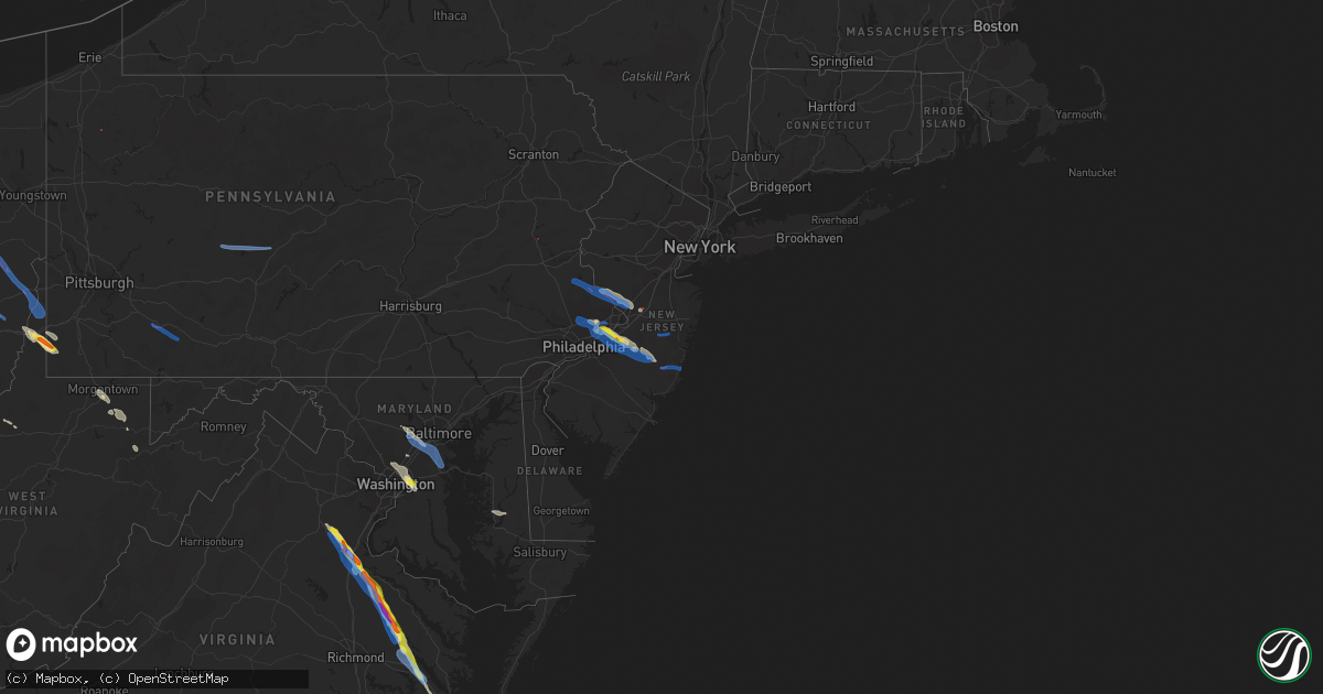
Hail Map in New Jersey on July 29, 2021
Get this storm
July 29 map
$229
one time, instant access
Download today. No call, no setup
Keep the $229
Bought the map and want the full workflow? Apply the entire $229 to a subscription within 7 days. None of it is wasted.
Every map, not just this one
This buys you this map. Subscription and you get every map we run, in the markets you choose from a few cities to whole states to nationwide. Plus real-time alerts the moment a storm fires.
Contact data
Name, contact info, occupancy, even credit band for addresses in the footprint. You go from where it hit to who to call.
Become the source they trust
Unlimited branding weather history reports on demand. You already have the documented answer ready for the property owner, and you are the one who showed up with it.
Property data and RoofTrace estimates
Pull up any address you have got, its value and the exact code rules for that jurisdiction, straight from One Click Code. Then RoofTrace estimates the squares, pitch, and roof value, priced the way you price.
Storm reports in New Jersey
New Jersey
| Date | Description |
|---|---|
| 07/29/20216:35 PM CDT | Large tree uprooted. |
| 07/29/20216:31 PM CDT | Picture of hail near mount holly... Nj. Time estimated from radar. |
| 07/29/20216:30 PM CDT | Metal bleachers displaced... Fence and sign blown down... Some shingles blown off. Time estimated from radar. |
| 07/29/20216:29 PM CDT | A local report indicates 1.25 inch wind near MOUNT HOLLY WFO |
| 07/29/20216:27 PM CDT | Measured 1.5 inch hail. |
| 07/29/20216:26 PM CDT | A local report indicates 1.00 inch wind near MOUNT HOLLY WFO |
| 07/29/20216:19 PM CDT | Picture shared on social media of 1.5 inch hail in willingboro. Time estimated from radar. |
| 07/29/20216:19 PM CDT | Tree blown down... And large branches blown down from other trees. Time estimated from radar. |
| 07/29/20216:19 PM CDT | A local report indicates 1.00 inch wind near EDGEWATER PARK |
| 07/29/20216:10 PM CDT | Trees and wires down along neck road. |
| 07/29/20216:05 PM CDT | Numerous trees down on voelbel road and perrineville road. Possible tornado. Times estimated from radar. |
| 07/29/20215:56 PM CDT | The windsor-robbinsville township tornado began on route 130 just south of the town of windsor near the assunpink creek. A few hardwood trees were uprooted along the hi |
| 07/29/20215:48 PM CDT | Lots of tree branches down and power is out in robbinsville north of 130. Time estimated from radar. |
| 07/29/20215:25 PM CDT | Wires down along west church road. |
| 07/29/20215:19 PM CDT | Multiple trees snapped and uprooted near pennington... Nj. Possible tornado. Time estimated from radar. |
| 07/29/20215:11 PM CDT | Trees and wires down on pleasant valley road in hopewell. |
| 07/29/20215:10 PM CDT | Multiple trees down in titusville... Nj. Possible tornado. Time estimated from radar. |
| 07/29/20215:10 PM CDT | Trees down on nj route 29 with the highway closed. |
| 07/29/20215:02 PM CDT | Few small trees blown down on timothy lane in bedminster. Time estimated from radar. |
| 07/29/20214:57 PM CDT | Numerous reports of trees and lines down in new hope. Possible tornado. Time estimated from radar. |
| 07/29/20214:54 PM CDT | Tree down on house on park ave. |
| 07/29/20214:54 PM CDT | Brief ef0 tornado confirmed by nws storm survey. Tornado likely touched down inside the montclair golf club and traveled northeast. Three full trees and 10-20 large lim |
| 07/29/20214:54 PM CDT | Tree down on power lines and road. |
| 07/29/20214:54 PM CDT | Large tree down on house on sylvan rd. |
| 07/29/20213:03 AM CDT | At 803 PM EDT, severe thunderstorms were located along a line extending from near Holmdel to near Penn State Forest, moving east at 30 mph. HAZARD...60 mph wind gusts and quarter size hail. SOURCE...Radar indicated. IMPACT...Minor damage to vehicles is possible. Wind damage to roofs, siding, trees, and power lines is possible. Locations impacted include... Toms River, Long Branch, Asbury Park, Lakewood, Jackson, Howell, Marlboro, Barnegat, Tinton Falls, Beachwood, Tabernacle, Manasquan, Point Pleasant Beach, Presidential Lakes Estates, Seaside Heights, Lakehurst, Pemberton, Farmingdale, Surf City and Wrightstown.This includes the following highways... Interstate 195 in New Jersey between mile markers 13 and 34. Garden State Parkway between mile markers 60 and 108. |
| 07/28/202111:30 PM CDT | At 429 PM EDT, a severe thunderstorm was located over Coffeetown, or 7 miles northwest of Allentown, moving east at 25 mph. HAZARD...60 mph wind gusts. SOURCE...Radar indicated. IMPACT...Damage to roofs, siding, trees, and power lines is possible. Locations impacted include... Allentown, Easton, Bethlehem, Forks, Emmaus, Northampton, Wilson, Hellertown, Nazareth, Palmerton, Bangor, Slatington, Pen Argyl, Wind Gap, Bath, Harmony, Alpha, Walnutport, Topton and Ferndale.This includes the following highways... Northeast Extension between mile markers 51 and 73. Interstate 78 in Pennsylvania between mile markers 46 and 76. Interstate 78 in New Jersey between mile markers 0 and 4. |
| 07/28/20218:12 PM CDT | Widespread wind damage in high bar harbor. A roof was torn off a building... Boats were overturned... Utility poles were toppled and there was much debris on local road |
| 07/28/20218:00 PM CDT | Downed utility pole and wires blocking nj route 72 eastbound near warren grove road in barnegat township. |
| 07/28/20218:00 PM CDT | Utility pole and wires down blocking nj route 72 near whiting road in barnegat township. |
| 07/28/20217:43 PM CDT | A damaging wind event occurred in the silverton section of toms river... New jersey. The area was surveyed by a national weather service storm survey team. Multiple are |
| 07/28/20217:42 PM CDT | A tornado touched down on the evening of july 29 in a heavily forested area in the eastern portion of woodland twp in southern new jersey. The start location is estimat |
| 07/28/20217:30 PM CDT | Several trees down in the silverton area of toms river. Time estimated from radar. |
| 07/28/20217:04 PM CDT | The tornado touched down east of hawkin road near the intersection of bordens mill branch and success branch in jackson township. The entire life cycle of this tornado |
All States Impacted by Hail Map on July 29, 2021
Cities Impacted by Hail Map on July 29, 2021
- South Charleston, OH
- South Vienna, OH
- London, OH
- Meeker, CO
- Fieldon, IL
- Lebanon, IL
- Trenton, IL
- Highland, IL
- O'Fallon, IL
- Troy, IL
- Saint Jacob, IL
- Douglas, WY
- Cedarville, OH
- Xenia, OH
- Jamestown, OH
- Fenton, MO
- Imperial, MO
- Burtonsville, MD
- Laurel, MD
- South Solon, OH
- Jeffersonville, OH
- Payson, AZ
- Eureka, IL
- Wooton, KY
- Hazard, KY
- Casper, WY
- Evansville, WY
- West Finley, PA
- Wind Ridge, PA
- Cameron, WV
- Dallas, WV
- Wheeling, WV
- Clarkdale, AZ
- Prescott Valley, AZ
- Pinon, AZ
- Millstadt, IL
- Columbia, IL
- Ganado, AZ
- Winslow, AZ
- Teasdale, UT
- Hanksville, UT
- Somerset, CO
- Vanceburg, KY
- Emerson, KY
- Morehead, KY
- Olive Hill, KY
- Fredericksburg, VA
- Peebles, OH
- Hillsboro, OH
- Mancos, CO
- King William, VA
- West Point, VA
- Kaycee, WY
- Gillette, WY
- Lower Salem, OH
- Centennial, WY
- Walkerton, VA
- Kewanee, IL
- West Point, IA
- Washington, IL
- Sabina, OH
- Yellow Springs, OH
- Egnar, CO
- Mount Union, IA
- New London, IA
- Jackson, KY
- Clayhole, KY
- Vancleve, KY
- Lost Creek, KY
- Rousseau, KY
- Newcastle, WY
- Columbus, OH
- Flat Rock, IN
- Benton, IL
- Thompsonville, IL
- Dewey, AZ
- Minden, LA
- Hermann, MO
- Milford, VA
- Bowling Green, VA
- Port Royal, VA
- Woodford, VA
- Yates City, IL
- Williamsfield, IL
- Elmwood, IL
- Knoxville, IL
- Galesburg, IL
- Oneida, IL
- Gilson, IL
- Dahinda, IL
- Coalmont, CO
- Willcox, AZ
- Burlington, IA
- Mediapolis, IA
- Oquawka, IL
- Biggsville, IL
- Gladstone, IL
- Gypsum, CO
- Parachute, CO
- Canal Winchester, OH
- Groveport, OH
- Chinle, AZ
- Bladensburg, MD
- Brentwood, MD
- Riverdale, MD
- Hyattsville, MD
- District Heights, MD
- Capitol Heights, MD
- Washington, DC
- Mount Pleasant, IA
- Saint Stephens Church, VA
- Newtown, VA
- Mayer, AZ
- Humboldt, AZ
- Prescott, AZ
- Hilliard, OH
- Linn, MO
- Albion, IL
- Ellery, IL
- Mount Erie, IL
- West Salem, IL
- Parkersburg, IL
- Tappahannock, VA
- Cortez, CO
- Westerville, OH
- Lewis Center, OH
- Galena, OH
- Cairo, MO
- Rancocas, NJ
- Mount Holly, NJ
- Beverly, NJ
- Willingboro, NJ
- Caldwell, OH
- Glenwood, IN
- Rushville, IN
- Laurel, IN
- Maquon, IL
- Victoria, IL
- Claysville, PA
- West Alexander, PA
- Kaibeto, AZ
- Rowlesburg, WV
- Vincentown, NJ
- Pemberton, NJ
- East Saint Louis, IL
- Calhoun, IL
- Morgantown, WV
- Granite City, IL
- Muscatine, IA
- New Boston, IL
- Dolores, CO
- Glenrock, WY
- Dublin, OH
- Riverside, NJ
- Clifton Hill, MO
- Huntsville, MO
- Excello, MO
- Flagstaff, AZ
- Concho, AZ
- Sedona, AZ
- Aviston, IL
- Mascoutah, IL
- North Henderson, IL
- Batchtown, IL
- Hardin, IL
- Hamburg, IL
- Jerseyville, IL
- Jamesport, MO
- Dunlap, IL
- Chillicothe, IL
- Peoria, IL
- New Holland, OH
- Washington Court House, OH
- Beaver, UT
- Greenville, UT
- Columbia, MD
- Sykesville, MD
- Hanover, MD
- West Friendship, MD
- Ellicott City, MD
- Marriottsville, MD
- Elkridge, MD
- King City, MO
- McFall, MO
- Darlington, MO
- Springfield, OH
- Huntingdon Valley, PA
- Philadelphia, PA
- Feasterville Trevose, PA
- House Springs, MO
- Browns Mills, NJ
- Gueydan, LA
- Cahone, CO
- Goldvein, VA
- Midland, VA
- Grosse Tete, LA
- Toano, VA
- Williamsburg, VA
- Lanexa, VA
- Pleasant Hill, IL
- Corbin, KY
- Safford, AZ
- Chillicothe, OH
- Paris, MO
- Mount Laurel, NJ
- Abington, PA
- Bryn Athyn, PA
- Hainesport, NJ
- Croydon, PA
- Willow Grove, PA
- Jenkintown, PA
- Bensalem, PA
- Burlington, NJ
- Lumberton, NJ
- Blanding, UT
- Manito, IL
- Topeka, IL
- Forest City, IL
- Fairland, IN
- Shelbyville, IN
- Walden, CO
- Stafford, VA
- Aylett, VA
- Roanoke, IL
- Metamora, IL
- Lowpoint, IL
- Pattonsburg, MO
- Vincennes, IN
- Lawrenceville, IL
- Waverly, OH
- Keno, OR
- Chiloquin, OR
- Fort Klamath, OR
- Shelbina, MO
- Stoutsville, MO
- Jacksonville, MO
- Kennard, TX
- Port Saint Joe, FL
- Pennsboro, WV
- Alma, WV
- Kirksville, MO
- Brashear, MO
- Lithopolis, OH
- Lancaster, OH
- Carroll, OH
- Sarahsville, OH
- Summerfield, OH
- Kane, IL
- Annada, MO
- Kampsville, IL
- Nebo, IL
- Eldred, IL
- Elsberry, MO
- Mokane, MO
- Tebbetts, MO
- Annawan, IL
- Powell, OH
- Godfrey, IL
- Bethalto, IL
- Alton, IL
- Vandalia, IL
- Shobonier, IL
- Mulberry Grove, IL
- Letts, IA
- Nichols, IA
- West Union, WV
- Williamsburg, KY
- Frankfort, OH
- Sutherland, NE
- Yellow Jacket, CO
- Bonnots Mill, MO
- Fulton, MO
- New Bloomfield, MO
- Chamois, MO
- Triadelphia, WV
- Graysville, PA
- Piasa, IL
- Brighton, IL
- Eureka, UT
- Laramie, WY
- Speer, IL
- Wyoming, IL
- Atkinson, IL
- Cambridge, IL
- Hambleton, WV
- Parsons, WV
- Alhambra, IL
- Summerfield, IL
- Breese, IL
- Marine, IL
- Scott Air Force Base, IL
- Pocahontas, IL
- Collinsville, IL
- South Salem, OH
- Swan, IA
- Chambers, AZ
- Derby, IN
- Williams, AZ
- Chandlersville, OH
- Cumberland, OH
- Dexter City, OH
- Toulon, IL
- Galva, IL
- La Fayette, IL
- Wapello, IA
- Oakville, IA
- Montrose, CO
- Hurlock, MD
- Trappe, MD
- Smilax, KY
- Pittsfield, IL
- Milton, FL
- Hurricane, UT
- New Douglas, IL
- Sandy Hook, KY
- West Liberty, KY
- Barhamsville, VA
- Bealeton, VA
- Catlett, VA
- Bruington, VA
- Danville, IA
- Aledo, IL
- Milan, MO
- Somerset, KY
- Millsboro, DE
- Shelbyville, MO
- Bethel, MO
- Emden, MO
- Jameson, MO
- Gallatin, MO
- Harbeson, DE
- Georgetown, DE
- Busy, KY
- Hyden, KY
- Green River, UT
- Minerva, OH
- Mechanicstown, OH
- East Rochester, OH
- Kensington, OH
- Monroe City, MO
- Mount Sterling, MO
- Bland, MO
- Green Castle, MO
- Green City, MO
- Clarksville, MO
- Kykotsmovi Village, AZ
- Golconda, IL
- Waldron, IN
- Greenfield, OH
- Bainbridge, OH
- Bone Gap, IL
- Sumner, IL
- Mount Carmel, IL
- Claremont, IL
- Olney, IL
- Browns, IL
- Ramsey, IL
- Collbran, CO
- Fillmore, IL
- Pleasantville, IA
- Saint Paul, IN
- Hope, IN
- Linneus, MO
- Trivoli, IL
- Russell Springs, KY
- Crawfordsville, IA
- Winfield, IA
- Morning Sun, IA
- Argyle, IA
- Montrose, IA
- Bridgeport, IL
- Milton, DE
- New Baden, IL
- Kings Mountain, KY
- Waynesburg, KY
- Crab Orchard, KY
- Dow, IL
- Perry, MO
- Center, MO
- Novinger, MO
- Barnhart, MO
- Kingsbury, TX
- Durango, CO
- Donnellson, IA
- Lewes, DE
- Sheffield, IL
- Buda, IL
- Neponset, IL
- Mineral, IL
- Eubank, KY
- Bradford, IL
- Joy, IL
- Newburg, WV
- Kingwood, WV
- Tunnelton, WV
- Reedsville, WV
- Belleville, IL
- Manchester, OH
- East Carondelet, IL
- Saint Louis, MO
- Leopold, IN
- Eckerty, IN
- Saint Croix, IN
- Bristow, IN
- Cannelton, IN
- Branchville, IN
- English, IN
- Payneville, KY
- Union Star, KY
- Sulphur, IN
- Leavenworth, IN
- Holbrook, PA
- Martins Ferry, OH
- Bridgeport, OH
- Saint Martinville, LA
- Columbus, IN
- Gibbs, MO
- Novelty, MO
- Hurdland, MO
- Sulphur, LA
- Hustonville, KY
- Middleburg, KY
- Foley, MO
- Winfield, MO
- Princeville, IL
- Pagosa Springs, CO
- Moberly, MO
- Independence, WV
- Mount Sterling, OH
- Galt, MO
- Harris, MO
- Titusville, NJ
- Pennington, NJ
- Beaver, OH
- Clarksburg, OH
- Bloomingburg, OH
- Piketon, OH
- Zuni, NM
- Gerlaw, IL
- Monmouth, IL
- Cameron, IL
- Flat Rock, IL
- Morrison, MO
- Lynchburg, OH
- Kaplan, LA
- Madison, MO
- Holliday, MO
- Lentner, MO
- Clarence, MO
- Silver Spring, MD
- Kensington, MD
- Upper Marlboro, MD
- College Park, MD
- Greenbelt, MD
- Takoma Park, MD
- Mount Rainier, MD
- High Ridge, MO
- Eureka, MO
- Tuba City, AZ
- Spickard, MO
- Trenton, MO
- Reynolds, IL
- Viola, IL
- Taylor Ridge, IL
- Illinois City, IL
- Milan, IL
- Alexis, IL
- Matherville, IL
- Geneseo, IL
- Prophetstown, IL
- Otway, OH
- Stout, OH
- Blue Creek, OH
- Lewis, CO
- Gilman City, MO
- Macon, MO
- Eddyville, NE
- Seguin, TX
- Barnhill, IL
- Fairfield, IL
- Lambertville, NJ
- Trenton, NJ
- New Hope, PA
- Lawrence Township, NJ
- Robbinsville, NJ
- Middletown, IA
- Knightstown, IN
- Mays, IN
- Carrollton, IL
- Wilmington, OH
- Zanesville, OH
- Mcconnelsville, OH
- Macksburg, OH
- East Peoria, IL
- Kremmling, CO
- Clifton, AZ
- Brookfield, MO
- Shipman, IL
- Salem, KY
- Hampton, KY
- Smithland, KY
- Peoria Heights, IL
- Edwards, IL
- Mossville, IL
- Edelstein, IL
- East Alton, IL
- McNeal, AZ
- Wilberforce, OH
- Seaman, OH
- Waynesville, OH
- Carlyle, IL
- Greenville, IL
- Keyesport, IL
- Stevensville, VA
- Many Farms, AZ
- Teec Nos Pos, AZ
- Oldenburg, IN
- Milroy, IN
- Greensburg, IN
- Hastings, PA
- Flinton, PA
- Blandburg, PA
- Patton, PA
- Fallentimber, PA
- Cherry Tree, PA
- Tyrone, PA
- Acme, PA
- Mount Pleasant, PA
- Somerset, PA
- Champion, PA
- Jones Mills, PA
- Melcroft, PA
- Donegal, PA
- Carversville, PA
- Doylestown, PA
- Perkasie, PA
- Washington Crossing, PA
- Pipersville, PA
- Ottsville, PA
- Lumberville, PA
- Newtown, PA
- Quakertown, PA
- Waretown, NJ
- Barnegat, NJ
- Manchester Township, NJ
- Jackson, NJ
- Lakehurst, NJ
- Fort Washington, PA
- Oreland, PA
- Dresher, PA
- Moorestown, NJ
- Ambler, PA
- Medford, NJ
- Horsham, PA
- Glenside, PA
- Flourtown, PA
- Chatsworth, NJ
- Riverton, NJ
- Cheltenham, PA
- Slatington, PA
- Hightstown, NJ
- Cochranton, PA
- Guys Mills, PA
- Elkfork, KY
- Rowdy, KY
- Chavies, KY
- Sumerduck, VA
- Spotsylvania, VA
- Severn, MD
- Glen Burnie, MD
- Gambrills, MD
- Harmans, MD
- Jessup, MD
- Baltimore, MD
- Crownsville, MD
- Annapolis, MD
- Linthicum Heights, MD
- Severna Park, MD
- Millersville, MD
- New Kent, VA
- Palestine, IL
- Richmond Dale, OH
- Williamsport, OH
- Jackson, OH
- Ray, OH
- West Liberty, WV
- Wellsburg, WV
- Bergholz, OH
- Richmond, OH
- Amsterdam, OH
- Steubenville, OH
- Salineville, OH
- Bloomingdale, OH
- Valley Grove, WV
- Brilliant, OH
- Beech Bottom, WV
- Rayland, OH
- Mingo Junction, OH
- Bethany, WV
- Carrollton, OH
- Cadiz, OH
- Saint Clairsville, OH
- Blue Rock, OH


