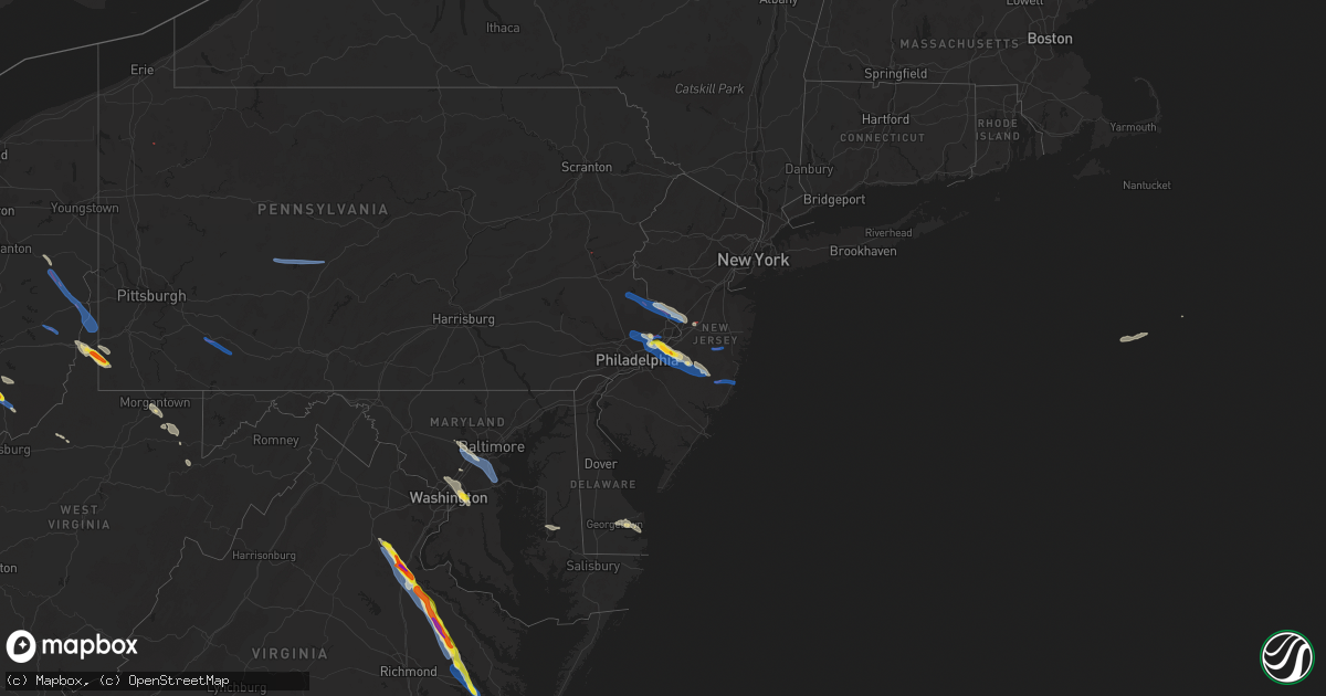
Hail Map on July 29, 2021
Get this storm
July 29 map
$229
one time, instant access
Download today. No call, no setup
Keep the $229
Bought the map and want the full workflow? Apply the entire $229 to a subscription within 7 days. None of it is wasted.
Every map, not just this one
This buys you this map. Subscription and you get every map we run, in the markets you choose from a few cities to whole states to nationwide. Plus real-time alerts the moment a storm fires.
Contact data
Name, contact info, occupancy, even credit band for addresses in the footprint. You go from where it hit to who to call.
Become the source they trust
Unlimited branding weather history reports on demand. You already have the documented answer ready for the property owner, and you are the one who showed up with it.
Property data and RoofTrace estimates
Pull up any address you have got, its value and the exact code rules for that jurisdiction, straight from One Click Code. Then RoofTrace estimates the squares, pitch, and roof value, priced the way you price.
States Impacted by Hail Map on July 29, 2021
Storm reports
District of Columbia
| Date | Description |
|---|---|
| 07/29/202112:30 AM CDT | At 530 PM EDT, a severe thunderstorm was located over Fedex Field, moving southeast at 25 mph. HAZARD...60 mph wind gusts and quarter size hail. SOURCE...Radar indicated. IMPACT...Damaging winds will cause some trees and large branches to fall. This could injure those outdoors, as well as damage homes and vehicles. Roadways may become blocked by downed trees. Localized power outages are possible. Unsecured light objects may become projectiles. Locations impacted include... Bowie, Clinton, Forestville, Largo, Coral Hills, Bladensburg, Shady Side, Chesapeake Beach, Deale, Upper Marlboro, Breezy Point, Fedex Field, RFK Stadium, Andrews Air Force Base, Landover, Camp Springs, East Riverdale, Kettering, New Carrollton and Walker Mill. |
Texas
| Date | Description |
|---|---|
| 07/29/20212:54 AM CDT | At 754 PM CDT, a severe thunderstorm was located 14 miles east of Franklin, or 22 miles northwest of Madisonville, moving northwest at 10 mph. HAZARD...60 mph wind gusts and nickel size hail. SOURCE...Radar indicated. IMPACT...Expect damage to roofs, siding, and trees. Locations impacted include... Marquez. |
Nebraska
| Date | Description |
|---|---|
| 07/29/20212:20 AM CDT | At 720 PM CDT/620 PM MDT/, a severe thunderstorm was located near Sutherland Reservoir State Recreation Area, or 21 miles west of North Platte, moving northwest at 15 mph. HAZARD...60 mph wind gusts and quarter size hail. SOURCE...Radar indicated. IMPACT...Hail damage to vehicles is expected. Expect wind damage to roofs, siding, and trees. Locations impacted include... Sutherland, Hershey, Paxton, Sutherland Reservoir State Recreation Area, Sarben, Big Bald Hill, Coker, O'Fallons and Nevens.This includes Interstate 80 in Nebraska between mile markers 143 and165. |
Utah
| Date | Description |
|---|---|
| 07/29/20213:38 PM CDT | Reported at canyon breeze golf course. Large mature pine tree also blown over. Time estimated by radar. |
| 07/29/20212:41 AM CDT | At 741 PM MDT, a severe thunderstorm was located near Capitol Reef National Park, moving northwest at 20 mph. HAZARD...60 mph wind gusts and half dollar size hail. SOURCE...Radar indicated. IMPACT...Hail damage to vehicles is expected. Expect wind damage to roofs, siding, and trees. Locations impacted include... Capitol Reef National Park, Torrey, Teasdale and Fruita. This includes the following highways... Utah Route 12 between mile markers 107 and 122. Utah Route 24 between mile markers 66 and 84. |
| 07/29/202112:42 AM CDT | At 542 PM MDT, a severe thunderstorm was located 7 miles west of Escalante, moving northwest at 10 mph. HAZARD...60 mph wind gusts and quarter size hail. SOURCE...Radar indicated. IMPACT...Hail damage to vehicles is expected. Expect wind damage to roofs, siding, and trees. Locations impacted include... Escalante.This includes Utah Route 12 between mile markers 46 and 59. |
| 07/28/202111:54 PM CDT | At 453 PM MDT, a severe thunderstorm was located 9 miles southwest of Koosharem, or 17 miles northeast of Junction, moving north at 20 mph. HAZARD...60 mph wind gusts and quarter size hail. SOURCE...Radar indicated. IMPACT...Hail damage to vehicles is expected. Expect wind damage to roofs, siding, and trees. Locations impacted include... Monroe, Koosharem, Burrville and Greenwich. This includes Utah Route 24 near mile marker 30. |
| 07/28/202111:48 PM CDT | At 448 PM MDT, a severe thunderstorm was located 9 miles south of Panguitch Lake, or 26 miles east of Cedar City, moving northwest at 15 mph. HAZARD...60 mph wind gusts and quarter size hail. SOURCE...Radar indicated. IMPACT...Hail damage to vehicles is expected. Expect wind damage to roofs, siding, and trees. Locations impacted include... Panguitch Lake. |
| 07/28/202110:40 PM CDT | Us-6 at sr 123 junction - 5523 ft |
| 07/28/20219:39 PM CDT | At 239 PM MDT, a severe thunderstorm was located near Beaver, moving northeast at 5 mph. HAZARD...Ping pong ball size hail and 60 mph wind gusts. SOURCE...Radar indicated. IMPACT...People and animals outdoors will be injured. Expect hail damage to roofs, siding, windows, and vehicles. Expect wind damage to roofs, siding, and trees. Locations impacted include... Beaver and Manderfield. This includes the following highways... Interstate 15 between mile markers 105 and 121. Utah Route 21 between mile markers 100 and 107. |
| 07/28/20219:00 PM CDT | At 159 PM MDT, a severe thunderstorm was located 14 miles north of New Harmony, or 15 miles west of Cedar City, moving east at 5 mph. HAZARD...Ping pong ball size hail. SOURCE...Radar indicated. IMPACT...People and animals outdoors will be injured. Expect damage to roofs, siding, windows, and vehicles. Locations impacted include... Cedar City.This includes Utah Route 56 between mile markers 38 and 56. |
Colorado
| Date | Description |
|---|---|
| 07/29/20216:30 PM CDT | A local report indicates 1.00 inch wind near 6 WSW WALDEN |
| 07/29/20213:25 AM CDT | At 824 PM MDT, a severe thunderstorm was located 20 miles northwest of Parachute, or 39 miles north of Grand Junction, and is nearly stationary. HAZARD...60 mph wind gusts and quarter size hail. SOURCE...Radar indicated. IMPACT...Hail damage to vehicles is expected. Expect wind damage to roofs, siding, and trees. This severe thunderstorm will remain over mainly rural areas of central Garfield and south central Rio Blanco Counties. |
| 07/29/20212:50 AM CDT | At 750 PM MDT, a severe thunderstorm was located 13 miles northwest of Meeker, or 35 miles southwest of Craig, moving northwest at 15 mph. HAZARD...60 mph wind gusts and quarter size hail. SOURCE...Radar indicated. IMPACT...Hail damage to vehicles is expected. Expect wind damage to roofs, siding, and trees. This severe thunderstorm will remain over mainly rural areas of south central Moffat and north central Rio Blanco Counties. |
| 07/29/202112:21 AM CDT | At 520 PM MDT, a severe thunderstorm was located 5 miles northeast of Coalmont, or 62 miles southwest of Laramie, moving north at 5 mph. HAZARD...60 mph wind gusts and quarter size hail. SOURCE...Radar indicated. IMPACT...Expect damage to roofs, siding, and trees. Hail damage to vehicles is expected. Locations impacted include... Walden, Lake John and Coalmont. |
| 07/28/202110:52 PM CDT | At 352 PM MDT, a severe thunderstorm was located 16 miles northeast of Aneth moving west at 10 mph. HAZARD...60 mph wind gusts and quarter size hail. SOURCE...Radar indicated. IMPACT...Hail damage to vehicles is expected. Expect wind damage to roofs, siding, and trees. This severe thunderstorm will remain over mainly rural areas of west central Montezuma County. |
| 07/28/202110:52 PM CDT | At 352 PM MDT, a severe thunderstorm was located near Lake Owen Campground, or 24 miles west of Laramie, moving southeast at 15 mph. HAZARD...60 mph wind gusts and quarter size hail. SOURCE...Radar indicated. IMPACT...Hail damage to vehicles is expected. Expect wind damage to roofs, siding, and trees. Locations impacted include... Albany, Woods Landing-Jelm, Lake Owen Campground, Lake Hattie Reservoir, Woods Landing, Lake Owen and Hutton Lake. |
| 07/28/202110:28 PM CDT | At 327 PM MDT, a severe thunderstorm was located 14 miles west of Cortez or 38 miles southeast of Blanding moving west at 15 mph. HAZARD...60 mph wind gusts, quarter size hail and heavy rainfall. SOURCE...Radar indicated. IMPACT...Hail damage to vehicles is expected. Expect wind damage to roofs, siding, and trees. This severe thunderstorm will remain over mainly rural areas of west central Montezuma County. |
| 07/28/202110:18 PM CDT | At 317 PM MDT, a severe thunderstorm was located near Norwood, or 38 miles southwest of Montrose, moving north at 15 mph. HAZARD...60 mph wind gusts, quarter size hail and heavy hail. SOURCE...Radar indicated. IMPACT...Hail damage to vehicles is expected. Expect wind damage to roofs, siding, and trees. Locations impacted include... Norwood.This includes the following highways... Colorado 141 between mile markers 50 and 51. Colorado 145 between mile markers 101 and 108. |
| 07/28/202110:07 PM CDT | At 306 PM MDT, a severe thunderstorm was located 9 miles west of Cortez, or 41 miles north of Shiprock, moving west at 10 mph. HAZARD...60 mph wind gusts, quarter size hail, and heavy rainfall. SOURCE...Radar indicated. IMPACT...Hail damage to vehicles is expected. Expect wind damage to roofs, siding, and trees. This severe thunderstorm will remain over mainly rural areas of west central Montezuma County, including the following locations... Arriola. |
Delaware
| Date | Description |
|---|---|
| 07/29/20211:59 PM CDT | One inch hail reported north of long neck... De. |
| 07/29/20211:48 PM CDT | A supercell thunderstorm impacted the eastern portions of sussex county... De in the early afternoon hours of july 29. The national weather service investigated reports |
| 07/28/20219:43 PM CDT | At 243 PM EDT, a severe thunderstorm was located near Milton, or near Georgetown, moving east at 15 mph. HAZARD...60 mph wind gusts and quarter size hail. SOURCE...Radar indicated. IMPACT...Minor damage to vehicles is possible. Wind damage to roofs, siding, trees, and power lines is possible. Locations impacted include... Lewes, Henlopen Acres, Cape Henlopen State Park, Long Neck and Dewey Beach. |
Illinois
| Date | Description |
|---|---|
| 07/29/20215:40 PM CDT | Damaged crops... Trees... And an outbuilding. Delayed report from yesterday. |
| 07/29/20214:56 AM CDT | At 955 PM CDT, severe thunderstorms were located along a line extending from near Carlinville to near Alhambra, moving east at 40 mph. HAZARD...60 mph wind gusts. SOURCE...Radar indicated. IMPACT...Expect damage to roofs, siding, and trees. Severe thunderstorms will be near... Sorento around 1000 PM CDT. Reno around 1005 PM CDT. Litchfield around 1015 PM CDT.Other locations in the path of these severe thunderstorms includeGreenville, Hillsboro, Taylor Springs, Coffeen and Schram City.This includes Interstate 55 in Illinois between exits 33 and 52. This also includes Beaver Dam State Park and Lake Lou Yaeger. |
| 07/29/20214:30 AM CDT | At 929 PM CDT, a severe thunderstorm was located over Parkersburg, or 8 miles southeast of Olney, moving south at 20 mph. HAZARD...60 mph wind gusts and quarter size hail. SOURCE...Radar indicated. IMPACT...Hail damage to vehicles is expected. Expect wind damage to roofs, siding, and trees. This severe thunderstorm will be near... Parkersburg around 935 PM CDT. |
| 07/29/20214:16 AM CDT | At 916 PM CDT, a severe thunderstorm was located near Sumner, or 9 miles southwest of Lawrenceville, moving south at 20 mph. HAZARD...60 mph wind gusts and quarter size hail. SOURCE...Radar indicated. IMPACT...Hail damage to vehicles is expected. Expect wind damage to roofs, siding, and trees. This severe thunderstorm will remain over mainly rural areas of southwestern Lawrence and southeastern Richland Counties, including the following locations... Berryville, Helena and Mount Carmel Airport. |
| 07/28/202110:37 PM CDT | Delayed report. A couple of trees and branches up to 18 inches in diameter snapped as well as many other smaller branches and trees downed along highbanks rd. A flag po |
| 07/28/202110:34 PM CDT | Delayed report. Numerous large tree branches up to 12 inches in diameter snapped throughout mascoutah. A utility pole was also snapped at its base. Time estimated from |
| 07/28/20219:14 PM CDT | At 212 AM CDT, severe thunderstorms were located along a line extending from near Kenosha to near Woodstock to Pecatonica, moving southeast at 55 mph. HAZARD...70 mph wind gusts. SOURCE...Radar indicated. IMPACT...Expect considerable tree damage. Damage is likely to mobile homes, roofs, and outbuildings. Locations impacted include... Chicago, Aurora, Naperville, Elgin, Cicero, Arlington Heights, Evanston, Schaumburg, Bolingbrook, Palatine, Skokie, Des Plaines, Oak Lawn, Berwyn, Mount Prospect, Wheaton, Hoffman Estates, Oak Park, Downers Grove and Glenview. |
| 07/28/20218:17 PM CDT | At 116 AM CDT, severe thunderstorms were located along a line extending from Slinger to near Jefferson to near Brooklyn, moving southeast at 45 mph. HAZARD...70 mph wind gusts. SOURCE...Trained weather spotter estimated 70 mph winds in Johnson Creek . IMPACT...Expect considerable tree damage. Damage is likely to mobile homes, roofs, and outbuildings. Locations impacted include... Milwaukee, Kenosha, Racine, Waukesha, Janesville, West Allis, Wauwatosa, New Berlin, Brookfield, Beloit, Greenfield, Menomonee Falls, Oak Creek, Mount Pleasant, Muskego, South Milwaukee, Pleasant Prairie, Cudahy, Whitewater and Whitefish Bay.People attending The Waukesha Kennel Club Dog Show, The Rock County4H Fair in Janesville, and The Racine County Fair in Union Groveshould seek safe shelter immediately!This includes the following Locations Milwaukee County SportsComplex, Milkman Stadium, Bayshore Shopping Center, Southridge Mall,Boerner Botanical Gardens, General Mitchell International Airport,Timmerman Airport, Froedert & the Medical College, Fiserv Forum,Mayfair Mall, Pewaukee Lake, Ottawa Lake Recreation Area, andPinewoods Campground. |
| 07/28/20217:20 PM CDT | Resident saw tornado touch down. Multiple powerlines reported down. Time estimated from radar. |
Wisconsin
| Date | Description |
|---|---|
| 07/29/20215:12 PM CDT | Nws storm survey has confirmed an ef-1 tornado south of portage. This tornado produced an area of damage to trees... Mobile homes... And outbuilding structures between |
| 07/29/20217:57 AM CDT | At 1256 AM CDT, severe thunderstorms were located along a line extending from near Lomira to near Waterloo, moving east at 35 mph. HAZARD...60 mph wind gusts. SOURCE...Radar indicated. IMPACT...Expect damage to roofs, siding, and trees. Locations impacted include... West Bend, Watertown, Beaver Dam, Hartford, Waupun, Jackson, Mayville, Slinger, Kewaskum, Horicon, Juneau, Germantown, Lomira, Theresa, Newburg, Hustisford, Iron Ridge, Burnett, Richfield and Addison.This includes the following Location Horicon Marsh. |
| 07/29/20217:51 AM CDT | At 1249 AM CDT, severe thunderstorms were located along a line extending from near Cross Plains to 7 miles southeast of Muscoda, moving southeast at 45 mph. HAZARD...60 mph wind gusts. SOURCE...Radar indicated. At 61 MPH was reported at Lone Rock Airport. IMPACT...Expect damage to roofs, siding, and trees. Locations impacted include... Dodgeville, Mineral Point, Mazomanie, Spring Green, Blanchardville, Barneveld, Blue Mounds, Highland, Arena, Ridgeway, Centerville, Avoca, Orion, Linden, Waldwick, Cobb, Clyde, Rewey, Hollandale and Blackhawk Lake Rec Area.This includes the following Locations Hyde's Mill, The House on theRock, and Iowa-Grant School. |
| 07/29/20217:45 AM CDT | At 1245 AM CDT, severe thunderstorms were located along a line extending from near Fall River to near Marshall to near Cross Plains, moving southeast at 50 mph. HAZARD...60 mph wind gusts. SOURCE...Radar indicated. IMPACT...Expect damage to roofs, siding, and trees. Locations impacted include... Madison, Sun Prairie, Fitchburg, Watertown, Middleton, Whitewater, Stoughton, Fort Atkinson, Waunakee, Verona, Oregon, Jefferson, McFarland, Monona, Mount Horeb, Windsor, Lake Mills, Edgerton, Marshall and Waterloo.People attending The CrossFit Games in Madison should seek safeshelter immediately!This includes the following Location Wisconsin State Capitol. |
| 07/29/20217:22 AM CDT | At 1222 AM CDT, severe thunderstorms were located along a line extending from near Pardeeville to near Lake Wisconsin, moving southeast at 40 mph. HAZARD...60 mph wind gusts. SOURCE...Radar indicated. IMPACT...Expect damage to roofs, siding, and trees. Locations impacted include... Sun Prairie, Waunakee, Windsor, Columbus, Lake Wisconsin, Deforest, Lodi, Poynette, Pardeeville, Randolph, Fall River, Rio, Cambria, Dane, Arlington, Wyocena, Otsego, Merrimac, Friesland and Doylestown.This includes the following Locations Gibraltar Rock Natural AreaCounty Park and Alliant Energy Portage Power Plant. |
| 07/28/20218:49 PM CDT | At 147 AM CDT, severe thunderstorms were located along a line extending from near Oak Creek to near Delavan, moving southeast at 50 mph. HAZARD...70 mph wind gusts. SOURCE...Radar indicated. IMPACT...Expect considerable tree damage. Damage is likely to mobile homes, roofs, and outbuildings. Locations impacted include... Waukegan, Arlington Heights, Palatine, Buffalo Grove, Crystal Lake, Wheeling, Northbrook, North Chicago, Gurnee, Mundelein, Algonquin, Highland Park, Lake in the Hills, Round Lake Beach, McHenry, Vernon Hills, Woodstock, Zion, Huntley and Grayslake.This includes...Chain O Lakes State Park, College of Lake County, Great Lakes Naval Training Center, IL Beach State Park, Lake County IL Fairgrounds, Lake Forest College, Mchenry County College, Mchenry County Fairgrounds, and Moraine Hills State Park. |
| 07/28/20218:30 PM CDT | At 129 AM CDT, severe thunderstorms were located along a line extending from near Albany to Platteville, moving southeast at 35 mph. HAZARD...70 mph wind gusts. SOURCE...Radar indicated. IMPACT...Expect considerable tree damage. Damage is likely to mobile homes, roofs, and outbuildings. Severe thunderstorms will be near... Scales Mound and Council Hill around 200 AM CDT. Apple River around 205 AM CDT. Schapville around 210 AM CDT. Elizabeth and Woodbine around 220 AM CDT. Stockton around 225 AM CDT. Massbach around 230 AM CDT.Other locations impacted by these severe thunderstorms includeEleroy, Whitton, North Hanover, Elizabeth Fairgrounds, Damascus, Aiken, Mc Connell, Scioto Mills and Winneshiek. |
| 07/28/20218:23 PM CDT | At 123 AM CDT, severe thunderstorms were located along a line extending from near Monticello to near Whitewater, moving southeast at 40 mph. HAZARD...70 mph wind gusts. SOURCE...Radar indicated. IMPACT...Expect considerable tree damage. Damage is likely to mobile homes, roofs, and outbuildings. Locations impacted include... Rockford, Beloit, Lake in the Hills, Belvidere, Woodstock, Huntley, Loves Park, Machesney Park, Roscoe, Harvard, South Beloit, Rockton, Marengo, Poplar Grove, Rockford Airport, Hampshire, Candlewick Lake, Cherry Valley, Winnebago and Davis Junction.Including the following interstates... I-39 between mile markers 115 and 123. I-90 between mile markers 0 and 41.This includes...Boone County Fairgrounds, Mchenry County Fairgrounds, Rock Cut State Park, Rock Valley College, Rockford Rivets Baseball, Rockford Speedway, and Winnebago County Fairgrounds. |
| 07/28/20218:07 PM CDT | At 106 AM CDT, severe thunderstorms were located along a line extending from Oregon to near New Glarus to 8 miles southeast of Fennimore, moving southeast at 50 mph. HAZARD...60 mph wind gusts. SOURCE...Radar indicated. IMPACT...Expect damage to roofs, siding, and trees. Locations impacted include... Monroe, Brodhead, Darlington, New Glarus, Brooklyn, Shullsburg, Monticello, Albany, Belmont, Benton, Argyle, Blanchardville, Wiota, Dayton, New Diggings, South Wayne, Elk Grove, Fayette, Lamont and Browntown.This includes the following Location York Memorial Church. |
Missouri
| Date | Description |
|---|---|
| 07/29/20212:06 AM CDT | At 705 PM CDT, severe thunderstorms were located along a line extending from 6 miles northeast of Paris to near Perry to near Spencerburg, moving southeast at 10 mph. HAZARD...60 mph wind gusts and quarter size hail. SOURCE...Radar indicated. IMPACT...Hail damage to vehicles is expected. Expect wind damage to roofs, siding, and trees. Severe thunderstorms will be near... Spencerburg around 710 PM CDT.Other locations in the path of these severe thunderstorms includePerry, Vandalia, Curryville and Santa Fe.This also includes Mark Twain Lake Recreational Area. |
| 07/28/202110:09 PM CDT | Approximately 6 inch diameter tree snapped. Twitter report. Time estimated from radar. |
| 07/28/20218:30 PM CDT | Krcg tv relayed public report of tree limb damage at moberly community college campus. Estimated 6 to 8 inch diameter limb fell. |
New Jersey
| Date | Description |
|---|---|
| 07/29/20216:35 PM CDT | Large tree uprooted. |
| 07/29/20216:31 PM CDT | Picture of hail near mount holly... Nj. Time estimated from radar. |
| 07/29/20216:30 PM CDT | Metal bleachers displaced... Fence and sign blown down... Some shingles blown off. Time estimated from radar. |
| 07/29/20216:29 PM CDT | A local report indicates 1.25 inch wind near MOUNT HOLLY WFO |
| 07/29/20216:27 PM CDT | Measured 1.5 inch hail. |
| 07/29/20216:26 PM CDT | A local report indicates 1.00 inch wind near MOUNT HOLLY WFO |
| 07/29/20216:19 PM CDT | Picture shared on social media of 1.5 inch hail in willingboro. Time estimated from radar. |
| 07/29/20216:19 PM CDT | Tree blown down... And large branches blown down from other trees. Time estimated from radar. |
| 07/29/20216:19 PM CDT | A local report indicates 1.00 inch wind near EDGEWATER PARK |
| 07/29/20216:10 PM CDT | Trees and wires down along neck road. |
| 07/29/20216:05 PM CDT | Numerous trees down on voelbel road and perrineville road. Possible tornado. Times estimated from radar. |
| 07/29/20215:56 PM CDT | The windsor-robbinsville township tornado began on route 130 just south of the town of windsor near the assunpink creek. A few hardwood trees were uprooted along the hi |
| 07/29/20215:48 PM CDT | Lots of tree branches down and power is out in robbinsville north of 130. Time estimated from radar. |
| 07/29/20215:25 PM CDT | Wires down along west church road. |
| 07/29/20215:19 PM CDT | Multiple trees snapped and uprooted near pennington... Nj. Possible tornado. Time estimated from radar. |
| 07/29/20215:11 PM CDT | Trees and wires down on pleasant valley road in hopewell. |
| 07/29/20215:10 PM CDT | Multiple trees down in titusville... Nj. Possible tornado. Time estimated from radar. |
| 07/29/20215:10 PM CDT | Trees down on nj route 29 with the highway closed. |
| 07/29/20215:02 PM CDT | Few small trees blown down on timothy lane in bedminster. Time estimated from radar. |
| 07/29/20214:57 PM CDT | Numerous reports of trees and lines down in new hope. Possible tornado. Time estimated from radar. |
| 07/29/20214:54 PM CDT | Large tree down on house on sylvan rd. |
| 07/29/20214:54 PM CDT | Tree down on house on park ave. |
| 07/29/20214:54 PM CDT | Tree down on power lines and road. |
| 07/29/20214:54 PM CDT | Brief ef0 tornado confirmed by nws storm survey. Tornado likely touched down inside the montclair golf club and traveled northeast. Three full trees and 10-20 large lim |
| 07/29/20213:03 AM CDT | At 803 PM EDT, severe thunderstorms were located along a line extending from near Holmdel to near Penn State Forest, moving east at 30 mph. HAZARD...60 mph wind gusts and quarter size hail. SOURCE...Radar indicated. IMPACT...Minor damage to vehicles is possible. Wind damage to roofs, siding, trees, and power lines is possible. Locations impacted include... Toms River, Long Branch, Asbury Park, Lakewood, Jackson, Howell, Marlboro, Barnegat, Tinton Falls, Beachwood, Tabernacle, Manasquan, Point Pleasant Beach, Presidential Lakes Estates, Seaside Heights, Lakehurst, Pemberton, Farmingdale, Surf City and Wrightstown.This includes the following highways... Interstate 195 in New Jersey between mile markers 13 and 34. Garden State Parkway between mile markers 60 and 108. |
| 07/28/202111:30 PM CDT | At 429 PM EDT, a severe thunderstorm was located over Coffeetown, or 7 miles northwest of Allentown, moving east at 25 mph. HAZARD...60 mph wind gusts. SOURCE...Radar indicated. IMPACT...Damage to roofs, siding, trees, and power lines is possible. Locations impacted include... Allentown, Easton, Bethlehem, Forks, Emmaus, Northampton, Wilson, Hellertown, Nazareth, Palmerton, Bangor, Slatington, Pen Argyl, Wind Gap, Bath, Harmony, Alpha, Walnutport, Topton and Ferndale.This includes the following highways... Northeast Extension between mile markers 51 and 73. Interstate 78 in Pennsylvania between mile markers 46 and 76. Interstate 78 in New Jersey between mile markers 0 and 4. |
| 07/28/20218:12 PM CDT | Widespread wind damage in high bar harbor. A roof was torn off a building... Boats were overturned... Utility poles were toppled and there was much debris on local road |
| 07/28/20218:00 PM CDT | Utility pole and wires down blocking nj route 72 near whiting road in barnegat township. |
| 07/28/20218:00 PM CDT | Downed utility pole and wires blocking nj route 72 eastbound near warren grove road in barnegat township. |
| 07/28/20217:43 PM CDT | A damaging wind event occurred in the silverton section of toms river... New jersey. The area was surveyed by a national weather service storm survey team. Multiple are |
| 07/28/20217:42 PM CDT | A tornado touched down on the evening of july 29 in a heavily forested area in the eastern portion of woodland twp in southern new jersey. The start location is estimat |
| 07/28/20217:30 PM CDT | Several trees down in the silverton area of toms river. Time estimated from radar. |
| 07/28/20217:04 PM CDT | The tornado touched down east of hawkin road near the intersection of bordens mill branch and success branch in jackson township. The entire life cycle of this tornado |
New York
| Date | Description |
|---|---|
| 07/29/20216:45 PM CDT | A few trees down in saratoga springs. |
| 07/29/20215:21 PM CDT | Tree on house on craw lane. Other trees down in backyards. |
| 07/29/20219:47 AM CDT | Report of a downed tree on route 62 between abbey hill rd and little rd. |
| 07/29/20215:21 AM CDT | At 1021 AM EDT, severe thunderstorms were located along a line extending from near Northwest Harborcreek to 9 miles east of Atlantic, moving east at 40 mph. HAZARD...60 mph wind gusts. SOURCE...Radar indicated. IMPACT...Expect damage to trees and power lines. Locations impacted include... Erie, Meadville, Corry, Edinboro, Titusville, North East, Union City, Cambridge Springs, Waterford, Wattsburg, Canadohta Lake, Riceville, Northwest Harborcreek, Lincolnville, Guys Mills, Harborcreek, Lawrence Park, Wesleyville, Cochranton and Saegertown. |
| 07/29/20215:15 AM CDT | At 1015 AM EDT, severe thunderstorms were located along a line extending from near North Collins to near Dunkirk to near Westfield to near Northwest Harborcreek, moving southeast at 30 mph. HAZARD...60 mph wind gusts. SOURCE...Radar indicated. IMPACT...Expect damage to trees and power lines. Locations impacted include... Jamestown, Dunkirk, Fredonia, Salamanca, Allegany State Park, Westfield, Lakewood, Gowanda, Silver Creek and Falconer. This includes the following highways... Interstate 90 between exits 61 and 58. Interstate 86 between exits 4 and 21. |
| 07/28/20218:30 PM CDT | Road closure between route 22 and county route 5 due to tree and wires down. Time estimated by radar. |
| 07/28/20217:30 PM CDT | Tree down on roadway on ash grove near hill lane. |
| 07/28/20217:30 PM CDT | Tree down on roadway on county rd 48. |
| 07/28/20217:20 PM CDT | Tree on wires. |
| 07/28/20217:10 PM CDT | A few trees down in halfmoon township. |
Maryland
| Date | Description |
|---|---|
| 07/29/20214:42 PM CDT | Trees blew down near the intersection of md-214 central avenue and hill road/shady glen drive. |
| 07/29/20214:36 PM CDT | Numerous trees... Branches and wires blew down in the landover area. |
| 07/29/20214:27 PM CDT | Tree down on us 40 west |
| 07/29/20214:22 PM CDT | A few trees blew down in the hyattsville area. |
| 07/29/20214:21 PM CDT | 54 knot wind gust at bwi asos |
| 07/29/20214:18 PM CDT | A few tree reported down along with heavy metal barrels flipped over near dorsey road and arundel ave. |
| 07/29/20214:10 PM CDT | Large tree branches down onto wires on the 13000 block of turkey branch pkwy |
| 07/29/20214:10 PM CDT | Large tree... Telephone pole and wires down near the 12000 block of bluhill road |
| 07/29/20214:07 PM CDT | Ef0. Peak winds 70mph. Path length 0.3 miles. Path width 50 yards. |
| 07/29/20214:03 PM CDT | Large tree branches blew down onto wires in the 13000 block of turkey branch parkway. |
| 07/29/20214:03 PM CDT | A tree blew down onto wires snapping a telephone pole in the 12000 block of bluhill road. |
| 07/29/20214:00 PM CDT | Several trees blew down in patapsco valley state park. |
| 07/29/20213:59 PM CDT | A tree blew down near the intersection of green mountain circle and painted cup. A tree blew down near the intersection of governor warfield parkway and little patuxent |
| 07/29/20213:54 PM CDT | Tree down on i-695 baltimore beltway outer loop at exit 16a/westbound i-70. |
| 07/29/20213:52 PM CDT | Trees blew down on westbound us-40 baltimore national pike at bethany lane. |
| 07/29/20213:35 PM CDT | Tree damage was reported near gaither... Including near the intersection of gaither road and forsythe road. |
| 07/29/20213:20 PM CDT | Tree reported down on arnold road near poole road. |
| 07/29/20213:10 PM CDT | Tree reported down on kriders church road near kriders cemetary road. |
| 07/29/20213:10 PM CDT | Tree reported down on avalon lane near long valley road. |
| 07/29/20217:12 AM CDT | At 1212 PM EDT, a severe thunderstorm was located over Windyhill, or 7 miles west of Hurlock, moving east at 10 mph. HAZARD...60 mph wind gusts and quarter size hail. SOURCE...Radar indicated. IMPACT...Minor damage to vehicles is possible. Expect wind damage to trees and powerlines. Locations impacted include... Hurlock, Secretary and East New Market. |
| 07/29/20216:48 AM CDT | At 1148 AM EDT, a severe thunderstorm was located over Hambleton, or near Easton, moving east at 10 mph. HAZARD...60 mph wind gusts and quarter size hail. SOURCE...Radar indicated. IMPACT...Minor damage to vehicles is possible. Wind damage to roofs, siding, trees, and power lines is possible. Locations impacted include... Trappe, Preston, Hambleton, Choptank and Windyhill. |
| 07/29/20214:27 AM CDT | At 927 PM EDT, a severe thunderstorm was located near Rowlesburg, moving southeast at 35 mph. HAZARD...Wind gusts to 60 mph and quarter-size hail. SOURCE...Radar. IMPACT...Minor hail damage to vehicles is possible. Expect wind damage to trees and power lines, resulting in some power outages. Locations impacted include... Kingwood... Parsons... Davis... Thomas... Rowlesburg... Newburg... Hendricks... Hambleton... Tunnelton... Hannahsville... Elk... Canaan Valley State Park... |
| 07/29/202112:43 AM CDT | At 543 PM EDT, a severe thunderstorm was located over Millersville, or near Crofton, moving southeast at 35 mph. HAZARD...60 mph wind gusts and quarter size hail. SOURCE...Radar indicated. IMPACT...Damaging winds will cause some trees and large branches to fall. This could injure those outdoors, as well as damage homes and vehicles. Roadways may become blocked by downed trees. Localized power outages are possible. Unsecured light objects may become projectiles. Locations impacted include... Annapolis, Crofton, Mayo, Shady Side, Naval Academy, Magothy River, Severn River, South River, Severna Park, Odenton, Arnold, Lake Shore, Parole, Millersville, Londontowne, Edgewater, Cape St. Claire, Riva, Gambrills and Herald Harbor. |
| 07/29/202112:21 AM CDT | At 520 PM EDT, a potentially destructive severe thunderstorm was located near Fredericksburg, moving southeast at 35 mph.This is a very dangerous storm. HAZARD...Two inch hail and 75 mph wind gusts. SOURCE...Radar indicated. IMPACT...Expect considerable damage to trees and power lines. Your life is at significant risk if outdoors. In addition to some trees falling into homes, wind damage is possible to roofs, sheds, open garages, and mobile homes. Locations impacted include... Stafford, Fredericksburg, King George, Fairview Beach, Massaponax, Spotsylvania, Falmouth, Passapatanzy, Stones Corner, Roseville, Ramoth, Thornburg, White Oak, Sealston, Jersey, Dogue, Leeland, Rollins Fork, Spring Valley and Brooke. |
| 07/29/202112:01 AM CDT | At 501 PM EDT, a severe thunderstorm was located over Forest Glen, or over Langley Park, moving southeast at 30 mph. HAZARD...60 mph wind gusts and quarter size hail. SOURCE...Radar indicated. IMPACT...Damaging winds will cause some trees and large branches to fall. This could injure those outdoors, as well as damage homes and vehicles. Roadways may become blocked by downed trees. Localized power outages are possible. Unsecured light objects may become projectiles. Locations impacted include... Bethesda, College Park, Greenbelt, Langley Park, Bladensburg, University of Maryland, Fort Totten, Landover, Hyattsville, Takoma Park, East Riverdale, Adelphi, Kemp Mill, New Carrollton, Walker Mill, Mitchellville, Chevy Chase, North Kensington, South Kensington and Riverdale Park. |
| 07/28/202111:59 PM CDT | At 458 PM EDT, a severe thunderstorm was located near Bealeton, or 14 miles southeast of Warrenton, moving east at 25 mph. HAZARD...Golf ball size hail and 75 mph wind gusts. SOURCE...Radar indicated. IMPACT...Expect wind damage to trees and power lines. Hail is large enough to dent and damage vehicles. Some hail damage to roofs, siding, and windows is possible. Locations impacted include... Stafford, Quantico, Potomac Creek, Aquia Creek, Triangle, Dumfries, Bealeton, Cherry Hill, Roseville, Garrisonville, Ramoth, Heflin, Morrisville, Ruby, Somerville, Goldvein, Widewater, Lois, Arkendale and Brooke. |
| 07/28/202111:50 PM CDT | At 450 PM EDT, a severe thunderstorm was located over Ellicott City, or over Historic Ellicott City, moving east at 20 mph. HAZARD...60 mph wind gusts and quarter size hail. SOURCE...Radar indicated. IMPACT...Damaging winds will cause some trees and large branches to fall. This could injure those outdoors, as well as damage homes and vehicles. Roadways may become blocked by downed trees. Localized power outages are possible. Unsecured light objects may become projectiles. Locations impacted include... Baltimore, Columbia, Severn, Pikesville, Middle River, Elkridge, Riviera Beach, Baltimore-Washington Airport, Fort Smallwood State Park, Gibson Island, Sillery Bay, Bodkin Point, Millers Island, North Point State Park, Magothy River, Sparrows Point, Dobbins Island, Pinehurst, Back River and Historic Ellicott City. |
| 07/28/202111:40 PM CDT | At 440 PM EDT, a severe thunderstorm was located over Gaithersburg, moving east at 25 mph. HAZARD...60 mph wind gusts and quarter size hail. SOURCE...Radar indicated. IMPACT...Damaging winds will cause some trees and large branches to fall. This could injure those outdoors, as well as damage homes and vehicles. Roadways may become blocked by downed trees. Localized power outages are possible. Unsecured light objects may become projectiles. Locations impacted include... Germantown, Rockville, Gaithersburg, Olney, College Park, Greenbelt, Langley Park, Beltsville, University of Maryland, Aspen Hill, North Bethesda, Montgomery Village, Laurel, North Potomac, Fairland, Hyattsville, White Oak, Redland, Takoma Park and East Riverdale. |
| 07/28/202111:16 PM CDT | At 416 PM EDT, a severe thunderstorm was located over Mount Airy, or 9 miles northeast of Damascus, moving east at 25 mph. HAZARD...60 mph wind gusts and quarter size hail. SOURCE...Radar indicated. IMPACT...Damaging winds will cause some trees and large branches to fall. This could injure those outdoors, as well as damage homes and vehicles. Roadways may become blocked by downed trees. Localized power outages are possible. Unsecured light objects may become projectiles. Locations impacted include... Columbia, Historic Ellicott City, Ellicott City, Randallstown, Owings Mills, Eldersburg, Milford Mill, Mount Airy, Sykesville, Oakland, Garrison, Henryton, West Friendship, Woodstock, Gaither, Granite, Poplar Springs, Mcdonogh, Glenelg and Lisbon. |
| 07/28/202111:00 PM CDT | At 400 PM EDT, a severe thunderstorm was located near Westminster, moving east at 25 mph. HAZARD...60 mph wind gusts and quarter size hail. SOURCE...Radar indicated. IMPACT...Damaging winds will cause some trees and large branches to fall. This could injure those outdoors, as well as damage homes and vehicles. Roadways may become blocked by downed trees. Localized power outages are possible. Unsecured light objects may become projectiles. Locations impacted include... Westminster, Reisterstown, Hampstead, Manchester, Carrollton, Upperco, Patapsco, Reese, Millers, Greenmount, Glyndon and Boring. |
Alabama
| Date | Description |
|---|---|
| 07/29/20212:44 AM CDT | At 744 PM CDT, severe thunderstorms were located along a line extending from Gonzalez to 3 miles west of Ensley to near West Pensacola, moving west at 15 mph. HAZARD...60 mph wind gusts. SOURCE...Radar indicated. IMPACT...Expect damage to roofs, siding, and trees. Locations impacted include... West Pensacola, Ensley, Gonzalez, Lillian, Myrtle Grove and Elberta. |
| 07/29/20211:50 AM CDT | At 650 PM CDT, a severe thunderstorm was located over Point Baker, or 5 miles northwest of Milton, moving west at 15 mph. HAZARD...60 mph wind gusts and penny size hail. SOURCE...Radar indicated. IMPACT...Expect damage to roofs, siding, and trees. Locations impacted include... Milton, Bagdad, Molino and Point Baker. |
Montana
| Date | Description |
|---|---|
| 07/29/202112:19 AM CDT | At 518 PM MDT, a severe thunderstorm was located 7 miles south of Alder, or 8 miles southwest of Virginia City, moving east at 20 mph. HAZARD...60 mph wind gusts. SOURCE...Satellite indicated. IMPACT...Expect damage to roofs, siding, and trees. Locations impacted include... Virginia City, Alder and Laurin. |
Virginia
| Date | Description |
|---|---|
| 07/29/20216:55 PM CDT | Large branches reported down in town of norge. Time radar estimated. |
| 07/29/20216:55 PM CDT | Numerous trees uprooted and snapped at the olive branch christian church cemetery near norge. |
| 07/29/20216:28 PM CDT | Roof blown off a house along mt olive cohoke rd. Winds estimated around 75 mph based on damage. |
| 07/29/20216:15 PM CDT | Numerous trees down across eastern king william county. |
| 07/29/20216:04 PM CDT | Report from mping: trees uprooted or snapped; roof blown off. |
| 07/29/20216:02 PM CDT | Tree through house on little woodberry rd. Time estimated from radar. |
| 07/29/20216:00 PM CDT | Numerous large trees down. Two homes suffered damage from trees falling on them. Carport destroyed. Large sections of corn fields were flattened. Time estimated by rada |
| 07/29/20215:58 PM CDT | Corrects previous tstm wnd dmg report from 1 ene rumford. Widespread tree damage northeast of va-30 and between us-360 and walkerton rd in king william county. Time est |
| 07/29/20215:46 PM CDT | Numerous trees down along chatham hill road. |
| 07/29/20215:46 PM CDT | A local report indicates 1.25 inch wind near 1 SW SAINT STEPHENS CHU |
| 07/29/20215:44 PM CDT | Barn and tree damage along with 1 inch hail off route 721 approx 4 miles north of st stephens church. |
| 07/29/20215:19 PM CDT | Rv destroyed along alps drive. |
| 07/29/20215:17 PM CDT | Report of roof lifted off of a house along alps dr. Time estimated via radar. |
| 07/29/20215:15 PM CDT | Numerous trees and powerlines down across caroline county. Time approximated from radar. |
| 07/29/20214:42 PM CDT | Report of a tree down in corbin near the intersection of state rt 610 and state rt 2 |
| 07/29/20214:38 PM CDT | A tree blew down on va-636 mine road near first iron boulevard. |
| 07/29/20214:35 PM CDT | 5 trees down within the city limits. About 1 foot diameter. |
| 07/29/20214:31 PM CDT | 3 trees down on homes on the 800 block of spring valley drive. |
| 07/29/20214:31 PM CDT | Tree down near the intersection of route 1050 north at mt. Pleasant blvd |
| 07/29/20214:31 PM CDT | Trees blew down near the intersection of us-1 cambridge street and carter street. |
| 07/29/20214:31 PM CDT | Tree down on cannon knolls drive |
| 07/29/20214:31 PM CDT | Tree down near the intersection of harmlin drive and sherwood drive |
| 07/29/20214:28 PM CDT | A local report indicates 1.00 inch wind near LEELAND |
| 07/29/20214:28 PM CDT | A tree blew down in the 100 block of west river bend road. |
| 07/29/20214:28 PM CDT | 5-10 trees down along route 1 near the crossing of the rappahannock river. |
| 07/29/20214:28 PM CDT | Numerous reports of quarter size hail in the falmouth area |
| 07/29/20214:28 PM CDT | Tree debris blocks the ramp of i-95 to us-17. |
| 07/29/20214:28 PM CDT | Several trees snapped along truslow road. |
| 07/29/20214:27 PM CDT | A local report indicates 2.25 inch wind near 2 WNW FALMOUTH |
| 07/29/20214:25 PM CDT | 5 trees down along merlin way |
| 07/29/20214:25 PM CDT | A local report indicates 1.75 inch wind near 2 NW FALMOUTH |
| 07/29/20214:25 PM CDT | Tree reported down on fletcher drive. |
| 07/29/20214:25 PM CDT | A local report indicates 1.75 inch wind near 2 ENE HOLLY CORNER |
| 07/29/20214:23 PM CDT | Numerous trees down along va-655 holly corner road. |
| 07/29/20214:21 PM CDT | Tree down near the intersection of harmlin drive and sherwood drive |
| 07/29/20214:15 PM CDT | Trees blew down in the area of stony hill road between cannon knolls drive and va-662 poplar road. |
| 07/29/20214:15 PM CDT | Numerous trees down on the property of gauntlet golf club |
| 07/29/20214:13 PM CDT | Start time 7/29 513 pm edt/end time 7/29 533 pm. Numerous trees uprooted and snapped due to straight line winds around falmouth... Va. |
| 07/29/20213:13 AM CDT | At 813 PM EDT, a severe thunderstorm was located over Grove, or near Queens Lake, moving southeast at 30 mph. HAZARD...60 mph wind gusts and quarter size hail. SOURCE...Radar indicated. IMPACT...Minor damage to vehicles is possible. Expect wind damage to trees and powerlines. Locations impacted include... Newport News, Hampton, Williamsburg, Hampton University, Langley AFB, College Of William And Mary, Christopher Newport University, Queens Lake, Patrick Henry Field, Virginia Institute For Marine Sciences, Seaford, Gloucester Point, Northampton, Busch Gardens, Buckroe Beach, Grand View, York Terrace, Lee Hall, Denbigh and Carver Gardens. |
| 07/29/20212:26 AM CDT | At 726 PM EDT, a severe thunderstorm was located near West Point, moving southeast at 30 mph. HAZARD...Golf ball size hail and 70 mph wind gusts. SOURCE...Radar indicated. IMPACT...People and animals outdoors will be injured. Expect hail damage to roofs, siding, windows, and vehicles. Expect considerable tree damage. Wind damage is also likely to mobile homes, roofs, and outbuildings. Locations impacted include... Newport News, New Kent, Williamsburg, Gloucester Courthouse, West Point, Queens Lake, Virginia Institute For Marine Sciences, Norge, Toano, Gloucester Point, College Of William And Mary, Busch Gardens, Hayes, Carver Gardens, Kings Point, Jamestown, Wicomico, Achilles, York Terrace and Lee Hall. |
| 07/29/20211:48 AM CDT | At 647 PM EDT, a severe thunderstorm was located near Stevensville, or near Saint Stephens Church, moving southeast at 30 mph. HAZARD...Two inch hail and 70 mph wind gusts. SOURCE...Radar indicated. IMPACT...People and animals outdoors will be injured. Expect hail damage to roofs, siding, windows, and vehicles. Expect considerable tree damage. Wind damage is also likely to mobile homes, roofs, and outbuildings. Locations impacted include... New Kent, King William, West Point, Urbanna, King And Queen Court House, Church View, Saluda, Stevensville, Glenns, Jamaica, Barhamsville, Little Plymouth, Shacklefords, Eltham, Ino, Cohoke, Dragonville, Lanexa, Rose Garden and Mattaponi. |
| 07/29/20211:19 AM CDT | At 618 PM EDT, a severe thunderstorm was located near Newtown, or near Champlain, moving southeast at 30 mph. HAZARD...Two inch hail and 70 mph wind gusts. SOURCE...Radar indicated. IMPACT...People and animals outdoors will be injured. Expect hail damage to roofs, siding, windows, and vehicles. Expect considerable tree damage. Wind damage is also likely to mobile homes, roofs, and outbuildings. Locations impacted include... King William, Tappahannock, Champlain, Saint Stephens Church, Robley, King And Queen Court House, Millers Tavern, Beulahville, Newtown, Center Cross, Dunnsville, Aylett, Sharps, Stevensville, Beazley, Elevon, Upright, Ino, Rose Garden and Biscoe. |
| 07/29/202112:55 AM CDT | At 554 PM EDT, a severe thunderstorm was located over Fort A.P. Hill, or near Bowling Green, moving southeast at 30 mph. HAZARD...Two inch hail and 70 mph wind gusts. SOURCE...Radar indicated. IMPACT...People and animals outdoors will be injured. Expect hail damage to roofs, siding, windows, and vehicles. Expect considerable tree damage. Wind damage is also likely to mobile homes, roofs, and outbuildings. This severe thunderstorm will be near, Loretto around 620 PM EDT. Champlain and Newtown around 630 PM EDT.Other locations impacted by this severe thunderstorm includeRappahannock Academy, Lerty, Beazley, Sparta, Owenton, Hustle,Elevon, Oak Grove, Supply and Peeds. |
| 07/29/202112:27 AM CDT | At 526 PM EDT, a severe thunderstorm was located over Fredericksburg, moving southeast at 35 mph. HAZARD...Two inch hail and 70 mph wind gusts. SOURCE...Radar indicated. IMPACT...People and animals outdoors will be injured. Expect hail damage to roofs, siding, windows, and vehicles. Expect considerable tree damage. Wind damage is also likely to mobile homes, roofs, and outbuildings. This severe thunderstorm will be near, Bowling Green, Port Royal and Fort A.p. Hill around 550 PM EDT. Milford around 555 PM EDT.Other locations impacted by this severe thunderstorm includeRappahannock Academy, Villboro, Woodford, Guinea and Corbin. |
| 07/28/202111:45 PM CDT | At 445 PM EDT, a severe thunderstorm was located near Bealeton, or near Warrenton, moving east at 25 mph. HAZARD...60 mph wind gusts. SOURCE...Radar indicated. IMPACT...Damaging winds will cause some trees and large branches to fall. This could injure those outdoors, as well as damage homes and vehicles. Roadways may become blocked by downed trees. Localized power outages are possible. Unsecured light objects may become projectiles. Locations impacted include... Warrenton, Linton Hall, Bull Run, Bealeton, Haymarket, Manassas, Sudley, Manassas Park, Gainesville, New Baltimore, Independent Hill, Nokesville, Opal, Catlett, Calverton, Midland, Roseville, Broken Hill, Casanova and Heflin. |
| 07/28/20217:30 PM CDT | Trees down and small hail reported. |
| 07/28/20217:06 PM CDT | Widespread tree damage northeast of va-30 and between us-360 and walkerton rd in king william county. |
| 07/28/20217:00 PM CDT | Multiple areas of trees and powerlines down across the northern portion of james city county. Time estimated from radar. |
| 07/28/20217:00 PM CDT | Numerous reports of trees and large tree limbs downed on us-60. Time is radar estimated. |
Massachusetts
| Date | Description |
|---|---|
| 07/29/20214:10 AM CDT | At 910 PM EDT, a severe thunderstorm was located over North Adams, moving east at 45 mph. HAZARD...60 mph wind gusts. SOURCE...Radar indicated. IMPACT...Expect damage to roofs, siding, and trees. Locations impacted include... North Adams, Adams, Williamstown, Cheshire, Stephentown, Berlin, Florida, Hancock, Savoy, New Ashford, Berkshire, Lanesborough, Windsor, East Nassau, Hairpin Turn, Greylock, Soldiers Memorial Field, West Stephentown, North Hancock and Cheshire Harbor. |
| 07/29/20213:03 AM CDT | At 802 PM EDT, a severe thunderstorm was located over Schenectady, moving east at 45 mph. HAZARD...60 mph wind gusts. SOURCE...Radar indicated. IMPACT...Expect damage to roofs, siding, and trees. Locations impacted include... Albany, Schenectady, Troy, Bennington, Clifton Park, Rotterdam, Cohoes, North Adams, Watervliet, Rensselaer, Colonie, Scotia, Mechanicville, Hoosick Falls, Latham, Guilderland, Niskayuna, Adams, Williamstown and Duanesburg. |
| 07/28/20219:26 PM CDT | Trees down on road. Time estimated by radar. |
| 07/28/20218:25 PM CDT | Trees and wires down. Time estimated by radar. |
Mississippi
| Date | Description |
|---|---|
| 07/29/20212:04 AM CDT | At 704 PM CDT, a severe thunderstorm was located 4 miles east of Macedonia, or 8 miles west of Richton, moving west at 20 mph. HAZARD...60 mph wind gusts. SOURCE...Radar indicated. IMPACT...Expect damage to roofs, siding, and trees. This severe thunderstorm will remain over mainly rural areas of northwestern Perry County. |
Indiana
| Date | Description |
|---|---|
| 07/29/20216:58 PM CDT | Nws storm survey confirmed an ef-1 tornado with max wind speed of 90 mph and a path length of 2.50 miles. Max width was 50 yards. |
| 07/29/20215:14 AM CDT | At 1014 PM EDT, a severe thunderstorm was located 10 miles northeast of Columbus, moving south at 20 mph. HAZARD...60 mph wind gusts. SOURCE...Radar indicated. IMPACT...Expect damage to roofs, siding, and trees. This severe thunderstorm will be near... Newbern around 1025 PM EDT. Letts around 1030 PM EDT.Other locations in the path of this severe thunderstorm includeElizabethtown, Westport and Grammer.Rotation has been spotted aloft at times with this storm. |
| 07/29/20214:30 AM CDT | At 929 PM EDT, a severe thunderstorm was located 11 miles south of Shelbyville, moving southeast at 15 mph. HAZARD...60 mph wind gusts. SOURCE...Radar indicated. IMPACT...Expect damage to roofs, siding, and trees. This severe thunderstorm will be near... Hope around 935 PM EDT. Milford around 945 PM EDT.Other locations in the path of this severe thunderstorm includeHartsville, Burney, Newbern and Letts.Rotation has been spotted aloft at times with this storm. |
| 07/29/20213:45 AM CDT | At 843 PM EDT, a severe thunderstorm was located 10 miles west of Greensburg, or 10 miles southeast of Shelbyville, moving southeast at 20 mph. HAZARD...60 mph wind gusts. SOURCE...Radar indicated. IMPACT...Expect damage to roofs, siding, and trees. This severe thunderstorm will be near... Adams and Milford around 855 PM EDT. Burney around 900 PM EDT.Other locations in the path of this severe thunderstorm includeGreensburg, Letts, Westport and Millhousen.Some rotation has been noted aloft with this storm.This includes Interstate 74 between mile markers 120 and 135. |
| 07/29/20213:11 AM CDT | At 811 PM EDT, a severe thunderstorm was located 8 miles southeast of Shelbyville, moving southeast at 15 mph. HAZARD...60 mph wind gusts. SOURCE...Radar indicated. IMPACT...Expect damage to roofs, siding, and trees. This severe thunderstorm will be near... St. Paul around 820 PM EDT.Other locations in the path of this severe thunderstorm includeMilford, Adams, Greensburg and Sandusky.This includes Interstate 74 between mile markers 119 and 135. |
| 07/29/20212:28 AM CDT | At 728 PM CDT, a severe thunderstorm was located near Flat Rock, or 11 miles southeast of Robinson, moving south at 20 mph. HAZARD...60 mph wind gusts and penny size hail. SOURCE...Radar indicated. IMPACT...Expect damage to roofs, siding, and trees. This severe thunderstorm will be near... Russellville around 745 PM CDT. |
| 07/29/20211:20 AM CDT | At 620 PM EDT, a severe thunderstorm was located near Glenwood, moving southeast at 30 mph. HAZARD...60 mph wind gusts and quarter size hail. SOURCE...Radar indicated. IMPACT...Minor hail damage to vehicles is possible. Expect wind damage to trees and power lines. Locations impacted include... Batesville, Brookville, Oldenburg, Glenwood, Lake Santee, Metamora, Laurel, Cedar Grove, Andersonville, Huntersville, Hamburg, Ballstown, Penntown, Interstate 74 at State Route 101, Peppertown, Saint Peter and Buena Vista.This includes I-74 in Indiana between mile markers 145 and 157. |
| 07/29/20211:13 AM CDT | At 613 PM EDT, a severe thunderstorm was located near Rushville, or 14 miles west of Connersville, moving southeast at 15 mph. HAZARD...Quarter size hail. SOURCE...Radar indicated. IMPACT...Damage to vehicles is expected. This severe thunderstorm will be near... Glenwood around 620 PM EDT. New Salem around 625 PM EDT. |
| 07/28/202111:59 PM CDT | At 458 AM EDT, a severe thunderstorm was located near Bremen, moving east at 45 mph. HAZARD...60 mph wind gusts. SOURCE...Radar indicated. IMPACT...Expect damage to roofs, siding, and trees. Locations impacted include... Goshen, Nappanee, Bremen, Ligonier, Syracuse, Wakarusa, Milford, North Webster, Millersburg, New Paris, Benton, Locke, Cromwell, Foraker, Lake Wawasee, Gravelton, Waterford Mills, Wilmot, James Lake and Hastings. |
| 07/28/202111:09 PM CDT | At 409 AM EDT, a severe thunderstorm was located near St. Joseph, moving east at 45 mph. HAZARD...60 mph wind gusts. SOURCE...Radar indicated. IMPACT...Expect damage to roofs, siding, and trees. Locations impacted include... Niles, Benton Harbor, St. Joseph, Dowagiac, Buchanan, Fair Plain, Benton Heights, Bridgman, New Buffalo, Berrien Springs, Watervliet, Three Oaks, Coloma, Stevensville, Shorewood-Tower Hill, Paw Paw Lake, Shorewood-Tower Hills-Harbert, Lake Michigan Beach, Bertrand and Pokagon.This includes the following highways... Interstate 196 between mile markers 0 and 7. Interstate 94 in Michigan between mile markers 3 and 42. |
| 07/28/202110:45 PM CDT | At 344 AM CDT, severe thunderstorms were located along a line extending from Ogden Dunes to Crete to Channahon, moving southeast at 55 mph. HAZARD...70 mph wind gusts. SOURCE...Emergency management. Multiple reports of wind damage across the Chicago metro. IMPACT...Expect considerable tree damage. Damage is likely to mobile homes, roofs, and outbuildings. Locations impacted include... Gary, Portage, Merrillville, Valparaiso, Hobart, Kankakee, Crown Point, Bourbonnais, Bradley, Chesterton, Cedar Lake, Lowell, Manteno, DeMotte, Hebron, Momence, Herscher, Wheatfield, Lake Village and Lake Station. |
| 07/28/20219:58 PM CDT | At 257 AM CDT, severe thunderstorms were located along a line extending from near Hinckley to Winfield to Evanston, moving south at 45 mph. HAZARD...70 mph wind gusts. SOURCE...Emergency management. Multiple reports of wind damage across the northern Chicago metro. IMPACT...Expect considerable tree damage. Damage is likely to mobile homes, roofs, and outbuildings. Locations impacted include... Aurora, Joliet, Naperville, Hammond, Gary, Bolingbrook, Orland Park, Tinley Park, Romeoville, Plainfield, Calumet City, Portage, Merrillville, Woodridge, Oswego, Chicago Heights, East Chicago, Schererville, Hobart and Lansing. |
| 07/28/20218:04 PM CDT | 2-3 inch diameter tree reported down on us 41 at camp arthur rd. |
| 07/28/20217:14 PM CDT | Nws storm survey confirmed an ef1 tornado with max wind speed of 90 mph and a path length of 0.71 miles. The max width was 50 yards. |
| 07/28/20217:07 PM CDT | Trees down. Time estimated from radar. |
| 07/28/20217:00 PM CDT | Roofing material removed from a building at the intersection of pike and howard. |
Ohio
| Date | Description |
|---|---|
| 07/29/20216:15 PM CDT | A tree was reported down near davids drive and oh-134. Time estimated from radar. |
| 07/29/20215:47 PM CDT | Numerous trees downed near the intersection of smith road and zimmerman road. Time estimated from radar. |
| 07/29/20215:46 PM CDT | Trees reported down. Time estimated from radar. |
| 07/29/20215:14 PM CDT | Trees and power lines reported down. |
| 07/29/20215:08 PM CDT | Waynesville jamestown rd |
| 07/29/20215:07 PM CDT | Siding damage to house... 40-foot camper blown over |
| 07/29/20215:00 PM CDT | Trees snapped and a tree uprooted. |
| 07/29/20214:59 PM CDT | Tornado reported seen on the ground in new alexandria partially wrapped in rain bands. |
| 07/29/20214:50 PM CDT | Report of numerous trees down... Windows broken... Collapsed roof and home on bantam ridge in wintersville. |
| 07/29/20214:50 PM CDT | Nws storm survey detected ef1 damage sw of wintersville... Oh... Where both hardwood and softwood trees were snapped... And damage to residential property and farm outb |
| 07/29/20214:49 PM CDT | Some power lines reported down near u.s. 42 and james barber road. Time estimated from radar. |
| 07/29/20214:48 PM CDT | Large tree limb down on garage |
| 07/29/20214:46 PM CDT | Tree down |
| 07/29/20214:42 PM CDT | A barn is destroyed and a number of trees are down across the village. |
| 07/29/20214:40 PM CDT | Widespread damage with utility lines and trees down being reported across jefferson county... Oh. |
| 07/29/20214:28 PM CDT | A tree was reported down on kirkwood heights rd. |
| 07/29/20214:22 PM CDT | One tree downed along us route 22. |
| 07/29/20214:21 PM CDT | Several large tree limbs snapped along us route 22. |
| 07/29/20214:20 PM CDT | Nws survey team identified ef1 tornado damage along tr 276 where multiple hardwood trees were leveled north of berkholz cemetery and west of the town of berkholz. |
| 07/29/20214:20 PM CDT | Brief ef0 tornado confirmed near new holland in pickaway county ohio. |
| 07/29/20214:17 PM CDT | Multiple trees down on us-62n. Time est from radar. |
| 07/29/20214:16 PM CDT | Video of apparent tornado touchdown near i-77 along with tree damage near intersection of highland ridge rd and cats creek rd. |
| 07/29/20214:15 PM CDT | Nws storm survey team detected ef0 tornado damage along tr 263 where hardwood trees were uprooted. Time based on radar. |
| 07/29/20214:09 PM CDT | Nws storm survey team detected ef0 tornado damage along parma rd se... Where 1-3 inch diameter hardwood tree branches were broken. |
| 07/29/20214:08 PM CDT | A local report indicates 1.50 inch wind near 1 NNW SOUTH OLIVE |
| 07/29/20214:06 PM CDT | Trees and utility poles down along state route 39 |
| 07/29/20214:05 PM CDT | Report of trees down and a neighbor's machinery shed destroyed in washingtown township. |
| 07/29/20214:04 PM CDT | 20x30ft shed destroyed and chimney blown off house near 3100 channel road. |
| 07/29/20214:02 PM CDT | Nws storm survey team detected efo tornado damage along channel rd ne where structural damage to farm outbuildings and residential property occured. Time estimate based |
| 07/29/20213:59 PM CDT | Multiple reports of trees and power lines reported down. Time estimated from radar. |
| 07/29/20213:57 PM CDT | Nws survey team detected ef1 tornado damage east of new athens... Oh where electrical transmission lines were snapped... Hardwood trees uprooted and snapped... And stru |
| 07/29/20213:55 PM CDT | A few trees down. |
| 07/29/20213:55 PM CDT | Tornado spotted heading from new athens toward harrisville. Report of a house out in the road in new athens. |
| 07/29/20213:55 PM CDT | Nws survey team observed ef2 tornado damage in the town of new athens... Oh... Where damage to residential structures was observed. Hardwood trees were snapped or uproo |
| 07/29/20213:50 PM CDT | Picture of quarter to golf ball size hail east of caldwell. Time estimated based on radar. |
| 07/29/20213:50 PM CDT | Nws survey team detected ef1 tornado damage along webb road in new athens... Oh where softwood trees were uprooted and snapped. Time estimated based on radar. |
| 07/29/20213:01 PM CDT | Multiple trees downed on dyer rd in mt. Sterling. Garage door was also blown in and damaged. |
| 07/29/20212:49 PM CDT | Large tree limb down |
| 07/29/20212:44 PM CDT | Numerous trees downed near the intersection of s old state road and hollenback road. Time estimated from radar. |
| 07/29/20212:42 PM CDT | A local report indicates 1.00 inch wind near 3 SW PICKERINGTON |
| 07/29/20212:32 PM CDT | Report of large tree down on hamby hill road. Time estimated based on radar. |
| 07/29/20212:32 PM CDT | Report of large tree down on hamby hill road. Time estimated based on radar. |
| 07/29/20212:13 PM CDT | Wires reported down and large tree branches reported down across the city. Time estimated from radar. |
| 07/29/20212:09 PM CDT | Multiple reports of quarter sized hai near short north and downtown columbus. |
| 07/29/20212:02 PM CDT | One healthy tree downed on summit street. Time estimated from radar. |
| 07/29/202110:48 AM CDT | Roof blown off of a barn... Along with several small trees blown over on perry rd. Additional tree damage occurred on giddings rd. |
| 07/29/202110:47 AM CDT | Tree and wires down. |
| 07/29/202110:37 AM CDT | Numerous trees down throughout kingsville. |
| 07/29/202110:36 AM CDT | A local report indicates 59 MPH wind near 4 W ASHTABULA |
| 07/29/202110:36 AM CDT | Corrects previous tstm wnd dmg report from 2 sw north kingsville. Tree and wires down. |
| 07/29/20215:47 AM CDT | At 1046 AM EDT, a severe thunderstorm was located near Geneva-On-The-Lake, moving east at 30 mph. HAZARD...60 mph wind gusts. SOURCE...Radar indicated. IMPACT...Expect damage to trees and power lines. Locations impacted include... Ashtabula, Conneaut, Geneva-On-The-Lake, Geneva, Madison, North Kingsville, Perry, Austinburg, Kingsville, Pierpont, North Perry, Edgewood, Plymouth Center, North Madison and Kelloggsville. |
| 07/29/20214:42 AM CDT | At 942 PM EDT, a severe thunderstorm was located 4 miles south of Vanceburg, moving southeast at 35 mph. HAZARD...60 mph wind gusts and quarter size hail. SOURCE...Radar indicated. IMPACT...Minor hail damage to vehicles is possible. Expect wind damage to trees and power lines. Locations impacted include... Vanceburg, Head of Grassy, Camp Dix, Harris, Kinniconick, Tannery, Emerson, Ribolt, Charters, Petersville, Stricklett, Glen Springs and Herron Hill. |
| 07/29/20213:36 AM CDT | At 836 PM EDT, a severe thunderstorm was located 8 miles northeast of Vanceburg, moving southeast at 30 mph. HAZARD...60 mph wind gusts and nickel size hail. SOURCE...Radar indicated. IMPACT...Expect damage to trees and power lines. Locations impacted include... Portsmouth, Vanceburg, Camp Dix, Rome, Sandy Springs, Buena Vista in Scioto County, Saint Paul, Firebrick, West Portsmouth, Tannery, Turkey Creek Lake, Friendship, Garrison and Rexton. |
| 07/29/20211:36 AM CDT | At 635 PM EDT, a severe thunderstorm was located over Cadiz, moving southeast at 25 mph. HAZARD...Wind gusts to 60 mph and quarter-size hail. SOURCE...Radar. IMPACT...Minor hail damage to vehicles is possible. Expect wind damage to trees and power lines, resulting in some power outages. Locations impacted include... Cadiz... Hopedale... Smithfield... Adena... Jewett... Dillonvale... Mount Pleasant... New Athens... Harrisville... Newell... |
| 07/29/20211:13 AM CDT | At 613 PM EDT, a severe thunderstorm was located over Jamestown, moving southeast at 25 mph. HAZARD...60 mph wind gusts and quarter size hail. SOURCE...Radar indicated. IMPACT...Minor hail damage to vehicles is possible. Expect wind damage to trees and power lines. Locations impacted include... Washington Court House, Wilmington, Sabina, Jamestown, New Jasper, Staunton, Bowersville, Port William, Milledgeville, Octa, Paintersville, Melvin, Rosemoor, Bloomington, Jasper Mills, Lees Creek, Reesville, Bell Center, Interstate 71 at US Route 35 and New Antioch.This includes I-71 in Ohio between mile markers 53 and 67. |
| 07/29/20211:07 AM CDT | At 607 AM EDT, severe thunderstorms were located along a line extending from near Butler to near Grabill to near Fort Wayne, moving east at 50 mph. HAZARD...60 mph wind gusts. SOURCE...Radar indicated. IMPACT...Expect damage to roofs, siding, and trees. Locations impacted include... Fort Wayne, Defiance, New Haven, Auburn, Hicksville, Butler, Paulding, Waterloo, Antwerp, Hamilton, Woodburn, Monroeville, Payne, Continental, Convoy, Grabill, Ottoville, St. Joe, Oakwood and Leo-cedarville.This includes the following highways... Interstate 469 between mile markers 5 and 6, and between milemarkers 9 and 30. Interstate 69 in Indiana between mile markers 297 and 323. |
| 07/29/202112:58 AM CDT | At 557 PM EDT, a severe thunderstorm was located near Chillicothe, moving southeast at 35 mph. HAZARD...70 mph wind gusts and quarter size hail. SOURCE...Radar indicated. IMPACT...Minor hail damage to vehicles is possible. Expect considerable tree damage. Wind damage is also likely to mobile homes, roofs, and outbuildings. Locations impacted include... Waverly, Piketon, Bainbridge, Pike Lake, Kincaid Springs, Lucasville, Londonderry, Beaver, South Salem, Rarden, Wakefield, Pike County Airport, Mooresville, Omega, Givens, Knockemstiff, Mount Joy, Bear Creek and Massieville. |
| 07/29/202112:37 AM CDT | At 537 PM EDT, a severe thunderstorm was located 8 miles northwest of Woodsfield, moving southeast at 30 mph. HAZARD...Wind gusts to 60 mph and quarter-size hail. SOURCE...Radar. IMPACT...Minor hail damage to vehicles is possible. Expect wind damage to trees and power lines, resulting in some power outages. Locations impacted include... Woodsfield... Beallsville... Clarington... Lewisville... Jerusalem... Wilson... Cameron... Antioch... Graysville... Batesville... Miltonsburg... Laings... |
| 07/29/202112:25 AM CDT | At 525 AM EDT, severe thunderstorms were located along a line extending from near Ligonier to near Syracuse to near North Webster, moving east at 55 mph. HAZARD...60 mph wind gusts. SOURCE...Radar indicated. IMPACT...Expect damage to roofs, siding, and trees. Locations impacted include... Fort Wayne, Warsaw, Auburn, Kendallville, Garrett, Winona Lake, Ligonier, Butler, Tri-lakes, Huntertown, Avilla, Albion, Waterloo, Churubusco, Hamilton, Woodburn, Rome City, North Webster, Grabill and St. Joe.This includes the following highways... Interstate 469 between mile markers 25 and 30. Interstate 69 in Indiana between mile markers 314 and 340. |
| 07/29/202112:24 AM CDT | At 524 PM EDT, a severe thunderstorm was located near New Holland, moving southeast at 35 mph. HAZARD...70 mph wind gusts and quarter size hail. SOURCE...Radar indicated. IMPACT...Minor hail damage to vehicles is possible. Expect considerable tree damage. Wind damage is also likely to mobile homes, roofs, and outbuildings. Locations impacted include... Chillicothe, Washington Court House, Greenfield, Leesburg, Kingston, Bainbridge, New Holland, North Folk Village, Staunton, Good Hope, Frankfort, Clarksburg, South Salem, East Monroe, Mooresville, Austin, Knockemstiff, Rock Mills, Massieville and New Martinsburg. |
| 07/29/202112:24 AM CDT | At 524 PM EDT, a severe thunderstorm was located over Martins Ferry, moving southeast at 35 mph. HAZARD...Wind gusts to 60 mph and quarter-size hail. SOURCE...Radar. IMPACT...Minor hail damage to vehicles is possible. Expect wind damage to trees and power lines, resulting in some power outages. Locations impacted include... Wheeling... Martins Ferry... Bellaire... Warwood... Bethlehem... Triadelphia... Clearview... Valley Grove... McMechen... Tiltonsville... Cameron... Bridgeport...This includes the following highways... Interstate 70 in Ohio between mile markers 221 and 225. Interstate 70 in West Virginia between mile markers 0 and 14. Interstate 70 in Pennsylvania near mile marker 0. |
| 07/29/202112:00 AM CDT | At 459 PM EDT, a severe thunderstorm was located near Mount Sterling, moving southeast at 50 mph. HAZARD...70 mph wind gusts and quarter size hail. SOURCE...Radar indicated. IMPACT...Minor hail damage to vehicles is possible. Expect considerable tree damage. Wind damage is also likely to mobile homes, roofs, and outbuildings. Locations impacted include... Washington Court House, Jeffersonville, Williamsport, Bloomingburg, New Holland, Staunton, Good Hope, Frankfort, Clarksburg, Milledgeville, Deer Creek Lake, Andersonville, Austin, Jasper Mills, Madison Mills, Pickaway County Airport, and Rock Mills.This includes I-71 in Ohio between mile markers 66 and 75. |
| 07/28/202111:55 PM CDT | At 454 PM EDT, a severe thunderstorm was located near Caldwell, moving southeast at 30 mph. This is a very dangerous storm. HAZARD...80 mph wind gusts and quarter size hail. SOURCE...Radar indicated. IMPACT...Flying debris will be dangerous to those caught without shelter. Mobile homes will be heavily damaged. Expect considerable damage to roofs, windows, and vehicles. Extensive tree damage and power outages are likely. Locations impacted include... Newport, Matamoras, Macksburg, Lower Salem and New Matamoras. This includes Interstate 77 in Ohio between mile markers 10 and 17. |
| 07/28/202111:54 PM CDT | At 454 PM EDT, a severe thunderstorm was located near Caldwell, moving southeast at 30 mph. HAZARD...Wind gusts to 60 mph and quarter-size hail. SOURCE...Radar. IMPACT...Minor hail damage to vehicles is possible. Expect wind damage to trees and power lines, resulting in some power outages. Locations impacted include... Caldwell... Dudley... Belle Valley... Dexter City... Harriettsville... Rinard Mills...This includes Interstate 77 in Ohio between mile markers 18 and 29. |
| 07/28/202111:48 PM CDT | At 448 PM EDT, a severe thunderstorm was located over Cadiz, moving southeast at 15 mph. HAZARD...Wind gusts to 60 mph and quarter-size hail. SOURCE...Radar. IMPACT...Minor hail damage to vehicles is possible. Expect wind damage to trees and power lines, resulting in some power outages. Locations impacted include... St. Clairsville... Cadiz... Flushing... Smithfield... Adena... Dillonvale... Mount Pleasant... New Athens... Harrisville... Newell...This includes Interstate 70 in Ohio between mile markers 215 and 218. |
| 07/28/202111:48 PM CDT | At 448 PM EDT, a severe thunderstorm was located near South Charleston, moving southeast at 20 mph. HAZARD...60 mph wind gusts and quarter size hail. SOURCE...Radar indicated. IMPACT...Minor hail damage to vehicles is possible. Expect wind damage to trees and power lines. Locations impacted include... London, South Charleston, Jeffersonville, Bloomingburg, Lisbon, South Solon, Midway, Newport, Chenoweth, Interstate 71 at State Route 38, Madison Mills and Bookwalter.This includes I-71 in Ohio between mile markers 68 and 80. |
| 07/28/202111:43 PM CDT | At 442 PM EDT, a severe thunderstorm was located 7 miles southeast of London, moving southeast at 20 mph. HAZARD...60 mph wind gusts and quarter size hail. SOURCE...Radar indicated. IMPACT...Minor hail damage to vehicles is possible. Expect wind damage to trees and power lines. Locations impacted include... Mount Sterling, Williamsport, Harrisburg, Newport, Deer Creek Lake, Chenoweth, Madison Mills, Derby, Big Plain, Pancoastburg and Wrightsville.This includes I-71 in Ohio between mile markers 78 and 91. |
| 07/28/202111:30 PM CDT | At 430 PM EDT, a severe thunderstorm was located near Minerva, or 14 miles southwest of Salem, moving southeast at 30 mph. HAZARD...Wind gusts to 60 mph. SOURCE...Radar. IMPACT...Expect damage to trees and power lines, resulting in some power outages. Locations impacted include... Minerva... Lisbon... Augusta... Salineville... Bergholz... Hanoverton... Irondale... Summitville... Mechanicstown... North Georgetown... Homeworth... Guilford Lake State Park... |
| 07/28/202111:24 PM CDT | At 424 PM EDT, a severe thunderstorm was located over Lancaster, moving southeast at 25 mph. HAZARD...60 mph wind gusts and quarter size hail. SOURCE...Radar indicated. IMPACT...Minor hail damage to vehicles is possible. Expect wind damage to trees and power lines. Locations impacted include... Lancaster, Logan, Nelsonville, Bremen, Pleasantville, Hide-A-Way Hills, Starr, Murray City, Sugar Grove, Rushville, West Rushville, US Route 22 at State Route 159, Hideaway Hills, Haydenville, Lake Logan State Park, North Berne, Enterprise, Union Furnace, Rockbridge and Oreville. |
| 07/28/202111:12 PM CDT | At 412 PM EDT, a severe thunderstorm was located 8 miles south of New Concord, or 13 miles east of Zanesville, moving southeast at 45 mph. HAZARD...Wind gusts to 60 mph and quarter-size hail. SOURCE...Radar. IMPACT...Minor hail damage to vehicles is possible. Expect wind damage to trees and power lines, resulting in some power outages. Locations impacted include... Caldwell... New Concord... Dudley... Cumberland... Belle Valley... Sarahsville... Dexter City... Norwich... High Hill... Chandlersville... Bridgeville... Duncan Falls...This includes the following highways... Interstate 70 in Ohio between mile markers 162 and 170. Interstate 77 in Ohio between mile markers 18 and 33. |
| 07/28/202110:57 PM CDT | At 357 PM EDT, a severe thunderstorm was located over Choctaw Lake, moving southeast at 35 mph. HAZARD...60 mph wind gusts and quarter size hail. SOURCE...Radar indicated. IMPACT...Minor hail damage to vehicles is possible. Expect wind damage to trees and power lines. Locations impacted include... London, Jefferson, West Jefferson, Mount Sterling, Choctaw Lake, Brighton, Lafayette, South Vienna, Catawba, Newport, Chenoweth, Lilly Chapel, Madison Lake, Plumwood, Big Plain and Wrightsville.This includes the following Interstates... I-70 in Ohio between mile markers 65 and 84. I-71 in Ohio between mile markers 80 and 87. |
| 07/28/202110:50 PM CDT | At 350 PM EDT, a severe thunderstorm was located over Canal Winchester, moving southeast at 20 mph. HAZARD...Ping pong ball size hail and 60 mph wind gusts. SOURCE...Radar indicated. IMPACT...People and animals outdoors will be injured. Expect hail damage to roofs, siding, windows, and vehicles. Expect wind damage to trees and power lines. Locations impacted include... Lancaster, Pickerington, Canal Winchester, Groveport, Baltimore, Bremen, Pleasantville, Hide-A-Way Hills, Royalton, Lithopolis, Carroll, Sugar Grove, Rushville, West Rushville, Fairfield County Airport, US Route 22 at State Route 159, Clearport, North Berne and Dumontville. |
| 07/28/202110:43 PM CDT | At 343 PM EDT, a severe thunderstorm was located over Powell, moving east at 45 mph. HAZARD...60 mph wind gusts and quarter size hail. SOURCE...Radar indicated. IMPACT...Minor hail damage to vehicles is possible. Expect wind damage to trees and power lines. Locations impacted include... Columbus, Dublin, Westerville, Reynoldsburg, Delaware, Upper Arlington, Gahanna, Hilliard, Worthington, Pataskala, Powell, Johnstown, Sunbury, Plain City, Minerva Park, New California, Polaris, Easton, Summit Station and Whitehall.This includes I-71 in Ohio between mile markers 111 and 132. |
| 07/28/202110:31 PM CDT | At 331 PM EDT, a severe thunderstorm was located near Frazeysburg, or 8 miles north of Zanesville, moving southeast at 30 mph. HAZARD...Wind gusts to 60 mph and quarter-size hail. SOURCE...Radar. IMPACT...Minor hail damage to vehicles is possible. Expect wind damage to trees and power lines, resulting in some power outages. Locations impacted include... Zanesville... Cambridge... New Concord... North Zanesville... Dresden... Frazeysburg... Pleasant Grove... Norwich... High Hill... Chandlersville... Bridgeville... Otsego...This includes the following highways... Interstate 70 in Ohio between mile markers 156 and 178. Interstate 77 in Ohio between mile markers 47 and 49. |
| 07/28/202110:13 PM CDT | At 313 PM EDT, a severe thunderstorm was located over Columbus, moving southeast at 25 mph. HAZARD...60 mph wind gusts and quarter size hail. SOURCE...Radar indicated. IMPACT...Minor hail damage to vehicles is possible. Expect wind damage to trees and power lines. Locations impacted include... Columbus, Reynoldsburg, Grove City, Upper Arlington, Pickerington, Bexley, Canal Winchester, Groveport, Ashville, Baltimore, Ohio State University, Whitehall, Grandview Heights, Obetz, Royalton, Lithopolis, Urbancrest, Valleyview, Marble Cliff and Carroll.This includes the following Interstates... I-70 in Ohio between mile markers 92 and 112. I-71 in Ohio between mile markers 100 and 114. |
| 07/28/20219:49 PM CDT | At 249 PM EDT, a severe thunderstorm was located over Powell, moving southeast at 40 mph. HAZARD...60 mph wind gusts. SOURCE...Radar indicated. IMPACT...Expect damage to trees and power lines. Locations impacted include... Columbus, Dublin, Westerville, Reynoldsburg, Upper Arlington, Gahanna, Hilliard, Pickerington, Worthington, Bexley, Pataskala, Powell, Canal Winchester, Minerva Park, Ohio State University, Beechwood Trails, Polaris, Easton, Summit Station and Granville South.This includes the following Interstates... I-70 in Ohio between mile markers 101 and 121. I-71 in Ohio between mile markers 108 and 125. |
| 07/28/20218:08 PM CDT | At 108 PM EDT, severe thunderstorms were located along a line extending from Pymatuning North to 6 miles northeast of Atlantic, moving southeast at 55 mph. HAZARD...60 mph wind gusts. SOURCE...Radar indicated. IMPACT...Expect damage to trees and power lines. Locations impacted include... Linesville, Harmonsburg, Pymatuning North, Atlantic, Adamsville, Pymatuning Central, Cochranton, Conneaut Lake, Conneaut Lakeshore, Geneva and Hartstown. |
| 07/28/20217:21 PM CDT | Multiple trees and power lines down in the northern part of the county including otway. Time estimated from radar. |
Kentucky
| Date | Description |
|---|---|
| 07/29/20215:44 AM CDT | At 1043 PM EDT, a severe thunderstorm was located over Farley, or 8 miles northwest of Sandy Hook, moving southeast at 20 mph. HAZARD...60 mph wind gusts and half dollar size hail. SOURCE...Radar indicated. IMPACT...Hail damage to vehicles is expected. Expect wind damage to roofs, siding, and trees. This severe thunderstorm will be near... Lytten around 1055 PM EDT.Other locations in the path of this severe thunderstorm includeLittle Sandy. |
| 07/29/20215:25 AM CDT | At 1024 PM EDT, a severe thunderstorm was located over Haldeman, or 8 miles west of Olive Hill, moving southeast at 25 mph. HAZARD...60 mph wind gusts and quarter size hail. SOURCE...Radar indicated. IMPACT...Hail damage to vehicles is expected. Expect wind damage to roofs, siding, and trees. This severe thunderstorm will be near... Vale around 1040 PM EDT.Other locations in the path of this severe thunderstorm includeWagner Store, Farley and Fannin Valley. |
| 07/29/20215:03 AM CDT | At 1002 PM EDT, a severe thunderstorm was located over Head of Grassy, or 7 miles northwest of Olive Hill, moving south at 30 mph. This is a very dangerous storm. HAZARD...80 mph wind gusts and ping pong ball size hail. SOURCE...Radar indicated. IMPACT...Flying debris will be dangerous to those caught without shelter. Mobile homes will be heavily damaged. Expect considerable damage to roofs, windows, and vehicles. Extensive tree damage and power outages are likely. Locations impacted include... Olive Hill, Globe and Soldier. This includes Interstate 64 in Kentucky between mile markers 149 and157. |
| 07/29/20215:03 AM CDT | At 1003 PM EDT, a severe thunderstorm was located near Head of Grassy, or 10 miles northwest of Olive Hill, moving southeast at 30 mph. HAZARD...60 mph wind gusts and penny size hail. SOURCE...Radar indicated. IMPACT...Expect damage to roofs, siding, and trees. This severe thunderstorm will remain over mainly rural areas of northeastern Rowan County. |
| 07/29/20213:54 AM CDT | Mccreary county dispatch reported trees down on hwy 90 in the vicinity of vanover ridge rd. Time estimated from radar. |
| 07/29/20213:45 AM CDT | One tree was reported down across a house. |
| 07/29/20213:27 AM CDT | Whitley county dispatch reported multiple trees down onto roads in the redbird community. Time estimated from radar. |
| 07/29/20213:17 AM CDT | Pulaski county dispatch reported that a tree had been blown down onto poplarville rd in the 2500 block. Event time was estimated from radar. |
| 07/29/20213:07 AM CDT | Pulaski county dispatch reported a tree blown down onto public rd in the 5500 block. Even time was estimated from radar. |
| 07/29/20213:04 AM CDT | At 804 PM EDT, a severe thunderstorm was located over Peebles, moving southeast at 30 mph. HAZARD...60 mph wind gusts and penny size hail. SOURCE...Radar indicated. IMPACT...Expect damage to trees and power lines. Locations impacted include... Portsmouth, West Union, Peebles, Seaman, Rome, Blue Creek, Rarden, Otway, Lombardsville, Sandy Springs, Buena Vista in Scioto County, Dunkinsville, West Portsmouth, May Hill, Wamsley, Serpent Mound, Locust Grove, Turkey Creek Lake and Friendship. |
| 07/29/202112:39 AM CDT | A few trees down in the county including one on a house in berea. |
| 07/29/202112:32 AM CDT | Corrects previous tstm wnd dmg report from 3 n avawam. A tree was reported down on a house in the 6000 block of ky-451. Time estimated by radar. |
| 07/29/202112:22 AM CDT | Breathitt and perry county dispatch reported that a tree was blown down on to ky-15 near the county line community church... Blocking one of the lanes. |
| 07/29/202112:05 AM CDT | Several trees were reported down along ky-699 between mm 3 and 6. Time estimated from radar. |
| 07/28/202111:38 PM CDT | Tree down on the road leading up to the nws jackson office. Other large branches also down along the road. Time is estimated based on radar data. |
| 07/28/202111:35 PM CDT | Breathitt county dispatch reported that a tree had been blown down onto ky-30 at round bottom and was blocking both lanes. |
| 07/28/202110:00 PM CDT | A tree was reported down along ky-7... Near the intersection with hwy-650/doctors branch road. Time estimated by radar. |
| 07/28/20219:25 PM CDT | Power lines down as well as a tree down on an outbuilding near the intersection of hwy-60 and bradley hollow rd. Time estimated based on radar. |
| 07/28/20219:20 PM CDT | A well constructed barn was destroyed by what was determined to be straight line wind damage. The barn was on a knob and in an exposed location. The roof was blown off |
| 07/28/20219:15 PM CDT | Multiple trees downed in garrison ky. |
| 07/28/20217:58 PM CDT | Tree down on burtonville road. Time estimated by radar. |
| 07/28/20217:49 PM CDT | Multiple trees downed in garrison ky. Corrected time of event based on radar. |
Florida
| Date | Description |
|---|---|
| 07/29/20215:15 PM CDT | Northwest beaches international airport measured a thunderstorm wind gust of 59 mph. |
| 07/29/202112:23 AM CDT | At 522 PM CDT, Doppler radar indicated a severe thunderstorm capable of producing damaging winds in excess of 60 mph. This storm was located 13 miles north of Panama City Beach, and moving west at 10 mph. At 515 pm CDT, this storm produced a wind gust to 59 mph at the NW Beaches International Airport. Locations impacted include... Freeport, Ebro, Bruce, Pine Log, Seminole Hills, Port Washington and Bunker. |
Pennsylvania
| Date | Description |
|---|---|
| 07/29/20216:36 PM CDT | Numerous trees reported down along crabapple drive on the north end of waynesburg. Time updated based on radar imagery. |
| 07/29/20216:24 PM CDT | Twitter video of debris raining down near bensalem... Pa. Time estimated from radar. |
| 07/29/20216:10 PM CDT | Building damage and trees down in bensalem township near street road and the turnpike. |
| 07/29/20216:10 PM CDT | Debris in the air at the neshaminy mall in bensalem township. |
| 07/29/20216:07 PM CDT | Faulkner auto building roof was blown off and collapsed. Multiple sections of the exterior walls also appear to be collapsed. Probable tornado. Time estimated radar. |
| 07/29/20216:07 PM CDT | A brief tornado occurred in the bustleton section of northeast philadelphia. Damage was first observed near grant ave at the grant gardens apartment complex... Where so |
| 07/29/20216:07 PM CDT | Reports of damage to the lowes outdoor garden center just west of neshaminy mall. Multiple trees down as well as windows blown out of vehicles. Possible tornado. Time e |
| 07/29/20216:05 PM CDT | Wind damage reported in the vicinity of grant ave and roosevelt blvd. Branches down... Roof covering blown off a building. Time estimated from radar. |
| 07/29/20216:04 PM CDT | *** 5 inj *** the somerton-trevose-bensalem tornado began in somerton in philadelphia county near southampton road... Kelvin avenue... And trevose road where it uproote |
| 07/29/20215:27 PM CDT | A tornado touched down on the grounds of northern lehigh high school in slatington. Several trees were snapped or uprooted at the high school... With most of the snappi |
| 07/29/20215:23 PM CDT | Numerous trees reported down along crabapple drive on the north end of waynesburg. |
| 07/29/20215:12 PM CDT | Bleachers and a portable toilet where knocked over at blacklick valley high school. |
| 07/29/20215:10 PM CDT | A tornado occurred on the evening of july 29th... 2021 near nanty-glo... Cambria county... Pennsylvania. The tornado developed on the western side of the blacklick vall |
| 07/29/20215:10 PM CDT | Debris blocking pa route 32. |
| 07/29/20215:01 PM CDT | Confirmed ef1 tornado |
| 07/29/20215:00 PM CDT | Numerous trees reported down in richhill twp. Along day road. |
| 07/29/20214:59 PM CDT | The supercell storm which produced a tornado in plumstead twp cycled and produced another tornado beginning in new hope in bucks county... Pennsylvania. Tree damage beg |
| 07/29/20214:59 PM CDT | Report of multiple trees down along crabapple road. Time estimated based on radar. |
| 07/29/20214:50 PM CDT | Widespread tree damage along with some damage to structures in buckingham township. |
| 07/29/20214:40 PM CDT | Tree damage began in the area of bradshaw rd in plumstead twp in bucks county... Where a few sizable limbs were downed and a couple of larger but weakened trees were sn |
| 07/29/20214:34 PM CDT | A tornado touched down on the evening of july 29th... 2021 near houtztown rd where it destroyed a farm gate... Then moved southeast across a field where it knocked over |
| 07/29/20214:30 PM CDT | Utility lines down along dilltown heights road in buffington township |
| 07/29/20214:30 PM CDT | Debris blocking fretz valley road... Geigel hill road and creamery road. |
| 07/29/20214:20 PM CDT | Nws survey team observed ef0 tornado damage near geesey road... Where corn fields were disrupted and farm outbuildings were damaged. Time estimate based on radar. |
| 07/29/20214:17 PM CDT | Barn roof blown off structure; time estimate based on radar |
| 07/29/20214:11 PM CDT | Several trees down... Also have reports from buckingham and upper makefield. Time estimated from radar. |
| 07/29/20214:00 PM CDT | Three buildings damaged near the intersection of leithsville road and weavers lane. |
| 07/29/20213:58 PM CDT | 3 to 4 buildings damaged at the intersection of leithsville rd and weavers ln. Also some tree damage in the area. Possible tornado. Time estimated from radar. |
| 07/29/20213:57 PM CDT | Downed trees and power lines on hafler road off apples church road in lower saucon township. Time estimated from radar. Possible tornado. |
| 07/29/20213:31 PM CDT | Multiple trees down on lehigh dr. Possible tornado. Times estimated from radar. |
| 07/29/20213:31 PM CDT | Multiple downed >3 inch tree limbs. Possible tornado. Time estimated from radar. |
| 07/29/20213:28 PM CDT | Planes damaged at slatington airport. |
| 07/29/20213:28 PM CDT | Numerous trees and wires down at and around northern lehigh high school and on center street in slatington. Possible tornado. |
| 07/29/20213:27 PM CDT | Tree down and uprooted. Time estimated by radar. |
| 07/29/20213:27 PM CDT | A tornado touched down on the grounds of northern lehigh high school in slatington. Several trees were snapped or uprooted at the high school... With most of the snappi |
| 07/29/20213:15 PM CDT | Trees and wires down with partially torn off roof of a building. Possible tornado damage. Time estimated by radar. |
| 07/29/20213:14 PM CDT | Trees and wires down on 863. Route 863 is closed due to debris. |
| 07/29/20213:08 PM CDT | Trees and wires down. Time estimated by radar. |
| 07/29/20213:06 PM CDT | A tornado touched down between kunkels mill rd and red rd near the far southern tip of lynn twp in lehigh county... Pennsylvania... Just east of the county line with be |
| 07/29/20213:05 PM CDT | Utility poles down. |
| 07/29/20213:05 PM CDT | Downed trees and power lines in the new tripoli area. Some structural damage to an outside barn as well with pieces of roofing off. Time estimated from radar. |
| 07/29/20213:04 PM CDT | A tornado touched down near turkey rd in kempton... Albany twp... Berks county... Pa... Just west of the border with lehigh county. About 15 trees were uprooted in the |
| 07/29/20212:50 PM CDT | Several trees down in kempton. Time estimated from radar. |
| 07/29/20211:27 PM CDT | A tornado developed within laurel hill state park during the afternoon hours of thursday... July 29... 2021. The tornado began just north of laurel hill park drive and |
| 07/29/20211:22 PM CDT | Widespread trees down in laurel hill state park. |
| 07/29/20211:08 PM CDT | Damage extending down kessler school road near kessler extension... In salt lick township in fayette county. Pa. Single story shed overturned powerlines down... Barn ro |
| 07/29/20211:08 PM CDT | Multiple trees down |
| 07/29/20211:08 PM CDT | Report from mping: trees uprooted or snapped; roof blown off. |
| 07/29/20211:08 PM CDT | Report from mping: trees uprooted or snapped; roof blown off. |
| 07/29/20211:06 PM CDT | Report from mping: homes/buildings completely destroyed. |
| 07/29/20211:05 PM CDT | Mutliple trees down and structural damage in saltlick twp |
| 07/29/202112:53 PM CDT | Trees on wires. |
| 07/29/202112:06 PM CDT | Numerous trees uprooted closing barkeyville rd. Corrected for road name. |
| 07/29/202111:55 AM CDT | Nws storm survey team detected ef1 tornado damage near sr 417... Where hardwood trees were snapped and uprooted. Time estimate based on radar. |
| 07/29/202111:40 AM CDT | Ef0 tornado confirmed by preliminary storm survey. Tornado briefly touchdown around the intersection of fowler road and state highway 173. Damage reports were two barns |
| 07/29/20216:35 AM CDT | At 1134 AM EDT, severe thunderstorms were located along a line extending from Conneaut to near Geneva-On-The-Lake, moving southeast at 40 mph. HAZARD...60 mph wind gusts. SOURCE...Radar indicated. IMPACT...Expect damage to trees and power lines. Locations impacted include... Ashtabula, Meadville, Conneaut, Geneva-On-The-Lake, Geneva, Madison, North Kingsville, Albion, Andover, Linesville, Pymatuning Central, Harmonsburg, Pymatuning North, Austinburg, Kingsville, Roaming Shores, Pierpont, Saegertown, Cherry Valley and Conneautville. |
| 07/29/20212:28 AM CDT | At 727 PM EDT, a severe thunderstorm was located over Mercerville-Hamilton Square, or 7 miles east of Trenton, moving east at 30 mph. HAZARD...60 mph wind gusts. SOURCE...Radar indicated. IMPACT...Damage to roofs, siding, trees, and power lines is possible. Locations impacted include... Toms River, Trenton, Lakewood, Jackson, Howell, Manalapan, Hightstown, Bordentown, Cranbury, Allentown, Roosevelt, Windsor, East Freehold, Six Flags Theme Park, Cedar Glen West, Jacksons Mills, West Freehold, Clearbrook Park, Cassville and Adelphia.This includes the following highways... New Jersey Turnpike between exits 8 and 8A. Interstate 195 in New Jersey between mile markers 0 and 29. Interstate 295 in New Jersey between mile markers 58 and 68. |
| 07/29/20212:25 AM CDT | At 725 PM EDT, a severe thunderstorm was located over Willingboro, or 14 miles south of Trenton, moving southeast at 25 mph. HAZARD...Ping pong ball size hail and 60 mph wind gusts. SOURCE...Public. IMPACT...People and animals outdoors will be injured. Expect hail damage to roofs, siding, windows, and vehicles. Wind damage to roofs, siding, trees, and power lines is possible. Locations impacted include... Willingboro, Medford, Lumberton, Florence, Burlington, Bristol, Mount Holly, Riverside, Tabernacle, Bordentown, Presidential Lakes Estates, Beverly, Tullytown, Pemberton, Wrightstown, Florence-Roebling, Leisuretowne, Chatsworth, Jacksonville and Georgetown.This includes the following highways... New Jersey Turnpike between exits 5 and 7A. Pennsylvania Turnpike between mile markers 356 and 359. Interstate 95 in Pennsylvania between mile markers 37 and 40. Interstate 295 in New Jersey between mile markers 41 and 57. |
| 07/29/20211:45 AM CDT | At 645 PM EDT, a severe thunderstorm was located over Ivyland, or 14 miles north of Philadelphia, moving east at 25 mph. HAZARD...60 mph wind gusts and quarter size hail. SOURCE...Radar indicated. IMPACT...Minor damage to vehicles is possible. Wind damage to roofs, siding, trees, and power lines is possible. Locations impacted include... Philadelphia, Trenton, Bensalem, Ewing, Florence, Burlington, Bristol, Hatboro, Ambler, Beverly, Yardley, Newtown, Tullytown, Abington, Langhorne, Bryn Athyn, Ivyland, Feasterville-Trevose, Willow Grove and Florence-Roebling.This includes the following highways... New Jersey Turnpike between exits 5 and 6A. Pennsylvania Turnpike between mile markers 339 and 359. Interstate 95 in Pennsylvania between mile markers 34 and 40. Interstate 295 in New Jersey between mile markers 47 and 50, andbetween mile markers 75 and 76. |
| 07/29/20211:32 AM CDT | At 632 PM EDT, a severe thunderstorm was located 8 miles northwest of Cassville, or 10 miles south of Waynesburg, moving southeast at 40 mph. HAZARD...Wind gusts to 60 mph and half dollar-size hail. SOURCE...Radar. IMPACT...Minor hail damage to vehicles is possible. Expect wind damage to trees and power lines, resulting in some power outages. Locations impacted include... Morgantown... Westover... Star City... Point Marion... Granville... Cassville... Brookhaven... Bobtown... Blacksville... Mount Morris... Booth... Everettville...This includes the following highways... Interstate 68 in West Virginia between mile markers 1 and 10. Interstate 79 in Pennsylvania between mile markers 0 and 8. Interstate 79 in West Virginia between mile markers 144 and 160. |
| 07/29/20211:24 AM CDT | At 623 PM EDT, a severe thunderstorm was located over Ebensburg, moving southeast at 30 mph. HAZARD...60 mph wind gusts. SOURCE...Radar indicated. IMPACT...Expect damage to roofs, siding, and trees. Locations impacted include... Ebensburg, Portage, Roaring Spring, Cresson, Claysburg, Duncansville, Lilly, Queen, Ski Gap, East Freedom, Spring Hill, Summerhill, Newry, Wilmore, Cassandra, Blue Knob Ski Resort and Mt. Aloysius College.This includes Interstate 99 from mile markers 12 to 26. |
| 07/29/20211:14 AM CDT | At 614 PM EDT, a severe thunderstorm was located 9 miles east of Cameron, or 11 miles west of Waynesburg, moving southeast at 20 mph. HAZARD...Wind gusts to 60 mph and half dollar-size hail. SOURCE...Radar. IMPACT...Minor hail damage to vehicles is possible. Expect wind damage to trees and power lines, resulting in some power outages. Locations impacted include... Waynesburg... Rogersville... Spraggs... This includes Interstate 79 in Pennsylvania between mile markers 9and 13. |
| 07/29/202112:15 AM CDT | At 515 PM EDT, a severe thunderstorm was located near Indiana, moving southeast at 35 mph. HAZARD...Wind gusts to 60 mph. SOURCE...Radar. IMPACT...Expect damage to trees and power lines, resulting in some power outages. Locations impacted include... Homer City... Armagh... Lucerne Mines... Brush Vly... Yellow Creek State Park... |
| 07/29/202112:03 AM CDT | At 502 PM EDT, severe thunderstorms were located along a line extending from near Stormville to near Pleasant Valley, moving east at 30 mph. HAZARD...60 mph wind gusts. SOURCE...Radar indicated. IMPACT...Damage to roofs, siding, trees, and power lines is possible. Locations impacted include... Easton, Newton, Bethlehem, Hopatcong, Forks, Hackettstown, Quakertown, Wilson, Washington, Blairstown, Hellertown, Nazareth, Bangor, Flemington, Tinicum, High Bridge, Stanhope, Pen Argyl, Netcong and Wind Gap.This includes the following highways... Interstate 78 in Pennsylvania between mile markers 64 and 76. Interstate 78 in New Jersey between mile markers 0 and 29. Interstate 80 in New Jersey between mile markers 0 and 27. |
| 07/28/202110:48 PM CDT | At 348 PM EDT, a severe thunderstorm was located over Lenhartsville, or 14 miles east of Schuylkill Haven, moving east at 25 mph. HAZARD...60 mph wind gusts and quarter size hail. SOURCE...Radar indicated. IMPACT...Minor damage to vehicles is possible. Wind damage to roofs, siding, trees, and power lines is possible. Locations impacted include... Allentown, Bethlehem, Emmaus, Northampton, Kutztown, Hamburg, Topton, Shoemakersville, Lyons, Lenhartsville, Neffs, Coffeetown, New Tripoli, Zionsville, Ancient Oaks, Claussville, Wanamakers, Schnecksville, Catasauqua and Coplay.This includes the following highways... Northeast Extension between mile markers 46 and 66. Interstate 78 in Pennsylvania between mile markers 32 and 62. |
| 07/28/202110:31 PM CDT | At 330 PM EDT, a severe thunderstorm was located over Emmitsburg, moving east at 25 mph. HAZARD...60 mph wind gusts and quarter size hail. SOURCE...Radar indicated. IMPACT...Damaging winds will cause some trees and large branches to fall. This could injure those outdoors, as well as damage homes and vehicles. Roadways may become blocked by downed trees. Localized power outages are possible. Unsecured light objects may become projectiles. Locations impacted include... Westminster, Emmitsburg, Taneytown and Harney. |
| 07/28/20219:14 PM CDT | At 214 PM EDT, a severe thunderstorm was located near Tyrone, moving east at 35 mph. HAZARD...60 mph wind gusts. SOURCE...Radar indicated. IMPACT...Expect damage to roofs, siding, and trees. Locations impacted include... Tyrone, Bald Eagle, Warriors Mark, Pine Grove Mills, Ramblewood, Birmingham, Franklinville, Whipple Dam State Park, Mcalevys Fort and Rock Springs.This includes Interstate 99 from mile markers 47 to 56. |
| 07/28/20218:50 PM CDT | At 150 PM EDT, a severe thunderstorm was located over Prince Gallitzin State Park, moving east at 35 mph. HAZARD...60 mph wind gusts. SOURCE...Radar indicated. IMPACT...Expect damage to roofs, siding, and trees. Locations impacted include... Tyrone, Bald Eagle, Tipton, Blandburg, Prince Gallitzin State Park, Coalport and Delgrosso's Amusement Park.This includes Interstate 99 from mile markers 43 to 52. |
Nevada
| Date | Description |
|---|---|
| 07/28/20219:08 PM CDT | 59 mph wind gust near south valley view blvd and meadows ln. Data courtesy of earth networks. |
| 07/28/20217:56 PM CDT | Nv dot weather station in the eldorado valley along highway 95... Southwest of boulder city reported a peak wind gust of 62 mph. |
Arizona
| Date | Description |
|---|---|
| 07/29/20214:03 PM CDT | Three power poles downed causing power outage at organ pipe cactus national monument. |
| 07/29/20217:36 AM CDT | At 1236 PM MST, a severe thunderstorm was located over Parks, or 20 miles west of Flagstaff, moving northwest at 15 mph. HAZARD...Quarter size hail. SOURCE...Radar indicated. IMPACT...Damage to vehicles is expected. Locations impacted include... Parks and Dogtown Lake Campground. |
| 07/29/20216:57 AM CDT | At 1157 AM MST, a severe thunderstorm was located near Hondah, or 14 miles southeast of Show Low, moving west at 10 mph. HAZARD...Quarter size hail. SOURCE...Radar indicated. IMPACT...Damage to vehicles is expected. Locations impacted include... Hondah, Lake Of The Woods--Pinetop-lakeside, Pinetop Country Club, Los Burros Campground and Mcnary. |
| 07/29/20211:04 AM CDT | At 604 PM PDT/604 PM MST/, a severe thunderstorm was located near Railroad Pass, or near Boulder City, moving northwest at 10 mph. HAZARD...60 mph wind gusts. SOURCE...Radar indicated. IMPACT...Expect damage to roofs and trees. Locations impacted include... Henderson, Boulder City, Anthem, Southern Highlands, Enterprise, Boulder Beach, Sloan, Railroad Pass, Boulder Beach Campground, Seven Hills, Hoover Dam, Black Mtn and Willow Beach.This includes Interstate 15 in Nevada between mile markers 13 and 25. |
| 07/29/202112:06 AM CDT | At 505 PM MST, a severe thunderstorm was located 26 miles northwest of Willcox, moving west at 20 mph. HAZARD...60 mph wind gusts and quarter size hail. SOURCE...Radar indicated. IMPACT...Hail damage to vehicles is expected. Expect wind damage to roofs, siding, and trees. Locations impacted include... Muleshoe Ranch Preserve and Cascabel. |
| 07/28/202110:03 PM CDT | At 303 PM MST, a severe thunderstorm was located 11 miles north of Hunt, or 44 miles northeast of Show Low, moving northwest at 35 mph. HAZARD...60 mph wind gusts and quarter size hail. SOURCE...Radar indicated. IMPACT...Hail damage to vehicles is expected. Expect wind damage to roofs, siding, and trees. Locations impacted include... Petrified Forest National Park. |
| 07/28/20219:41 PM CDT | At 240 PM MST, a severe thunderstorm was located over Poland Junction, or 9 miles southeast of Prescott Valley, moving northwest at 10 mph. HAZARD...Half dollar size hail. SOURCE...Radar indicated. IMPACT...Damage to vehicles is expected. Locations impacted include... Southern Prescott Valley, Dewey-humboldt and Poland Junction. |
| 07/28/20219:13 PM CDT | At 213 PM MDT, a severe thunderstorm was located near Round Rock, or 24 miles north of Chinle, moving northwest at 25 mph. HAZARD...60 mph wind gusts and half dollar size hail. SOURCE...Radar indicated. IMPACT...Hail damage to vehicles is expected. Expect wind damage to roofs, siding, and trees. Locations impacted include... Round Rock. |
| 07/28/20218:58 PM CDT | At 158 PM MST, a severe thunderstorm was located over Miami, or near Globe, moving west at 5 mph. HAZARD...60 mph wind gusts and quarter size hail. SOURCE...Radar indicated. IMPACT...Hail damage to vehicles is expected. Expect wind damage to roofs, siding, and trees. Locations impacted include... Globe, Miami, Central Heights-Midland City, Top-Of-The-World, Claypool and Inspiration. |
| 07/28/20218:44 PM CDT | At 143 PM MDT, a severe thunderstorm was located 12 miles southwest of Round Rock, or 13 miles north of Chinle, moving northwest at 15 mph. HAZARD...60 mph wind gusts and half dollar size hail. SOURCE...Radar indicated. IMPACT...Hail damage to vehicles is expected. Expect wind damage to roofs, siding, and trees. Locations impacted include... Round Rock, Many Farms Lake and Many Farms. |
| 07/28/20218:42 PM CDT | At 142 PM MST, a severe thunderstorm was located 7 miles southeast of Gila Bend Auxiliary Field, or 10 miles south of Gila Bend, moving west at 5 mph. HAZARD...60 mph wind gusts and quarter size hail. SOURCE...Radar indicated. IMPACT...Hail damage to vehicles is expected. Expect wind damage to roofs, siding, and trees. Locations impacted include... Gila Bend, Gila Bend Auxiliary Field and Bosque. |
| 07/28/20218:23 PM CDT | At 123 PM MST, a severe thunderstorm was located near Yavapai County Fairgrounds, or 14 miles east of Chino Valley, moving northwest at 10 mph. HAZARD...60 mph wind gusts and half dollar size hail. SOURCE...Radar indicated. IMPACT...Hail damage to vehicles is expected. Expect wind damage to roofs, siding, and trees. Locations impacted include... Potato Patch Campground. |
| 07/28/20218:21 PM CDT | At 120 PM MDT, a severe thunderstorm was located 8 miles north of Del Muerto, or 12 miles northeast of Chinle, moving northwest at 15 mph. HAZARD...60 mph wind gusts and half dollar size hail. SOURCE...Radar indicated. IMPACT...Hail damage to vehicles is expected. Expect wind damage to roofs, siding, and trees. Locations impacted include... Many Farms Lake and Many Farms. |
| 07/28/20218:20 PM CDT | At 119 PM MST, a severe thunderstorm was located near Ajo, moving west at 15 mph. HAZARD...60 mph wind gusts and quarter size hail. SOURCE...Radar indicated. IMPACT...Hail damage to vehicles is expected. Expect wind damage to roofs, siding, and trees. Locations impacted include... Ajo and Organ Pipe Cactus National Monument. This includes Route 85 between mile markers 38 and 47. |
| 07/28/20218:10 PM CDT | At 110 PM MST/210 PM MDT/, a severe thunderstorm was located over Houck, or 22 miles northwest of Zuni Pueblo, moving northwest at 35 mph. HAZARD...60 mph wind gusts and half dollar size hail. SOURCE...Radar indicated. IMPACT...Hail damage to vehicles is expected. Expect wind damage to roofs, siding, and trees. Locations impacted include... Wide Ruins, Sanders, Houck, Pine Springs and Chambers. |
| 07/28/20218:07 PM CDT | At 106 PM MST/206 PM MDT/, a severe thunderstorm was located near Whippoorwill Chapter House, or 19 miles northeast of Keams Canyon, moving northwest at 35 mph. HAZARD...60 mph wind gusts and half dollar size hail. SOURCE...Radar indicated. IMPACT...Hail damage to vehicles is expected. Expect wind damage to roofs, siding, and trees. Locations impacted include... Tselani-Cottonwood, Whippoorwill Chapter House and Pinon. |
Oregon
| Date | Description |
|---|---|
| 07/29/20214:26 AM CDT | At 925 PM PDT, a severe thunderstorm was located over Wood River Wetland, or 19 miles south of Crater Lake, moving northwest at 20 mph. HAZARD...60 mph wind gusts and half dollar size hail. SOURCE...Radar indicated. IMPACT...Hail damage to vehicles is expected. Expect wind damage to roofs, siding, and trees. Locations impacted include... Fort Klamath, Jackson F. Kimball State Park, Collier Memorial State Park and Wood River Wetland. |
Vermont
| Date | Description |
|---|---|
| 07/29/20212:41 AM CDT | At 741 PM EDT, a severe thunderstorm was located over Burnt Hills, or near Scotia, moving east at 85 mph. HAZARD...60 mph wind gusts. SOURCE...Radar indicated. IMPACT...Expect damage to roofs, siding, and trees. Locations impacted include... Schenectady, Bennington, Clifton Park, Saratoga Springs, Scotia, Mechanicville, Hoosick Falls, Arlington, Salem, Manchester, Glenville, Niskayuna, Ballston Spa, Shaftsbury, Cambridge, Greenwich, Round Lake, Rotterdam Junction, East Glenville and Burnt Hills. |
Michigan
| Date | Description |
|---|---|
| 07/28/202111:47 PM CDT | At 446 AM EDT, severe thunderstorms were located along a line extending from 6 miles west of Wayland to 9 miles southwest of Otsego to near Decatur, moving southeast at 45 mph. HAZARD...60 mph wind gusts. SOURCE...Radar indicated. IMPACT...Expect damage to roofs, siding, and trees. Locations impacted include... Kalamazoo... Portage... Battle Creek... Allegan... Paw Paw... Otsego... Plainwell... Vicksburg... Galesburg... Mattawan... Lawton... Schoolcraft... Climax... Richland... Martin... Burlington... Brownlee Park... Comstock Northwest... Gull Lake... Westwood... |
| 07/28/202111:23 PM CDT | At 423 AM EDT/323 AM CDT/, severe thunderstorms were located along a line extending from near New Carlisle to near Kingsford Heights, moving east at 55 mph. HAZARD...60 mph wind gusts. SOURCE...Radar indicated. IMPACT...Expect damage to roofs, siding, and trees. Locations impacted include... South Bend, Elkhart, Mishawaka, Goshen, La Porte, Plymouth, Nappanee, Bremen, Georgetown, Gulivoire Park, Granger, Dunlap, Simonton Lake, Middlebury, Osceola, Walkerton, North Liberty, New Carlisle, Wakarusa and Bristol.This includes Interstate 80 in Indiana between mile markers 52 and104. |
| 07/28/202111:05 PM CDT | At 404 AM EDT, severe thunderstorms were located along a line extending from 8 miles northwest of Holland to 8 miles west of Stevensville, moving east at 40 mph. HAZARD...60 mph wind gusts. SOURCE...Radar indicated. IMPACT...Expect damage to roofs, siding, and trees. Locations impacted include... Holland... Allegan... South Haven... Paw Paw... Walker... Grandville... Hudsonville... Zeeland... Wayland... Otsego... Plainwell... Hartford... Mattawan... Lawton... Bangor... Decatur... Fennville... Saugatuck... Martin... Van Buren SP... |
Wyoming
| Date | Description |
|---|---|
| 07/28/202110:12 PM CDT | At 311 PM MDT, a severe thunderstorm was located over Libby Creek Campground, or 28 miles west of Laramie, moving east at 20 mph. HAZARD...60 mph wind gusts and quarter size hail. SOURCE...Radar indicated. IMPACT...Hail damage to vehicles is expected. Expect wind damage to roofs, siding, and trees. Locations impacted include... Centennial, Nash Fork Campground, Brooklyn Lake, Brooklyn Lake Campground, North Fork Campground and Libby Creek Campground.This includes Interstate 80 in Wyoming between mile markers 277 and293, and near mile marker 299. |
| 07/28/20219:27 PM CDT | At 227 PM MDT, a severe thunderstorm was located over Brooklyn Lake Campground, or 36 miles west of Laramie, moving northeast at 20 mph. HAZARD...60 mph wind gusts and half dollar size hail. SOURCE...Radar indicated. IMPACT...Hail damage to vehicles is expected. Expect wind damage to roofs, siding, and trees. Locations impacted include... Nash Fork Campground, Brooklyn Lake, Sugar Loaf Campground, Brooklyn Lake Campground, Deep Creek Campground, North Fork Campground and Arlington.This includes Interstate 80 in Wyoming between mile markers 270 and296. |
West Virginia
| Date | Description |
|---|---|
| 07/29/20214:33 PM CDT | A tree was blown down. |
| 07/29/20214:30 PM CDT | A few trees down. |
| 07/29/20215:13 AM CDT | At 1012 PM EDT, a severe thunderstorm was located near Thomas, moving southeast at 25 mph. HAZARD...Wind gusts to 60 mph and quarter-size hail. SOURCE...Radar. IMPACT...Minor hail damage to vehicles is possible. Expect wind damage to trees and power lines, resulting in some power outages. Locations impacted include... Parsons... Davis... Thomas... Hendricks... Hambleton... Benbush... Elk... Lead Mine... Pifer Moutain... Canaan Valley State Park... Blackwater Falls... Davisville... |
| 07/29/20213:51 AM CDT | At 851 PM EDT, a severe thunderstorm was located near Brookhaven, or near Morgantown, moving southeast at 35 mph. HAZARD...Wind gusts to 60 mph and quarter-size hail. SOURCE...Radar. IMPACT...Minor hail damage to vehicles is possible. Expect wind damage to trees and power lines, resulting in some power outages. Locations impacted include... Morgantown... Westover... Kingwood... Star City... Terra Alta... Rowlesburg... Granville... Brookhaven... Reedsville... Masontown... Albright... Tunnelton...This includes the following highways... Interstate 68 in West Virginia between mile markers 1 and 13. Interstate 79 in West Virginia between mile markers 143 and 153. |
| 07/29/20212:00 AM CDT | At 700 PM EDT, a severe thunderstorm was located near Valley Grove, moving southeast at 25 mph. HAZARD...Wind gusts to 60 mph and quarter-size hail. SOURCE...Radar. IMPACT...Minor hail damage to vehicles is possible. Expect wind damage to trees and power lines, resulting in some power outages. Locations impacted include... Waynesburg... Valley Grove... Rogersville... West Finley... Claysville... Marianna... West Alexander... Taylorstown... Amity... Nineveh... Green Hills... This includes the following highways... Interstate 70 in West Virginia between mile markers 13 and 14. Interstate 70 in Pennsylvania between mile markers 0 and 14. Interstate 79 in Pennsylvania between mile markers 12 and 29. |
| 07/29/20211:12 AM CDT | At 612 PM EDT, a severe thunderstorm was located near Wintersville, or 7 miles west of Steubenville, moving southeast at 30 mph. HAZARD...Wind gusts to 60 mph. SOURCE...Radar. IMPACT...Expect damage to trees and power lines, resulting in some power outages. Locations impacted include... Steubenville... Wellsburg... West Liberty... Wintersville... Mingo Junction... Follansbee... Hooverson Heights... Tiltonsville... Bethany... Smithfield... Franklin... Dillonvale... |
| 07/29/20211:08 AM CDT | At 607 PM EDT, a severe thunderstorm was located near Fairdale, or 12 miles west of Uniontown, moving east at 20 mph. HAZARD...Wind gusts to 60 mph and quarter-size hail. SOURCE...Radar. IMPACT...Minor hail damage to vehicles is possible. Expect wind damage to trees and power lines, resulting in some power outages. Locations impacted include... Uniontown... Masontown... Farmington... Fairdale... Fairchance... Isabella... Dunbar... Smithfield... Republic... Nemacolin... Carmichaels... New Salem... |
| 07/29/202112:28 AM CDT | At 527 PM EDT, a severe thunderstorm was located 10 miles northwest of Wintersville, or 12 miles southwest of Wellsville, moving southeast at 25 mph. HAZARD...Wind gusts to 60 mph. SOURCE...Radar. IMPACT...Expect damage to trees and power lines, resulting in some power outages. Locations impacted include... Weirton... Steubenville... Toronto... Wintersville... Mingo Junction... Follansbee... Hooverson Heights... New Cumberland... Smithfield... Bergholz... Richmond... New Alexandria... |
| 07/28/20219:29 PM CDT | Report of tree down on clover run road near parsons. Time estimated based on radar. |
| 07/28/20219:00 PM CDT | Report of a porch blown off a persons house along cheat valley highway. Time estimated based on radar. |
| 07/28/20218:40 PM CDT | Report of trees down in rowlesburg. Time estimated based on radar. |
| 07/28/20218:30 PM CDT | Report of trees down in newburg. Time estimated based on radar. |
| 07/28/20218:19 PM CDT | Report of trees down in tunnelton. Time estimated based on radar. |
| 07/28/20218:16 PM CDT | At 116 PM EDT, a severe thunderstorm was located over Salem, or 14 miles west of Clarksburg, moving southeast at 35 mph. HAZARD...60 mph wind gusts and quarter size hail. SOURCE...Radar indicated. IMPACT...Hail damage to vehicles is expected. Expect wind damage to roofs, siding, and trees. Locations impacted include... Weston, Salem, Stonewall Jackson, Jackson Mill, West Milford, Lost Creek, Jane Lew, Lorentz, Century, Avon, Wolf Summit, New Milton, Hodgesville and Horner.This includes the following highways... Interstate 79 between mile markers 95 and 113. Route 50 in West Virginia between mile markers 60 and 73. Route 33 between mile markers 1 and 7. |
| 07/28/20217:59 PM CDT | Report of trees down on hornbeck road. Time estimated based on radar. |
| 07/28/20217:51 PM CDT | Report of numerous downed trees in westover. Time estimated based on radar. |
Cities Impacted by Hail Map on July 29, 2021
- South Charleston, OH
- South Vienna, OH
- London, OH
- Meeker, CO
- Fieldon, IL
- Lebanon, IL
- Trenton, IL
- Highland, IL
- O'Fallon, IL
- Troy, IL
- Saint Jacob, IL
- Douglas, WY
- Cedarville, OH
- Xenia, OH
- Jamestown, OH
- Fenton, MO
- Imperial, MO
- Burtonsville, MD
- Laurel, MD
- South Solon, OH
- Jeffersonville, OH
- Payson, AZ
- Eureka, IL
- Wooton, KY
- Hazard, KY
- Casper, WY
- Evansville, WY
- West Finley, PA
- Wind Ridge, PA
- Cameron, WV
- Dallas, WV
- Wheeling, WV
- Clarkdale, AZ
- Prescott Valley, AZ
- Pinon, AZ
- Millstadt, IL
- Columbia, IL
- Ganado, AZ
- Winslow, AZ
- Teasdale, UT
- Hanksville, UT
- Somerset, CO
- Vanceburg, KY
- Emerson, KY
- Morehead, KY
- Olive Hill, KY
- Fredericksburg, VA
- Peebles, OH
- Hillsboro, OH
- Mancos, CO
- King William, VA
- West Point, VA
- Kaycee, WY
- Gillette, WY
- Lower Salem, OH
- Centennial, WY
- Walkerton, VA
- Kewanee, IL
- West Point, IA
- Washington, IL
- Sabina, OH
- Yellow Springs, OH
- Egnar, CO
- Mount Union, IA
- New London, IA
- Jackson, KY
- Clayhole, KY
- Vancleve, KY
- Lost Creek, KY
- Rousseau, KY
- Newcastle, WY
- Columbus, OH
- Flat Rock, IN
- Benton, IL
- Thompsonville, IL
- Dewey, AZ
- Minden, LA
- Hermann, MO
- Milford, VA
- Bowling Green, VA
- Port Royal, VA
- Woodford, VA
- Yates City, IL
- Williamsfield, IL
- Elmwood, IL
- Knoxville, IL
- Galesburg, IL
- Oneida, IL
- Gilson, IL
- Dahinda, IL
- Coalmont, CO
- Willcox, AZ
- Burlington, IA
- Mediapolis, IA
- Oquawka, IL
- Biggsville, IL
- Gladstone, IL
- Gypsum, CO
- Parachute, CO
- Canal Winchester, OH
- Groveport, OH
- Chinle, AZ
- Bladensburg, MD
- Brentwood, MD
- Riverdale, MD
- Hyattsville, MD
- District Heights, MD
- Capitol Heights, MD
- Washington, DC
- Mount Pleasant, IA
- Saint Stephens Church, VA
- Newtown, VA
- Mayer, AZ
- Humboldt, AZ
- Prescott, AZ
- Hilliard, OH
- Linn, MO
- Albion, IL
- Ellery, IL
- Mount Erie, IL
- West Salem, IL
- Parkersburg, IL
- Tappahannock, VA
- Cortez, CO
- Westerville, OH
- Lewis Center, OH
- Galena, OH
- Cairo, MO
- Rancocas, NJ
- Mount Holly, NJ
- Beverly, NJ
- Willingboro, NJ
- Caldwell, OH
- Glenwood, IN
- Rushville, IN
- Laurel, IN
- Maquon, IL
- Victoria, IL
- Claysville, PA
- West Alexander, PA
- Kaibeto, AZ
- Rowlesburg, WV
- Vincentown, NJ
- Pemberton, NJ
- East Saint Louis, IL
- Calhoun, IL
- Morgantown, WV
- Granite City, IL
- Muscatine, IA
- New Boston, IL
- Dolores, CO
- Glenrock, WY
- Dublin, OH
- Riverside, NJ
- Clifton Hill, MO
- Huntsville, MO
- Excello, MO
- Flagstaff, AZ
- Concho, AZ
- Sedona, AZ
- Aviston, IL
- Mascoutah, IL
- North Henderson, IL
- Batchtown, IL
- Hardin, IL
- Hamburg, IL
- Jerseyville, IL
- Jamesport, MO
- Dunlap, IL
- Chillicothe, IL
- Peoria, IL
- New Holland, OH
- Washington Court House, OH
- Beaver, UT
- Greenville, UT
- Columbia, MD
- Sykesville, MD
- Hanover, MD
- West Friendship, MD
- Ellicott City, MD
- Marriottsville, MD
- Elkridge, MD
- King City, MO
- McFall, MO
- Darlington, MO
- Springfield, OH
- Huntingdon Valley, PA
- Philadelphia, PA
- Feasterville Trevose, PA
- House Springs, MO
- Browns Mills, NJ
- Gueydan, LA
- Cahone, CO
- Goldvein, VA
- Midland, VA
- Grosse Tete, LA
- Toano, VA
- Williamsburg, VA
- Lanexa, VA
- Pleasant Hill, IL
- Corbin, KY
- Safford, AZ
- Chillicothe, OH
- Paris, MO
- Mount Laurel, NJ
- Abington, PA
- Bryn Athyn, PA
- Hainesport, NJ
- Croydon, PA
- Willow Grove, PA
- Jenkintown, PA
- Bensalem, PA
- Burlington, NJ
- Lumberton, NJ
- Blanding, UT
- Manito, IL
- Topeka, IL
- Forest City, IL
- Fairland, IN
- Shelbyville, IN
- Walden, CO
- Stafford, VA
- Aylett, VA
- Roanoke, IL
- Metamora, IL
- Lowpoint, IL
- Pattonsburg, MO
- Vincennes, IN
- Lawrenceville, IL
- Waverly, OH
- Keno, OR
- Chiloquin, OR
- Fort Klamath, OR
- Shelbina, MO
- Stoutsville, MO
- Jacksonville, MO
- Kennard, TX
- Port Saint Joe, FL
- Pennsboro, WV
- Alma, WV
- Kirksville, MO
- Brashear, MO
- Lithopolis, OH
- Lancaster, OH
- Carroll, OH
- Sarahsville, OH
- Summerfield, OH
- Kane, IL
- Annada, MO
- Kampsville, IL
- Nebo, IL
- Eldred, IL
- Elsberry, MO
- Mokane, MO
- Tebbetts, MO
- Annawan, IL
- Powell, OH
- Godfrey, IL
- Bethalto, IL
- Alton, IL
- Vandalia, IL
- Shobonier, IL
- Mulberry Grove, IL
- Letts, IA
- Nichols, IA
- West Union, WV
- Williamsburg, KY
- Frankfort, OH
- Sutherland, NE
- Yellow Jacket, CO
- Bonnots Mill, MO
- Fulton, MO
- New Bloomfield, MO
- Chamois, MO
- Triadelphia, WV
- Graysville, PA
- Piasa, IL
- Brighton, IL
- Eureka, UT
- Laramie, WY
- Speer, IL
- Wyoming, IL
- Atkinson, IL
- Cambridge, IL
- Hambleton, WV
- Parsons, WV
- Alhambra, IL
- Summerfield, IL
- Breese, IL
- Marine, IL
- Scott Air Force Base, IL
- Pocahontas, IL
- Collinsville, IL
- South Salem, OH
- Swan, IA
- Chambers, AZ
- Derby, IN
- Williams, AZ
- Chandlersville, OH
- Cumberland, OH
- Dexter City, OH
- Toulon, IL
- Galva, IL
- La Fayette, IL
- Wapello, IA
- Oakville, IA
- Montrose, CO
- Hurlock, MD
- Trappe, MD
- Smilax, KY
- Pittsfield, IL
- Milton, FL
- Hurricane, UT
- New Douglas, IL
- Sandy Hook, KY
- West Liberty, KY
- Barhamsville, VA
- Bealeton, VA
- Catlett, VA
- Bruington, VA
- Danville, IA
- Aledo, IL
- Milan, MO
- Somerset, KY
- Millsboro, DE
- Shelbyville, MO
- Bethel, MO
- Emden, MO
- Jameson, MO
- Gallatin, MO
- Harbeson, DE
- Georgetown, DE
- Busy, KY
- Hyden, KY
- Green River, UT
- Minerva, OH
- Mechanicstown, OH
- East Rochester, OH
- Kensington, OH
- Monroe City, MO
- Mount Sterling, MO
- Bland, MO
- Green Castle, MO
- Green City, MO
- Clarksville, MO
- Kykotsmovi Village, AZ
- Golconda, IL
- Waldron, IN
- Greenfield, OH
- Bainbridge, OH
- Bone Gap, IL
- Sumner, IL
- Mount Carmel, IL
- Claremont, IL
- Olney, IL
- Browns, IL
- Ramsey, IL
- Collbran, CO
- Fillmore, IL
- Pleasantville, IA
- Saint Paul, IN
- Hope, IN
- Linneus, MO
- Trivoli, IL
- Russell Springs, KY
- Crawfordsville, IA
- Winfield, IA
- Morning Sun, IA
- Argyle, IA
- Montrose, IA
- Bridgeport, IL
- Milton, DE
- New Baden, IL
- Kings Mountain, KY
- Waynesburg, KY
- Crab Orchard, KY
- Dow, IL
- Perry, MO
- Center, MO
- Novinger, MO
- Barnhart, MO
- Kingsbury, TX
- Durango, CO
- Donnellson, IA
- Lewes, DE
- Sheffield, IL
- Buda, IL
- Neponset, IL
- Mineral, IL
- Eubank, KY
- Bradford, IL
- Joy, IL
- Newburg, WV
- Kingwood, WV
- Tunnelton, WV
- Reedsville, WV
- Belleville, IL
- Manchester, OH
- East Carondelet, IL
- Saint Louis, MO
- Leopold, IN
- Eckerty, IN
- Saint Croix, IN
- Bristow, IN
- Cannelton, IN
- Branchville, IN
- English, IN
- Payneville, KY
- Union Star, KY
- Sulphur, IN
- Leavenworth, IN
- Holbrook, PA
- Martins Ferry, OH
- Bridgeport, OH
- Saint Martinville, LA
- Columbus, IN
- Gibbs, MO
- Novelty, MO
- Hurdland, MO
- Sulphur, LA
- Hustonville, KY
- Middleburg, KY
- Foley, MO
- Winfield, MO
- Princeville, IL
- Pagosa Springs, CO
- Moberly, MO
- Independence, WV
- Mount Sterling, OH
- Galt, MO
- Harris, MO
- Titusville, NJ
- Pennington, NJ
- Beaver, OH
- Clarksburg, OH
- Bloomingburg, OH
- Piketon, OH
- Zuni, NM
- Gerlaw, IL
- Monmouth, IL
- Cameron, IL
- Flat Rock, IL
- Morrison, MO
- Lynchburg, OH
- Kaplan, LA
- Madison, MO
- Holliday, MO
- Lentner, MO
- Clarence, MO
- Silver Spring, MD
- Kensington, MD
- Upper Marlboro, MD
- College Park, MD
- Greenbelt, MD
- Takoma Park, MD
- Mount Rainier, MD
- High Ridge, MO
- Eureka, MO
- Tuba City, AZ
- Spickard, MO
- Trenton, MO
- Reynolds, IL
- Viola, IL
- Taylor Ridge, IL
- Illinois City, IL
- Milan, IL
- Alexis, IL
- Matherville, IL
- Geneseo, IL
- Prophetstown, IL
- Otway, OH
- Stout, OH
- Blue Creek, OH
- Lewis, CO
- Gilman City, MO
- Macon, MO
- Eddyville, NE
- Seguin, TX
- Barnhill, IL
- Fairfield, IL
- Lambertville, NJ
- Trenton, NJ
- New Hope, PA
- Lawrence Township, NJ
- Robbinsville, NJ
- Middletown, IA
- Knightstown, IN
- Mays, IN
- Carrollton, IL
- Wilmington, OH
- Zanesville, OH
- Mcconnelsville, OH
- Macksburg, OH
- East Peoria, IL
- Kremmling, CO
- Clifton, AZ
- Brookfield, MO
- Shipman, IL
- Salem, KY
- Hampton, KY
- Smithland, KY
- Peoria Heights, IL
- Edwards, IL
- Mossville, IL
- Edelstein, IL
- East Alton, IL
- McNeal, AZ
- Wilberforce, OH
- Seaman, OH
- Waynesville, OH
- Carlyle, IL
- Greenville, IL
- Keyesport, IL
- Stevensville, VA
- Many Farms, AZ
- Teec Nos Pos, AZ
- Oldenburg, IN
- Milroy, IN
- Greensburg, IN
- Hastings, PA
- Flinton, PA
- Blandburg, PA
- Patton, PA
- Fallentimber, PA
- Cherry Tree, PA
- Tyrone, PA
- Acme, PA
- Mount Pleasant, PA
- Somerset, PA
- Champion, PA
- Jones Mills, PA
- Melcroft, PA
- Donegal, PA
- Carversville, PA
- Doylestown, PA
- Perkasie, PA
- Washington Crossing, PA
- Pipersville, PA
- Ottsville, PA
- Lumberville, PA
- Newtown, PA
- Quakertown, PA
- Waretown, NJ
- Barnegat, NJ
- Manchester Township, NJ
- Jackson, NJ
- Lakehurst, NJ
- Fort Washington, PA
- Oreland, PA
- Dresher, PA
- Moorestown, NJ
- Ambler, PA
- Medford, NJ
- Horsham, PA
- Glenside, PA
- Flourtown, PA
- Chatsworth, NJ
- Riverton, NJ
- Cheltenham, PA
- Slatington, PA
- Hightstown, NJ
- Cochranton, PA
- Guys Mills, PA
- Elkfork, KY
- Rowdy, KY
- Chavies, KY
- Sumerduck, VA
- Spotsylvania, VA
- Severn, MD
- Glen Burnie, MD
- Gambrills, MD
- Harmans, MD
- Jessup, MD
- Baltimore, MD
- Crownsville, MD
- Annapolis, MD
- Linthicum Heights, MD
- Severna Park, MD
- Millersville, MD
- New Kent, VA
- Palestine, IL
- Richmond Dale, OH
- Williamsport, OH
- Jackson, OH
- Ray, OH
- West Liberty, WV
- Wellsburg, WV
- Bergholz, OH
- Richmond, OH
- Amsterdam, OH
- Steubenville, OH
- Salineville, OH
- Bloomingdale, OH
- Valley Grove, WV
- Brilliant, OH
- Beech Bottom, WV
- Rayland, OH
- Mingo Junction, OH
- Bethany, WV
- Carrollton, OH
- Cadiz, OH
- Saint Clairsville, OH
- Blue Rock, OH