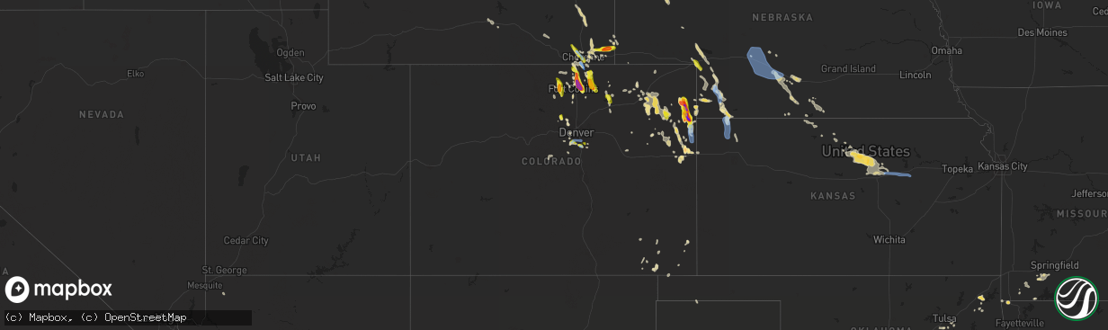
Hail Map in Colorado on July 27, 2022
The weather event in Colorado on July 27, 2022 includes Wind and Hail maps. 18 states and 293 cities were impacted and suffered possible damage. The total estimated number of properties impacted is 36,427.
Want more than just the map?
Turn this storm into a full workflow.
- Owner + property data so you know who to knock
- OnDemand branded weather history reports to win the "did we even have hail?" argument
- RoofTrace estimate so reps stop guessing numbers at the door
Bought this map? Upgrade within 7 days and we'll credit the $230. (10-15 min setup call)
Wind
Hail
36,427
Estimated number of impacted properties by a 1.00" hail or larger6,676
Estimated number of impacted properties by a 1.75" hail or larger1,915
Estimated number of impacted properties by a 2.50" hail or largerStorm reports in Colorado
Colorado
| Date | Description |
|---|---|
| 07/27/20226:48 PM CDT | Delayed report... With hail collected over an hour after the storm ended. Time estimated by radar. |
| 07/27/20226:25 PM CDT | Cocorahs co-we-409. 15 minutes of hail up to quarter size. |
| 07/27/20226:43 AM CDT | At 1143 PM MDT, a severe thunderstorm was located 4 miles north of Akron, moving east at 15 mph. HAZARD...60 mph wind gusts and half dollar size hail. SOURCE...Radar indicated. IMPACT...Expect damage to roofs, siding, and trees. Hail damage to vehicles is expected. This severe thunderstorm will be near... Akron around 1155 PM MDT. |
| 07/27/20226:27 AM CDT | At 1127 PM MDT, a severe thunderstorm was located over Chatfield Reservoir, or 13 miles southwest of Denver, moving east at 15 mph. HAZARD...60 mph wind gusts and quarter size hail. SOURCE...Radar indicated. IMPACT...Expect damage to roofs, siding, and trees. Hail damage to vehicles is expected. This severe thunderstorm will be near... Littleton and Sheridan around 1145 PM MDT.Other locations in the path of this severe thunderstorm includeLouviers, Sedalia, Centennial, Highlands Ranch, Greenwood Village,Lone Tree and Castle Pines. |
| 07/27/20226:15 AM CDT | At 1115 PM MDT, a severe thunderstorm was located near Otis, or 11 miles east of Akron, moving east at 10 mph. HAZARD...60 mph wind gusts and half dollar size hail. SOURCE...Radar indicated. IMPACT...Expect damage to roofs, siding, and trees. Hail damage to vehicles is expected. This severe thunderstorm will be near... Otis around 1130 PM MDT. |
| 07/27/20225:59 AM CDT | At 1059 PM MDT, a severe thunderstorm was located near Platner, or 8 miles east of Akron, moving east at 10 mph. HAZARD...60 mph wind gusts and half dollar size hail. SOURCE...Radar indicated. IMPACT...Expect damage to roofs, siding, and trees. Hail damage to vehicles is expected. Locations impacted include... Otis. |
| 07/27/20225:33 AM CDT | At 1033 PM MDT, a severe thunderstorm was located 15 miles west of Bonny Reservoir, moving southeast at 25 mph. HAZARD...60 mph wind gusts and quarter size hail. SOURCE...Radar indicated. IMPACT...Hail damage to vehicles is expected. Expect wind damage to roofs, siding, and trees. Locations impacted include... Bethune.This includes Highway 385 between mile markers 190 and 214. |
| 07/27/20225:26 AM CDT | At 1026 PM MDT, a severe thunderstorm was located 6 miles southwest of Burdett, or 13 miles northeast of Akron, moving east at 15 mph. HAZARD...Quarter size hail. SOURCE...Radar indicated. IMPACT...Damage to vehicles is expected. This severe thunderstorm will be near... Burdett around 1045 PM MDT.Other locations in the path of this severe thunderstorm include LoneStar. |
| 07/27/20224:57 AM CDT | At 957 PM MDT, severe thunderstorms were located along a line extending from near Hillsdale to 9 miles east of North Cheyenne to Ranchettes, moving south at 30 mph. HAZARD...60 mph wind gusts. SOURCE...Radar indicated. IMPACT...Expect damage to roofs, siding, and trees. Locations impacted include... Cheyenne, North Cheyenne, Hillsdale, Ranchettes, South Greeley and Fox Farm-College.This includes Interstate 80 in Wyoming between mile markers 363 and383. |
| 07/27/20224:39 AM CDT | At 939 PM MDT, a severe thunderstorm was located over Crisman, or 29 miles northwest of Denver, moving southeast at 20 mph. HAZARD...Quarter size hail. SOURCE...Radar indicated. IMPACT...Damage to vehicles is expected. Locations impacted include... Boulder, Eldorado Springs, Louisville and Lafayette. |
| 07/27/20224:22 AM CDT | At 921 PM MDT, a severe thunderstorm was located 5 miles north of Burdett, or 17 miles southeast of Sterling, moving southeast at 10 mph. HAZARD...Quarter size hail. SOURCE...Radar indicated. IMPACT...Damage to vehicles is expected. This severe thunderstorm will be near... Burdett around 935 PM MDT.Other locations in the path of this severe thunderstorm include LoneStar. |
| 07/27/20224:11 AM CDT | At 911 PM MDT, a severe thunderstorm was located near Drake, or 15 miles southwest of Fort Collins, moving southeast at 20 mph. HAZARD...Quarter size hail. SOURCE...Radar indicated. IMPACT...Damage to vehicles is expected. This severe thunderstorm will be near... Drake around 915 PM MDT. Cedar Cove around 925 PM MDT.Other locations in the path of this severe thunderstorm includeCarter Lake and Pinewood Springs. |
| 07/27/20223:50 AM CDT | 1 maple and two pine trees knocked down. Time from radar. |
| 07/27/20223:42 AM CDT | At 842 PM MDT, a severe thunderstorm was located 5 miles west of Yuma, or near Hyde, and was near stationary. HAZARD...60 mph wind gusts and half dollar size hail. SOURCE...Radar indicated. IMPACT...Expect damage to roofs, siding, and trees. Hail damage to vehicles is expected. This severe thunderstorm will remain over mainly rural areas of east central Washington County, including the following locations... Hyde. |
| 07/27/20223:22 AM CDT | At 822 PM MDT, a severe thunderstorm was located near Stove Prairie, or 18 miles west of Fort Collins, moving south at 25 mph. HAZARD...60 mph wind gusts and quarter size hail. SOURCE...Radar indicated. IMPACT...Expect damage to roofs, siding, and trees. Hail damage to vehicles is expected. This severe thunderstorm will be near... Buckhorn Mountain around 830 PM MDT.Other locations in the path of this severe thunderstorm include GlenHaven and Masonville. |
| 07/27/20223:20 AM CDT | Tree branch broken off. Time from radar. |
| 07/27/20223:14 AM CDT | At 814 PM MDT, a severe thunderstorm was located 10 miles south of Yuma, moving southeast at 20 mph. HAZARD...60 mph wind gusts and quarter size hail. SOURCE...Radar indicated. IMPACT...Hail damage to vehicles is expected. Expect wind damage to roofs, siding, and trees. This severe thunderstorm will remain over mainly rural areas of southwestern Yuma County, including the following locations... Abarr and Heartstrong. |
| 07/27/20223:03 AM CDT | At 803 PM MDT, a severe thunderstorm was located over Big Springs, moving southeast at 35 mph. HAZARD...60 mph wind gusts and half dollar size hail. SOURCE...Radar indicated. IMPACT...Hail damage to vehicles is expected. Expect wind damage to roofs, siding, and trees. Locations impacted include... Big Springs, Venango and Brandon. This includes Interstate 80 in Nebraska between mile markers 106 and117. |
| 07/27/20223:02 AM CDT | At 801 PM MDT, a severe thunderstorm was located 4 miles northwest of Severance, or 8 miles east of Fort Collins, moving south at 25 mph. THIS IS A DESTRUCTIVE STORM FOR SEVERANCE, WINDSOR, TIMNATH. HAZARD...Three inch hail and 60 mph wind gusts. SOURCE...Radar indicated. IMPACT...People and animals outdoors will be severely injured. Expect shattered windows, extensive damage to roofs, siding, and vehicles. This severe thunderstorm will be near... Severance around 805 PM MDT. Windsor and Timnath around 810 PM MDT. Greeley and northeastern Loveland around 820 PM MDT.Other locations in the path of this severe thunderstorm includeMilliken and Johnstown. |
| 07/27/20222:43 AM CDT | At 743 PM MDT, a severe thunderstorm was located over Purcell, or 16 miles north of Greeley, moving south at 25 mph. HAZARD...60 mph wind gusts and half dollar size hail. SOURCE...Radar indicated. IMPACT...Expect damage to roofs, siding, and trees. Hail damage to vehicles is expected. This severe thunderstorm will be near... Ault around 750 PM MDT. Eaton around 800 PM MDT.Other locations in the path of this severe thunderstorm includeGaleton, eastern Greeley, Lucerne, Barnesville, Gill, Evans andKersey. |
| 07/27/20222:27 AM CDT | At 727 PM MDT, a severe thunderstorm was located 6 miles north of Wellington, or 17 miles north of Fort Collins, moving southeast at 25 mph. HAZARD...60 mph wind gusts and quarter size hail. SOURCE...Radar indicated. IMPACT...Expect damage to roofs, siding, and trees. Hail damage to vehicles is expected. This severe thunderstorm will be near... Wellington around 735 PM MDT.Other locations in the path of this severe thunderstorm include Nunnand Pierce. |
| 07/27/20222:21 AM CDT | At 720 PM MDT, a severe thunderstorm was located over Yuma, moving southeast at 20 mph. HAZARD...60 mph wind gusts and half dollar size hail. SOURCE...Radar indicated. IMPACT...Hail damage to vehicles is expected. Expect wind damage to roofs, siding, and trees. This severe thunderstorm will remain over mainly rural areas of northwestern Yuma County, including the following locations... Heartstrong and Vernon. |
| 07/27/20222:06 AM CDT | At 706 PM MDT, a severe thunderstorm was located 7 miles southeast of Rockport, or 22 miles south of Cheyenne, moving southeast at 25 mph. HAZARD...60 mph wind gusts and quarter size hail. SOURCE...Radar indicated. IMPACT...Expect damage to roofs, siding, and trees. Hail damage to vehicles is expected. Locations impacted include... Purcell. |
| 07/27/20221:51 AM CDT | At 651 PM MDT, a severe thunderstorm was located 5 miles southwest of Natural Fort, or 19 miles southwest of Cheyenne, moving south at 20 mph. HAZARD...60 mph wind gusts and quarter size hail. SOURCE...Radar indicated. IMPACT...Expect damage to roofs, siding, and trees. Hail damage to vehicles is expected. Locations impacted include... Wellington and Nunn. |
| 07/27/20221:15 AM CDT | A local report indicates 1.00 inch wind near 2 S AKRON |
| 07/27/202212:58 AM CDT | At 558 PM MDT, a severe thunderstorm was located near Purcell, or 15 miles northeast of Greeley, moving southeast at 25 mph. HAZARD...Golf ball size hail. SOURCE...Radar indicated. IMPACT...People and animals outdoors will be injured. Expect damage to roofs, siding, windows, and vehicles. This severe thunderstorm will be near... Galeton around 605 PM MDT.Other locations in the path of this severe thunderstorm includeBarnesville, Gill and Kersey. |
| 07/27/202212:44 AM CDT | Report from mping: quarter |
| 07/27/202212:33 AM CDT | Mesonet station co073 1.2 mi n of castle pines parkway. Also recorded a sustained wind of 47mph. |
| 07/27/202212:28 AM CDT | Report from mping: quarter |
| 07/27/202212:25 AM CDT | At 525 PM MDT, a severe thunderstorm was located 5 miles northeast of Nunn, or 23 miles northeast of Fort Collins, moving south at 20 mph. HAZARD...Half dollar size hail. SOURCE...Radar indicated. IMPACT...Damage to vehicles is expected. This severe thunderstorm will be near... Nunn around 530 PM MDT. Pierce around 545 PM MDT.Other locations in the path of this severe thunderstorm includePurcell, Ault and Eaton. |
| 07/27/202212:23 AM CDT | A local report indicates 1.00 inch wind near 2 WNW HIGHLANDS RANCH |
| 07/27/202212:23 AM CDT | At 522 PM MDT, a severe thunderstorm was located near Federal, or 12 miles northwest of Cheyenne, moving southeast at 25 mph. HAZARD...60 mph wind gusts and quarter size hail. SOURCE...Radar indicated. IMPACT...Hail damage to vehicles is expected. Expect wind damage to roofs, siding, and trees. Locations impacted include... Cheyenne, South Greeley, Federal, Warren AFB, Frontier Park, Warren Af Base, Ranchettes, Fox Farm-College and South Greeley High.This includes the following highways... Interstate 25 in Wyoming between mile markers 1 and 12. Interstate 80 in Wyoming between mile markers 349 and 362. |
| 07/27/202212:15 AM CDT | Delayed social media report. 2 miles south of hen egg hail report. Hail up to golf ball size... With lots of wind too. Branches down and considerable damage to crops. |
| 07/27/202212:10 AM CDT | Delayed social media report. 8 miles north and 5 miles west of burlington. Report of 1.75 inches of rain... Marble to hen egg size hail... Winds over 60 mph... And some |
| 07/27/202212:10 AM CDT | Delayed social media report. 8 miles north and 5 miles west of burlington. Report of 1.75 inches of rain... Marble to hen egg size hail... Winds over 60 mph... And some |
| 07/27/202212:09 AM CDT | Mesonet station co007 littleton c470/wadsworth. |
| 07/26/202211:26 PM CDT | At 426 PM MDT, a severe thunderstorm was located near Natural Fort, or 10 miles southwest of Cheyenne, moving southeast at 20 mph. HAZARD...60 mph wind gusts and penny size hail. SOURCE...Radar indicated. IMPACT...Expect damage to roofs, siding, and trees. Locations impacted include... South Greeley and Fox Farm-College. This includes Interstate 25 in Wyoming between mile markers 1 and 3. |
| 07/26/202211:00 PM CDT | A local report indicates 1.00 inch wind near 2 SW WALLSTREET |
| 07/26/202210:47 PM CDT | Mesonet station co047 385n220 idalia. |
| 07/26/202210:24 PM CDT | Social media report of pea size and quarter size hail at beecher island. |
| 07/26/20229:50 PM CDT | Nickel and quarter sized hail. |
| 07/26/20229:49 PM CDT | Hail up to quarter size. |
| 07/26/20229:48 PM CDT | Relayed report from the crystal mountain area. Also recorded over a half inch of rain in 15 minutes. Time estimated. |
| 07/26/20229:43 PM CDT | Delayed report... Reported that they were able to measure 1.75 inch hail but hail was likely larger before they got to it. Also reported storm total rainfall of 1.23 in |
| 07/26/20229:37 PM CDT | Photo of 1.6 inch diameter hail. |
| 07/26/20229:35 PM CDT | Report via social media with a |
| 07/26/20229:35 PM CDT | Report of hail up to quarter inch. |
| 07/26/20229:35 PM CDT | Report via social media with a photo of golf-ball sized hail 7 miles south of wray... Co on highway 385. Timing... Location... And magnitude are estimated. |
| 07/26/20229:30 PM CDT | Delayed social media report. Mixed hail of half to three quarters of an inch... With some stones as large as half dollar. |
| 07/26/20229:30 PM CDT | Public report via photo on social media of a 3 inch maximum diameter hail stone. Photo had the stone next to a tape measure. Location was at the intersection of county |
| 07/26/20229:27 PM CDT | A local report indicates 1.75 inch wind near SEVERANCE |
| 07/26/20229:17 PM CDT | Corrects previous hail report from 3 w wray. Public report via social media with a photo of slightly smaller than tennis ball sized hail on the west side of wray... Co. |
| 07/26/20229:17 PM CDT | Public report via social media with a photo of slightly smaller than tennis ball sized hail on the west side of wray... Co. Location and size are estimated. |
| 07/26/20229:15 PM CDT | Public report relayed via social media. Photo of hail stone next to a quarter. |
| 07/26/20229:15 PM CDT | Cocorahs co-we-564. |
| 07/26/20229:08 PM CDT | Photos of hail at the intersection of mulberry street and county road 15. Time estimated. |
| 07/26/20229:02 PM CDT | Off-duty nws employee provided photos of tennis ball size hail... Measured 45 minutes after the hail stopped falling. |
| 07/26/20229:00 PM CDT | Hail blown into house causing some damage. Tree limbs also down. |
| 07/26/20229:00 PM CDT | Large tree limbs down. |
| 07/26/20228:53 PM CDT | Larimer dispatch relayed report of significant damage... Including smashed windows... As a result of the hail. Time estimated. |
| 07/26/20228:47 PM CDT | Report relayed from spotter. |
| 07/26/20228:47 PM CDT | Report via twitter. Time estimated. |
| 07/26/20228:45 PM CDT | Up to ping pong ball sized hail. The hail damaged at least one window. Time estimated. |
| 07/26/20228:45 PM CDT | Cocorahs co-lr-1146. Reported car dents and damaged shingles. |
| 07/26/20228:44 PM CDT | Falling at time of report. |
| 07/26/20228:41 PM CDT | A local report indicates 1.00 inch wind near 1 NW WELLINGTON |
| 07/26/20228:39 PM CDT | A local report indicates 1.25 inch wind near 3 NE WELLINGTON |
| 07/26/20228:35 PM CDT | Cocorahs co-lr-142. |
| 07/26/20228:30 PM CDT | Corrects previous hail report from 6 wsw wauneta. Public report via photo on social media of a hail stone next to a tape measure. At maximum diameter... The hail stone |
| 07/26/20228:30 PM CDT | Public report via photo on social media of a hail stone next to a tape measure. At maximum diameter... The hail stone seems to be around 3.75 inches. Location was near |
| 07/26/20227:08 PM CDT | A local report indicates 1.00 inch wind near 2 N GALETON |
| 07/26/20227:03 PM CDT | Storm chaser reported hail at the intersection of state highway 14 and county road 49. Time estimated by radar. |
All States Impacted by Hail Map on July 27, 2022
Cities Impacted by Hail Map on July 27, 2022
- Wellington, CO
- Cheyenne, WY
- Portis, KS
- Peetz, CO
- Iliff, CO
- Morgantown, KY
- Jetson, KY
- Fairmont, MN
- Welcome, MN
- Eaton, CO
- Ault, CO
- Gill, CO
- Pierce, CO
- Nunn, CO
- Jackson, MN
- Alpha, MN
- Briggsdale, CO
- Sherburn, MN
- Grant, NE
- Parks, NE
- Champion, NE
- Haigler, NE
- Benkelman, NE
- North Platte, NE
- Oshkosh, NE
- Venango, NE
- Big Springs, NE
- Julesburg, CO
- Pine Bluffs, WY
- Albin, WY
- Harrisburg, NE
- Burns, WY
- Ellsworth, NE
- Hemingford, NE
- Alliance, NE
- Livermore, CO
- Laramie, WY
- Lexington, NE
- Carpenter, WY
- Joes, CO
- Anton, CO
- Vona, CO
- Cope, CO
- Bellvue, CO
- Callaway, NE
- Gothenburg, NE
- Roggen, CO
- Orchard, CO
- Jadwin, MO
- Salem, MO
- Austin, MN
- Hollandale, MN
- Littlefield, AZ
- Parker, CO
- Imperial, NE
- Yuma, CO
- Wray, CO
- Idalia, CO
- Holyoke, CO
- Vernon, CO
- Wheatland, WY
- Chugwater, WY
- Fort Collins, CO
- Kim, CO
- Oxford, NC
- Lewellen, NE
- Ogallala, NE
- Brule, NE
- Brady, NE
- Pritchett, CO
- Hillsdale, WY
- Akron, CO
- Merino, CO
- Rawlins, WY
- Whiting, IN
- East Chicago, IN
- Chicago, IL
- Hammond, IN
- Holdrege, NE
- Arriba, CO
- Dammeron Valley, UT
- Saint George, UT
- Gunlock, UT
- Wilcox, NE
- Cozad, NE
- Elwood, NE
- Eustis, NE
- Oxford, NE
- Bertrand, NE
- Edison, NE
- Murray, KY
- Almo, KY
- Dexter, KY
- Loveland, CO
- Bushnell, NE
- Texhoma, OK
- Stratford, TX
- Lander, WY
- Bixby, OK
- Kersey, CO
- Smithfield, NE
- Canadian, TX
- Overton, NE
- Stratton, CO
- Littleton, CO
- Gravette, AR
- Sulphur Springs, AR
- Wappapello, MO
- Puxico, MO
- Tipton, KS
- Glen Elder, KS
- Billings, MO
- Clever, MO
- Crane, MO
- Marionville, MO
- Aurora, MO
- Vinita, OK
- Strang, OK
- Burlington, CO
- Caliente, NV
- Minneapolis, KS
- Glenpool, OK
- Sapulpa, OK
- Cawker City, KS
- Mount Carmel, UT
- Orderville, UT
- Glasgow, KY
- Glasco, KS
- Delphos, KS
- Beloit, KS
- Barnard, KS
- Windsor, CO
- Greeley, CO
- Carr, CO
- Severance, CO
- Carrizozo, NM
- Granada, CO
- Bethune, CO
- Max, NE
- Morrison, CO
- Evergreen, CO
- Kanorado, KS
- Calvert City, KY
- Symsonia, KY
- Paducah, KY
- Madrid, NE
- Big Cabin, OK
- Young, AZ
- Stratton, NE
- McDonald, KS
- Kirk, CO
- Eddyville, KY
- Kuttawa, KY
- Sterling, CO
- Otis, CO
- Las Animas, CO
- Wiggins, CO
- Downs, KS
- Tescott, KS
- New Cambria, KS
- Solomon, KS
- Hunter, KS
- Lincoln, KS
- Salina, KS
- Bennington, KS
- Raton, NM
- Evans, CO
- Afton, OK
- Ketchum, OK
- Rochester, KY
- Broken Arrow, OK
- Bradford, AR
- Boulder, CO
- Cromwell, KY
- Beaver Dam, KY
- Eagle Rock, MO
- Hockley, TX
- Waller, TX
- Drake, CO
- Estes Park, CO
- Sinclair, WY
- Nederland, CO
- Phillipsburg, KS
- Lewisburg, KY
- Russellville, KY
- Enders, NE
- Wauneta, NE
- Berthoud, CO
- Gaylord, KS
- Agate, CO
- Jefferson, CO
- Lake George, CO
- Hillrose, CO
- Salina, OK
- Cave In Rock, IL
- Rocky Comfort, MO
- Pryor, OK
- Edmonton, KY
- Knob Lick, KY
- Ellsinore, MO
- Van Buren, MO
- Mill Spring, MO
- Piedmont, MO
- Ellington, MO
- South West City, MO
- Arvada, CO
- Tombstone, AZ
- Eckley, CO
- Franklin, KY
- Portland, TN
- Franklin, NE
- Bloomington, NE
- Tulsa, OK
- Conifer, CO
- Sedalia, CO
- Little Rock, AR
- Castle Rock, CO
- Lone Tree, CO
- Hendley, NE
- Golden, CO
- Denver, CO
- Show Low, AZ
- Two Buttes, CO
- Doniphan, MO
- Agra, KS
- Boise City, OK
- Atwood, KS
- Bowling Green, KY
- Rockfield, KY
- Alton, MO
- Kimball, NE
- Claunch, NM
- Snyder, CO
- Booneville, KY
- Globe, AZ
- Peridot, AZ
- Hurricane, UT
- Beaver City, NE
- Woodrow, CO
- Spavinaw, OK
- Roundhill, KY
- Broomfield, CO
- Louisville, CO
- Eldorado Springs, CO
- Semora, NC
- Fort Morgan, CO
- Alma, NE
- Naponee, NE
- Republican City, NE
- Jenks, OK
- Kiefer, OK
- Purdy, MO
- Monett, MO
- Butterfield, MO
- Pierce City, MO
- West Liberty, KY
- Mize, KY
- Ezel, KY
- Grenville, NM
- Campo, CO
- McKee, KY
- Tyner, KY
- Vincent, KY
- Warrenton, NC
- Amarillo, TX
- Saint Johns, AZ
- Timnath, CO
- Fort Washakie, WY
- Albert Lea, MN
- Freeborn, MN
- Alden, MN
- Blooming Prairie, MN
- Hartland, MN
- Clarks Grove, MN
- Bosler, WY
- Granite Canon, WY
- Fe Warren Afb, WY
- Englewood, CO
- Wellfleet, NE
- Farnam, NE
- Moorefield, NE
- Curtis, NE
- Stapleton, NE
- Maxwell, NE
- Junction City, KS
- Abilene, KS
- Enterprise, KS
- Chapman, KS
- Galeton, CO
- Irvine, KY
- Clay City, KY
- Stanton, KY
- Winchester, KY


