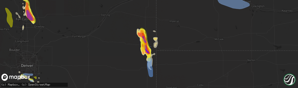
Hail Map in Wray, CO on July 27, 2022
The weather event in Wray, CO on July 27, 2022 includes Wind and Hail maps. 18 states and 293 cities were impacted and suffered possible damage. The total estimated number of properties impacted is 2,291.
Wind
Hail
2,291
Estimated number of impacted properties by a 1.00" hail or larger423
Estimated number of impacted properties by a 1.75" hail or larger150
Estimated number of impacted properties by a 2.50" hail or largerStorm reports in Wray, CO
Wray, CO
| Date | Description |
|---|---|
| 07/26/202210:24 PM CDT | Social media report of pea size and quarter size hail at beecher island. |
| 07/26/20229:50 PM CDT | Nickel and quarter sized hail. |
| 07/26/20229:49 PM CDT | Hail up to quarter size. |
| 07/26/20229:43 PM CDT | Delayed report... Reported that they were able to measure 1.75 inch hail but hail was likely larger before they got to it. Also reported storm total rainfall of 1.23 in |
| 07/26/20229:35 PM CDT | Report via social media with a photo of golf-ball sized hail 7 miles south of wray... Co on highway 385. Timing... Location... And magnitude are estimated. |
| 07/26/20229:35 PM CDT | Report of hail up to quarter inch. |
| 07/26/20229:35 PM CDT | Report via social media with a |
| 07/26/20229:30 PM CDT | Public report via photo on social media of a 3 inch maximum diameter hail stone. Photo had the stone next to a tape measure. Location was at the intersection of county |
| 07/26/20229:30 PM CDT | Delayed social media report. Mixed hail of half to three quarters of an inch... With some stones as large as half dollar. |
| 07/26/20229:17 PM CDT | Public report via social media with a photo of slightly smaller than tennis ball sized hail on the west side of wray... Co. Location and size are estimated. |
| 07/26/20229:17 PM CDT | Corrects previous hail report from 3 w wray. Public report via social media with a photo of slightly smaller than tennis ball sized hail on the west side of wray... Co. |
| 07/26/20229:15 PM CDT | Public report relayed via social media. Photo of hail stone next to a quarter. |
| 07/26/20228:30 PM CDT | Public report via photo on social media of a hail stone next to a tape measure. At maximum diameter... The hail stone seems to be around 3.75 inches. Location was near |
| 07/26/20228:30 PM CDT | Corrects previous hail report from 6 wsw wauneta. Public report via photo on social media of a hail stone next to a tape measure. At maximum diameter... The hail stone |
All States Impacted by Hail Map on July 27, 2022
All Cities Impacted by Hail Map on July 27, 2022
- Wellington, CO
- Cheyenne, WY
- Portis, KS
- Peetz, CO
- Iliff, CO
- Morgantown, KY
- Jetson, KY
- Fairmont, MN
- Welcome, MN
- Eaton, CO
- Ault, CO
- Gill, CO
- Pierce, CO
- Nunn, CO
- Jackson, MN
- Alpha, MN
- Briggsdale, CO
- Sherburn, MN
- Grant, NE
- Parks, NE
- Champion, NE
- Haigler, NE
- Benkelman, NE
- North Platte, NE
- Oshkosh, NE
- Venango, NE
- Big Springs, NE
- Julesburg, CO
- Pine Bluffs, WY
- Albin, WY
- Harrisburg, NE
- Burns, WY
- Ellsworth, NE
- Hemingford, NE
- Alliance, NE
- Livermore, CO
- Laramie, WY
- Lexington, NE
- Carpenter, WY
- Joes, CO
- Anton, CO
- Vona, CO
- Cope, CO
- Bellvue, CO
- Callaway, NE
- Gothenburg, NE
- Roggen, CO
- Orchard, CO
- Jadwin, MO
- Salem, MO
- Austin, MN
- Hollandale, MN
- Littlefield, AZ
- Parker, CO
- Imperial, NE
- Yuma, CO
- Wray, CO
- Idalia, CO
- Holyoke, CO
- Vernon, CO
- Wheatland, WY
- Chugwater, WY
- Fort Collins, CO
- Kim, CO
- Oxford, NC
- Lewellen, NE
- Ogallala, NE
- Brule, NE
- Brady, NE
- Pritchett, CO
- Hillsdale, WY
- Akron, CO
- Merino, CO
- Rawlins, WY
- Whiting, IN
- East Chicago, IN
- Chicago, IL
- Hammond, IN
- Holdrege, NE
- Arriba, CO
- Dammeron Valley, UT
- Saint George, UT
- Gunlock, UT
- Wilcox, NE
- Cozad, NE
- Elwood, NE
- Eustis, NE
- Oxford, NE
- Bertrand, NE
- Edison, NE
- Murray, KY
- Almo, KY
- Dexter, KY
- Loveland, CO
- Bushnell, NE
- Texhoma, OK
- Stratford, TX
- Lander, WY
- Bixby, OK
- Kersey, CO
- Smithfield, NE
- Canadian, TX
- Overton, NE
- Stratton, CO
- Littleton, CO
- Gravette, AR
- Sulphur Springs, AR
- Wappapello, MO
- Puxico, MO
- Tipton, KS
- Glen Elder, KS
- Billings, MO
- Clever, MO
- Crane, MO
- Marionville, MO
- Aurora, MO
- Vinita, OK
- Strang, OK
- Burlington, CO
- Caliente, NV
- Minneapolis, KS
- Glenpool, OK
- Sapulpa, OK
- Cawker City, KS
- Mount Carmel, UT
- Orderville, UT
- Glasgow, KY
- Glasco, KS
- Delphos, KS
- Beloit, KS
- Barnard, KS
- Windsor, CO
- Greeley, CO
- Carr, CO
- Severance, CO
- Carrizozo, NM
- Granada, CO
- Bethune, CO
- Max, NE
- Morrison, CO
- Evergreen, CO
- Kanorado, KS
- Calvert City, KY
- Symsonia, KY
- Paducah, KY
- Madrid, NE
- Big Cabin, OK
- Young, AZ
- Stratton, NE
- McDonald, KS
- Kirk, CO
- Eddyville, KY
- Kuttawa, KY
- Sterling, CO
- Otis, CO
- Las Animas, CO
- Wiggins, CO
- Downs, KS
- Tescott, KS
- New Cambria, KS
- Solomon, KS
- Hunter, KS
- Lincoln, KS
- Salina, KS
- Bennington, KS
- Raton, NM
- Evans, CO
- Afton, OK
- Ketchum, OK
- Rochester, KY
- Broken Arrow, OK
- Bradford, AR
- Boulder, CO
- Cromwell, KY
- Beaver Dam, KY
- Eagle Rock, MO
- Hockley, TX
- Waller, TX
- Drake, CO
- Estes Park, CO
- Sinclair, WY
- Nederland, CO
- Phillipsburg, KS
- Lewisburg, KY
- Russellville, KY
- Enders, NE
- Wauneta, NE
- Berthoud, CO
- Gaylord, KS
- Agate, CO
- Jefferson, CO
- Lake George, CO
- Hillrose, CO
- Salina, OK
- Cave In Rock, IL
- Rocky Comfort, MO
- Pryor, OK
- Edmonton, KY
- Knob Lick, KY
- Ellsinore, MO
- Van Buren, MO
- Mill Spring, MO
- Piedmont, MO
- Ellington, MO
- South West City, MO
- Arvada, CO
- Tombstone, AZ
- Eckley, CO
- Franklin, KY
- Portland, TN
- Franklin, NE
- Bloomington, NE
- Tulsa, OK
- Conifer, CO
- Sedalia, CO
- Little Rock, AR
- Castle Rock, CO
- Lone Tree, CO
- Hendley, NE
- Golden, CO
- Denver, CO
- Show Low, AZ
- Two Buttes, CO
- Doniphan, MO
- Agra, KS
- Boise City, OK
- Atwood, KS
- Bowling Green, KY
- Rockfield, KY
- Alton, MO
- Kimball, NE
- Claunch, NM
- Snyder, CO
- Booneville, KY
- Globe, AZ
- Peridot, AZ
- Hurricane, UT
- Beaver City, NE
- Woodrow, CO
- Spavinaw, OK
- Roundhill, KY
- Broomfield, CO
- Louisville, CO
- Eldorado Springs, CO
- Semora, NC
- Fort Morgan, CO
- Alma, NE
- Naponee, NE
- Republican City, NE
- Jenks, OK
- Kiefer, OK
- Purdy, MO
- Monett, MO
- Butterfield, MO
- Pierce City, MO
- West Liberty, KY
- Mize, KY
- Ezel, KY
- Grenville, NM
- Campo, CO
- McKee, KY
- Tyner, KY
- Vincent, KY
- Warrenton, NC
- Amarillo, TX
- Saint Johns, AZ
- Timnath, CO
- Fort Washakie, WY
- Albert Lea, MN
- Freeborn, MN
- Alden, MN
- Blooming Prairie, MN
- Hartland, MN
- Clarks Grove, MN
- Bosler, WY
- Granite Canon, WY
- Fe Warren Afb, WY
- Englewood, CO
- Wellfleet, NE
- Farnam, NE
- Moorefield, NE
- Curtis, NE
- Stapleton, NE
- Maxwell, NE
- Junction City, KS
- Abilene, KS
- Enterprise, KS
- Chapman, KS
- Galeton, CO
- Irvine, KY
- Clay City, KY
- Stanton, KY
- Winchester, KY


