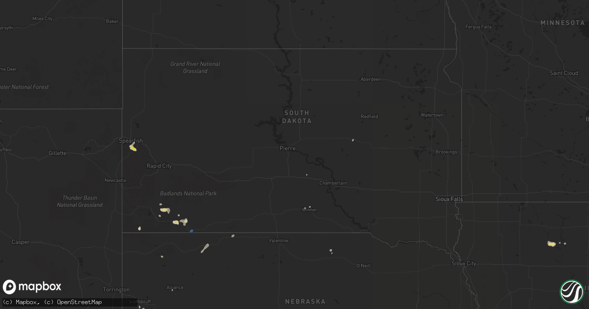
Hail Map in South Dakota on July 27, 2019
Get this storm
July 27 map
$229
one time, instant access
Download today. No call, no setup
Keep the $229
Bought the map and want the full workflow? Apply the entire $229 to a subscription within 7 days. None of it is wasted.
Every map, not just this one
This buys you this map. Subscription and you get every map we run, in the markets you choose from a few cities to whole states to nationwide. Plus real-time alerts the moment a storm fires.
Contact data
Name, contact info, occupancy, even credit band for addresses in the footprint. You go from where it hit to who to call.
Become the source they trust
Unlimited branding weather history reports on demand. You already have the documented answer ready for the property owner, and you are the one who showed up with it.
Property data and RoofTrace estimates
Pull up any address you have got, its value and the exact code rules for that jurisdiction, straight from One Click Code. Then RoofTrace estimates the squares, pitch, and roof value, priced the way you price.
Storm reports in South Dakota
South Dakota
| Date | Description |
|---|---|
| 07/27/20193:10 PM CDT | A local report indicates 1.00 inch wind near 3 NW CENTRAL CITY |
| 07/27/20192:38 PM CDT | Mping report |
| 07/27/20192:28 PM CDT | Mostly pea sized hail... Some as large as a quarter. |
| 07/26/20198:44 PM CDT | At 143 PM MDT, a severe thunderstorm was located over Bridal Veil Falls, or 5 miles northwest of Lead, moving east at 15 mph. HAZARD...Half dollar size hail. SOURCE...Radar indicated. IMPACT...Damage to vehicles is expected. Locations impacted include... Deadwood, Bridal Veil Falls and eastern Spearfish Canyon. |
| 07/26/20198:21 PM CDT | At 120 PM MDT, a severe thunderstorm was located over Central City, or near Lead, moving southeast at 10 mph. HAZARD...Half dollar size hail. SOURCE...Radar indicated. IMPACT...Damage to vehicles is expected. Locations impacted include... Lead, Deadwood, Central City, Brownsville, Galena and Terry Peak. |
| 07/26/20197:49 PM CDT | A local report indicates 62 MPH wind near 3 ESE PINE RIDGE |
All States Impacted by Hail Map on July 27, 2019
Cities Impacted by Hail Map on July 27, 2019
- Bradgate, IA
- Rolfe, IA
- Southwick, MA
- Iliff, CO
- Crook, CO
- Montrose, CO
- Oral, SD
- Ottosen, IA
- Rutland, IA
- Gordon, NE
- Winner, SD
- Saint Helen, MI
- Lead, SD
- Barkhamsted, CT
- Canton, CT
- Pine Ridge, SD
- West Branch, MI
- Roscommon, MI
- Houghton Lake, MI
- Tererro, NM
- Merriman, NE
- Sidney, NE
- Keystone, IA
- Model, CO
- Fowler, CO
- Newport, NE
- Livingston, MT
- Marshalltown, IA
- Spearfish, SD
- Deadwood, SD
- Palmer Lake, CO
- Monument, CO
- Harrisburg, NE
- Buffalo Gap, SD
- Edgemont, SD
- Hale, MI
- Traer, IA
- Kennebec, SD
- Crawford, NE
- Chelsea, IA
- Gladbrook, IA
- Garwin, IA
- Gering, NE
- Rocky Ford, CO
- Pentwater, MI
- Manton, MI
- Dix, NE
- Humboldt, IA
- Bode, IA
- Pecos, NM
- Saint Lawrence, SD
- Larkspur, CO
- Smithwick, SD
- Lupton, MI
- Toledo, IA
- Bassett, NE
- Avon, CT
- Livermore, IA
- Hart, MI
- Florence, CO
- Alliance, NE
- Rose City, MI
- Luzerne, IA
- Blairstown, IA
- Oglala, SD
- Lodgepole, NE
- Elmwood, WI
- Spring Valley, WI
- Tawas City, MI
- Whittemore, MI
- National City, MI
- East Tawas, MI
- Coventry, CT
- Storrs Mansfield, CT


