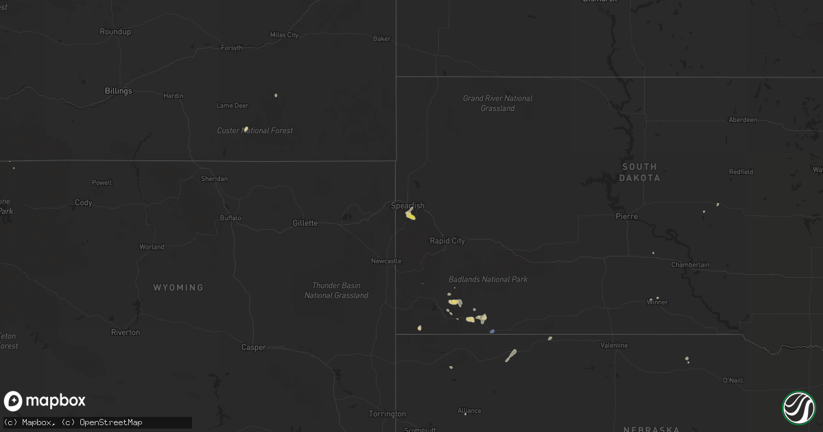
Hail Map on July 27, 2019
Get this storm
July 27 map
$229
one time, instant access
Download today. No call, no setup
Keep the $229
Bought the map and want the full workflow? Apply the entire $229 to a subscription within 7 days. None of it is wasted.
Every map, not just this one
This buys you this map. Subscription and you get every map we run, in the markets you choose from a few cities to whole states to nationwide. Plus real-time alerts the moment a storm fires.
Contact data
Name, contact info, occupancy, even credit band for addresses in the footprint. You go from where it hit to who to call.
Become the source they trust
Unlimited branding weather history reports on demand. You already have the documented answer ready for the property owner, and you are the one who showed up with it.
Property data and RoofTrace estimates
Pull up any address you have got, its value and the exact code rules for that jurisdiction, straight from One Click Code. Then RoofTrace estimates the squares, pitch, and roof value, priced the way you price.
States Impacted by Hail Map on July 27, 2019
Storm reports
Minnesota
| Date | Description |
|---|---|
| 07/27/20197:15 AM CDT | At 1215 AM CDT, a severe thunderstorm was located near Warsaw, or 7 miles west of Faribault, moving southeast at 30 mph. HAZARD...60 mph wind gusts and half dollar size hail. SOURCE...Radar indicated. IMPACT...Hail damage to vehicles is expected. Expect wind damage to roofs, siding, and trees. Locations impacted include... Faribault, Northfield, Waterville, Dundas, Medford, Morristown, Warsaw, Nerstrand, Bridgewater, Clinton Falls, Merton and Moland.This includes Interstate 35 between mile markers 45 and 66. |
Idaho
| Date | Description |
|---|---|
| 07/27/20195:20 PM CDT | Mesonet station sum big southern summit. |
| 07/26/20198:45 PM CDT | About 200 people reported without power in the area of holmes and cleveland. Time based on radar. |
South Dakota
| Date | Description |
|---|---|
| 07/27/20193:10 PM CDT | A local report indicates 1.00 inch wind near 3 NW CENTRAL CITY |
| 07/27/20192:38 PM CDT | Mping report |
| 07/27/20192:28 PM CDT | Mostly pea sized hail... Some as large as a quarter. |
| 07/26/20198:44 PM CDT | At 143 PM MDT, a severe thunderstorm was located over Bridal Veil Falls, or 5 miles northwest of Lead, moving east at 15 mph. HAZARD...Half dollar size hail. SOURCE...Radar indicated. IMPACT...Damage to vehicles is expected. Locations impacted include... Deadwood, Bridal Veil Falls and eastern Spearfish Canyon. |
| 07/26/20198:21 PM CDT | At 120 PM MDT, a severe thunderstorm was located over Central City, or near Lead, moving southeast at 10 mph. HAZARD...Half dollar size hail. SOURCE...Radar indicated. IMPACT...Damage to vehicles is expected. Locations impacted include... Lead, Deadwood, Central City, Brownsville, Galena and Terry Peak. |
| 07/26/20197:49 PM CDT | A local report indicates 62 MPH wind near 3 ESE PINE RIDGE |
New York
| Date | Description |
|---|---|
| 07/27/20191:09 PM CDT | Multiple trees down. |
| 07/27/20191:07 PM CDT | Tree down. |
| 07/26/20199:04 PM CDT | At 204 PM EDT, a severe thunderstorm was located over Saugerties, and is nearly stationary. HAZARD...60 mph wind gusts and quarter size hail. SOURCE...Radar indicated. IMPACT...Hail damage to vehicles is expected. Expect wind damage to roofs, siding, and trees. This severe thunderstorm will remain over mainly rural areas of northeastern Ulster, west central Columbia and southeastern Greene Counties, including the following locations... Asbury, Canoe Hill, Quarryville, Manorville, Katsbaan, Burden, Germantown, Blue Mountain, Cheviot and Veteran. |
Colorado
| Date | Description |
|---|---|
| 07/27/20192:37 AM CDT | At 737 PM MDT, a severe thunderstorm was located near Twin Buttes, or 15 miles southeast of Sidney, moving east at 25 mph. HAZARD...Golf ball size hail and 60 mph wind gusts. SOURCE...Radar indicated. IMPACT...Expect damage to roofs, siding, and trees. People and animals outdoors will be injured. Expect hail damage to roofs, siding, windows, and vehicles. Locations impacted include... Sedgwick, Crook and Twin Buttes. |
| 07/27/20192:35 AM CDT | At 735 PM MDT, a severe thunderstorm was located near Twin Buttes, or 14 miles southeast of Sidney, moving northeast at 30 mph. HAZARD...Ping pong ball size hail and 60 mph wind gusts. SOURCE...Radar indicated. IMPACT...People and animals outdoors will be injured. Expect hail damage to roofs, siding, windows, and vehicles. Expect wind damage to roofs, siding, and trees. This severe thunderstorm will be near... Lodgepole around 800 PM MDT.This includes Interstate 80 in Nebraska between mile markers 69 and77. |
| 07/27/20191:57 AM CDT | At 656 PM MDT, severe thunderstorms were located along a line extending from near Sugar City to 6 miles southwest of La Junta, moving east at 45 mph. HAZARD...60 mph wind gusts and penny size hail. SOURCE...Radar indicated. IMPACT...Expect damage to roofs, siding, and trees. Locations impacted include... La Junta, North La Junta, Rocky Ford, Las Animas, Ordway, Swink, Sugar City, Cheraw, McClave, Blue Lake, Hasty, Neegronda Reservoir, John Martin Reservoir, Sweetwater Reservoir, Caddoa and Fort Lyon. |
| 07/27/20191:04 AM CDT | At 603 PM MDT, severe thunderstorms were located along a line extending from 7 miles south of Hanover to near Blende, moving east at 45 mph. HAZARD...60 mph wind gusts. SOURCE...Radar indicated. IMPACT...Expect damage to roofs, siding, and trees. Locations impacted include... Pueblo, Olney Springs, Boone, Crowley, Blende, Avondale, Pueblo Depot, Salt Creek and Hanover. |
| 07/26/20198:07 PM CDT | A local report indicates 58 MPH wind near 4 S CHERAW |
Nebraska
| Date | Description |
|---|---|
| 07/26/20198:30 PM CDT | Garage damage... Power lines and tree branches downed. Time estimated. Delayed report. |
Wisconsin
| Date | Description |
|---|---|
| 07/27/20197:43 AM CDT | At 1243 AM CDT, a severe thunderstorm was located near Mondovi, moving southeast at 30 mph. HAZARD...60 mph wind gusts and half dollar size hail. SOURCE...Radar indicated. IMPACT...Hail damage to vehicles is expected. Expect wind damage to roofs, siding, and trees. This severe thunderstorm will be near... Strum around 115 AM CDT. Osseo around 125 AM CDT.Other locations impacted by this severe thunderstorm include Highway53 And County E, Mondovi Airfield, The Big Swamp Area and Eleva. |
| 07/27/20197:10 AM CDT | At 1210 AM CDT, a severe thunderstorm was located near Eau Galle, or 11 miles southwest of Menomonie, moving southeast at 30 mph. HAZARD...Golf ball size hail and 60 mph wind gusts. SOURCE...Radar indicated. IMPACT...People and animals outdoors will be injured. Expect hail damage to roofs, siding, windows, and vehicles. Expect wind damage to roofs, siding, and trees. Locations impacted include... Durand, Eau Galle and Downsville. |
Michigan
| Date | Description |
|---|---|
| 07/27/20192:24 PM CDT | Trees down on power lines...blocking road. |
| 07/27/20192:21 PM CDT | Corrects previous tstm wnd dmg report from national city. Trees and limbs down. |
| 07/27/20192:15 PM CDT | Power lines down. Time estimated via radar. |
| 07/27/20192:06 PM CDT | *** 1 inj *** trees down on vehicle in hale. 1 injury reported. |
| 07/27/20192:00 PM CDT | Trees and limbs down. |
| 07/27/20191:53 PM CDT | Trees down over power lines causing fire. |
| 07/27/20191:52 PM CDT | Large limbs down. |
| 07/27/20191:28 PM CDT | Trees down over power lines. |
| 07/26/20199:48 PM CDT | At 247 PM EDT, a severe thunderstorm was located over Selkirk, or 9 miles northeast of West Branch, moving east at 35 mph. HAZARD...60 mph wind gusts and quarter size hail. SOURCE...Radar indicated. IMPACT...Hail damage to vehicles is expected. Expect wind damage to roofs, siding, and trees. Locations impacted include... Oscoda, East Tawas, Tawas City, Au Sable, South Branch, Whittemore, Tawas Point State Park, Plainfield Township, Rifle River State Park, National City, Hale, Lupton, Wurtsmith Airfield, Wilber and Sid Town. |
| 07/26/20199:09 PM CDT | At 209 PM EDT, a severe thunderstorm was located over Lake St. Helen, or near St. Helen, moving east at 35 mph. HAZARD...60 mph wind gusts and quarter size hail. SOURCE...Radar indicated. IMPACT...Hail damage to vehicles is expected. Expect wind damage to roofs, siding, and trees. Locations impacted include... West Branch, St. Helen, Rose City, Rose Township, Selkirk, Clear Lake, Lake St. Helen, Lupton, Skidway Lake and Foster Township. |
Maine
| Date | Description |
|---|---|
| 07/27/20191:54 AM CDT | At 654 PM EDT, severe thunderstorms were located along a line extending from 11 miles west of Waterford to 10 miles north of Fryeburg to 7 miles southeast of Pinkham Notch, moving southeast at 10 mph. HAZARD...60 mph wind gusts and quarter size hail. SOURCE...Radar indicated. IMPACT...Hail damage to vehicles is expected. Expect wind damage to roofs, siding, and trees. Locations impacted include... Fryeburg, Bartlett, Lovell, Jackson, Chatham, Stowe, Batchelders Grant and Stoneham.This also includes... Speckled Mountain, Kearsarge North , South Baldface, MountDoublehead, and Mountain Pond. |
Connecticut
| Date | Description |
|---|---|
| 07/27/201912:52 PM CDT | A local report indicates 1.00 inch wind near STORRS |
| 07/27/20191:26 AM CDT | At 626 PM EDT, a severe thunderstorm was located over Avon, or near Farmington. HAZARD...Quarter size hail. SOURCE...Radar indicated. IMPACT...Damage to vehicles is possible. Locations impacted include... Hartford, New Britain, West Hartford, Newington, Windsor, Wethersfield, Farmington, Simsbury, Bloomfield, Avon, Canton and Burlington. |
Iowa
| Date | Description |
|---|---|
| 07/27/20192:05 AM CDT | At 704 PM CDT, a severe thunderstorm was located 9 miles northwest of Humboldt, or 10 miles northwest of Dakota City, moving east at 15 mph. HAZARD...60 mph wind gusts and quarter size hail. SOURCE...Radar indicated. IMPACT...Hail damage to vehicles is expected. Expect wind damage to roofs, siding, and trees. Locations impacted include... Dakota City, Humboldt, Livermore, Bode, Lu Verne, Rutland, Bradgate, St. Joseph, Ottosen and Humboldt Municipal Airport. |
Cities Impacted by Hail Map on July 27, 2019
- Bradgate, IA
- Rolfe, IA
- Southwick, MA
- Iliff, CO
- Crook, CO
- Montrose, CO
- Oral, SD
- Ottosen, IA
- Rutland, IA
- Gordon, NE
- Winner, SD
- Saint Helen, MI
- Lead, SD
- Barkhamsted, CT
- Canton, CT
- Pine Ridge, SD
- West Branch, MI
- Roscommon, MI
- Houghton Lake, MI
- Tererro, NM
- Merriman, NE
- Sidney, NE
- Keystone, IA
- Model, CO
- Fowler, CO
- Newport, NE
- Livingston, MT
- Marshalltown, IA
- Spearfish, SD
- Deadwood, SD
- Palmer Lake, CO
- Monument, CO
- Harrisburg, NE
- Buffalo Gap, SD
- Edgemont, SD
- Hale, MI
- Traer, IA
- Kennebec, SD
- Crawford, NE
- Chelsea, IA
- Gladbrook, IA
- Garwin, IA
- Gering, NE
- Rocky Ford, CO
- Pentwater, MI
- Manton, MI
- Dix, NE
- Humboldt, IA
- Bode, IA
- Pecos, NM
- Saint Lawrence, SD
- Larkspur, CO
- Smithwick, SD
- Lupton, MI
- Toledo, IA
- Bassett, NE
- Avon, CT
- Livermore, IA
- Hart, MI
- Florence, CO
- Alliance, NE
- Rose City, MI
- Luzerne, IA
- Blairstown, IA
- Oglala, SD
- Lodgepole, NE
- Elmwood, WI
- Spring Valley, WI
- Tawas City, MI
- Whittemore, MI
- National City, MI
- East Tawas, MI
- Coventry, CT
- Storrs Mansfield, CT