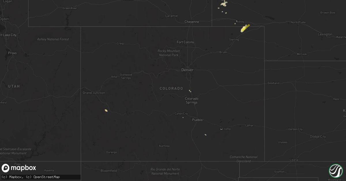
Hail Map in Colorado on July 27, 2019
Get this storm
July 27 map
$229
one time, instant access
Download today. No call, no setup
Keep the $229
Bought the map and want the full workflow? Apply the entire $229 to a subscription within 7 days. None of it is wasted.
Every map, not just this one
This buys you this map. Subscription and you get every map we run, in the markets you choose from a few cities to whole states to nationwide. Plus real-time alerts the moment a storm fires.
Contact data
Name, contact info, occupancy, even credit band for addresses in the footprint. You go from where it hit to who to call.
Become the source they trust
Unlimited branding weather history reports on demand. You already have the documented answer ready for the property owner, and you are the one who showed up with it.
Property data and RoofTrace estimates
Pull up any address you have got, its value and the exact code rules for that jurisdiction, straight from One Click Code. Then RoofTrace estimates the squares, pitch, and roof value, priced the way you price.
Storm reports in Colorado
Colorado
| Date | Description |
|---|---|
| 07/27/20192:37 AM CDT | At 737 PM MDT, a severe thunderstorm was located near Twin Buttes, or 15 miles southeast of Sidney, moving east at 25 mph. HAZARD...Golf ball size hail and 60 mph wind gusts. SOURCE...Radar indicated. IMPACT...Expect damage to roofs, siding, and trees. People and animals outdoors will be injured. Expect hail damage to roofs, siding, windows, and vehicles. Locations impacted include... Sedgwick, Crook and Twin Buttes. |
| 07/27/20192:35 AM CDT | At 735 PM MDT, a severe thunderstorm was located near Twin Buttes, or 14 miles southeast of Sidney, moving northeast at 30 mph. HAZARD...Ping pong ball size hail and 60 mph wind gusts. SOURCE...Radar indicated. IMPACT...People and animals outdoors will be injured. Expect hail damage to roofs, siding, windows, and vehicles. Expect wind damage to roofs, siding, and trees. This severe thunderstorm will be near... Lodgepole around 800 PM MDT.This includes Interstate 80 in Nebraska between mile markers 69 and77. |
| 07/27/20191:57 AM CDT | At 656 PM MDT, severe thunderstorms were located along a line extending from near Sugar City to 6 miles southwest of La Junta, moving east at 45 mph. HAZARD...60 mph wind gusts and penny size hail. SOURCE...Radar indicated. IMPACT...Expect damage to roofs, siding, and trees. Locations impacted include... La Junta, North La Junta, Rocky Ford, Las Animas, Ordway, Swink, Sugar City, Cheraw, McClave, Blue Lake, Hasty, Neegronda Reservoir, John Martin Reservoir, Sweetwater Reservoir, Caddoa and Fort Lyon. |
| 07/27/20191:04 AM CDT | At 603 PM MDT, severe thunderstorms were located along a line extending from 7 miles south of Hanover to near Blende, moving east at 45 mph. HAZARD...60 mph wind gusts. SOURCE...Radar indicated. IMPACT...Expect damage to roofs, siding, and trees. Locations impacted include... Pueblo, Olney Springs, Boone, Crowley, Blende, Avondale, Pueblo Depot, Salt Creek and Hanover. |
| 07/26/20198:07 PM CDT | A local report indicates 58 MPH wind near 4 S CHERAW |
All States Impacted by Hail Map on July 27, 2019
Cities Impacted by Hail Map on July 27, 2019
- Bradgate, IA
- Rolfe, IA
- Southwick, MA
- Iliff, CO
- Crook, CO
- Montrose, CO
- Oral, SD
- Ottosen, IA
- Rutland, IA
- Gordon, NE
- Winner, SD
- Saint Helen, MI
- Lead, SD
- Barkhamsted, CT
- Canton, CT
- Pine Ridge, SD
- West Branch, MI
- Roscommon, MI
- Houghton Lake, MI
- Tererro, NM
- Merriman, NE
- Sidney, NE
- Keystone, IA
- Model, CO
- Fowler, CO
- Newport, NE
- Livingston, MT
- Marshalltown, IA
- Spearfish, SD
- Deadwood, SD
- Palmer Lake, CO
- Monument, CO
- Harrisburg, NE
- Buffalo Gap, SD
- Edgemont, SD
- Hale, MI
- Traer, IA
- Kennebec, SD
- Crawford, NE
- Chelsea, IA
- Gladbrook, IA
- Garwin, IA
- Gering, NE
- Rocky Ford, CO
- Pentwater, MI
- Manton, MI
- Dix, NE
- Humboldt, IA
- Bode, IA
- Pecos, NM
- Saint Lawrence, SD
- Larkspur, CO
- Smithwick, SD
- Lupton, MI
- Toledo, IA
- Bassett, NE
- Avon, CT
- Livermore, IA
- Hart, MI
- Florence, CO
- Alliance, NE
- Rose City, MI
- Luzerne, IA
- Blairstown, IA
- Oglala, SD
- Lodgepole, NE
- Elmwood, WI
- Spring Valley, WI
- Tawas City, MI
- Whittemore, MI
- National City, MI
- East Tawas, MI
- Coventry, CT
- Storrs Mansfield, CT


