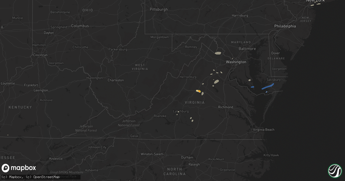
Hail Map in Virginia on July 25, 2022
Get this storm
July 25 map
$229
one time, instant access
Download today. No call, no setup
Keep the $229
Bought the map and want the full workflow? Apply the entire $229 to a subscription within 7 days. None of it is wasted.
Every map, not just this one
This buys you this map. Subscription and you get every map we run, in the markets you choose from a few cities to whole states to nationwide. Plus real-time alerts the moment a storm fires.
Contact data
Name, contact info, occupancy, even credit band for addresses in the footprint. You go from where it hit to who to call.
Become the source they trust
Unlimited branding weather history reports on demand. You already have the documented answer ready for the property owner, and you are the one who showed up with it.
Property data and RoofTrace estimates
Pull up any address you have got, its value and the exact code rules for that jurisdiction, straight from One Click Code. Then RoofTrace estimates the squares, pitch, and roof value, priced the way you price.
Storm reports in Virginia
Virginia
| Date | Description |
|---|---|
| 07/25/20225:50 PM CDT | Power outages south of lilian. Time estimated. |
| 07/25/20225:20 PM CDT | Vdot reports lane closure due to tree in roadway. |
| 07/25/20225:10 PM CDT | Vdot reports lane closure due to tree in roadway. |
| 07/25/20225:05 PM CDT | Vdot reports road closed due to several trees in road. |
| 07/25/20225:05 PM CDT | Vdot reports road closure due to downed trees blocking road. |
| 07/25/20225:04 PM CDT | Trees an |
| 07/25/20225:04 PM CDT | Trees and wires blew down in the area of rosedale drive. |
| 07/25/20224:30 PM CDT | 911 call center reports multiple trees and wires down across hanover county. Time estimated. |
| 07/25/20224:30 PM CDT | 911 call center reports wires down in multiple locations including the 1900 block of wood st in richmond. |
| 07/25/20224:05 PM CDT | Trees and wires blew down near the intersection of bethany way and va-651 kellog mill road. |
| 07/25/20223:55 PM CDT | Trees blew down near the intersection of va-655 holly corner road and holly berry road. |
| 07/25/20223:38 PM CDT | Tree damage was reported near cookstown and spotsylvania courthouse... Including along wilderness park drive. |
| 07/25/20223:28 PM CDT | Tree downed and blocking portion of ontario road. Time is radar estimated. |
| 07/25/20223:23 PM CDT | Several trees blew down along joplin rd. |
| 07/25/20223:19 PM CDT | A tree blew down near fraley blvd and possum pt rd... Blocking the roadway. |
| 07/25/20223:18 PM CDT | Trees blew down near the intersection of us-1 richmond highway/jefferson davis highway and va-619 joplin road/fuller road. |
| 07/25/20223:17 PM CDT | Trees downed onto south boston road just north of va-53. |
| 07/25/20223:10 PM CDT | Tree down. Time estimated. |
| 07/25/20223:05 PM CDT | Tree fell and brought down powerlines... Blocking eureka school road entirely. Time estimated from radar. |
| 07/25/20223:00 PM CDT | Several large tree limbs blew down around scottsville. |
| 07/25/20223:00 PM CDT | Trees downed along prince edward highway with numerous power outages reported between pamplin and elam. |
| 07/25/20222:59 PM CDT | Over half a dozen trees blown down around charlotte county... With most falling in the charlotte court house area. |
| 07/25/20222:58 PM CDT | Trees blew down near green acre drive. |
| 07/25/20222:50 PM CDT | Time radar estimated. Numerous trees downed in lake monticello with several power outages reported in the area. |
| 07/25/20222:41 PM CDT | Hail up to golf ball size was reported in pantops. |
| 07/25/20222:41 PM CDT | Dozens of trees... Wires... And large branches blew down just east of charlottesville in the pantops area. |
| 07/25/20222:40 PM CDT | Trees down in the rockfish/faber area... Including along va-6 irish road. |
| 07/25/20222:40 PM CDT | A wind gust of 58 knots |
| 07/25/20222:40 PM CDT | Wires down. Time estimated. |
| 07/25/20222:37 PM CDT | Trees and wires blew down near catlett... Including along va-604 burwell road in the 8300 block. |
| 07/25/20222:34 PM CDT | A local report indicates 1.00 inch wind near 3 E CHARLOTTESVILLE |
| 07/25/20222:34 PM CDT | Thunderstorm winds blew down one tree near the 1900 block of chalk level road. |
| 07/25/20222:32 PM CDT | Trees and large limbs blew down near reva... Including in the 2700 block of ridgeview road... Blocking the roadway. |
| 07/25/20222:32 PM CDT | Quarter size hail was reported in pantops. |
| 07/25/20222:31 PM CDT | A tree blew down near the 200 block of river rd. |
| 07/25/20222:29 PM CDT | Several trees... Wires and tree limbs blew down in and near the city of charlottesville. |
| 07/25/20222:28 PM CDT | Three trees blew down near the 16900 block of north merrimac rd. |
| 07/25/20222:28 PM CDT | Trees and large tree limbs blew down near va-719 mountain lake road and bella pointe drive. |
| 07/25/20222:15 PM CDT | Thunderstorm winds blew down multiple large tree branches near the intersection of oxford road and lark drive. |
| 07/25/20221:49 PM CDT | Thunderstorm winds blew down numerous trees along winebarger circle. |
| 07/25/20221:49 PM CDT | Several trees blown down throughout lynchburg. Time estimated from radar. |
| 07/25/20221:49 PM CDT | Several trees blown down throughout lynchburg. Time estimated from radar. (rnk |
| 07/25/20221:49 PM CDT | Tree blown down near the intersection of feldspar road and bold branch road. Time estimated from radar. |
| 07/25/20221:47 PM CDT | A tree blew down near rt. 740e and james monroe hwy |
| 07/25/20221:45 PM CDT | Several trees blew down around leesburg... Including near the intersection of us-15 james monroe highway and va-740 tutt lane. Trees blew down near the intersection of |
| 07/25/20221:45 PM CDT | Tree down along south old moneta road near downtown moneta drive. Time estimated from radar. |
| 07/25/20221:20 PM CDT | Large tree blocking all lanes on harveys creek road near intersection with stewartsville road. Time estimated from radar. |
| 07/25/20221:18 PM CDT | Couple of trees down along highway 460 in the vicinity of patterson mill road. Time estimated from radar. |
| 07/25/20221:09 PM CDT | Multiple trees and power lines down along hardy road from post office to intersection with wysong mill road at 2:13pm. |
| 07/25/20221:02 PM CDT | Tree down along highway 460 near the thaxton community center. Time estimated from radar. |
| 07/25/202212:43 PM CDT | Thunderstorm winds blew down multiple tree branches and a shed door. |
| 07/25/202212:28 PM CDT | Thunderstorm winds blew down a power line along den hill road. |
| 07/25/202212:24 PM CDT | Thunderstorm winds blew down one large tree branch that took the mirror off a car on gobblers spur. |
| 07/25/202212:23 PM CDT | Thunderstorm winds blew down one large tree branch near the intersection of industrial park road and south main street. |
| 07/25/202212:14 PM CDT | Thunderstorm winds blew down one tree near the intersection of smith avenue and todd street. |
| 07/25/20227:55 AM CDT | At 1254 PM EDT, a severe thunderstorm was located over Poplar Hill, moving east at 25 mph. HAZARD...60 mph wind gusts. SOURCE...Radar indicated. IMPACT...Expect damage to roofs, siding, and trees. Locations impacted include... Blacksburg... Christiansburg... Radford... Pulaski... Dublin... Pembroke... and Newport. |
| 07/25/20222:30 AM CDT | At 729 PM EDT, a severe thunderstorm was located over Fruitland, moving east at 35 mph. HAZARD...60 mph wind gusts. SOURCE...Radar indicated. IMPACT...Expect damage to trees and powerlines. This severe thunderstorm will be near... Parsonsburg around 740 PM EDT. Snow Hill around 750 PM EDT. Newark around 755 PM EDT. Berlin around 805 PM EDT. Ocean Pines around 810 PM EDT. Ocean City and Cape Isle Of Wight around 815 PM EDT.Other locations impacted by this severe thunderstorm include Bishop,Boxiron, Ocean City Municipality, Salisbury-Wicomico, Bishopville,Goodwill, Public Landing, Ironshire, Willards and West Ocean City. |
| 07/25/20221:56 AM CDT | At 655 PM EDT, a severe thunderstorm was located near Deal Island, or 13 miles west of Princess Anne, moving east at 40 mph. HAZARD...60 mph wind gusts. SOURCE...Radar indicated. IMPACT...Expect damage to trees and powerlines. This severe thunderstorm will be near... Princess Anne and University Of Maryland Eastern Shore around 715 PM EDT. Fruitland around 720 PM EDT. Salisbury and Salisbury University around 725 PM EDT. Parsonsburg around 735 PM EDT.Other locations impacted by this severe thunderstorm includeWetipquin, Trinity, Cokesbury, Goodwill, Eden, Kingston, Saxis,Shelltown, Longridge and Mount Vernon. |
| 07/25/202212:55 AM CDT | At 554 PM EDT, a severe thunderstorm was located over Manquin, or near King William, moving northeast at 40 mph. HAZARD...60 mph wind gusts and penny size hail. SOURCE...Radar indicated. IMPACT...Expect damage to trees and powerlines. This severe thunderstorm will be near... King William around 605 PM EDT. Saint Stephens Church and Stevensville around 610 PM EDT. Millers Tavern around 615 PM EDT. Tappahannock, Dunnsville and Center Cross around 625 PM EDT. Sharps around 635 PM EDT. Warsaw, Haynesville and Farnham around 640 PM EDT.Other locations impacted by this severe thunderstorm includeThreeway, Upright, Ino, Dragonville, Rose Garden, Tidewater, Lyells,Crouch, Palls and Kennard. |
| 07/25/202212:23 AM CDT | At 523 PM EDT, severe thunderstorms were located along a line extending from near Hanover to Downtown Richmond, moving northeast at 35 mph. HAZARD...60 mph wind gusts and quarter size hail. SOURCE...Radar indicated. IMPACT...Minor damage to vehicles is possible. Expect wind damage to trees and powerlines. Severe thunderstorms will be near... Studley around 545 PM EDT. Manquin and Tunstall around 555 PM EDT.Other locations impacted by these severe thunderstorms includeEnfield, Richmond Heights, Elko, Elmont, Montrose, Sandston,Westwood, Richmond International, Fair Oaks and Solomons Store. |
| 07/25/202212:20 AM CDT | At 519 PM EDT, severe thunderstorms were located along a line extending from Ladysmith to near Kings Dominion to Hanover, moving east at 25 mph. HAZARD...60 mph wind gusts. SOURCE...Radar indicated. IMPACT...Expect damage to trees and powerlines. Locations impacted include... Ashland, Bowling Green, Randolph Macon College, Milford, Hanover, Beulahville, Ladysmith, Dawn, Aylett, Kings Dominion, Mangohick, Fort A.p. Hill, Chilesburg, Golansville, Guinea, Corbin, Gum Tree, Etna Mills, Penola and Epworth. |
| 07/24/202211:37 PM CDT | At 437 PM EDT, a severe thunderstorm was located 11 miles northwest of Spotsylvania, or 12 miles west of Fredericksburg, moving east at 35 mph. HAZARD...70 mph wind gusts and ping pong ball size hail. SOURCE...Radar indicated. IMPACT...Damaging winds will cause some trees and large branches to fall. This could injure those outdoors, as well as damage homes and vehicles. Roadways may become blocked by downed trees. Localized power outages are possible. Unsecured light objects may become projectiles. Locations impacted include... Fredericksburg, Falmouth, Stones Corner, Leeland, Flat Run, Spring Valley, Brooke, Chancellorsville, Ramoth, Storck, Holly Corner, Dunavant, Lake Of The Woods, Glendie, Hartwood, Brookfield and Cookstown. |
| 07/24/202211:21 PM CDT | At 420 PM EDT, a severe thunderstorm was located 10 miles east of Orange, moving east at 35 mph. HAZARD...60 mph wind gusts and quarter size hail. SOURCE...Radar indicated. IMPACT...Damaging winds will cause some trees and large branches to fall. This could injure those outdoors, as well as damage homes and vehicles. Roadways may become blocked by downed trees. Localized power outages are possible. Unsecured light objects may become projectiles. Locations impacted include... Orange, Spotsylvania, Mine Run, Everona, Verdiersville, Locust Grove, Snell, Thornhill, Nasons, Glenora, Lake Of The Woods, Unionville, Cookstown, Rhoadesville, Brokenburg, Parker, Rapidan, Burr Hill, Madison Run and Alsop. |
| 07/24/202211:15 PM CDT | At 414 PM EDT, a severe thunderstorm was located near Troy, or near Palmyra, moving east at 25 mph. HAZARD...60 mph wind gusts and nickel size hail. SOURCE...Radar indicated. IMPACT...Expect damage to trees and powerlines. This severe thunderstorm will be near... Ferncliff and Kents Store around 425 PM EDT.Other locations impacted by this severe thunderstorm include Nahor,Louisa Airport, Stage Junction, Zion Crossroads, Union Mills,Caledonia, Wildwood, Bybee, Yanceyville and Waldrop. |
| 07/24/202210:58 PM CDT | At 358 PM EDT, a severe thunderstorm was located over Hampden Sydney College, moving east at 40 mph. HAZARD...60 mph wind gusts and quarter size hail. SOURCE...Radar indicated. IMPACT...Minor damage to vehicles is possible. Expect wind damage to trees and powerlines. This severe thunderstorm will be near... Farmville, Longwood University and Green Bay around 405 PM EDT. Burkeville and Rice around 415 PM EDT. Crewe around 420 PM EDT. Jetersville around 430 PM EDT. Morven around 435 PM EDT. Amelia Courthouse around 440 PM EDT. Chula around 445 PM EDT.Other locations impacted by this severe thunderstorm include RainesTavern, North Wellville, Tuggle, Irby, Prince Edward Station, Angola,Briery, Arvins Store, Murdocks and Twin Lakes State Park. |
| 07/24/202210:37 PM CDT | At 337 PM EDT, a severe thunderstorm was located near Charlottesville, moving east at 25 mph. HAZARD...70 mph wind gusts and quarter size hail. SOURCE...Radar indicated. IMPACT...Minor damage to vehicles is possible. Expect considerable tree damage. Wind damage is also likely to mobile homes, roofs, and outbuildings. This severe thunderstorm will be near... Lake Monticello around 345 PM EDT. Troy around 355 PM EDT. Boswells Tavern around 400 PM EDT. Ferncliff around 410 PM EDT. Louisa around 415 PM EDT.Other locations impacted by this severe thunderstorm include Nahor,Green Springs, Zion Crossroads, Union Mills, Wildwood, Bybee,Waldrop, Byrd Mill, Trevilians and Wilmington. |
| 07/24/202210:34 PM CDT | At 333 PM EDT, a severe thunderstorm was located near Culpeper, moving east at 30 mph. HAZARD...60 mph wind gusts and quarter size hail. SOURCE...Radar indicated. IMPACT...Damaging winds will cause some trees and large branches to fall. This could injure those outdoors, as well as damage homes and vehicles. Roadways may become blocked by downed trees. Localized power outages are possible. Unsecured light objects may become projectiles. Locations impacted include... Culpeper, Catalpa, Elkwood, Cardova, Brandy Station, Rixeyville and Alanthus. |
| 07/24/202210:31 PM CDT | At 331 PM EDT, a severe thunderstorm was located near Red House, moving east at 25 mph. HAZARD...60 mph wind gusts and quarter size hail. SOURCE...Radar indicated. IMPACT...Hail damage to vehicles is expected. Expect wind damage to roofs, siding, and trees. Locations impacted include... Brookneal... Charlotte Court House... Phenix... Red House... Drakes Branch... Pamplin City... and Madisonville. |
| 07/24/202210:31 PM CDT | At 331 PM EDT, a severe thunderstorm was located over Bealeton, or 9 miles south of Warrenton, moving southeast at 30 mph. HAZARD...60 mph wind gusts and quarter size hail. SOURCE...Radar indicated. IMPACT...Damaging winds will cause some trees and large branches to fall. This could injure those outdoors, as well as damage homes and vehicles. Roadways may become blocked by downed trees. Localized power outages are possible. Unsecured light objects may become projectiles. Locations impacted include... Bealeton, Opal, Remington, Midland, Lois, Heflin, Storck, Morrisville, Ruby, Somerville, Goldvein, Sumerduck and Bristersburg. |
| 07/24/202210:27 PM CDT | At 327 PM EDT, a severe thunderstorm was located over Charlottesville, moving east at 20 mph. HAZARD...60 mph wind gusts and quarter size hail. SOURCE...Radar indicated. IMPACT...Damaging winds will cause some trees and large branches to fall. This could injure those outdoors, as well as damage homes and vehicles. Roadways may become blocked by downed trees. Localized power outages are possible. Unsecured light objects may become projectiles. Locations impacted include... Charlottesville, Campbell, Westmoreland, Cobham, Cismont, Newcomb Hall, Boyd Tavern, Monticello, Keswick, Carrsbrook, Shadwell, Barracks and Scott Stadium. |
| 07/24/202210:26 PM CDT | At 326 PM EDT, a severe thunderstorm was located 7 miles northeast of Madison, moving east at 25 mph. HAZARD...60 mph wind gusts and quarter size hail. SOURCE...Radar indicated. IMPACT...Damaging winds will cause some trees and large branches to fall. This could injure those outdoors, as well as damage homes and vehicles. Roadways may become blocked by downed trees. Localized power outages are possible. Unsecured light objects may become projectiles. Locations impacted include... Culpeper, Brightwood, Raccoon Ford, Winston, Stevensburg, Mitchells, Fordsville and Leon. |
| 07/24/202210:22 PM CDT | At 322 PM EDT, a severe thunderstorm was located near Madisonville, or near Red House, moving northeast at 20 mph. HAZARD...60 mph wind gusts and quarter size hail. SOURCE...Radar indicated. IMPACT...Minor damage to vehicles is possible. Expect wind damage to trees and powerlines. This severe thunderstorm will be near... Darlington Heights around 340 PM EDT. Prospect around 355 PM EDT. Farmville, Hampden Sydney, Hampden Sydney College and Longwood University around 400 PM EDT.Other locations impacted by this severe thunderstorm include RainesTavern, Briery Creek Lake, Tuggle, Prince Edward Station, Briery,Twin Lakes State Park, Allens Mill, Kingsville, Elam and Reeds. |
| 07/24/202210:09 PM CDT | At 309 PM EDT, a severe thunderstorm was located near Lowesville, or 7 miles north of Clifford, moving east at 20 mph. HAZARD...60 mph wind gusts. SOURCE...Radar indicated. IMPACT...Damaging winds will cause some trees and large branches to fall. This could injure those outdoors, as well as damage homes and vehicles. Roadways may become blocked by downed trees. Localized power outages are possible. Unsecured light objects may become projectiles. Locations impacted include... Shipman, Arrington, Lovingston, Bryant, Jonesboro, Roseland, Elma, Tyro and Massies Mill. |
| 07/24/202210:09 PM CDT | At 308 PM EDT, severe thunderstorms were located along a line extending from near Leesville to near Gretna to near Pittsville, moving east at 30 mph. HAZARD...60 mph wind gusts and quarter size hail. SOURCE...Radar indicated. IMPACT...Hail damage to vehicles is expected. Expect wind damage to roofs, siding, and trees. Locations impacted include... Halifax... Hurt... Gretna... Brookneal... Ingram... Mt Airy... and Nathalie. |
| 07/24/202210:02 PM CDT | At 302 PM EDT, a severe thunderstorm was located near Warrenton, moving east at 30 mph. HAZARD...60 mph wind gusts and quarter size hail. SOURCE...Radar indicated. IMPACT...Damaging winds will cause some trees and large branches to fall. This could injure those outdoors, as well as damage homes and vehicles. Roadways may become blocked by downed trees. Localized power outages are possible. Unsecured light objects may become projectiles. Locations impacted include... Warrenton, Linton Hall, Bull Run, Manassas, Sudley, Gainesville, New Baltimore, Nokesville, Opal, Catlett, Calverton, Midland, Broken Hill, Auburn, Casanova, Jeffersonton, Greenwich, Turnbull, Aden and Airlie. |
| 07/24/20229:46 PM CDT | At 246 PM EDT, a severe thunderstorm was located near Charlottesville, moving east at 20 mph. HAZARD...60 mph wind gusts and quarter size hail. SOURCE...Radar indicated. IMPACT...Damaging winds will cause some trees and large branches to fall. This could injure those outdoors, as well as damage homes and vehicles. Roadways may become blocked by downed trees. Localized power outages are possible. Unsecured light objects may become projectiles. Locations impacted include... Charlottesville, Campbell, Westmoreland, Hollymead, Ivy, Cobham, Cismont, Newcomb Hall, Monticello, Keswick, Stony Point, Flordon, Carrsbrook, Shadwell, Barracks, Scott Stadium and Boyd Tavern. |
| 07/24/20229:43 PM CDT | At 242 PM EDT, severe thunderstorms were located along a line extending from near Madison Heights to Bocock to near Evington, moving northeast at 40 mph. HAZARD...60 mph wind gusts and quarter size hail. SOURCE...Radar indicated. IMPACT...Hail damage to vehicles is expected. Expect wind damage to roofs, siding, and trees. Locations impacted include... Lynchburg... Amherst... Appomattox... Bent Creek... Concord... Rustburg... and Forest. |
| 07/24/20229:26 PM CDT | At 226 PM EDT, severe thunderstorms were located along a line extending from Northwest Smith Mountain Lake to near Western Smith Mountain Lake to near Rocky Mount, moving east at 20 mph. HAZARD...60 mph wind gusts and quarter size hail. SOURCE...Radar indicated. IMPACT...Hail damage to vehicles is expected. Expect wind damage to roofs, siding, and trees. Locations impacted include... Rocky Mount... Huddleston... Moneta... Penhook... Burnt Chimney... Northwest Smith Mountain Lake... and Goodview. |
| 07/24/20229:13 PM CDT | At 213 PM EDT, a severe thunderstorm was located near Thaxton, or near Moneta, moving east at 15 mph. HAZARD...60 mph wind gusts. SOURCE...Radar indicated. IMPACT...Expect damage to roofs, siding, and trees. Locations impacted include... Bedford... Altavista... Hurt... Huddleston... Forest... Evington... and Goode. |
| 07/24/20228:41 PM CDT | At 139 PM EDT, a severe thunderstorm was located over Crockett Springs, or near Shawsville, moving east at 35 mph. This storm has a history of creating wind gusts in excess of 45 mph. HAZARD...60 mph wind gusts. SOURCE...Radar indicated. IMPACT...Expect damage to roofs, siding, and trees. Locations impacted include... Roanoke... Salem... Christiansburg... Vinton... Rocky Mount... Boones Mill... and Pilot. |
All States Impacted by Hail Map on July 25, 2022
Cities Impacted by Hail Map on July 25, 2022
- Kimball, NE
- Bushnell, NE
- Bethesda, MD
- Catlett, VA
- Inglis, FL
- Willow City, ND
- Rugby, ND
- Guthrie, KY
- Allensville, KY
- Locust Grove, VA
- Spotsylvania, VA
- Unionville, VA
- Rhoadesville, VA
- New Athens, IL
- Freeburg, IL
- Mascoutah, IL
- Crookston, NE
- Portland, TN
- Tremont, MS
- Land O'Lakes, FL
- Charlottesville, VA
- Valentine, NE
- East Saint Louis, IL
- Elmont, NY
- Floral Park, NY
- Franklin Square, NY
- West Hempstead, NY
- Garden City, NY
- New Hyde Park, NY
- Savage, MT
- Kilgore, NE
- Kim, CO
- Far Rockaway, NY
- Brooklyn, NY
- Hayes, SD
- Fort Pierre, SD
- East Hanover, NJ
- Livingston, NJ
- Whippany, NJ
- Roseland, NJ
- Colorado Springs, CO
- Ravenden Springs, AR
- Ravenden, AR
- Hardy, AR
- Salt Flat, TX
- Dunnellon, FL
- Crystal River, FL
- Appomattox, VA
- Red House, VA
- Midland, VA
- Bealeton, VA
- McEwen, TN
- Tompkinsville, KY
- Charlotte Court House, VA
- Cullen, VA
- Roslyn Heights, NY
- Roslyn, NY
- Manhasset, NY
- Old Westbury, NY
- Albertson, NY
- Barboursville, VA
- Oldsmar, FL
- Tampa, FL
- Murdo, SD
- Draper, SD
- Las Animas, CO
- Franklin, KY
- Lynchburg, VA
- Evington, VA
- Forest, VA
- Selma, AL
- Dickson, TN
- Orange, VA
- Mineral, VA
- Adairville, KY
- Springfield, TN
- Harrison, NJ
- Kearny, NJ
- Secaucus, NJ
- Jersey City, NJ
- Newark, NJ
- Dickinson, ND
- Belfield, ND
- Palmyra, VA
- Troy, VA
- Keswick, VA
- Great Neck, NY
- Chiefland, FL
- Trenton, FL
- Rienzi, MS
- California, MD
- Hollywood, MD
- Whitman, NE
- Culpeper, VA
- Jeffersonton, VA
- Warrenton, VA
- Olmstead, KY
- Rye, NH
- Kittery Point, ME
- Portsmouth, NH
- New Castle, NH
- Lobelville, TN
- Waverly, TN
- Hurricane Mills, TN
- Parrish, FL
- Cedar Hill, TN
- Dupo, IL
- Saint Louis, MO
- Millstadt, IL
- East Carondelet, IL
- Wood Lake, NE
- Merriman, NE
- Cody, NE
- Bluemont, VA
- Paeonian Springs, VA
- Hamilton, VA
- Purcellville, VA
- Harpers Ferry, WV
- Waterford, VA
- Round Hill, VA
- Roseglen, ND
- Glen Head, NY
- Little Neck, NY
- Jericho, NY
- Primm Springs, TN
- Franklin, TN
- Clarksville, TN
- Centerville, TN
- Santa Fe, TN
- Columbia, TN
- Hudson, FL
- Nantucket, MA
- Syosset, NY
- Bethpage, TN
- Willow Beach, AZ
- Cedar Key, FL
- Cottontown, TN
- Hicksville, NY
- Long Island City, NY
- Westbury, NY
- Woodbury, NY
- Plainview, NY
- Whitestone, NY
- East Elmhurst, NY
- Oakland Gardens, NY
- New York, NY
- Sunnyside, NY
- Greenvale, NY
- Flushing, NY
- College Point, NY
- Williston Park, NY
- Woodside, NY
- Corona, NY
- Bayside, NY
- Astoria, NY
- Jackson Heights, NY
- Bedford, NH
- Auburn, NH
- Manchester, NH
- Staten Island, NY
- Martin, SD
- Tuthill, SD
- Northport, NY
- Carrizozo, NM
- Madison, NH
- Saint Inigoes, MD
- Ridge, MD
- Dameron, MD
- Eden, MD
- Princess Anne, MD
- Deal Island, MD
- Westover, MD
- Crisfield, MD
- Huntington Station, NY
- Huntington, NY
- Melville, NY
- Branson, CO
- Richardton, ND
- Gladstone, ND
- Taylor, ND


