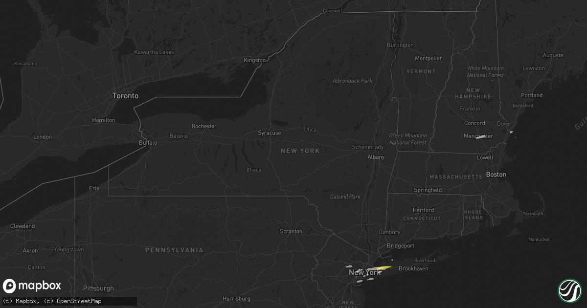
Hail Map in New York on July 25, 2022
Get this storm
July 25 map
$229
one time, instant access
Download today. No call, no setup
Keep the $229
Bought the map and want the full workflow? Apply the entire $229 to a subscription within 7 days. None of it is wasted.
Every map, not just this one
This buys you this map. Subscription and you get every map we run, in the markets you choose from a few cities to whole states to nationwide. Plus real-time alerts the moment a storm fires.
Contact data
Name, contact info, occupancy, even credit band for addresses in the footprint. You go from where it hit to who to call.
Become the source they trust
Unlimited branding weather history reports on demand. You already have the documented answer ready for the property owner, and you are the one who showed up with it.
Property data and RoofTrace estimates
Pull up any address you have got, its value and the exact code rules for that jurisdiction, straight from One Click Code. Then RoofTrace estimates the squares, pitch, and roof value, priced the way you price.
Storm reports in New York
New York
| Date | Description |
|---|---|
| 07/25/202212:45 PM CDT | A local report indicates 1.00 inch wind near 1 SE SYOSSET |
| 07/25/202212:40 PM CDT | Spotter reports 1 inch hail in roslyn heights. |
| 07/25/20227:43 AM CDT | At 1243 AM EDT, a severe thunderstorm was located over Corry, moving east at 45 mph. HAZARD...60 mph wind gusts. SOURCE...Radar indicated. IMPACT...Expect damage to roofs, siding, and trees. Locations impacted include... Warren, Columbus, Youngsville, Russell, Spring Creek, Scandia, Lottsville, Grand Valley, Enterprise, Warren South, Garland and Kinzua Dam. |
| 07/25/20227:31 AM CDT | At 1231 AM EDT, severe thunderstorms were located along a line extending from 6 miles west of Ashford Hollow to Columbus, moving east at 55 mph. HAZARD...60 mph wind gusts. SOURCE...Radar indicated. IMPACT...Expect damage to trees and power lines. Locations impacted include... Jamestown, Olean, Salamanca, Wellsville, Allegany State Park, Alfred, Lakewood, Falconer, Ashford and Allegany.This includes Interstate 86 between exits 11 and 33. |
| 07/25/20227:25 AM CDT | At 1225 PM EDT, a severe thunderstorm was located over East Hanover, or near Caldwell, moving east at 35 mph. HAZARD...60 mph wind gusts and penny size hail. SOURCE...Radar indicated. IMPACT...Expect damage to trees and power lines. This severe thunderstorm will be near... Orange and Caldwell around 1230 PM EDT. Newark around 1235 PM EDT. Paterson and Bloomfield around 1240 PM EDT. Passaic and Lyndhurst around 1245 PM EDT. Hoboken and Hackensack around 1250 PM EDT. Bergenfield and Ridgefield around 1255 PM EDT. Mott Haven and RFK Bridge around 100 PM EDT. East Tremont and Laguardia Airport around 105 PM EDT. |
| 07/25/20227:17 AM CDT | At 1217 AM EDT, a severe thunderstorm was located over West Seneca, moving northeast at 55 mph. HAZARD...60 mph wind gusts. SOURCE...Radar indicated. IMPACT...Expect damage to trees and power lines. Locations impacted include... Buffalo, Cheektowaga, West Seneca, Clarence, Lackawanna, Batavia, Kenmore, Depew, Tonawanda and Amherst.This includes Interstate 90 between exits 57A and 48. |
| 07/25/20227:12 AM CDT | At 1212 AM EDT, a severe thunderstorm was located near Cambridge Springs, or 10 miles north of Meadville, moving east at 40 mph. HAZARD...60 mph wind gusts. SOURCE...Radar indicated. IMPACT...Expect damage to trees and power lines. Locations impacted include... Corry, Edinboro, Union City, Cambridge Springs, Riceville, Lincolnville, Canadohta Lake, Saegertown, Hydetown, Mill Village, Blooming Valley, Townville, Spartansburg, Venango, Elgin and Woodcock. |
| 07/25/202212:15 AM CDT | Large tree limbs down and blocking old field road. |
| 07/25/202212:14 AM CDT | Weather station recorded a 64 mph gust. |
| 07/24/202211:25 PM CDT | At 425 PM EDT, a severe thunderstorm was located over Parksville, or near Liberty, moving east at 30 mph. HAZARD...60 mph wind gusts. SOURCE...Radar indicated. IMPACT...Expect damage to roofs, siding, and trees. Locations impacted include... Fallsburg, Liberty, Neversink, South Fallsburg, Woodridge, White Sulphur Springs, Parksville, Loch Sheldrake, Woodbourne and Livingston Manor. |
| 07/24/20229:01 PM CDT | At 200 AM EDT, severe thunderstorms were located along a line extending from near Rutland Center to near Pulaski, moving east at 55 mph. HAZARD...60 mph wind gusts. SOURCE...Radar indicated. IMPACT...Expect damage to trees and power lines. Locations impacted include... Watertown, Fort Drum, Carthage, Lowville, Pulaski, West Carthage, Adams, Herrings, Adams Center and Barnes Corners.This includes Interstate 81 between exits 35 and 47. |
| 07/24/20228:53 PM CDT | At 153 AM EDT, a severe thunderstorm was located over Greenwood, or 14 miles south of Hornell, moving east at 45 mph. HAZARD...60 mph wind gusts and nickel size hail. SOURCE...Radar indicated. IMPACT...Expect damage to roofs, siding, and trees. Locations impacted include... Elmira, Corning, Southport, Big Flats, Horseheads, Elmira Heights, Campbell, Caton, Lindley and Painted Post. |
| 07/24/20228:29 PM CDT | At 128 PM EDT, a severe thunderstorm was located over Manhasset, or over Great Neck, moving east at 30 mph. HAZARD...60 mph wind gusts and quarter size hail. SOURCE...Radar indicated. IMPACT...Minor hail damage to vehicles is possible. Expect wind damage to trees and power lines. This severe thunderstorm will be near... Glen Cove and Hempstead around 135 PM EDT. Westbury around 140 PM EDT. Levittown and Hicksville around 145 PM EDT. Syosset and Oyster Bay around 150 PM EDT. Plainview and Farmingdale around 155 PM EDT. Huntington Station and Huntington around 200 PM EDT. Centerport around 205 PM EDT. |
| 07/24/20228:26 PM CDT | At 125 AM EDT, a severe thunderstorm was located over Allegany State Park, moving east at 30 mph. HAZARD...60 mph wind gusts. SOURCE...Radar indicated. IMPACT...Expect damage to trees and power lines. Locations impacted include... Olean, Salamanca, Wellsville, Allegany State Park, Alfred, Allegany, Cuba, St. Bonaventure, Whitesville and Weston Mills.This includes Interstate 86 between exits 15 and 30. |
| 07/24/20228:17 PM CDT | At 116 AM EDT, a severe thunderstorm was located 7 miles southwest of Redfield, or 12 miles northwest of Camden, moving east at 55 mph. HAZARD...60 mph wind gusts. SOURCE...Radar indicated. IMPACT...Expect damage to trees and power lines. Locations impacted include... Lowville, Redfield, Highmarket, Whetstone Gulf State Park, New Bremen, Watson, Martinsburg, Williamstown, Lyonsdale and Greig. |
All States Impacted by Hail Map on July 25, 2022
Cities Impacted by Hail Map on July 25, 2022
- Kimball, NE
- Bushnell, NE
- Bethesda, MD
- Catlett, VA
- Inglis, FL
- Willow City, ND
- Rugby, ND
- Guthrie, KY
- Allensville, KY
- Locust Grove, VA
- Spotsylvania, VA
- Unionville, VA
- Rhoadesville, VA
- New Athens, IL
- Freeburg, IL
- Mascoutah, IL
- Crookston, NE
- Portland, TN
- Tremont, MS
- Land O'Lakes, FL
- Charlottesville, VA
- Valentine, NE
- East Saint Louis, IL
- Elmont, NY
- Floral Park, NY
- Franklin Square, NY
- West Hempstead, NY
- Garden City, NY
- New Hyde Park, NY
- Savage, MT
- Kilgore, NE
- Kim, CO
- Far Rockaway, NY
- Brooklyn, NY
- Hayes, SD
- Fort Pierre, SD
- East Hanover, NJ
- Livingston, NJ
- Whippany, NJ
- Roseland, NJ
- Colorado Springs, CO
- Ravenden Springs, AR
- Ravenden, AR
- Hardy, AR
- Salt Flat, TX
- Dunnellon, FL
- Crystal River, FL
- Appomattox, VA
- Red House, VA
- Midland, VA
- Bealeton, VA
- McEwen, TN
- Tompkinsville, KY
- Charlotte Court House, VA
- Cullen, VA
- Roslyn Heights, NY
- Roslyn, NY
- Manhasset, NY
- Old Westbury, NY
- Albertson, NY
- Barboursville, VA
- Oldsmar, FL
- Tampa, FL
- Murdo, SD
- Draper, SD
- Las Animas, CO
- Franklin, KY
- Lynchburg, VA
- Evington, VA
- Forest, VA
- Selma, AL
- Dickson, TN
- Orange, VA
- Mineral, VA
- Adairville, KY
- Springfield, TN
- Harrison, NJ
- Kearny, NJ
- Secaucus, NJ
- Jersey City, NJ
- Newark, NJ
- Dickinson, ND
- Belfield, ND
- Palmyra, VA
- Troy, VA
- Keswick, VA
- Great Neck, NY
- Chiefland, FL
- Trenton, FL
- Rienzi, MS
- California, MD
- Hollywood, MD
- Whitman, NE
- Culpeper, VA
- Jeffersonton, VA
- Warrenton, VA
- Olmstead, KY
- Rye, NH
- Kittery Point, ME
- Portsmouth, NH
- New Castle, NH
- Lobelville, TN
- Waverly, TN
- Hurricane Mills, TN
- Parrish, FL
- Cedar Hill, TN
- Dupo, IL
- Saint Louis, MO
- Millstadt, IL
- East Carondelet, IL
- Wood Lake, NE
- Merriman, NE
- Cody, NE
- Bluemont, VA
- Paeonian Springs, VA
- Hamilton, VA
- Purcellville, VA
- Harpers Ferry, WV
- Waterford, VA
- Round Hill, VA
- Roseglen, ND
- Glen Head, NY
- Little Neck, NY
- Jericho, NY
- Primm Springs, TN
- Franklin, TN
- Clarksville, TN
- Centerville, TN
- Santa Fe, TN
- Columbia, TN
- Hudson, FL
- Nantucket, MA
- Syosset, NY
- Bethpage, TN
- Willow Beach, AZ
- Cedar Key, FL
- Cottontown, TN
- Hicksville, NY
- Long Island City, NY
- Westbury, NY
- Woodbury, NY
- Plainview, NY
- Whitestone, NY
- East Elmhurst, NY
- Oakland Gardens, NY
- New York, NY
- Sunnyside, NY
- Greenvale, NY
- Flushing, NY
- College Point, NY
- Williston Park, NY
- Woodside, NY
- Corona, NY
- Bayside, NY
- Astoria, NY
- Jackson Heights, NY
- Bedford, NH
- Auburn, NH
- Manchester, NH
- Staten Island, NY
- Martin, SD
- Tuthill, SD
- Northport, NY
- Carrizozo, NM
- Madison, NH
- Saint Inigoes, MD
- Ridge, MD
- Dameron, MD
- Eden, MD
- Princess Anne, MD
- Deal Island, MD
- Westover, MD
- Crisfield, MD
- Huntington Station, NY
- Huntington, NY
- Melville, NY
- Branson, CO
- Richardton, ND
- Gladstone, ND
- Taylor, ND


