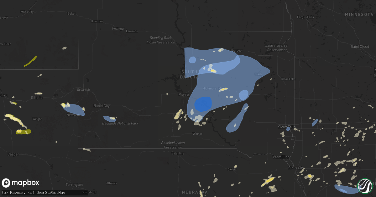
Hail Map in South Dakota on July 23, 2025
Get this storm
July 23 map
$229
one time, instant access
Download today. No call, no setup
Keep the $229
Bought the map and want the full workflow? Apply the entire $229 to a subscription within 7 days. None of it is wasted.
Every map, not just this one
This buys you this map. Subscription and you get every map we run, in the markets you choose from a few cities to whole states to nationwide. Plus real-time alerts the moment a storm fires.
Contact data
Name, contact info, occupancy, even credit band for addresses in the footprint. You go from where it hit to who to call.
Become the source they trust
Unlimited branding weather history reports on demand. You already have the documented answer ready for the property owner, and you are the one who showed up with it.
Property data and RoofTrace estimates
Pull up any address you have got, its value and the exact code rules for that jurisdiction, straight from One Click Code. Then RoofTrace estimates the squares, pitch, and roof value, priced the way you price.
Storm reports in South Dakota
South Dakota
| Date | Description |
|---|---|
| 07/23/20256:45 PM CDT | A local report indicates 63 MPH wind near 10 W Edgemont |
| 07/23/20256:40 PM CDT | Several large tree limbs down up to 6 inches in diameter. |
| 07/23/20256:37 PM CDT | Measured by personal weather station. |
| 07/23/20256:35 PM CDT | A local report indicates 65 MPH wind near 10 W Edgemont |
| 07/23/20256:25 PM CDT | A local report indicates 59 MPH wind near 14 NNW Edgemont |
| 07/23/202510:14 AM CDT | Personal weather station. |
| 07/23/20259:50 AM CDT | Cattle pod and grain bin damage. |
| 07/23/20259:50 AM CDT | Door torn off machine shed and other sheet metal damage to building. |
| 07/23/20259:33 AM CDT | Roof blown off post frame building. Time estimated from radar. |
| 07/23/20259:28 AM CDT | Roof blown off of a metal shed along the south shore of lake byron. Time estimated by radar. |
| 07/23/20259:26 AM CDT | Boat capsized on dry lake due to strong winds. |
| 07/23/20259:23 AM CDT | Mesonet station 284 spink colony 9 sse jct sd28/sd37 |
| 07/23/20259:21 AM CDT | 71 mph gust recorded at a personal weather station. |
| 07/23/20259:20 AM CDT | Images of trees broken at the trunk sent via social media. Time estimated based on radar and other nearby damage reports. |
| 07/23/20259:18 AM CDT | About 20 trees downed at golf course. Time estimated based on khon asos observation. |
| 07/23/20259:15 AM CDT | Large tree down in huron near the intersection of 7th st. And dakota ave. |
| 07/23/20259:13 AM CDT | Mesonet station 215 polo 17 w jct sd47/sd26 |
| 07/23/20259:11 AM CDT | Asos station khon huron regional airport. Gusted again to 82 mph at 9:18 am. |
| 07/23/20259:11 AM CDT | 64 mph gust recorded at a personal weather station. |
| 07/23/20259:06 AM CDT | Mesonet station 164 sd rwis wolsey. |
| 07/23/20259:03 AM CDT | Mesonet station 164 sd rwis wolsey. |
| 07/23/20259:03 AM CDT | Asos station khon huron regional airport. |
| 07/23/20259:00 AM CDT | Roof blown off outbuilding. Time estimated from radar. |
| 07/23/20258:48 AM CDT | Mesonet station 312 ree heights |
| 07/23/20258:30 AM CDT | Mesonet station 173 craven |
| 07/23/20258:25 AM CDT | Mesonet station 173 craven |
| 07/23/20258:25 AM CDT | Mesonet station 4 sse canning sdsu site. |
| 07/23/20258:13 AM CDT | Mesonet station 315 cresbard |
| 07/23/20258:12 AM CDT | Mesonet station 289 lees corner |
| 07/23/20258:05 AM CDT | Mesonet station lbms2 lower brule 2wnw |
| 07/23/20258:00 AM CDT | Spotter also reports 1 inch of rain in 15 minutes. |
| 07/23/20258:00 AM CDT | Mesonet station lbms2 lower brule 2wnw |
| 07/23/20257:45 AM CDT | Mesonet station hmms2 highmore 23n |
| 07/23/20257:40 AM CDT | Mesonet station kbms2 kennebec 6sse |
| 07/23/20257:23 AM CDT | Via personal weather station. |
| 07/23/20257:17 AM CDT | Several 3-4 inch diameter tree branches down in town. |
| 07/23/20257:15 AM CDT | A local report indicates 70 MPH wind near 3 SE Plankinton |
| 07/23/20257:10 AM CDT | Mesonet station lrms2 lowry 2s |
| 07/22/20257:31 PM CDT | A local report indicates 64 MPH wind near 8 SSW Folsom |
| 07/22/20257:26 PM CDT | A local report indicates 64 MPH wind near 8 SSW Folsom |
| 07/22/20257:25 PM CDT | A local report indicates 66 MPH wind near 7 SSW Folsom |
All States Impacted by Hail Map on July 23, 2025
Cities Impacted by Hail Map on July 23, 2025
- Stickney, SD
- Plankinton, SD
- Hamill, SD
- Ideal, SD
- Laporte, MN
- Akeley, MN
- Deer River, MN
- Wood, SD
- Presho, SD
- Gregory, SD
- White River, SD
- Bena, MN
- Kennebec, SD
- Walker, MN
- Hoven, SD
- Hardin, MT
- Selby, SD
- Gettysburg, SD
- Java, SD
- Agar, SD
- Glenham, SD
- Akaska, SD
- Eagle Butte, SD
- Bowdle, SD
- Onaka, SD
- Seneca, SD
- Onida, SD
- Tolstoy, SD
- Lebanon, SD
- Roscoe, SD
- Faulkton, SD
- Corsica, SD
- Platte, SD
- Kimball, SD
- Harrison, SD
- White Lake, SD
- Mount Vernon, SD
- Letcher, SD
- Miller, SD
- Murdo, SD
- Reliance, SD
- Vivian, SD
- Ipswich, SD
- Orient, SD
- Cresbard, SD
- Fort Thompson, SD
- Hayes, SD
- Fort Pierre, SD
- Draper, SD
- Bovey, MN
- Gann Valley, SD
- Saint Lawrence, SD
- Woonsocket, SD
- Chamberlain, SD
- Lower Brule, SD
- Wessington, SD
- Artesian, SD
- Cohasset, MN
- Mansfield, SD
- Northville, SD
- Rockham, SD
- Ashton, SD
- Pierre, SD
- Ree Heights, SD
- Stephan, SD
- Blunt, SD
- Holabird, SD
- Harrold, SD
- Highmore, SD
- Grand Rapids, MN
- Wessington Springs, SD
- Willow Lake, SD
- Virgil, SD
- Aberdeen, SD
- Warner, SD
- Mellette, SD
- Redfield, SD
- Bryant, SD
- Hayti, SD
- Hazel, SD
- Hitchcock, SD
- Wolsey, SD
- Huron, SD
- Cavour, SD
- Alpena, SD
- Otter, MT
- Tulare, SD
- Yale, SD
- Carpenter, SD
- Iroquois, SD
- Doland, SD
- Frankfort, SD
- Raymond, SD
- Clark, SD
- Turton, SD
- Garden City, SD
- Conde, SD
- Brentford, SD
- Henry, SD
- Vienna, SD
- Stratford, SD
- Bradley, SD
- Andover, SD
- Groton, SD
- Webster, SD
- Bristol, SD
- Florence, SD
- Wallace, SD
- Siren, WI
- Fairhope, AL
- Kaycee, WY
- Lewellen, NE
- Ryegate, MT
- Iuka, MS
- Ogallala, NE
- Buffalo, WY
- Eleva, WI
- Lemoyne, NE
- Mondovi, WI
- Strum, WI
- Osseo, WI
- Venango, NE
- Kinmundy, IL
- Marion, IL
- Paxton, NE
- Keystone, NE
- Creal Springs, IL
- Grant, NE
- Lavina, MT
- Stanley, WI
- Madrid, NE
- Elsie, NE
- Greenwood, WI
- Broadview, MT
- Gillette, WY
- Alma, WI
- Iuka, IL
- McCook, NE
- North Platte, NE
- Hershey, NE
- Wallace, NE
- Owen, WI
- Midwest, WY
- Independence, WI
- Whitehall, WI
- Burwell, NE
- Fort Collins, CO
- Acton, MT
- Merna, NE
- Callaway, NE
- Brady, NE
- Culbertson, NE
- Herndon, KS
- Imperial, NE
- Ringle, WI
- Schofield, WI
- Sutherland, NE
- Glenrock, WY
- Lebanon, NE
- Indianola, NE
- Wheatland, WY
- Chambers, NE
- Sargent, NE
- Dickens, NE
- Birnamwood, WI
- Hatley, WI
- Biloxi, MS
- Ault, CO
- Wellfleet, NE
- Maywood, NE
- Comstock, NE
- Mattoon, WI
- McDonald, KS
- Altura, MN
- Ashland, KS
- Aniwa, WI
- Bartley, NE
- Moorefield, NE
- Danbury, NE
- Antigo, WI
- Mosinee, WI
- Maxwell, NE
- Upton, WY
- Booker, TX
- Broken Bow, NE
- Curtis, NE
- Rosholt, WI
- Bowler, WI
- Wittenberg, WI
- Neopit, WI
- Tigerton, WI
- Osage, WY
- Atwood, KS
- Gothenburg, NE
- Ewing, NE
- Gresham, WI
- Hanlontown, IA
- Kensett, IA
- Fertile, IA
- Brewster, NE
- Keshena, WI
- Broadus, MT
- Billings, MT
- Douglas, WY
- Ansley, NE
- Westerville, NE
- Iola, WI
- Ventura, IA
- Garner, IA
- Oberlin, KS
- Cambridge, NE
- Newcastle, WY
- Arapahoe, NE
- Sundance, WY
- Moorcroft, WY
- Hill City, SD
- Westbrook, TX
- Bassett, NE
- Suring, WI
- Stockville, NE
- Gillett, WI
- Pound, WI
- Farnam, NE
- Marion, WI
- Boaz, KY
- Hickory, KY
- Cheyenne, WY
- Pampa, TX
- Miami, TX
- Canadian, TX
- Mobeetie, TX
- Perryton, TX
- Custer, SD
- Anselmo, NE
- Saint Charles, MN
- Eustis, NE
- Lance Creek, WY
- Forest City, IA
- Cozad, NE
- Dannebrog, NE
- Taylor, NE
- Clintonville, WI
- Shiocton, WI
- Bear Creek, WI
- Lena, WI
- Oconto Falls, WI
- Oconto, WI
- New London, WI
- Manawa, WI
- Ogdensburg, WI
- Black Creek, WI
- Appleton, WI
- Nichols, WI
- Kaukauna, WI
- Seymour, WI
- Cecil, WI
- Shawano, WI
- Abrams, WI
- Peshtigo, WI
- Elwood, NE
- Oconto, NE
- Fountain, MN
- Chatfield, MN
- Mason City, NE
- Oneill, NE
- Saint Paul, NE
- Coleman, WI
- Lexington, NE
- Lake Mills, IA
- Leland, IA
- Spring Valley, MN
- Clear Lake, IA
- Oneida, WI
- Green Bay, WI
- De Pere, WI
- Bonduel, WI
- Marinette, WI
- Denmark, WI
- Wrightstown, WI
- Greenleaf, WI
- Colorado City, TX
- Norcatur, KS
- Joice, IA
- Loomis, NE
- Smithfield, NE
- Holdrege, NE
- Elm Creek, NE
- Lawton, IA
- Wolbach, NE
- Valley Springs, SD
- Brandon, SD
- Eddyville, NE
- Sumner, NE
- Larchwood, IA
- Lanesboro, MN
- Maribel, WI
- Colby, KS
- Brussels, WI
- Elizabeth, CO
- Franktown, CO
- Overton, NE
- Lennox, SD
- Chancellor, SD
- Tea, SD
- Stratton, NE
- Hills, MN
- Amelia, NE
- Bronson, IA
- Hermosa, SD
- Keystone, SD
- Salix, IA
- Lismore, MN
- Bertrand, NE
- Shelton, NE
- Odessa, NE
- Miller, NE
- Heartwell, NE
- Hildreth, NE
- Ravenna, NE
- Amherst, NE
- Holstein, NE
- Kearney, NE
- Minden, NE
- Hazard, NE
- Gibbon, NE
- Juniata, NE
- Axtell, NE
- Pleasanton, NE
- Funk, NE
- Kenesaw, NE
- Roseland, NE
- Wood River, NE
- Riverdale, NE
- Worthington, MN
- Hammond, MT
- Ord, NE
- Follett, TX
- Wilmont, MN
- Manly, IA
- Northwood, IA
- Trimont, MN
- Welcome, MN
- Madelia, MN
- Rock Rapids, IA
- Elba, NE
- Ashton, NE
- Scotia, NE
- Reading, MN
- Rushmore, MN
- Saint Ansgar, IA
- Sheridan, WY
- Brewster, MN
- Swea City, IA
- Bancroft, IA
- Cairo, NE
- Rockville, NE
- Boelus, NE
- Jackson, MN
- Greeley, NE
- Emmons, MN
- Scarville, IA
- Centerville, SD
- Parker, CO
- Farwell, NE
- Loup City, NE
- Capitol, MT
- Litchfield, NE
- Grand Island, NE
- Saint Libory, NE
- Janesville, MN
- Mankato, MN
- Saint Clair, MN
- Pierson, IA
- Sherburn, MN
- Beresford, SD
- Spalding, NE
- Harrison, NE
- Worthing, SD
- Palmer, NE
- Scenic, SD
- Conger, MN
- Albert Lea, MN
- Alden, MN
- Cedar Rapids, NE
- Petersburg, NE
- Correctionville, IA
- Washta, IA
- Quimby, IA
- Vermillion, SD
- North Loup, NE
- Blue Earth, MN
- Easton, MN
- Bricelyn, MN
- Pemberton, MN
- Alcester, SD
- Cherokee, IA
- Delavan, MN
- Sibley, IA
- Fairmont, MN
- Dodge Center, MN
- Round Lake, MN
- Ceylon, MN
- Ashton, IA
- Wells, MN
- Ocheyedan, IA
- Kiester, MN
- Albion, NE
- Storm Lake, IA
- Pine Island, MN
- West Concord, MN
- Ledyard, IA
- Battle Creek, NE
- Winnebago, MN
- Estherville, IA
- Primghar, IA
- Archer, IA
- Genoa, NE
- Belgrade, NE
- Fullerton, NE
- Saint Edward, NE
- Central City, NE
- Archer, NE
- Norfolk, NE
- Terril, IA
- Ruthven, IA
- Graettinger, IA
- Lakota, IA
- Northfield, MN
- Le Mars, IA
- Frost, MN
- Buffalo Center, IA
- Dunnell, MN
- Hartley, IA
- Newman Grove, NE
- Lindsay, NE
- Monroe, NE
- Wallingford, IA
- Titonka, IA
- Pierce, NE
- Dickens, IA
- Winside, NE
- Hoskins, NE
- Newell, IA
- Spencer, IA
- Stanton, NE
- Rising City, NE
- Aurelia, IA
- Randolph, NE
- Crofton, NE
- Bloomfield, NE
- Rolfe, IA
- Havelock, IA
- Madison, NE
- Emmetsburg, IA
- Cylinder, IA
- Onawa, IA
- Osceola, NE
- West Bend, IA
- Castana, IA
- Mapleton, IA
- Carroll, NE
- Brainard, NE
- Alta, IA
- David City, NE
- Fenton, IA
- Lone Rock, IA
- Ayrshire, IA
- Weston, WY
- Danbury, IA
- Battle Creek, IA
- Pilger, NE
- Adams, MN
- Valparaiso, NE
- Weston, NE
- Palmer, IA
- Dexter, MN
- Brownsdale, MN
- Austin, MN
- Lyle, MN
- Rose Creek, MN
- Wayne, NE
- Fort Stockton, TX
- Wakefield, NE
- Smithland, IA
- Oto, IA
- Rodney, IA
- Gilmore City, IA
- Humboldt, IA
- Ulysses, NE
- Rembrandt, IA
- Grand Meadow, MN
- Galva, IA
- Schaller, IA
- Dwight, NE
- Clare, IA
- Seward, NE
- Staplehurst, NE
- Anthon, IA
- Hornick, IA
- Pocahontas, IA
- Fonda, IA
- Friend, NE
- Grafton, IA
- Plymouth, IA
- Thor, IA
- Mason City, IA
- Osage, IA
- Thornton, IA
- Varina, IA
- Edgar, NE
- Ong, NE
- Jolley, IA
- Sac City, IA
- Nora Springs, IA
- Lytton, IA
- Rockwell City, IA
- Fort Dodge, IA
- Barnum, IA
- Denison, IA
- Schleswig, IA
- Shickley, NE
- Davenport, NE
- Lake View, IA
- Moville, IA
- Somers, IA
- Moorland, IA
- Callender, IA
- Cortland, NE
- Dow City, IA
- Carroll, IA
- Deloit, IA
- Gowrie, IA
- Farnhamville, IA
- Lohrville, IA
- Breda, IA
- Clatonia, NE
- Churdan, IA
- Scranton, IA
- Templeton, IA
- Halbur, IA
- Manning, IA
- Arcadia, IA
- Westside, IA
- Glidden, IA
- Crete, NE
- Bennet, NE
- Jefferson, IA
- Paton, IA
- Grand Junction, IA
- Dana, IA
- Randolph, IA
- Firth, NE
- Dedham, IA
- Coon Rapids, IA
- Bagley, IA
- Jamaica, IA
- Rippey, IA
- Bayard, IA
- Yale, IA
- Ogden, IA
- Perry, IA
- Dawson, IA
- Hallam, NE
- Percival, IA
- Nebraska City, NE
- Shawmut, MT
- Adrian, MN
- Ellsworth, MN
- Bigelow, MN
- Harrisburg, SD
- Davis, SD
- Sioux Falls, SD
- Canton, SD


