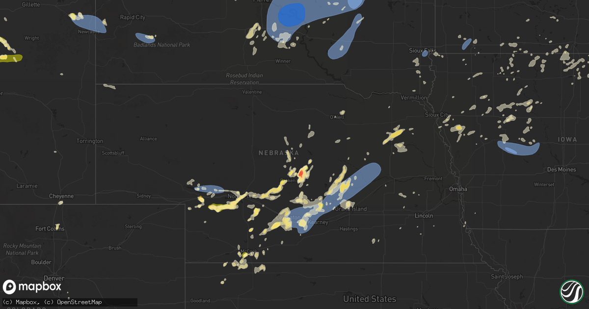
Hail Map in Nebraska on July 23, 2025
Get this storm
July 23 map
$229
one time, instant access
Download today. No call, no setup
Keep the $229
Bought the map and want the full workflow? Apply the entire $229 to a subscription within 7 days. None of it is wasted.
Every map, not just this one
This buys you this map. Subscription and you get every map we run, in the markets you choose from a few cities to whole states to nationwide. Plus real-time alerts the moment a storm fires.
Contact data
Name, contact info, occupancy, even credit band for addresses in the footprint. You go from where it hit to who to call.
Become the source they trust
Unlimited branding weather history reports on demand. You already have the documented answer ready for the property owner, and you are the one who showed up with it.
Property data and RoofTrace estimates
Pull up any address you have got, its value and the exact code rules for that jurisdiction, straight from One Click Code. Then RoofTrace estimates the squares, pitch, and roof value, priced the way you price.
Storm reports in Nebraska
Nebraska
| Date | Description |
|---|---|
| 07/23/20256:54 PM CDT | Photo on facebook of power lines down north of kearney. Time estimated from radar. |
| 07/23/20256:46 PM CDT | Personal weather station reports gust to 58mph. |
| 07/23/20256:34 PM CDT | Personal weather station reports gust to 72mph. |
| 07/23/20256:00 PM CDT | Pws measured wind gust. |
| 07/23/20255:50 PM CDT | A local report indicates 2.50 inch wind near 2 NW Weissert |
| 07/23/20255:15 PM CDT | Delayed report. No damage observed but multiple reports of a brief touchdown. |
| 07/23/20254:15 PM CDT | A local report indicates 1.00 inch wind near 11 N Dickens |
| 07/23/20254:11 PM CDT | Delayed report. Brief touchdown. No damage reported. |
| 07/23/20253:55 PM CDT | A local report indicates 1.00 inch wind near 5 SW Mccook |
| 07/23/20253:54 PM CDT | Ems reports ping pong ball sized hail. Picture sent via nwschat. |
| 07/23/20252:57 PM CDT | Up sensor measured wind gusts associated with thunderstorms. |
| 07/23/20252:28 PM CDT | Dispatch reports ping pong sized hail in town. |
| 07/22/20259:42 PM CDT | 6-8 inch tree limb broken off tree. Public report and photo received via social media. Report time based on radar. |
| 07/22/20258:57 PM CDT | Report of gusts around 60 mph on the nw side of columbus via social media. |
| 07/22/20258:45 PM CDT | Trees uprooted and power lines down in st edward. |
| 07/22/20258:40 PM CDT | A local report indicates 61 MPH wind near 2 W Saint Edward |
| 07/22/20258:09 PM CDT | Emergency manager reports trees down on powerlines in fullerton. |
| 07/22/20257:54 PM CDT | Powerline down abbott/north rd and it is sparking. Relayed by emergency manager. |
| 07/22/20257:53 PM CDT | Davis weather station. |
| 07/22/20257:40 PM CDT | Emergency manager reported downed trees... Damage to an outbuilding... And a segment of the ballfields fence was blown over. |
| 07/22/20257:40 PM CDT | Social media report with photo of a large elm tree branch down in town. |
| 07/22/20257:32 PM CDT | Dispatcher reported an outbuilding blown down in town. Time estimated based on radar. |
| 07/22/20257:32 PM CDT | Social media report of a hackberry tree blown down. |
| 07/22/20257:23 PM CDT | Personal weather station reports gust to 58mph. |
| 07/22/20257:22 PM CDT | 911 dispatch center reports power lines down in boelus. Time estimated from radar. |
| 07/22/20257:21 PM CDT | Broadcast media reports several branches of 4 to 8 inches in diameter down in wood river. Largest branches were around 10 to 12 inches in diameter. |
| 07/22/20257:21 PM CDT | Personal weather station reports gust to 73mph. |
| 07/22/20257:19 PM CDT | Personal weather station reports gust to 59mph. |
| 07/22/20257:18 PM CDT | Emergency manager reports power lines down in ravenna. Time estimated from radar. |
| 07/22/20257:17 PM CDT | Boelus fire chief reports 60-70mph winds in boelus. |
| 07/22/20257:16 PM CDT | Video shared on social media of a large tree branch that was broken off and had landed on top of a pickup. |
| 07/22/20257:12 PM CDT | Emergency manager reports 70mph winds in ravenna. |
| 07/22/20257:12 PM CDT | Photo from emergency manager of a destroyed shed north of ravenna. Time estimated from radar. |
| 07/22/20257:10 PM CDT | Delayed social media report of hail ranging in size from peas to quarters. |
| 07/22/20257:10 PM CDT | Delayed social media report o |
All States Impacted by Hail Map on July 23, 2025
Cities Impacted by Hail Map on July 23, 2025
- Stickney, SD
- Plankinton, SD
- Hamill, SD
- Ideal, SD
- Laporte, MN
- Akeley, MN
- Deer River, MN
- Wood, SD
- Presho, SD
- Gregory, SD
- White River, SD
- Bena, MN
- Kennebec, SD
- Walker, MN
- Hoven, SD
- Hardin, MT
- Selby, SD
- Gettysburg, SD
- Java, SD
- Agar, SD
- Glenham, SD
- Akaska, SD
- Eagle Butte, SD
- Bowdle, SD
- Onaka, SD
- Seneca, SD
- Onida, SD
- Tolstoy, SD
- Lebanon, SD
- Roscoe, SD
- Faulkton, SD
- Corsica, SD
- Platte, SD
- Kimball, SD
- Harrison, SD
- White Lake, SD
- Mount Vernon, SD
- Letcher, SD
- Miller, SD
- Murdo, SD
- Reliance, SD
- Vivian, SD
- Ipswich, SD
- Orient, SD
- Cresbard, SD
- Fort Thompson, SD
- Hayes, SD
- Fort Pierre, SD
- Draper, SD
- Bovey, MN
- Gann Valley, SD
- Saint Lawrence, SD
- Woonsocket, SD
- Chamberlain, SD
- Lower Brule, SD
- Wessington, SD
- Artesian, SD
- Cohasset, MN
- Mansfield, SD
- Northville, SD
- Rockham, SD
- Ashton, SD
- Pierre, SD
- Ree Heights, SD
- Stephan, SD
- Blunt, SD
- Holabird, SD
- Harrold, SD
- Highmore, SD
- Grand Rapids, MN
- Wessington Springs, SD
- Willow Lake, SD
- Virgil, SD
- Aberdeen, SD
- Warner, SD
- Mellette, SD
- Redfield, SD
- Bryant, SD
- Hayti, SD
- Hazel, SD
- Hitchcock, SD
- Wolsey, SD
- Huron, SD
- Cavour, SD
- Alpena, SD
- Otter, MT
- Tulare, SD
- Yale, SD
- Carpenter, SD
- Iroquois, SD
- Doland, SD
- Frankfort, SD
- Raymond, SD
- Clark, SD
- Turton, SD
- Garden City, SD
- Conde, SD
- Brentford, SD
- Henry, SD
- Vienna, SD
- Stratford, SD
- Bradley, SD
- Andover, SD
- Groton, SD
- Webster, SD
- Bristol, SD
- Florence, SD
- Wallace, SD
- Siren, WI
- Fairhope, AL
- Kaycee, WY
- Lewellen, NE
- Ryegate, MT
- Iuka, MS
- Ogallala, NE
- Buffalo, WY
- Eleva, WI
- Lemoyne, NE
- Mondovi, WI
- Strum, WI
- Osseo, WI
- Venango, NE
- Kinmundy, IL
- Marion, IL
- Paxton, NE
- Keystone, NE
- Creal Springs, IL
- Grant, NE
- Lavina, MT
- Stanley, WI
- Madrid, NE
- Elsie, NE
- Greenwood, WI
- Broadview, MT
- Gillette, WY
- Alma, WI
- Iuka, IL
- McCook, NE
- North Platte, NE
- Hershey, NE
- Wallace, NE
- Owen, WI
- Midwest, WY
- Independence, WI
- Whitehall, WI
- Burwell, NE
- Fort Collins, CO
- Acton, MT
- Merna, NE
- Callaway, NE
- Brady, NE
- Culbertson, NE
- Herndon, KS
- Imperial, NE
- Ringle, WI
- Schofield, WI
- Sutherland, NE
- Glenrock, WY
- Lebanon, NE
- Indianola, NE
- Wheatland, WY
- Chambers, NE
- Sargent, NE
- Dickens, NE
- Birnamwood, WI
- Hatley, WI
- Biloxi, MS
- Ault, CO
- Wellfleet, NE
- Maywood, NE
- Comstock, NE
- Mattoon, WI
- McDonald, KS
- Altura, MN
- Ashland, KS
- Aniwa, WI
- Bartley, NE
- Moorefield, NE
- Danbury, NE
- Antigo, WI
- Mosinee, WI
- Maxwell, NE
- Upton, WY
- Booker, TX
- Broken Bow, NE
- Curtis, NE
- Rosholt, WI
- Bowler, WI
- Wittenberg, WI
- Neopit, WI
- Tigerton, WI
- Osage, WY
- Atwood, KS
- Gothenburg, NE
- Ewing, NE
- Gresham, WI
- Hanlontown, IA
- Kensett, IA
- Fertile, IA
- Brewster, NE
- Keshena, WI
- Broadus, MT
- Billings, MT
- Douglas, WY
- Ansley, NE
- Westerville, NE
- Iola, WI
- Ventura, IA
- Garner, IA
- Oberlin, KS
- Cambridge, NE
- Newcastle, WY
- Arapahoe, NE
- Sundance, WY
- Moorcroft, WY
- Hill City, SD
- Westbrook, TX
- Bassett, NE
- Suring, WI
- Stockville, NE
- Gillett, WI
- Pound, WI
- Farnam, NE
- Marion, WI
- Boaz, KY
- Hickory, KY
- Cheyenne, WY
- Pampa, TX
- Miami, TX
- Canadian, TX
- Mobeetie, TX
- Perryton, TX
- Custer, SD
- Anselmo, NE
- Saint Charles, MN
- Eustis, NE
- Lance Creek, WY
- Forest City, IA
- Cozad, NE
- Dannebrog, NE
- Taylor, NE
- Clintonville, WI
- Shiocton, WI
- Bear Creek, WI
- Lena, WI
- Oconto Falls, WI
- Oconto, WI
- New London, WI
- Manawa, WI
- Ogdensburg, WI
- Black Creek, WI
- Appleton, WI
- Nichols, WI
- Kaukauna, WI
- Seymour, WI
- Cecil, WI
- Shawano, WI
- Abrams, WI
- Peshtigo, WI
- Elwood, NE
- Oconto, NE
- Fountain, MN
- Chatfield, MN
- Mason City, NE
- Oneill, NE
- Saint Paul, NE
- Coleman, WI
- Lexington, NE
- Lake Mills, IA
- Leland, IA
- Spring Valley, MN
- Clear Lake, IA
- Oneida, WI
- Green Bay, WI
- De Pere, WI
- Bonduel, WI
- Marinette, WI
- Denmark, WI
- Wrightstown, WI
- Greenleaf, WI
- Colorado City, TX
- Norcatur, KS
- Joice, IA
- Loomis, NE
- Smithfield, NE
- Holdrege, NE
- Elm Creek, NE
- Lawton, IA
- Wolbach, NE
- Valley Springs, SD
- Brandon, SD
- Eddyville, NE
- Sumner, NE
- Larchwood, IA
- Lanesboro, MN
- Maribel, WI
- Colby, KS
- Brussels, WI
- Elizabeth, CO
- Franktown, CO
- Overton, NE
- Lennox, SD
- Chancellor, SD
- Tea, SD
- Stratton, NE
- Hills, MN
- Amelia, NE
- Bronson, IA
- Hermosa, SD
- Keystone, SD
- Salix, IA
- Lismore, MN
- Bertrand, NE
- Shelton, NE
- Odessa, NE
- Miller, NE
- Heartwell, NE
- Hildreth, NE
- Ravenna, NE
- Amherst, NE
- Holstein, NE
- Kearney, NE
- Minden, NE
- Hazard, NE
- Gibbon, NE
- Juniata, NE
- Axtell, NE
- Pleasanton, NE
- Funk, NE
- Kenesaw, NE
- Roseland, NE
- Wood River, NE
- Riverdale, NE
- Worthington, MN
- Hammond, MT
- Ord, NE
- Follett, TX
- Wilmont, MN
- Manly, IA
- Northwood, IA
- Trimont, MN
- Welcome, MN
- Madelia, MN
- Rock Rapids, IA
- Elba, NE
- Ashton, NE
- Scotia, NE
- Reading, MN
- Rushmore, MN
- Saint Ansgar, IA
- Sheridan, WY
- Brewster, MN
- Swea City, IA
- Bancroft, IA
- Cairo, NE
- Rockville, NE
- Boelus, NE
- Jackson, MN
- Greeley, NE
- Emmons, MN
- Scarville, IA
- Centerville, SD
- Parker, CO
- Farwell, NE
- Loup City, NE
- Capitol, MT
- Litchfield, NE
- Grand Island, NE
- Saint Libory, NE
- Janesville, MN
- Mankato, MN
- Saint Clair, MN
- Pierson, IA
- Sherburn, MN
- Beresford, SD
- Spalding, NE
- Harrison, NE
- Worthing, SD
- Palmer, NE
- Scenic, SD
- Conger, MN
- Albert Lea, MN
- Alden, MN
- Cedar Rapids, NE
- Petersburg, NE
- Correctionville, IA
- Washta, IA
- Quimby, IA
- Vermillion, SD
- North Loup, NE
- Blue Earth, MN
- Easton, MN
- Bricelyn, MN
- Pemberton, MN
- Alcester, SD
- Cherokee, IA
- Delavan, MN
- Sibley, IA
- Fairmont, MN
- Dodge Center, MN
- Round Lake, MN
- Ceylon, MN
- Ashton, IA
- Wells, MN
- Ocheyedan, IA
- Kiester, MN
- Albion, NE
- Storm Lake, IA
- Pine Island, MN
- West Concord, MN
- Ledyard, IA
- Battle Creek, NE
- Winnebago, MN
- Estherville, IA
- Primghar, IA
- Archer, IA
- Genoa, NE
- Belgrade, NE
- Fullerton, NE
- Saint Edward, NE
- Central City, NE
- Archer, NE
- Norfolk, NE
- Terril, IA
- Ruthven, IA
- Graettinger, IA
- Lakota, IA
- Northfield, MN
- Le Mars, IA
- Frost, MN
- Buffalo Center, IA
- Dunnell, MN
- Hartley, IA
- Newman Grove, NE
- Lindsay, NE
- Monroe, NE
- Wallingford, IA
- Titonka, IA
- Pierce, NE
- Dickens, IA
- Winside, NE
- Hoskins, NE
- Newell, IA
- Spencer, IA
- Stanton, NE
- Rising City, NE
- Aurelia, IA
- Randolph, NE
- Crofton, NE
- Bloomfield, NE
- Rolfe, IA
- Havelock, IA
- Madison, NE
- Emmetsburg, IA
- Cylinder, IA
- Onawa, IA
- Osceola, NE
- West Bend, IA
- Castana, IA
- Mapleton, IA
- Carroll, NE
- Brainard, NE
- Alta, IA
- David City, NE
- Fenton, IA
- Lone Rock, IA
- Ayrshire, IA
- Weston, WY
- Danbury, IA
- Battle Creek, IA
- Pilger, NE
- Adams, MN
- Valparaiso, NE
- Weston, NE
- Palmer, IA
- Dexter, MN
- Brownsdale, MN
- Austin, MN
- Lyle, MN
- Rose Creek, MN
- Wayne, NE
- Fort Stockton, TX
- Wakefield, NE
- Smithland, IA
- Oto, IA
- Rodney, IA
- Gilmore City, IA
- Humboldt, IA
- Ulysses, NE
- Rembrandt, IA
- Grand Meadow, MN
- Galva, IA
- Schaller, IA
- Dwight, NE
- Clare, IA
- Seward, NE
- Staplehurst, NE
- Anthon, IA
- Hornick, IA
- Pocahontas, IA
- Fonda, IA
- Friend, NE
- Grafton, IA
- Plymouth, IA
- Thor, IA
- Mason City, IA
- Osage, IA
- Thornton, IA
- Varina, IA
- Edgar, NE
- Ong, NE
- Jolley, IA
- Sac City, IA
- Nora Springs, IA
- Lytton, IA
- Rockwell City, IA
- Fort Dodge, IA
- Barnum, IA
- Denison, IA
- Schleswig, IA
- Shickley, NE
- Davenport, NE
- Lake View, IA
- Moville, IA
- Somers, IA
- Moorland, IA
- Callender, IA
- Cortland, NE
- Dow City, IA
- Carroll, IA
- Deloit, IA
- Gowrie, IA
- Farnhamville, IA
- Lohrville, IA
- Breda, IA
- Clatonia, NE
- Churdan, IA
- Scranton, IA
- Templeton, IA
- Halbur, IA
- Manning, IA
- Arcadia, IA
- Westside, IA
- Glidden, IA
- Crete, NE
- Bennet, NE
- Jefferson, IA
- Paton, IA
- Grand Junction, IA
- Dana, IA
- Randolph, IA
- Firth, NE
- Dedham, IA
- Coon Rapids, IA
- Bagley, IA
- Jamaica, IA
- Rippey, IA
- Bayard, IA
- Yale, IA
- Ogden, IA
- Perry, IA
- Dawson, IA
- Hallam, NE
- Percival, IA
- Nebraska City, NE
- Shawmut, MT
- Adrian, MN
- Ellsworth, MN
- Bigelow, MN
- Harrisburg, SD
- Davis, SD
- Sioux Falls, SD
- Canton, SD


