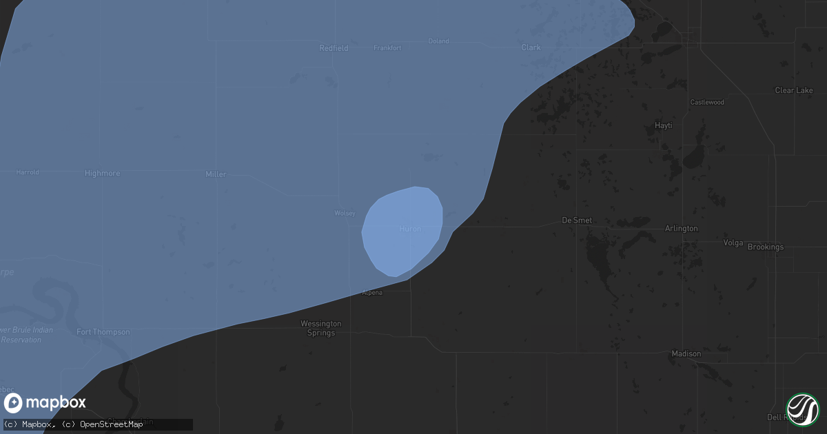
Hail Map in Huron, SD on July 23, 2025
Get this storm
July 23 map
$229
one time, instant access
Download today. No call, no setup
Keep the $229
Bought the map and want the full workflow? Apply the entire $229 to a subscription within 7 days. None of it is wasted.
Every map, not just this one
This buys you this map. Subscription and you get every map we run, in the markets you choose from a few cities to whole states to nationwide. Plus real-time alerts the moment a storm fires.
Contact data
Name, contact info, occupancy, even credit band for addresses in the footprint. You go from where it hit to who to call.
Become the source they trust
Unlimited branding weather history reports on demand. You already have the documented answer ready for the property owner, and you are the one who showed up with it.
Property data and RoofTrace estimates
Pull up any address you have got, its value and the exact code rules for that jurisdiction, straight from One Click Code. Then RoofTrace estimates the squares, pitch, and roof value, priced the way you price.
Storm reports in Huron, SD
Huron, SD
| Date | Description |
|---|---|
| 07/23/20259:33 AM CDT | Roof blown off post frame building. Time estimated from radar. |
| 07/23/20259:28 AM CDT | Roof blown off of a metal shed along the south shore of lake byron. Time estimated by radar. |
| 07/23/20259:21 AM CDT | 71 mph gust recorded at a personal weather station. |
| 07/23/20259:18 AM CDT | About 20 trees downed at golf course. Time estimated based on khon asos observation. |
| 07/23/20259:15 AM CDT | Large tree down in huron near the intersection of 7th st. And dakota ave. |
| 07/23/20259:11 AM CDT | Asos station khon huron regional airport. Gusted again to 82 mph at 9:18 am. |
| 07/23/20259:11 AM CDT | 64 mph gust recorded at a personal weather station. |
| 07/23/20259:03 AM CDT | Asos station khon huron regional airport. |
All States Impacted by Hail Map on July 23, 2025
All Cities Impacted by Hail Map on July 23, 2025
- Stickney, SD
- Plankinton, SD
- Hamill, SD
- Ideal, SD
- Laporte, MN
- Akeley, MN
- Deer River, MN
- Wood, SD
- Presho, SD
- Gregory, SD
- White River, SD
- Bena, MN
- Kennebec, SD
- Walker, MN
- Hoven, SD
- Hardin, MT
- Selby, SD
- Gettysburg, SD
- Java, SD
- Agar, SD
- Glenham, SD
- Akaska, SD
- Eagle Butte, SD
- Bowdle, SD
- Onaka, SD
- Seneca, SD
- Onida, SD
- Tolstoy, SD
- Lebanon, SD
- Roscoe, SD
- Faulkton, SD
- Corsica, SD
- Platte, SD
- Kimball, SD
- Harrison, SD
- White Lake, SD
- Mount Vernon, SD
- Letcher, SD
- Miller, SD
- Murdo, SD
- Reliance, SD
- Vivian, SD
- Ipswich, SD
- Orient, SD
- Cresbard, SD
- Fort Thompson, SD
- Hayes, SD
- Fort Pierre, SD
- Draper, SD
- Bovey, MN
- Gann Valley, SD
- Saint Lawrence, SD
- Woonsocket, SD
- Chamberlain, SD
- Lower Brule, SD
- Wessington, SD
- Artesian, SD
- Cohasset, MN
- Mansfield, SD
- Northville, SD
- Rockham, SD
- Ashton, SD
- Pierre, SD
- Ree Heights, SD
- Stephan, SD
- Blunt, SD
- Holabird, SD
- Harrold, SD
- Highmore, SD
- Grand Rapids, MN
- Wessington Springs, SD
- Willow Lake, SD
- Virgil, SD
- Aberdeen, SD
- Warner, SD
- Mellette, SD
- Redfield, SD
- Bryant, SD
- Hayti, SD
- Hazel, SD
- Hitchcock, SD
- Wolsey, SD
- Huron, SD
- Cavour, SD
- Alpena, SD
- Otter, MT
- Tulare, SD
- Yale, SD
- Carpenter, SD
- Iroquois, SD
- Doland, SD
- Frankfort, SD
- Raymond, SD
- Clark, SD
- Turton, SD
- Garden City, SD
- Conde, SD
- Brentford, SD
- Henry, SD
- Vienna, SD
- Stratford, SD
- Bradley, SD
- Andover, SD
- Groton, SD
- Webster, SD
- Bristol, SD
- Florence, SD
- Wallace, SD
- Siren, WI
- Fairhope, AL
- Kaycee, WY
- Lewellen, NE
- Ryegate, MT
- Iuka, MS
- Ogallala, NE
- Buffalo, WY
- Eleva, WI
- Lemoyne, NE
- Mondovi, WI
- Strum, WI
- Osseo, WI
- Venango, NE
- Kinmundy, IL
- Marion, IL
- Paxton, NE
- Keystone, NE
- Creal Springs, IL
- Grant, NE
- Lavina, MT
- Stanley, WI
- Madrid, NE
- Elsie, NE
- Greenwood, WI
- Broadview, MT
- Gillette, WY
- Alma, WI
- Iuka, IL
- McCook, NE
- North Platte, NE
- Hershey, NE
- Wallace, NE
- Owen, WI
- Midwest, WY
- Independence, WI
- Whitehall, WI
- Burwell, NE
- Fort Collins, CO
- Acton, MT
- Merna, NE
- Callaway, NE
- Brady, NE
- Culbertson, NE
- Herndon, KS
- Imperial, NE
- Ringle, WI
- Schofield, WI
- Sutherland, NE
- Glenrock, WY
- Lebanon, NE
- Indianola, NE
- Wheatland, WY
- Chambers, NE
- Sargent, NE
- Dickens, NE
- Birnamwood, WI
- Hatley, WI
- Biloxi, MS
- Ault, CO
- Wellfleet, NE
- Maywood, NE
- Comstock, NE
- Mattoon, WI
- McDonald, KS
- Altura, MN
- Ashland, KS
- Aniwa, WI
- Bartley, NE
- Moorefield, NE
- Danbury, NE
- Antigo, WI
- Mosinee, WI
- Maxwell, NE
- Upton, WY
- Booker, TX
- Broken Bow, NE
- Curtis, NE
- Rosholt, WI
- Bowler, WI
- Wittenberg, WI
- Neopit, WI
- Tigerton, WI
- Osage, WY
- Atwood, KS
- Gothenburg, NE
- Ewing, NE
- Gresham, WI
- Hanlontown, IA
- Kensett, IA
- Fertile, IA
- Brewster, NE
- Keshena, WI
- Broadus, MT
- Billings, MT
- Douglas, WY
- Ansley, NE
- Westerville, NE
- Iola, WI
- Ventura, IA
- Garner, IA
- Oberlin, KS
- Cambridge, NE
- Newcastle, WY
- Arapahoe, NE
- Sundance, WY
- Moorcroft, WY
- Hill City, SD
- Westbrook, TX
- Bassett, NE
- Suring, WI
- Stockville, NE
- Gillett, WI
- Pound, WI
- Farnam, NE
- Marion, WI
- Boaz, KY
- Hickory, KY
- Cheyenne, WY
- Pampa, TX
- Miami, TX
- Canadian, TX
- Mobeetie, TX
- Perryton, TX
- Custer, SD
- Anselmo, NE
- Saint Charles, MN
- Eustis, NE
- Lance Creek, WY
- Forest City, IA
- Cozad, NE
- Dannebrog, NE
- Taylor, NE
- Clintonville, WI
- Shiocton, WI
- Bear Creek, WI
- Lena, WI
- Oconto Falls, WI
- Oconto, WI
- New London, WI
- Manawa, WI
- Ogdensburg, WI
- Black Creek, WI
- Appleton, WI
- Nichols, WI
- Kaukauna, WI
- Seymour, WI
- Cecil, WI
- Shawano, WI
- Abrams, WI
- Peshtigo, WI
- Elwood, NE
- Oconto, NE
- Fountain, MN
- Chatfield, MN
- Mason City, NE
- Oneill, NE
- Saint Paul, NE
- Coleman, WI
- Lexington, NE
- Lake Mills, IA
- Leland, IA
- Spring Valley, MN
- Clear Lake, IA
- Oneida, WI
- Green Bay, WI
- De Pere, WI
- Bonduel, WI
- Marinette, WI
- Denmark, WI
- Wrightstown, WI
- Greenleaf, WI
- Colorado City, TX
- Norcatur, KS
- Joice, IA
- Loomis, NE
- Smithfield, NE
- Holdrege, NE
- Elm Creek, NE
- Lawton, IA
- Wolbach, NE
- Valley Springs, SD
- Brandon, SD
- Eddyville, NE
- Sumner, NE
- Larchwood, IA
- Lanesboro, MN
- Maribel, WI
- Colby, KS
- Brussels, WI
- Elizabeth, CO
- Franktown, CO
- Overton, NE
- Lennox, SD
- Chancellor, SD
- Tea, SD
- Stratton, NE
- Hills, MN
- Amelia, NE
- Bronson, IA
- Hermosa, SD
- Keystone, SD
- Salix, IA
- Lismore, MN
- Bertrand, NE
- Shelton, NE
- Odessa, NE
- Miller, NE
- Heartwell, NE
- Hildreth, NE
- Ravenna, NE
- Amherst, NE
- Holstein, NE
- Kearney, NE
- Minden, NE
- Hazard, NE
- Gibbon, NE
- Juniata, NE
- Axtell, NE
- Pleasanton, NE
- Funk, NE
- Kenesaw, NE
- Roseland, NE
- Wood River, NE
- Riverdale, NE
- Worthington, MN
- Hammond, MT
- Ord, NE
- Follett, TX
- Wilmont, MN
- Manly, IA
- Northwood, IA
- Trimont, MN
- Welcome, MN
- Madelia, MN
- Rock Rapids, IA
- Elba, NE
- Ashton, NE
- Scotia, NE
- Reading, MN
- Rushmore, MN
- Saint Ansgar, IA
- Sheridan, WY
- Brewster, MN
- Swea City, IA
- Bancroft, IA
- Cairo, NE
- Rockville, NE
- Boelus, NE
- Jackson, MN
- Greeley, NE
- Emmons, MN
- Scarville, IA
- Centerville, SD
- Parker, CO
- Farwell, NE
- Loup City, NE
- Capitol, MT
- Litchfield, NE
- Grand Island, NE
- Saint Libory, NE
- Janesville, MN
- Mankato, MN
- Saint Clair, MN
- Pierson, IA
- Sherburn, MN
- Beresford, SD
- Spalding, NE
- Harrison, NE
- Worthing, SD
- Palmer, NE
- Scenic, SD
- Conger, MN
- Albert Lea, MN
- Alden, MN
- Cedar Rapids, NE
- Petersburg, NE
- Correctionville, IA
- Washta, IA
- Quimby, IA
- Vermillion, SD
- North Loup, NE
- Blue Earth, MN
- Easton, MN
- Bricelyn, MN
- Pemberton, MN
- Alcester, SD
- Cherokee, IA
- Delavan, MN
- Sibley, IA
- Fairmont, MN
- Dodge Center, MN
- Round Lake, MN
- Ceylon, MN
- Ashton, IA
- Wells, MN
- Ocheyedan, IA
- Kiester, MN
- Albion, NE
- Storm Lake, IA
- Pine Island, MN
- West Concord, MN
- Ledyard, IA
- Battle Creek, NE
- Winnebago, MN
- Estherville, IA
- Primghar, IA
- Archer, IA
- Genoa, NE
- Belgrade, NE
- Fullerton, NE
- Saint Edward, NE
- Central City, NE
- Archer, NE
- Norfolk, NE
- Terril, IA
- Ruthven, IA
- Graettinger, IA
- Lakota, IA
- Northfield, MN
- Le Mars, IA
- Frost, MN
- Buffalo Center, IA
- Dunnell, MN
- Hartley, IA
- Newman Grove, NE
- Lindsay, NE
- Monroe, NE
- Wallingford, IA
- Titonka, IA
- Pierce, NE
- Dickens, IA
- Winside, NE
- Hoskins, NE
- Newell, IA
- Spencer, IA
- Stanton, NE
- Rising City, NE
- Aurelia, IA
- Randolph, NE
- Crofton, NE
- Bloomfield, NE
- Rolfe, IA
- Havelock, IA
- Madison, NE
- Emmetsburg, IA
- Cylinder, IA
- Onawa, IA
- Osceola, NE
- West Bend, IA
- Castana, IA
- Mapleton, IA
- Carroll, NE
- Brainard, NE
- Alta, IA
- David City, NE
- Fenton, IA
- Lone Rock, IA
- Ayrshire, IA
- Weston, WY
- Danbury, IA
- Battle Creek, IA
- Pilger, NE
- Adams, MN
- Valparaiso, NE
- Weston, NE
- Palmer, IA
- Dexter, MN
- Brownsdale, MN
- Austin, MN
- Lyle, MN
- Rose Creek, MN
- Wayne, NE
- Fort Stockton, TX
- Wakefield, NE
- Smithland, IA
- Oto, IA
- Rodney, IA
- Gilmore City, IA
- Humboldt, IA
- Ulysses, NE
- Rembrandt, IA
- Grand Meadow, MN
- Galva, IA
- Schaller, IA
- Dwight, NE
- Clare, IA
- Seward, NE
- Staplehurst, NE
- Anthon, IA
- Hornick, IA
- Pocahontas, IA
- Fonda, IA
- Friend, NE
- Grafton, IA
- Plymouth, IA
- Thor, IA
- Mason City, IA
- Osage, IA
- Thornton, IA
- Varina, IA
- Edgar, NE
- Ong, NE
- Jolley, IA
- Sac City, IA
- Nora Springs, IA
- Lytton, IA
- Rockwell City, IA
- Fort Dodge, IA
- Barnum, IA
- Denison, IA
- Schleswig, IA
- Shickley, NE
- Davenport, NE
- Lake View, IA
- Moville, IA
- Somers, IA
- Moorland, IA
- Callender, IA
- Cortland, NE
- Dow City, IA
- Carroll, IA
- Deloit, IA
- Gowrie, IA
- Farnhamville, IA
- Lohrville, IA
- Breda, IA
- Clatonia, NE
- Churdan, IA
- Scranton, IA
- Templeton, IA
- Halbur, IA
- Manning, IA
- Arcadia, IA
- Westside, IA
- Glidden, IA
- Crete, NE
- Bennet, NE
- Jefferson, IA
- Paton, IA
- Grand Junction, IA
- Dana, IA
- Randolph, IA
- Firth, NE
- Dedham, IA
- Coon Rapids, IA
- Bagley, IA
- Jamaica, IA
- Rippey, IA
- Bayard, IA
- Yale, IA
- Ogden, IA
- Perry, IA
- Dawson, IA
- Hallam, NE
- Percival, IA
- Nebraska City, NE
- Shawmut, MT
- Adrian, MN
- Ellsworth, MN
- Bigelow, MN
- Harrisburg, SD
- Davis, SD
- Sioux Falls, SD
- Canton, SD


