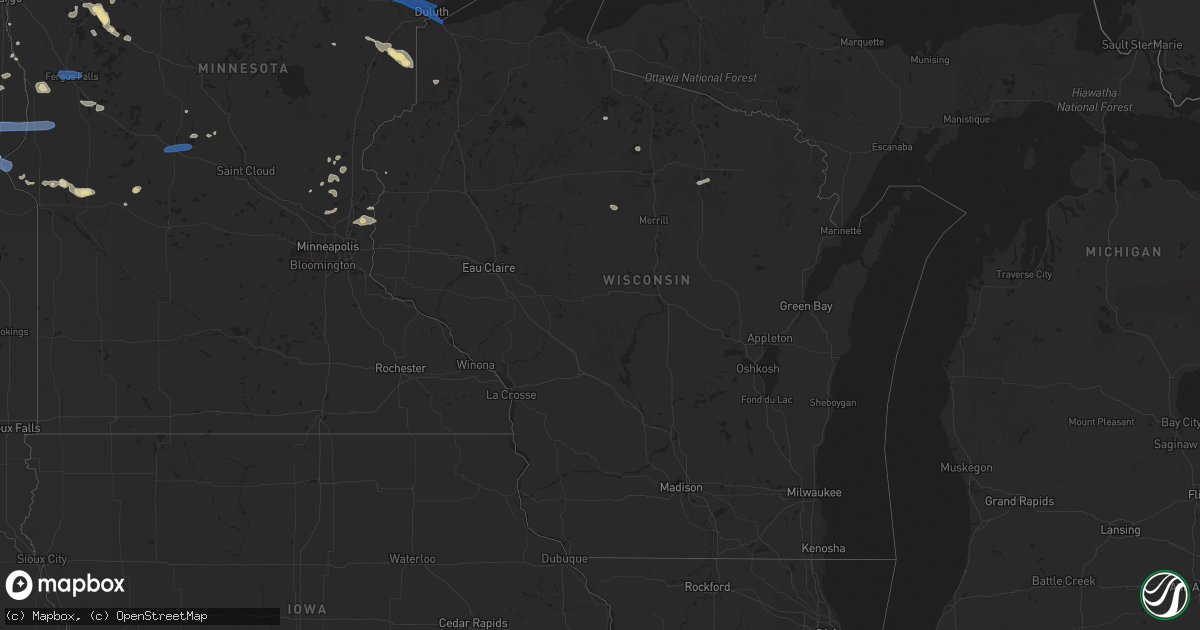
Hail Map in Wisconsin on July 23, 2021
Get this storm
July 23 map
$229
one time, instant access
Download today. No call, no setup
Keep the $229
Bought the map and want the full workflow? Apply the entire $229 to a subscription within 7 days. None of it is wasted.
Every map, not just this one
This buys you this map. Subscription and you get every map we run, in the markets you choose from a few cities to whole states to nationwide. Plus real-time alerts the moment a storm fires.
Contact data
Name, contact info, occupancy, even credit band for addresses in the footprint. You go from where it hit to who to call.
Become the source they trust
Unlimited branding weather history reports on demand. You already have the documented answer ready for the property owner, and you are the one who showed up with it.
Property data and RoofTrace estimates
Pull up any address you have got, its value and the exact code rules for that jurisdiction, straight from One Click Code. Then RoofTrace estimates the squares, pitch, and roof value, priced the way you price.
Storm reports in Wisconsin
Wisconsin
| Date | Description |
|---|---|
| 07/23/20213:56 AM CDT | At 856 PM CDT, a severe thunderstorm was located over Pike Lake Near Duluth, or 9 miles northwest of Duluth, moving east at 35 mph. HAZARD...60 mph wind gusts and penny size hail. SOURCE...Radar indicated. IMPACT...Expect damage to roofs, siding, and trees. This severe thunderstorm will be near... Hermantown and Proctor around 905 PM CDT. Superior and City of Rice Lake around 915 PM CDT.Other locations in the path of this severe thunderstorm includeDuluth and French River. |
| 07/22/202110:59 PM CDT | Trees down and power out near cozy corner - not witnessed first hand. Time and location estimated by radar. |
All States Impacted by Hail Map on July 23, 2021
Cities Impacted by Hail Map on July 23, 2021
- Saint Johns, AZ
- Meadowlands, MN
- Floodwood, MN
- Napoleon, ND
- Stirum, ND
- Gwinner, ND
- Oakes, ND
- Socorro, NM
- Dawson, ND
- Shields, ND
- Selfridge, ND
- Solen, ND
- Madison, NH
- Silver Lake, NH
- Freedom, NH
- Cook, MN
- Pie Town, NM
- Willard, NM
- Elk River, MN
- Saint Francis, MN
- Danvers, MA
- Barnum, MN
- Holyoke, MN
- Kerrick, MN
- Orr, MN
- Tower, MN
- Mooreton, ND
- Barney, ND
- Lake Wales, FL
- Prairie City, SD
- New Leipzig, ND
- Sisseton, SD
- Moriarty, NM
- Wood Lake, NE
- Remer, MN
- Reva, SD
- Hankinson, ND
- Mantador, ND
- Tierra Amarilla, NM
- Contoocook, NH
- Harris, MN
- North Branch, MN
- Immokalee, FL
- Farmington, NM
- Solway, MN
- Bemidji, MN
- Northome, MN
- Blackduck, MN
- Kelliher, MN
- Fredonia, ND
- Mayo, FL
- Day, FL
- Wishek, ND
- Park Falls, WI
- West Bridgewater, MA
- East Bridgewater, MA
- Flasher, ND
- Squaw Lake, MN
- Mizpah, MN
- Leesburg, GA
- Smithville, GA
- Plympton, MA
- Kingston, MA
- Halifax, MA
- Ashley, ND
- Ogema, MN
- Hazelhurst, WI
- Clinton, MN
- Ortonville, MN
- Perham, MN
- Hugo, MN
- Somerset, WI
- Marine On Saint Croix, MN
- Stillwater, MN
- Magdalena, NM
- Clewiston, FL
- Detroit Lakes, MN
- Frazee, MN
- Audubon, MN
- Lake Park, MN
- Pelican Rapids, MN
- Show Low, AZ
- Littlefork, MN
- Jemez Springs, NM
- Groveland, MA
- Georgetown, MA
- Boxford, MA
- Ely, MN
- Callaway, MN
- Keldron, SD
- Lemmon, SD
- Ponemah, MN
- Bison, SD
- Wahpeton, ND
- Moffat, CO
- Stanchfield, MN
- Central, SC
- Clemson, SC
- El Rito, NM
- Beardsley, MN
- Graceville, MN
- Corrales, NM
- Nashwauk, MN
- Britton, SD
- Kintyre, ND
- Atlanta, GA
- Prescott, AZ
- Prescott Valley, AZ
- Veblen, SD
- Claire City, SD
- Winslow, AZ
- Barnesville, GA
- Milnor, ND
- Alpharetta, GA
- Claremont, SD
- Amherst, SD
- Balmorhea, TX
- West Newbury, MA
- Merrimac, MA
- Haverhill, MA
- Isanti, MN
- Cambridge, MN
- Cogswell, ND
- Park Rapids, MN
- Max, MN
- Kent, MN
- Rib Lake, WI
- Crane Lake, MN
- Rochert, MN
- Meadow, SD
- Luck, WI
- Cushing, WI
- Moorhead, MN
- Long Prairie, MN
- Lehr, ND
- Datil, NM
- Ashby, MN
- Appleton, MN
- Holloway, MN
- Hancock, MN
- International Falls, MN
- New York Mills, MN
- Vergas, MN
- Dent, MN
- Linton, ND
- East Kingston, NH
- Effingham, NH
- Ossipee, NH
- Bethel, MN
- Cedar, MN
- Leola, SD
- New Smyrna Beach, FL
- Gallup, NM
- Ash Fork, AZ
- Williams, AZ
- Akeley, MN
- Thief River Falls, MN
- Burtrum, MN
- Grey Eagle, MN
- Corona, NM
- Barnard, SD
- Kathryn, ND
- Lisbon, ND
- Jacksonville, FL
- Middleburg, FL
- Morris, MN
- Chokio, MN
- Benson, MN
- Glenwood, MN
- Murdock, MN
- Hettinger, ND
- Nevis, MN
- Wyndmere, ND
- Baileyville, ME
- Ganado, AZ
- Chino Valley, AZ
- Encino, NM
- Mcgregor, MN
- Forman, ND
- Arthur, NE
- Huron, SD
- Evansville, MN
- Summerdale, AL
- Brockton, MA
- Fence Lake, NM
- Frederick, SD
- Elbow Lake, MN
- Bunnell, FL
- Danvers, MN
- Hanson, MA
- Sargents, CO
- Cayuga, ND
- Rutland, ND
- Kingston, NH
- Newton, NH
- Bowlus, MN
- Little Falls, MN
- Wolverton, MN
- Andover, MN
- Foxhome, MN
- Campbell, MN
- Breckenridge, MN
- Danbury, WI
- Green Cove Springs, FL
- Tappen, ND
- Dry Branch, GA
- Bonaire, GA
- Warner Robins, GA
- Forbes, ND
- Rio Rancho, NM
- Grand Rapids, MN
- Inglis, FL
- Capitan, NM
- Gray, ME
- Windham, ME
- Delray Beach, FL
- Boynton Beach, FL
- Pelican Lake, WI
- Elcho, WI
- Kettle River, MN
- Moose Lake, MN
- Scandia, MN
- Swanville, MN
- Upsala, MN
- Strasburg, ND
- Isabella, MN
- Mountainair, NM
- Meredith, NH
- Moultonborough, NH
- Center Harbor, NH
- Amesbury, MA
- Exeter, NH
- Byfield, MA
- Concord, NH
- Aberdeen, SD
- Roscoe, SD
- Hosmer, SD
- Westport, SD
- Kulm, ND
- Long Lake, SD
- Columbia, SD
- Eureka, SD
- Hecla, SD
- Zeeland, ND
- Ipswich, SD
- Fullerton, ND
- Hague, ND
- Ellendale, ND
- Edgeley, ND
- Lake City, SD
- Peever, SD
- Browns Valley, MN
- New Effington, SD
- Norcross, MN
- Rosholt, SD
- Wheaton, MN
- Fergus Falls, MN
- Brookston, MN
- Saginaw, MN
- Alborn, MN
- Duluth, MN
- Superior, WI
- Cloquet, MN
- Sauk Centre, MN
- Melrose, MN


