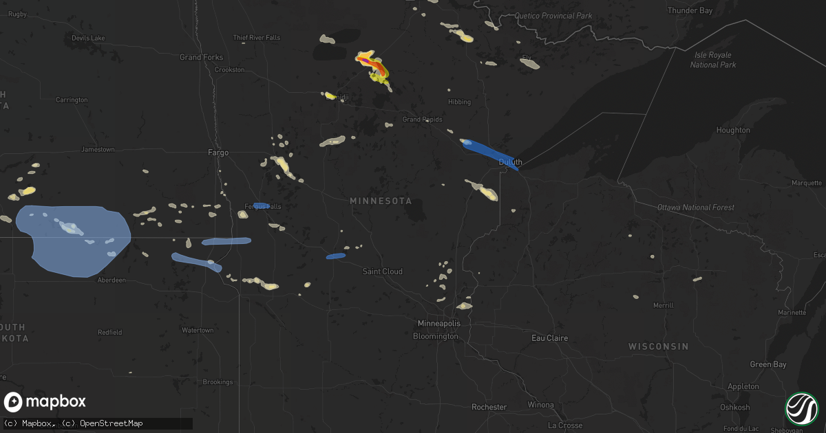
Hail Map in Minnesota on July 23, 2021
Get this storm
July 23 map
$229
one time, instant access
Download today. No call, no setup
Keep the $229
Bought the map and want the full workflow? Apply the entire $229 to a subscription within 7 days. None of it is wasted.
Every map, not just this one
This buys you this map. Subscription and you get every map we run, in the markets you choose from a few cities to whole states to nationwide. Plus real-time alerts the moment a storm fires.
Contact data
Name, contact info, occupancy, even credit band for addresses in the footprint. You go from where it hit to who to call.
Become the source they trust
Unlimited branding weather history reports on demand. You already have the documented answer ready for the property owner, and you are the one who showed up with it.
Property data and RoofTrace estimates
Pull up any address you have got, its value and the exact code rules for that jurisdiction, straight from One Click Code. Then RoofTrace estimates the squares, pitch, and roof value, priced the way you price.
Storm reports in Minnesota
Minnesota
| Date | Description |
|---|---|
| 07/23/20216:47 PM CDT | Photos and measurements were received from the damaged trees in whiteside park. The two largest trees were elms. One was uprooted and had a diameter of 1 foot at the ba |
| 07/23/20216:46 PM CDT | Photo and report received via social media of trees down and damage to tents at a festival in downtown ely. Time estimated by radar. |
| 07/23/20216:46 PM CDT | Numerous reports of trees down in ely with multiple roads blocked. Time estimated by radar. |
| 07/23/20216:42 PM CDT | Report posted via social media. Time estimated based on radar. |
| 07/23/20216:41 PM CDT | Multiple canoes flipped over from thunderstorm wind gusts on trout lake. Crew of one canoe unaccounted for. Additional water emergencies ongoing in other portions of th |
| 07/23/20216:30 PM CDT | Mulitple reports of large hail in and around bemidji. Photos and reports posted via social media. |
| 07/23/20216:30 PM CDT | Branches snapped; relayed via social media. |
| 07/23/20216:30 PM CDT | A few tress were snapped near the high school. Photos and report posted via social media. Time estimated based on radar. |
| 07/23/20216:30 PM CDT | Relayed via social media. |
| 07/23/20216:23 PM CDT | Relayed via social media. |
| 07/23/20216:23 PM CDT | Public report posted via social media. |
| 07/23/20216:15 PM CDT | Photo of several large aspen trees down on facebook. |
| 07/23/20215:50 PM CDT | Photos shared on social media shows an uprooted red pine tree as well as a white pine broken in half about halfway up the tree. Tree heights are estimated to be around |
| 07/23/20215:48 PM CDT | Report from mping: trees uprooted or snapped; roof blown off. Changed time to match radar signature. |
| 07/23/20215:39 PM CDT | The spotter reported a few trees down at his location and his power was out. |
| 07/23/20215:30 PM CDT | Spotter reported a tree down onto power lines about two miles west of their home. Time estimated by radar. |
| 07/23/20214:53 PM CDT | Numerous 1 inch diameter hail with a few to 2 inches. Earlier hail was pea to small marble sized. |
| 07/23/20214:30 PM CDT | Koochiching county dispatch reported a tree down on a power line along county road 2 just south of cripple creek. Time estimated from radar. |
| 07/23/20214:05 PM CDT | A local report indicates 1.00 inch wind near 2 NNE PONEMAH |
| 07/23/20215:59 AM CDT | At 1056 PM CDT, a severe thunderstorm was located over Dairyland, or 29 miles northwest of Spooner, moving southeast at 40 mph. HAZARD...60 mph wind gusts and penny size hail. SOURCE...Radar indicated. IMPACT...Expect damage to roofs, siding, and trees. Locations impacted include... Minong. |
| 07/23/20215:10 AM CDT | Large trees down on arrowhead rd east of the rice lake intersection. |
| 07/23/20215:06 AM CDT | A local report indicates 64 MPH wind near 3 ENE HERMANTOWN |
| 07/23/20215:04 AM CDT | A tree branch about a foot in diameter was snapped off an ash tree at the nws office. Time estimated by radar. |
| 07/23/20213:55 AM CDT | Photos sent via twitter of large tree limbs down and power line poles broken along old towne road. |
| 07/23/20213:46 AM CDT | Large tree down on state highway 200 approximately 6 miles west of hill city. Time estimated based on radar. |
| 07/23/20213:39 AM CDT | At 838 PM CDT, a severe thunderstorm was located near Brookston, or 12 miles north of Cloquet, moving east at 35 mph. HAZARD...70 mph wind gusts and penny size hail. SOURCE...Radar indicated. IMPACT...Expect considerable tree damage. Damage is likely to mobile homes, roofs, and outbuildings. This severe thunderstorm will be near... Saginaw around 850 PM CDT.Other locations in the path of this severe thunderstorm include PikeLake Near Duluth and Hermantown. |
| 07/23/20213:30 AM CDT | Numerous power lines... 18-24 inch diameter trees down in and around chisago city. Time estimated by spotter... Corroborated by radar. |
| 07/23/20213:02 AM CDT | At 801 PM CDT, a severe thunderstorm was located near Remer, or 20 miles west of Grand Rapids, moving southeast at 35 mph. HAZARD...60 mph wind gusts and nickel size hail. SOURCE...Radar indicated. IMPACT...Expect damage to roofs, siding, and trees. This severe thunderstorm will be near... Remer around 810 PM CDT.Other locations in the path of this severe thunderstorm include HillCity. |
| 07/23/20212:58 AM CDT | Report from mping: trees uprooted or snapped; roof blown off. |
| 07/23/20212:43 AM CDT | Report from mping: 1-inch tree limbs broken; shingles blown off. |
| 07/23/20212:38 AM CDT | Peak wind measured at the park rapids airport /kpkd/. |
| 07/23/20212:38 AM CDT | A local report indicates 59 MPH wind near PARK RAPIDS |
| 07/23/20212:30 AM CDT | At 729 PM CDT, severe thunderstorms were located along a line extending from Boundary Waters Canoe Area Wilderness near Snowbank Lake, to 6 miles southwest of Forest Center, to 9 miles southeast of Birch Lake, moving east at 50 mph. HAZARD...70 mph wind gusts and penny size hail. SOURCE...Radar indicated. IMPACT...Expect considerable tree damage. Damage is likely to mobile homes, roofs, and outbuildings. Severe thunderstorms will be near... Forest Center around 735 PM CDT.Other locations in the path of these severe thunderstorms includeClear Lake, Isabella, Dumbbell Lake, Lutsen, Taconite Harbor, Tofteand Grand Marais. |
| 07/23/20212:18 AM CDT | Several large tree branches and limbs were broken down. Winds estimated in excess of 60 mph. Time estimated based on radar. Widespread power outages reported. |
| 07/23/20212:06 AM CDT | Large tree branches broken down. Power outages. Time estimated based on radar. |
| 07/23/20212:03 AM CDT | Large tree branches were broken down and an awning support was snapped around the leaf lake area in central leaf lake township. Time estimated based on radar. |
| 07/23/20212:00 AM CDT | Several large tree branches and lims were broken down and a few trees snapped between lake lizzie... Pelican lake... And lake melissa. Near the otter tail and becker co |
| 07/23/20211:55 AM CDT | Corn fields snapped and flattened by wind and hail. |
| 07/23/20211:41 AM CDT | Playground moved; relayed via social media. |
| 07/23/20211:40 AM CDT | Kd39 measured a 60 mph wind gust. |
| 07/23/20211:39 AM CDT | Report from mping: 3-inch tree limbs broken; power poles broken. |
| 07/23/20211:36 AM CDT | Received reports from two different wind sensors in the barnesville area with wind gusts to 60 mph between 136 and 144 am cdt. A few large tree branches were broken dow |
| 07/23/20211:36 AM CDT | Branches up to 6 inch diameter broken down. |
| 07/23/20211:30 AM CDT | 3 inch tree limbs down. |
| 07/23/20211:30 AM CDT | Large 3 inch diameter and larger branches broken down. Winds estimated to 60 mph. |
| 07/23/20211:28 AM CDT | At 627 PM CDT, severe thunderstorms were located along a line extending from Boundary Waters Canoe Area Wilderness northwest of Ely, to 11 miles northwest of Burntside Lake, to near Lake Vermilion, moving east at 50 mph. HAZARD...70 mph wind gusts and nickel size hail. SOURCE...Radar indicated. IMPACT...Expect considerable tree damage. Damage is likely to mobile homes, roofs, and outbuildings. Severe thunderstorms will be near... Burntside Lake around 645 PM CDT.Other locations in the path of these severe thunderstorms includeEly, Winton, Robinson, White Iron Lake, Fall Lake, Basswood Lake,Snowbank Lake, Birch Lake, Babbitt, Forest Center and Little SaganagaLake. |
| 07/23/20211:22 AM CDT | At 622 PM CDT, a severe thunderstorm was located over Wilton, or near Bemidji, moving east at 40 mph. HAZARD...60 mph wind gusts and quarter size hail. SOURCE...Radar indicated. IMPACT...Hail damage to vehicles is expected. Expect wind damage to roofs, siding, and trees. Locations impacted include... Bemidji, Wilton, Lavinia, Turtle River, Guthrie, Rosby and Pennington. |
| 07/23/20211:15 AM CDT | Measured by personal weather station. |
| 07/23/20211:15 AM CDT | Peak wind measured at a personal weather station in north ottawa township. |
| 07/23/20211:08 AM CDT | Report posted via social media. |
| 07/23/202112:55 AM CDT | Large branches broken down and a tree snapped. Time estimated based on radar. |
| 07/23/202112:50 AM CDT | Tree limbs up to 4 inches diameter broken. More minor damage leading into wheaton. Time estimated based on radar. |
| 07/23/202112:50 AM CDT | Peak wind measured at a personal weather station. |
| 07/23/202112:47 AM CDT | Multiple reports received of dime to quarter sized hail received around big detroit lake. |
| 07/23/202112:47 AM CDT | Hail on east side of big detroit lake. |
| 07/23/202112:40 AM CDT | Tree branches broken; time estimated from radar. |
| 07/23/202112:34 AM CDT | At 534 PM CDT, severe thunderstorms were located along a line extending from 9 miles southeast of Mizpah, to near Squaw Lake, to 6 miles southwest of Alvwood, moving east-southeast at 30 mph. HAZARD...70 mph wind gusts and quarter size hail. SOURCE...Radar indicated. IMPACT...Hail damage to vehicles is expected. Expect considerable tree damage. Wind damage is also likely to mobile homes, roofs, and outbuildings. Severe thunderstorms will be near... Squaw Lake around 540 PM CDT. Oslund around 545 PM CDT.Other locations in the path of these severe thunderstorms includeInger, Bigfork and Marcell. |
| 07/22/202111:59 PM CDT | At 458 PM CDT, a severe thunderstorm was located near Northome, or 34 miles northeast of Bemidji, moving southeast at 15 mph. HAZARD...Two inch hail and 70 mph wind gusts. SOURCE...At 453 PM, trained weather spotters reported 2 inch hail with this storm near Shooks. IMPACT...People and animals outdoors will be injured. Expect hail damage to roofs, siding, windows, and vehicles. Expect considerable tree damage. Wind damage is also likely to mobile homes, roofs, and outbuildings. Locations impacted include... Northome and Alvwood. |
| 07/22/202111:50 PM CDT | At 450 PM CDT, a severe thunderstorm was located near Mizpah, moving northeast at 35 mph. HAZARD...70 mph wind gusts and ping pong ball size hail. SOURCE...Radar indicated. IMPACT...People and animals outdoors will be injured. Expect hail damage to roofs, siding, windows, and vehicles. Expect considerable tree damage. Wind damage is also likely to mobile homes, roofs, and outbuildings. This severe thunderstorm will be near... Mizpah around 455 PM CDT. Gemmell around 505 PM CDT.Other locations in the path of this severe thunderstorm includeMargie. |
| 07/22/202111:45 PM CDT | At 444 PM CDT, a severe thunderstorm was located over Kelliher, or 35 miles northeast of Bemidji, moving east at 10 mph. HAZARD...60 mph wind gusts and quarter size hail. SOURCE...Radar indicated. IMPACT...Hail damage to vehicles is expected. Expect wind damage to roofs, siding, and trees. This severe thunderstorm will be near... Shooks around 450 PM CDT. |
| 07/22/202111:28 PM CDT | At 428 PM CDT, severe thunderstorms were located along a line extending from near Rainy Lake West, to 6 miles south of International Falls, to near Littlefork, moving east at 35 mph. HAZARD...60 mph wind gusts and quarter size hail. SOURCE...Radar indicated. IMPACT...Hail damage to vehicles is expected. Expect wind damage to roofs, siding, and trees. Severe thunderstorms will be near... Voyageurs National Park around 435 PM CDT. Rainy Lake West around 440 PM CDT. Rainy Lake East around 445 PM CDT.Other locations in the path of these severe thunderstorms includeKabetogama and Kabetogama Lake. |
| 07/22/202110:48 PM CDT | At 347 PM CDT, a severe thunderstorm was located over northeastern Red Lake Nation, or 43 miles north of Bemidji, moving east at 40 mph. HAZARD...70 mph wind gusts and ping pong ball size hail. SOURCE...Radar indicated. IMPACT...People and animals outdoors will be injured. Expect hail damage to roofs, siding, windows, and vehicles. Expect considerable tree damage. Wind damage is also likely to mobile homes, roofs, and outbuildings. This severe thunderstorm will be near... Upper Red Lake around 350 PM CDT. Ponemah around 400 PM CDT.Other locations in the path of this severe thunderstorm includeShotley. |
| 07/22/20218:42 PM CDT | Three trees were downed 1 mile south of highway 8 along highway 7 with one tree completely blocking the road. Time estimated by radar. |
| 07/22/20218:40 PM CDT | Two trees were reported down north of highway 8 along highway 7. Time estimated by radar. |
| 07/22/20218:31 PM CDT | Nws meteorologists noted multiple trees down east of hill city along highway 200. Delayed report. Time estimated by radar. |
| 07/22/20217:45 PM CDT | Power lines were reported down on trees along mitawan lake road northwest of isabella. Time estimated by radar. |
All States Impacted by Hail Map on July 23, 2021
Cities Impacted by Hail Map on July 23, 2021
- Saint Johns, AZ
- Meadowlands, MN
- Floodwood, MN
- Napoleon, ND
- Stirum, ND
- Gwinner, ND
- Oakes, ND
- Socorro, NM
- Dawson, ND
- Shields, ND
- Selfridge, ND
- Solen, ND
- Madison, NH
- Silver Lake, NH
- Freedom, NH
- Cook, MN
- Pie Town, NM
- Willard, NM
- Elk River, MN
- Saint Francis, MN
- Danvers, MA
- Barnum, MN
- Holyoke, MN
- Kerrick, MN
- Orr, MN
- Tower, MN
- Mooreton, ND
- Barney, ND
- Lake Wales, FL
- Prairie City, SD
- New Leipzig, ND
- Sisseton, SD
- Moriarty, NM
- Wood Lake, NE
- Remer, MN
- Reva, SD
- Hankinson, ND
- Mantador, ND
- Tierra Amarilla, NM
- Contoocook, NH
- Harris, MN
- North Branch, MN
- Immokalee, FL
- Farmington, NM
- Solway, MN
- Bemidji, MN
- Northome, MN
- Blackduck, MN
- Kelliher, MN
- Fredonia, ND
- Mayo, FL
- Day, FL
- Wishek, ND
- Park Falls, WI
- West Bridgewater, MA
- East Bridgewater, MA
- Flasher, ND
- Squaw Lake, MN
- Mizpah, MN
- Leesburg, GA
- Smithville, GA
- Plympton, MA
- Kingston, MA
- Halifax, MA
- Ashley, ND
- Ogema, MN
- Hazelhurst, WI
- Clinton, MN
- Ortonville, MN
- Perham, MN
- Hugo, MN
- Somerset, WI
- Marine On Saint Croix, MN
- Stillwater, MN
- Magdalena, NM
- Clewiston, FL
- Detroit Lakes, MN
- Frazee, MN
- Audubon, MN
- Lake Park, MN
- Pelican Rapids, MN
- Show Low, AZ
- Littlefork, MN
- Jemez Springs, NM
- Groveland, MA
- Georgetown, MA
- Boxford, MA
- Ely, MN
- Callaway, MN
- Keldron, SD
- Lemmon, SD
- Ponemah, MN
- Bison, SD
- Wahpeton, ND
- Moffat, CO
- Stanchfield, MN
- Central, SC
- Clemson, SC
- El Rito, NM
- Beardsley, MN
- Graceville, MN
- Corrales, NM
- Nashwauk, MN
- Britton, SD
- Kintyre, ND
- Atlanta, GA
- Prescott, AZ
- Prescott Valley, AZ
- Veblen, SD
- Claire City, SD
- Winslow, AZ
- Barnesville, GA
- Milnor, ND
- Alpharetta, GA
- Claremont, SD
- Amherst, SD
- Balmorhea, TX
- West Newbury, MA
- Merrimac, MA
- Haverhill, MA
- Isanti, MN
- Cambridge, MN
- Cogswell, ND
- Park Rapids, MN
- Max, MN
- Kent, MN
- Rib Lake, WI
- Crane Lake, MN
- Rochert, MN
- Meadow, SD
- Luck, WI
- Cushing, WI
- Moorhead, MN
- Long Prairie, MN
- Lehr, ND
- Datil, NM
- Ashby, MN
- Appleton, MN
- Holloway, MN
- Hancock, MN
- International Falls, MN
- New York Mills, MN
- Vergas, MN
- Dent, MN
- Linton, ND
- East Kingston, NH
- Effingham, NH
- Ossipee, NH
- Bethel, MN
- Cedar, MN
- Leola, SD
- New Smyrna Beach, FL
- Gallup, NM
- Ash Fork, AZ
- Williams, AZ
- Akeley, MN
- Thief River Falls, MN
- Burtrum, MN
- Grey Eagle, MN
- Corona, NM
- Barnard, SD
- Kathryn, ND
- Lisbon, ND
- Jacksonville, FL
- Middleburg, FL
- Morris, MN
- Chokio, MN
- Benson, MN
- Glenwood, MN
- Murdock, MN
- Hettinger, ND
- Nevis, MN
- Wyndmere, ND
- Baileyville, ME
- Ganado, AZ
- Chino Valley, AZ
- Encino, NM
- Mcgregor, MN
- Forman, ND
- Arthur, NE
- Huron, SD
- Evansville, MN
- Summerdale, AL
- Brockton, MA
- Fence Lake, NM
- Frederick, SD
- Elbow Lake, MN
- Bunnell, FL
- Danvers, MN
- Hanson, MA
- Sargents, CO
- Cayuga, ND
- Rutland, ND
- Kingston, NH
- Newton, NH
- Bowlus, MN
- Little Falls, MN
- Wolverton, MN
- Andover, MN
- Foxhome, MN
- Campbell, MN
- Breckenridge, MN
- Danbury, WI
- Green Cove Springs, FL
- Tappen, ND
- Dry Branch, GA
- Bonaire, GA
- Warner Robins, GA
- Forbes, ND
- Rio Rancho, NM
- Grand Rapids, MN
- Inglis, FL
- Capitan, NM
- Gray, ME
- Windham, ME
- Delray Beach, FL
- Boynton Beach, FL
- Pelican Lake, WI
- Elcho, WI
- Kettle River, MN
- Moose Lake, MN
- Scandia, MN
- Swanville, MN
- Upsala, MN
- Strasburg, ND
- Isabella, MN
- Mountainair, NM
- Meredith, NH
- Moultonborough, NH
- Center Harbor, NH
- Amesbury, MA
- Exeter, NH
- Byfield, MA
- Concord, NH
- Aberdeen, SD
- Roscoe, SD
- Hosmer, SD
- Westport, SD
- Kulm, ND
- Long Lake, SD
- Columbia, SD
- Eureka, SD
- Hecla, SD
- Zeeland, ND
- Ipswich, SD
- Fullerton, ND
- Hague, ND
- Ellendale, ND
- Edgeley, ND
- Lake City, SD
- Peever, SD
- Browns Valley, MN
- New Effington, SD
- Norcross, MN
- Rosholt, SD
- Wheaton, MN
- Fergus Falls, MN
- Brookston, MN
- Saginaw, MN
- Alborn, MN
- Duluth, MN
- Superior, WI
- Cloquet, MN
- Sauk Centre, MN
- Melrose, MN


