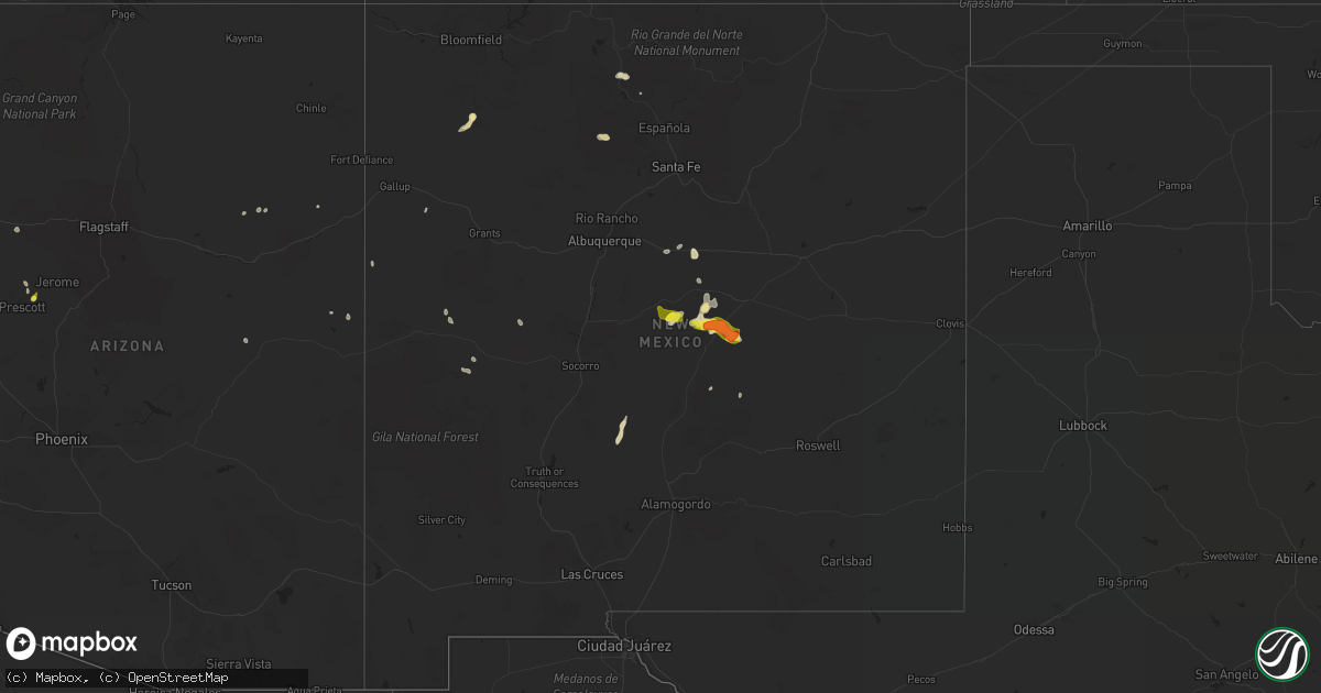
Hail Map in New Mexico on July 23, 2021
Get this storm
July 23 map
$229
one time, instant access
Download today. No call, no setup
Keep the $229
Bought the map and want the full workflow? Apply the entire $229 to a subscription within 7 days. None of it is wasted.
Every map, not just this one
This buys you this map. Subscription and you get every map we run, in the markets you choose from a few cities to whole states to nationwide. Plus real-time alerts the moment a storm fires.
Contact data
Name, contact info, occupancy, even credit band for addresses in the footprint. You go from where it hit to who to call.
Become the source they trust
Unlimited branding weather history reports on demand. You already have the documented answer ready for the property owner, and you are the one who showed up with it.
Property data and RoofTrace estimates
Pull up any address you have got, its value and the exact code rules for that jurisdiction, straight from One Click Code. Then RoofTrace estimates the squares, pitch, and roof value, priced the way you price.
Storm reports in New Mexico
New Mexico
| Date | Description |
|---|---|
| 07/23/20214:30 PM CDT | Large tree limb downed at fruit ave and luna blvd |
| 07/23/202112:33 AM CDT | At 533 PM MDT, a severe thunderstorm was located 5 miles north of Cuchillo, moving northeast at 5 mph. HAZARD...60 mph wind gusts and nickel size hail. SOURCE...Radar indicated. IMPACT...Expect damage to roofs, siding, and trees. Locations impacted include... Monticello, Cuchillo, North Monticello Point, Alamosa Canyon, Las Placitas, Lakeshore Highlands, Elephant Butte Lake and South Monticello Campground.This includes Interstate 25 in New Mexico between mile markers 81 and96. |
| 07/22/202110:56 PM CDT | At 356 PM MDT, a severe thunderstorm was located 10 miles west of La Joya, or 23 miles southwest of Belen, and is nearly stationary. HAZARD...60 mph wind gusts and half dollar size hail. SOURCE...Radar indicated. IMPACT...Hail damage to vehicles is expected. Expect wind damage to roofs, siding, and trees. This severe thunderstorm will remain over mainly rural areas of north central Socorro County. |
| 07/22/202110:26 PM CDT | At 326 PM MDT, a severe thunderstorm was located over Fairacres, moving east at 15 mph. HAZARD...60 mph wind gusts and quarter size hail. SOURCE...Radar indicated. IMPACT...Hail damage to vehicles is expected. Expect wind damage to roofs, siding, and trees. Locations impacted include... Las Cruces, Dona Ana, Mesilla, Fairacres, Picacho, Northeast Las Cruces and Mesilla Valley Bosque State Park.This includes the following highways... Interstate 10 in New Mexico between mile markers 130 and 141. Interstate 25 in New Mexico near mile marker 1, and between milemarkers 3 and 11. Highway 70 in New Mexico between mile markers 150 and 152. |
| 07/22/202110:15 PM CDT | At 314 PM MDT, a severe thunderstorm was located 7 miles south of Willard, or 18 miles south of Estancia, moving west at 25 mph. HAZARD...60 mph wind gusts and half dollar size hail. SOURCE...Radar indicated. IMPACT...Hail damage to vehicles is expected. Expect wind damage to roofs, siding, and trees. Locations impacted include... Mountainair, Willard, Torreon, Manzano Mountain State Park, Manzano and Abo.This includes Highway 60 between Mile Markers 177 and 226. |
| 07/22/202110:08 PM CDT | At 308 PM MDT, a severe thunderstorm was located 12 miles west of Nutt, moving northwest at 5 mph. HAZARD...60 mph wind gusts and quarter size hail. SOURCE...Radar indicated. IMPACT...Hail damage to vehicles is expected. Expect wind damage to roofs, siding, and trees. Locations impacted include... Cookes Peak. |
| 07/22/20219:27 PM CDT | At 227 PM MDT, a severe thunderstorm was located near Cedarvale, or 13 miles northwest of Corona, moving west at 25 mph. HAZARD...60 mph wind gusts and quarter size hail. SOURCE...Radar indicated. IMPACT...Hail damage to vehicles is expected. Expect wind damage to roofs, siding, and trees. Locations impacted include... Estancia, Willard, Corona and Cedarvale. This includes Highway 60 between Mile Markers 216 and 234. |
| 07/22/20218:45 PM CDT | At 145 PM MDT, a severe thunderstorm was located near Fenton Lake State Park, or 16 miles southeast of Cuba, moving northwest at 10 mph. HAZARD...60 mph wind gusts and half dollar size hail. SOURCE...Radar indicated. IMPACT...Hail damage to vehicles is expected. Expect wind damage to roofs, siding, and trees. Locations impacted include... Fenton Lake State Park. |
| 07/22/20218:41 PM CDT | At 140 PM MDT, a severe thunderstorm was located 12 miles northeast of Corona, moving northwest at 25 mph. HAZARD...60 mph wind gusts and half dollar size hail. SOURCE...Radar indicated. IMPACT...Hail damage to vehicles is expected. Expect wind damage to roofs, siding, and trees. Locations impacted include... Corona, Cedarvale and Duran. This includes Highway 60 between Mile Markers 242 and 243. |
| 07/22/20218:14 PM CDT | At 114 PM MDT, a severe thunderstorm was located 15 miles east of Corona, moving southwest at 10 mph. HAZARD...60 mph wind gusts and half dollar size hail. SOURCE...Radar indicated. IMPACT...Hail damage to vehicles is expected. Expect wind damage to roofs, siding, and trees. This severe thunderstorm will remain over mainly rural areas of north central Lincoln and southeastern Torrance Counties. |
All States Impacted by Hail Map on July 23, 2021
Cities Impacted by Hail Map on July 23, 2021
- Saint Johns, AZ
- Meadowlands, MN
- Floodwood, MN
- Napoleon, ND
- Stirum, ND
- Gwinner, ND
- Oakes, ND
- Socorro, NM
- Dawson, ND
- Shields, ND
- Selfridge, ND
- Solen, ND
- Madison, NH
- Silver Lake, NH
- Freedom, NH
- Cook, MN
- Pie Town, NM
- Willard, NM
- Elk River, MN
- Saint Francis, MN
- Danvers, MA
- Barnum, MN
- Holyoke, MN
- Kerrick, MN
- Orr, MN
- Tower, MN
- Mooreton, ND
- Barney, ND
- Lake Wales, FL
- Prairie City, SD
- New Leipzig, ND
- Sisseton, SD
- Moriarty, NM
- Wood Lake, NE
- Remer, MN
- Reva, SD
- Hankinson, ND
- Mantador, ND
- Tierra Amarilla, NM
- Contoocook, NH
- Harris, MN
- North Branch, MN
- Immokalee, FL
- Farmington, NM
- Solway, MN
- Bemidji, MN
- Northome, MN
- Blackduck, MN
- Kelliher, MN
- Fredonia, ND
- Mayo, FL
- Day, FL
- Wishek, ND
- Park Falls, WI
- West Bridgewater, MA
- East Bridgewater, MA
- Flasher, ND
- Squaw Lake, MN
- Mizpah, MN
- Leesburg, GA
- Smithville, GA
- Plympton, MA
- Kingston, MA
- Halifax, MA
- Ashley, ND
- Ogema, MN
- Hazelhurst, WI
- Clinton, MN
- Ortonville, MN
- Perham, MN
- Hugo, MN
- Somerset, WI
- Marine On Saint Croix, MN
- Stillwater, MN
- Magdalena, NM
- Clewiston, FL
- Detroit Lakes, MN
- Frazee, MN
- Audubon, MN
- Lake Park, MN
- Pelican Rapids, MN
- Show Low, AZ
- Littlefork, MN
- Jemez Springs, NM
- Groveland, MA
- Georgetown, MA
- Boxford, MA
- Ely, MN
- Callaway, MN
- Keldron, SD
- Lemmon, SD
- Ponemah, MN
- Bison, SD
- Wahpeton, ND
- Moffat, CO
- Stanchfield, MN
- Central, SC
- Clemson, SC
- El Rito, NM
- Beardsley, MN
- Graceville, MN
- Corrales, NM
- Nashwauk, MN
- Britton, SD
- Kintyre, ND
- Atlanta, GA
- Prescott, AZ
- Prescott Valley, AZ
- Veblen, SD
- Claire City, SD
- Winslow, AZ
- Barnesville, GA
- Milnor, ND
- Alpharetta, GA
- Claremont, SD
- Amherst, SD
- Balmorhea, TX
- West Newbury, MA
- Merrimac, MA
- Haverhill, MA
- Isanti, MN
- Cambridge, MN
- Cogswell, ND
- Park Rapids, MN
- Max, MN
- Kent, MN
- Rib Lake, WI
- Crane Lake, MN
- Rochert, MN
- Meadow, SD
- Luck, WI
- Cushing, WI
- Moorhead, MN
- Long Prairie, MN
- Lehr, ND
- Datil, NM
- Ashby, MN
- Appleton, MN
- Holloway, MN
- Hancock, MN
- International Falls, MN
- New York Mills, MN
- Vergas, MN
- Dent, MN
- Linton, ND
- East Kingston, NH
- Effingham, NH
- Ossipee, NH
- Bethel, MN
- Cedar, MN
- Leola, SD
- New Smyrna Beach, FL
- Gallup, NM
- Ash Fork, AZ
- Williams, AZ
- Akeley, MN
- Thief River Falls, MN
- Burtrum, MN
- Grey Eagle, MN
- Corona, NM
- Barnard, SD
- Kathryn, ND
- Lisbon, ND
- Jacksonville, FL
- Middleburg, FL
- Morris, MN
- Chokio, MN
- Benson, MN
- Glenwood, MN
- Murdock, MN
- Hettinger, ND
- Nevis, MN
- Wyndmere, ND
- Baileyville, ME
- Ganado, AZ
- Chino Valley, AZ
- Encino, NM
- Mcgregor, MN
- Forman, ND
- Arthur, NE
- Huron, SD
- Evansville, MN
- Summerdale, AL
- Brockton, MA
- Fence Lake, NM
- Frederick, SD
- Elbow Lake, MN
- Bunnell, FL
- Danvers, MN
- Hanson, MA
- Sargents, CO
- Cayuga, ND
- Rutland, ND
- Kingston, NH
- Newton, NH
- Bowlus, MN
- Little Falls, MN
- Wolverton, MN
- Andover, MN
- Foxhome, MN
- Campbell, MN
- Breckenridge, MN
- Danbury, WI
- Green Cove Springs, FL
- Tappen, ND
- Dry Branch, GA
- Bonaire, GA
- Warner Robins, GA
- Forbes, ND
- Rio Rancho, NM
- Grand Rapids, MN
- Inglis, FL
- Capitan, NM
- Gray, ME
- Windham, ME
- Delray Beach, FL
- Boynton Beach, FL
- Pelican Lake, WI
- Elcho, WI
- Kettle River, MN
- Moose Lake, MN
- Scandia, MN
- Swanville, MN
- Upsala, MN
- Strasburg, ND
- Isabella, MN
- Mountainair, NM
- Meredith, NH
- Moultonborough, NH
- Center Harbor, NH
- Amesbury, MA
- Exeter, NH
- Byfield, MA
- Concord, NH
- Aberdeen, SD
- Roscoe, SD
- Hosmer, SD
- Westport, SD
- Kulm, ND
- Long Lake, SD
- Columbia, SD
- Eureka, SD
- Hecla, SD
- Zeeland, ND
- Ipswich, SD
- Fullerton, ND
- Hague, ND
- Ellendale, ND
- Edgeley, ND
- Lake City, SD
- Peever, SD
- Browns Valley, MN
- New Effington, SD
- Norcross, MN
- Rosholt, SD
- Wheaton, MN
- Fergus Falls, MN
- Brookston, MN
- Saginaw, MN
- Alborn, MN
- Duluth, MN
- Superior, WI
- Cloquet, MN
- Sauk Centre, MN
- Melrose, MN


