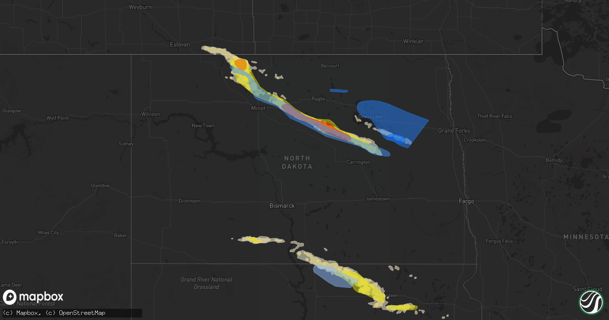
Hail Map in North Dakota on July 22, 2022
Get this storm
July 22 map
$229
one time, instant access
Download today. No call, no setup
Keep the $229
Bought the map and want the full workflow? Apply the entire $229 to a subscription within 7 days. None of it is wasted.
Every map, not just this one
This buys you this map. Subscription and you get every map we run, in the markets you choose from a few cities to whole states to nationwide. Plus real-time alerts the moment a storm fires.
Contact data
Name, contact info, occupancy, even credit band for addresses in the footprint. You go from where it hit to who to call.
Become the source they trust
Unlimited branding weather history reports on demand. You already have the documented answer ready for the property owner, and you are the one who showed up with it.
Property data and RoofTrace estimates
Pull up any address you have got, its value and the exact code rules for that jurisdiction, straight from One Click Code. Then RoofTrace estimates the squares, pitch, and roof value, priced the way you price.
Storm reports in North Dakota
North Dakota
| Date | Description |
|---|---|
| 07/22/20226:52 AM CDT | At 1151 PM CDT, severe thunderstorms were located along a line extending from near Adams to near Lakota, moving east at 40 mph. At 1145 PM CDT, HAZARD...70 mph wind gusts and quarter size hail. SOURCE...Radar indicated. IMPACT...Hail damage to vehicles is expected. Expect considerable tree damage. Wind damage is also likely to mobile homes, roofs, and outbuildings. Severe thunderstorms will be near... Adams around 1155 PM CDT. Edinburg around 1200 AM CDT. Petersburg and Park River around 1210 AM CDT.Other locations in the path of these severe thunderstorms includeHoople, Mandt and Niagara.This includes Interstate 29 between mile markers 176 and 184. |
| 07/22/20226:14 AM CDT | At 1113 PM CDT, a severe thunderstorm was located 7 miles northeast of Bremen, or 27 miles southwest of Devils Lake, moving east at 45 mph. HAZARD...70 mph wind gusts and ping pong ball size hail. SOURCE...Radar indicated. IMPACT...People and animals outdoors will be injured. Expect hail damage to roofs, siding, windows, and vehicles. Expect considerable tree damage. Wind damage is also likely to mobile homes, roofs, and outbuildings. This severe thunderstorm will be near... Oberon around 1120 PM CDT. Sheyenne around 1125 PM CDT.Other locations in the path of this severe thunderstorm includeWarwick and Hamar. |
| 07/22/20226:03 AM CDT | At 1102 PM CDT, severe thunderstorms were located along a line extending from near Vang to Oberon, moving southeast at 55 mph. At 1100 PM CDT, a mesonet reported a 62 mph wind gust near Maddock. HAZARD...70 mph wind gusts and quarter size hail. SOURCE...Radar indicated. IMPACT...Hail damage to vehicles is expected. Expect considerable tree damage. Wind damage is also likely to mobile homes, roofs, and outbuildings. Severe thunderstorms will be near... Vang around 1105 PM CDT. Olga and Fort Totten around 1110 PM CDT. Concrete and Tokio around 1120 PM CDT.Other locations in the path of these severe thunderstorms includeMountain, Akra and Warwick. |
| 07/22/20225:39 AM CDT | At 1038 PM CDT, a severe thunderstorm was located 7 miles northeast of Harvey, moving southeast at 35 mph. HAZARD...70 mph wind gusts and ping pong ball size hail. SOURCE...Radar indicated. IMPACT...People and animals outdoors will be injured. Expect hail damage to roofs, siding, windows, and vehicles. Expect considerable tree damage. Wind damage is also likely to mobile homes, roofs, and outbuildings. This severe thunderstorm will remain over mainly rural areas of northern Wells and southwestern Pierce Counties, including the following locations... Manfred, Silva, Emrick, Bremen, Selz, Hamberg, Heimdal and Wellsburg. |
| 07/22/20225:33 AM CDT | At 1033 PM CDT, a severe thunderstorm was located 8 miles west of Esmond, or 50 miles west of Devils Lake, moving east at 45 mph. HAZARD...70 mph wind gusts and ping pong ball size hail. SOURCE...Radar indicated. IMPACT...People and animals outdoors will be injured. Expect hail damage to roofs, siding, windows, and vehicles. Expect considerable tree damage. Wind damage is also likely to mobile homes, roofs, and outbuildings. This severe thunderstorm will be near... Esmond around 1045 PM CDT.Other locations in the path of this severe thunderstorm includeMaddock, Flora and Oberon. |
| 07/22/20225:19 AM CDT | At 1018 PM CDT, severe thunderstorms were located along a line extending from near Rolla to 7 miles northeast of Knox to 6 miles northwest of Fillmore, moving east at 45 mph. HAZARD...60 mph wind gusts and quarter size hail. SOURCE...Radar indicated. IMPACT...Hail damage to vehicles is expected. Expect wind damage to roofs, siding, and trees. Severe thunderstorms will be near... Leeds around 1030 PM CDT. Baker, Perth and York around 1035 PM CDT.Other locations in the path of these severe thunderstorms includeHarlow, Maza, Rocklake, Churchs Ferry, Brinsmade and Egeland. |
| 07/22/20224:42 AM CDT | At 942 PM CDT, severe thunderstorms were located along a line extending from near International Peace Garden to 5 miles southwest of Denbigh to 6 miles northeast of Velva, moving southeast at 35 mph. HAZARD...Golf ball size hail and 70 mph wind gusts. SOURCE...Radar indicated. IMPACT...People and animals outdoors will be injured. Expect hail damage to roofs, siding, windows, and vehicles. Expect considerable tree damage. Wind damage is also likely to mobile homes, roofs, and outbuildings. Severe thunderstorms will be near... International Peace Garden around 950 PM CDT.Other locations in the path of these severe thunderstorms include St.John, Belcourt, Rolla, Drake, Anamoose and Balta. |
| 07/22/20223:49 AM CDT | At 849 PM CDT, severe thunderstorms were located along a line extending from near Antler to 6 miles north of Lansford to 6 miles northeast of Carpio, moving east at 35 mph. HAZARD...Two inch hail and 70 mph wind gusts. SOURCE...Radar indicated. IMPACT...People and animals outdoors will be injured. Expect hail damage to roofs, siding, windows, and vehicles. Expect considerable tree damage. Wind damage is also likely to mobile homes, roofs, and outbuildings. Severe thunderstorms will be near... Antler around 855 PM CDT. Westhope and Maxbass around 905 PM CDT.Other locations in the path of these severe thunderstorms includeGlenburn, Newburg, Deering, Souris and Lake Metigoshe State Park. |
| 07/22/20223:36 AM CDT | Delayed report. Hail covered ground and damaged plants around house. Non-severe wind. Duration was 7 minutes. Radar estimated time. |
| 07/22/20223:34 AM CDT | At 834 PM CDT, a severe thunderstorm was located 5 miles southeast of Greene, or 11 miles southwest of Mohall, moving east at 45 mph. HAZARD...Golf ball size hail and 70 mph wind gusts. SOURCE...Radar indicated. IMPACT...People and animals outdoors will be injured. Expect hail damage to roofs, siding, windows, and vehicles. Expect considerable tree damage. Wind damage is also likely to mobile homes, roofs, and outbuildings. This severe thunderstorm will remain over mainly rural areas of northwestern Ward and southwestern Renville Counties, including the following locations... Grano. |
| 07/22/20222:54 AM CDT | At 754 PM CDT, a severe thunderstorm was located 15 miles west of Sherwood, or 19 miles northeast of Bowbells, moving east at 30 mph. HAZARD...Ping pong ball size hail and 60 mph wind gusts. SOURCE...Radar indicated. IMPACT...People and animals outdoors will be injured. Expect hail damage to roofs, siding, windows, and vehicles. Expect wind damage to roofs, siding, and trees. Locations impacted include... Sherwood and Mohall. |
| 07/22/20221:06 AM CDT | A local report indicates 61 MPH wind near 5 W GRAND FORKS |
| 07/22/20221:05 AM CDT | Measured at dot station. |
| 07/22/20221:04 AM CDT | Tree down in manvel. Report via social media. Time estimated from radar. |
| 07/22/202212:57 AM CDT | Several trees downed and damaged as well as damage to fences... A garage... And small outdoor buildings in grand forks. Report via social media. Time estimated from rad |
| 07/22/202212:51 AM CDT | Several trees down in reynolds. Report via social media. Time estimated from radar. |
| 07/22/202212:51 AM CDT | Off duty nws employee reported lamp post down. Time estimated from radar. |
| 07/22/202212:51 AM CDT | Ndawn reports a gust of 70 mph at 10 meters. |
| 07/22/202212:50 AM CDT | Off duty nws employee reported sections of fence down. Time estimated from radar. |
| 07/22/202212:48 AM CDT | Report from mping: 1-inch tree limbs broken; shingles blown off. |
| 07/22/202212:47 AM CDT | Tree down in 8 miles south of emerado. Report via social media. Time estimated from radar. |
| 07/22/202212:47 AM CDT | Numerous large trees downed and damaged... Along with damage to outdoor sheds... Furniture... Fences... And trampolines in thompson. Power outages reported. Report via |
| 07/22/202212:47 AM CDT | Three downed trees. |
| 07/22/202212:47 AM CDT | 250 to 300 foot swath of large... Old growth trees in shelter belt ripped apart. Large 6-12 inch diameter trees ripped. Sent deer running into the storm. |
| 07/22/202212:45 AM CDT | A local report indicates 66 MPH wind near 2 S EMERADO |
| 07/22/202212:45 AM CDT | Report from mping: 3-inch tree limbs broken; power poles broken. |
| 07/22/202212:44 AM CDT | Report from mping: quarter |
| 07/22/202212:43 AM CDT | Personal weather station report. |
| 07/22/202212:40 AM CDT | Damage to roof with trees down and small greenhouse destroyed. Report via social media. Time estimated from radar. |
| 07/22/202212:30 AM CDT | Numerous trees down in larimore. Report via social media. Time estimated from radar. |
| 07/22/202212:30 AM CDT | Measured at personal weather station. |
| 07/22/202212:27 AM CDT | Several trees down around northwood. Report via social media. Time estimated from radar. |
| 07/22/202212:26 AM CDT | Ndawn report. |
| 07/22/202212:24 AM CDT | Personal weather station measured 65 mph wind gust at 12:24 pm cdt. |
| 07/22/202212:18 AM CDT | Ndawn reports 65 mph at 10 meters. |
| 07/22/202212:14 AM CDT | Personal weather station report. |
| 07/22/202212:01 AM CDT | Personal weather station reports 58 mph. |
| 07/21/202211:48 PM CDT | Gust at 10 meters courtesy of ndawn. |
| 07/21/202211:45 PM CDT | Ndawn report. |
| 07/21/202211:43 PM CDT | Large section of roof torn off of metal barn. Report via social media. Time estimated from radar. |
| 07/21/202211:29 PM CDT | Report from the devils lake rwis. |
| 07/21/202211:25 PM CDT | Tree down in warick. Report via social media. Time estimated from radar. |
| 07/21/202211:24 PM CDT | Personal weather station measured 65 mph wind gust at 11:24 pm cdt. |
| 07/21/202211:19 PM CDT | Devils lake awos reports 61 mph. |
| 07/21/202211:16 PM CDT | Large treed down in frison addition south of devils lake. Report via social media. Time estimated from radar. |
| 07/21/202211:15 PM CDT | Extensive crop damage from wind driven hail reported extending from around 12 miles south of maddock to near 8 miles west southwest of sheyenne. Personal weather statio |
| 07/21/202211:10 PM CDT | Delayed report. Personal weather station. |
| 07/21/202211:05 PM CDT | Personal weather station. Extensive crop damage from wind driven hail. |
| 07/21/202211:04 PM CDT | Ndawn station reports 60 mph wind gust. |
| 07/21/202211:03 PM CDT | Us air force weather station. |
| 07/21/202210:45 PM CDT | Trees down in leeds. Report via social media. Time estimated from radar and nearby wind sensor.. |
| 07/21/202210:45 PM CDT | Ndawn reports 62 mph gust at 10 meters. |
| 07/21/202210:42 PM CDT | Ndawn niles station reports 79 mph gust at 10 meters. |
| 07/21/202210:40 PM CDT | Delayed report. Strong wind as well but no damage visible this morning. Duration was 5 approximately minutes. |
| 07/21/202210:39 PM CDT | Delayed report. Dime size hail and severe wind gusts produced soybean crop damage. |
| 07/21/202210:31 PM CDT | Multiple trees down in york. Report via social media. Time estimated from radar. |
| 07/21/202210:15 PM CDT | From ndawn site. |
| 07/21/202210:15 PM CDT | Loss of power. |
| 07/21/202210:15 PM CDT | From ndawn site. |
| 07/21/202210:15 PM CDT | A local report indicates 1.50 inch wind near 6 SW ORRIN |
| 07/21/202210:05 PM CDT | Delayed report. Nd dot site rugby us-2 mp 207. |
| 07/21/20229:51 PM CDT | Ndawn site reported wind gust. |
| 07/21/20229:45 PM CDT | A local report indicates 1.25 inch wind near 2 NNE GRANVILLE |
| 07/21/20229:06 PM CDT | Pea sized hail also reported. |
| 07/21/20229:00 PM CDT | A local report indicates 1.00 inch wind near 1 E MINOT AIR FORCE BAS |
| 07/21/20229:00 PM CDT | Facebook report of tree and roof damage at the minot air force base. |
| 07/21/20228:59 PM CDT | Minot afb. |
| 07/21/20228:59 PM CDT | Dime sized hail also reported. |
| 07/21/20228:38 PM CDT | Quarter sized hail was also reported. |
| 07/21/20228:30 PM CDT | Facebook report of a damaged quonset farm building. |
| 07/21/20228:29 PM CDT | Corrects previous tstm wnd gst report from 4 w mohall. Us air force weather station. |
| 07/21/20228:27 PM CDT | A local report indicates 1.50 inch wind near 5 SW LORAINE |
| 07/21/20228:18 PM CDT | A local report indicates 62 MPH wind near 7 N TOLLEY |
| 07/21/20228:09 PM CDT | A local report indicates 1.00 inch wind near 7 N TOLLEY |
All States Impacted by Hail Map on July 22, 2022
Cities Impacted by Hail Map on July 22, 2022
- Franklin Grove, IL
- Kamrar, IA
- Newburg, ND
- Bristol, IN
- Elkhart, IN
- South Bend, IN
- Lakeville, IN
- Osceola, IN
- Columbia City, IN
- Kimmell, IN
- Cromwell, IN
- Goshen, IN
- Mishawaka, IN
- Ligonier, IN
- Galien, MI
- Nappanee, IN
- Syracuse, IN
- New Paris, IN
- Wakarusa, IN
- New Carlisle, IN
- Albion, IN
- Bremen, IN
- Rockford, IL
- Pecatonica, IL
- Winnebago, IL
- Blairsburg, IA
- Webster City, IA
- Dundee, NY
- Rock Stream, NY
- Wolcottville, IN
- Hudson, IN
- Bartley, NE
- Sobieski, WI
- Shawano, WI
- Krakow, WI
- Little Suamico, WI
- Cecil, WI
- Abrams, WI
- Oconto Falls, WI
- Green Valley, WI
- Gillett, WI
- Upham, ND
- Kramer, ND
- Morrison, IL
- Fulton, IL
- Milledgeville, IL
- Polo, IL
- Sterling, IL
- Mount Carroll, IL
- Chadwick, IL
- Thomson, IL
- Dixon, IL
- Woosung, IL
- Delhi, LA
- Kingston, GA
- Howe, IN
- Orland, IN
- Rattan, OK
- Snow, OK
- Nashoba, OK
- Cortland, NY
- McGraw, NY
- Truxton, NY
- Decaturville, TN
- Linden, TN
- Palos Heights, IL
- Palos Park, IL
- South Haven, MI
- Frederick, SD
- Wausau, WI
- Merrill, WI
- Argos, IN
- Culver, IN
- Kouts, IN
- Senoia, GA
- Tatum, NM
- Hanover, NM
- Minot Afb, ND
- Tolley, ND
- Berthold, ND
- Mohall, ND
- Kenmare, ND
- Maxbass, ND
- Sherwood, ND
- Glenburn, ND
- Donnybrook, ND
- Carpio, ND
- Lansford, ND
- Benton, WI
- Cuba City, WI
- Shullsburg, WI
- Hazel Green, WI
- Gratiot, WI
- Darlington, WI
- Burlington, WI
- Saint Michael, ND
- Warwick, ND
- Bantry, ND
- Granville, ND
- Colesburg, IA
- Greeley, IA
- Earlville, IA
- Florence, SD
- Milton, WI
- Edgerton, WI
- Janesville, WI
- Suring, WI
- Strasburg, ND
- Zeeland, ND
- Stratford, SD
- Mansfield, SD
- Ipswich, SD
- Pollock, SD
- Hague, ND
- Aberdeen, SD
- Andover, SD
- Westport, SD
- Groton, SD
- Leola, SD
- Hosmer, SD
- Ashley, ND
- Brentford, SD
- Herreid, SD
- Conde, SD
- Mellette, SD
- Warner, SD
- Long Lake, SD
- Eureka, SD
- Bennettsville, SC
- Winnsboro, LA
- Willcox, AZ
- Center Junction, IA
- Freeport, IL
- Coggon, IA
- Hanover, IL
- Anamosa, IA
- Stockton, IL
- Hopkinton, IA
- Kent, IL
- Galena, IL
- Savanna, IL
- Monticello, IA
- Bellevue, IA
- Scales Mound, IL
- Onslow, IA
- Cascade, IA
- Delhi, IA
- Lanark, IL
- Maquoketa, IA
- Bernard, IA
- La Motte, IA
- Zwingle, IA
- Central City, IA
- Ryan, IA
- Langworthy, IA
- Lena, IL
- Pearl City, IL
- Worthington, IA
- Elizabeth, IL
- Beloit, WI
- Edwardsburg, MI
- Lansing, IL
- Thornton, IL
- Chicago Heights, IL
- Glenwood, IL
- Munster, IN
- Etna Green, IN
- Cogan Station, PA
- Trout Run, PA
- Hill City, KS
- Morland, KS
- Jesup, GA
- Odum, GA
- Deering, ND
- Amherst, SD
- Burbank, IL
- Chicago Ridge, IL
- Worth, IL
- Oak Lawn, IL
- Alsip, IL
- Bridgeview, IL
- Elgin, ND
- New Leipzig, ND
- Interlaken, NY
- Trumansburg, NY
- King Ferry, NY
- Moravia, NY
- Lansing, NY
- Lodi, NY
- Genoa, NY
- Locke, NY
- Manchester, IA
- Bronson, MI
- Elgin, IL
- Hampshire, IL
- Saint Charles, IL
- Maple Park, IL
- Patrick, SC
- Cheraw, SC
- Bristol, SD
- Elida, NM
- Chicago, IL
- Caledonia, IL
- Balfour, ND
- Oberon, ND
- Maddock, ND
- Norwich, ND
- Rugby, ND
- New Rockford, ND
- Mchenry, ND
- Harvey, ND
- Towner, ND
- Esmond, ND
- Grace City, ND
- Karlsruhe, ND
- Surrey, ND
- Glenfield, ND
- Anamoose, ND
- Drake, ND
- Sheyenne, ND
- Fort Yates, ND
- Linton, ND
- Antler, ND
- Niles, MI
- Big Rock, IL
- Delavan, WI
- Whitewater, WI
- Allen, OK
- Atwood, OK
- Homewood, IL
- Tahoka, TX
- Sabula, IA
- Bastrop, LA
- Pleasant Lake, IN
- Ashley, IN
- Hamilton, IN
- Angola, IN
- Waterloo, IN
- Butler, IN
- Manteno, IL
- Bourbonnais, IL
- Lebanon, NE
- Andrews, SC
- Georgetown, SC
- Butler, GA
- Levant, KS
- Colby, KS
- Tallulah, LA
- Plymouth, IN
- Wilburton, OK
- Hays, KS
- Mauk, GA
- Animas, NM
- Cartersville, GA
- Hiram, GA
- Douglasville, GA
- Shelton, NE
- Olivehill, TN
- Clifton, TN
- Savannah, TN
- Belvidere, IL
- Punta Gorda, FL
- Racine, WI
- Franksville, WI
- Bylas, AZ
- Penokee, KS
- Lovelady, TX
- Crockett, TX
- Woodbury, GA
- Greenville, GA
- Middleburg, FL
- Bronson, FL
- Archer, FL
- Chiefland, FL
- Society Hill, SC
- Eagle, WI
- Palmyra, WI
- Monument, KS
- Grinnell, KS
- Oakley, KS
- Ogallah, KS
- Prague, OK
- Sparks, OK
- Solen, ND
- Le Raysville, PA
- Lake Villa, IL
- Oxford, FL
- Walnut, IL
- Traer, IA
- Marienthal, KS
- Winona, KS
- Deerfield, KS
- Leoti, KS
- Indianola, NE
- Palco, KS
- Plainville, KS
- Grovertown, IN
- Walkerton, IN
- Hamlet, IN
- Knox, IN
- Heartwell, NE
- Gibbon, NE
- Ravenna, NE
- Riverdale, NE
- Kearney, NE
- Holstein, NE
- Kenesaw, NE
- Roseland, NE
- Pleasanton, NE
- Minden, NE
- Wood River, NE
- Juniata, NE
- Pleasant Prairie, WI
- Clinton, LA
- Green Cove Springs, FL
- Herndon, KS
- Culbertson, NE
- Oberlin, KS
- Montgomery, IL
- Box Springs, GA
- Fort Benning, GA
- Aurora, IL
- Miller, NE
- Cherry Valley, IL
- Ness City, KS
- Bazine, KS
- Ellijay, GA
- Ellis, KS
- La Crosse, KS
- Levelland, TX
- San Pierre, IN
- Winamac, IN
- Medaryville, IN
- North Judson, IN
- Gilbert, LA
- Summerfield, FL
- Ocala, FL
- Alachua, FL
- Bogue, KS
- Ashkum, IL
- Hoxie, KS
- Littlefield, TX
- Center Point, IA
- Garrison, IA
- La Porte City, IA
- Vinton, IA
- Mount Auburn, IA
- Urbana, IA
- Alburnett, IA
- Monroe, LA
- Oak Ridge, LA
- Shiloh, GA
- Hamilton, GA
- Pine Mountain Valley, GA
- Brownell, KS
- Amherst, NE
- Hazard, NE
- Mason City, NE
- Oconto, NE
- Sand Springs, OK
- Waynesboro, TN
- Bonfield, IL
- Ozark, AL
- Fort Rucker, AL
- Enterprise, AL
- Garden Prairie, IL
- Morriston, FL
- Williston, FL
- White Oak, GA
- Geneseo, IL
- Osco, IL
- Cambridge, IL
- Chesterton, IN
- Union Mills, IN
- Wanatah, IN
- Beverly Shores, IN
- Westville, IN
- La Porte, IN
- Whiting, IN
- Michigan City, IN
- Hammond, IN
- East Chicago, IN
- Portage, IN
- Valparaiso, IN
- Woodston, KS
- Stockton, KS
- Kennesaw, GA
- Acworth, GA
- Oswego, IL
- Bristol, IL
- Yorkville, IL
- Plano, IL
- Sterlington, LA
- Vail, AZ
- Hanna, OK
- Dustin, OK
- Frankfort, IL
- Monee, IL
- Bristol, WI
- Kenosha, WI
- Patagonia, AZ
- Lake Village, IN
- Saint Anne, IL
- Morocco, IN
- Pembroke Township, IL
- Woodstock, IL
- Mchenry, IL
- Bovina, TX
- Farwell, TX
- Robins, IA
- Cedar Rapids, IA
- Marion, IA
- Lake Forest, IL
- Kempton, IL
- Cambridge, NE
- Holbrook, NE
- Eustis, NE
- Rayville, LA
- Romeoville, IL
- Kinta, OK
- Great Lakes, IL
- Fox Lake, IL
- Spring Grove, IL
- Vernon Hills, IL
- Wauconda, IL
- Highwood, IL
- Lake Zurich, IL
- Salem, WI
- Gurnee, IL
- Ingleside, IL
- Winthrop Harbor, IL
- Libertyville, IL
- Crystal Lake, IL
- Wonder Lake, IL
- Wadsworth, IL
- Barrington, IL
- Round Lake, IL
- Waukegan, IL
- Lake Bluff, IL
- Ringwood, IL
- North Chicago, IL
- Deerfield, IL
- Mundelein, IL
- Island Lake, IL
- Grayslake, IL
- Zion, IL
- Harvard, IL
- Cary, IL
- Marengo, IL
- Antioch, IL
- Union Grove, WI
- Highland Park, IL
- Rio Rico, AZ
- Nogales, AZ
- Preston, IA
- Spragueville, IA
- Ridott, IL
- Orangeville, IL
- Saint John, IN
- Crete, IL
- Dyer, IN
- University Park, IL
- Eufaula, AL
- Palo, IA
- Little River, SC
- Longs, SC
- Jasper, GA
- Post, TX
- Peru, IL
- Granville, IL
- Spring Valley, IL
- Atwood, KS
- Selden, KS
- Lovington, NM
- Dunnellon, FL
- Warrenville, IL
- Clarendon Hills, IL
- Plainfield, IL
- Westchester, IL
- Broadview, IL
- Wheaton, IL
- Franklin Park, IL
- Westmont, IL
- Hoffman Estates, IL
- Bensenville, IL
- Elmhurst, IL
- Itasca, IL
- Huntley, IL
- Downers Grove, IL
- Glendale Heights, IL
- Union, IL
- Hillside, IL
- Oak Brook, IL
- Lombard, IL
- Brookfield, IL
- Hines, IL
- Schiller Park, IL
- Batavia, IL
- Elburn, IL
- River Forest, IL
- Medinah, IL
- Elk Grove Village, IL
- Hinsdale, IL
- Waterman, IL
- Fox River Grove, IL
- Darien, IL
- Algonquin, IL
- La Grange Park, IL
- Rolling Meadows, IL
- Melrose Park, IL
- Riverside, IL
- Schaumburg, IL
- Forest Park, IL
- Des Plaines, IL
- Hanover Park, IL
- Lisle, IL
- Hinckley, IL
- North Aurora, IL
- La Grange, IL
- Naperville, IL
- Bartlett, IL
- Villa Park, IL
- Lemont, IL
- Lake In The Hills, IL
- Addison, IL
- Sugar Grove, IL
- Stone Park, IL
- Sandwich, IL
- Winfield, IL
- Dundee, IL
- Carol Stream, IL
- Bolingbrook, IL
- Willowbrook, IL
- Bloomingdale, IL
- Mount Prospect, IL
- Glen Ellyn, IL
- Geneva, IL
- Maywood, IL
- West Chicago, IL
- Berkeley, IL
- Roselle, IL
- Orland Park, IL
- Wood Dale, IL
- Lockport, IL
- Bellwood, IL
- Mooseheart, IL
- Woodridge, IL
- South Elgin, IL
- Homer Glen, IL
- Western Springs, IL
- Gilberts, IL
- Carpentersville, IL
- Arlington Heights, IL
- Streamwood, IL
- Somonauk, IL
- Santa Rosa, NM
- Cuervo, NM
- Colona, IL
- San Simon, AZ
- Utica, MS
- Benson, AZ
- Clayton, KS
- Dallas, GA
- Emerson, GA
- Reddick, IL
- Buckingham, IL
- Herscher, IL
- Sonoita, AZ
- Elgin, AZ
- Little Rock, SC
- Dillon, SC
- Marion, LA
- Parkersburg, WV
- Latta, SC
- Bradenton, FL
- Tolna, ND
- South Shore, SD
- Ortley, SD
- Baldwin, IA
- Monmouth, IA
- Claremont, SD
- Beecher, IL
- Walker, WV
- Petroleum, WV
- Mcville, ND
- Larwill, IN
- Pierceton, IN
- Prophetstown, IL
- East Moline, IL
- Carbon Cliff, IL
- Hillsdale, IL
- Evanston, IL
- Caledonia, WI
- Skokie, IL
- Wilmette, IL
- Silver Lake, WI
- Capron, IL
- Buffalo Grove, IL
- Wilmot, WI
- Kenilworth, IL
- Poplar Grove, IL
- Northbrook, IL
- Trevor, WI
- Twin Lakes, WI
- Glenview, IL
- Winnetka, IL
- Lincolnshire, IL
- Sturtevant, WI
- Glencoe, IL
- Union Pier, MI
- Three Oaks, MI
- New Buffalo, MI
- Glennville, GA
- Ludowici, GA
- Powder Springs, GA
- Summit, MS
- Antigo, WI
- Shields, ND
- Carson, ND
- Raleigh, ND
- Liebenthal, KS
- Interlachen, FL
- Hiawatha, IA
- Shellsburg, IA
- Toddville, IA
- Walker, IA
- Springville, IA
- Clutier, IA
- Gladbrook, IA
- Keystone, IA
- Van Horne, IA
- Toledo, IA
- Dysart, IA
- Waverly, WV
- Eau Claire, MI
- Berrien Center, MI
- Rock Falls, IL
- Tampico, IL
- North Liberty, IN
- Pekin, ND
- Crary, ND
- Aneta, ND
- Port Byron, IL
- Milford, IN
- Warsaw, IN
- Leesburg, IN
- Manhattan, IL
- Peotone, IL
- Parrish, FL
- Wimauma, FL
- Rome, PA
- Wysox, PA
- River Grove, IL
- Warren, IL
- Chebanse, IL
- Clifton, IL
- Kankakee, IL
- Selfridge, ND
- La Crosse, IN
- Williamstown, WV
- Vienna, WV
- Marietta, OH
- Jal, NM
- Sheffield, IL
- Mineral, IL
- Annawan, IL
- Wyanet, IL
- New Bedford, IL
- Jacksonville, FL
- Elkhorn, WI
- Fort Atkinson, WI
- Mukwonago, WI
- East Troy, WI
- Beaverville, IL
- Fair Oaks, IN
- Grant Park, IL
- Papineau, IL
- Cabery, IL
- Martinton, IL
- Momence, IL
- Waverly Hall, GA
- Fort McCoy, FL
- Palatka, FL
- Dalzell, SC
- Rembert, SC
- Yeso, NM
- Bishopville, SC
- Hecla, SD
- Wishek, ND
- Devils Lake, ND
- Wetumka, OK
- Chancellor, AL
- McCook, NE
- Gay, GA
- Marietta, GA
- Plains, TX
- McNeal, AZ
- New Orleans, LA
- Hanna, IN
- Kingsford Heights, IN
- Gary, IN
- Friendsville, PA
- Towanda, PA
- Wyalusing, PA
- Ulster, PA
- Warren Center, PA
- Lamar, SC
- Gainesville, FL
- Gibsonton, FL
- Ruskin, FL
- Apollo Beach, FL
- Wakeeney, KS
- Watertown, SD
- Hamer, SC
- Newnan, GA
- Lamar, OK
- New Lenox, IL
- Mokena, IL
- Joliet, IL
- Machesney Park, IL
- Loves Park, IL
- Highland, IN
- Griffith, IN
- Hebron, IN
- Demotte, IN
- Wheatfield, IN
- Park, KS
- Minot, ND
- Corunna, IN
- North Webster, IN
- Churubusco, IN
- Millersburg, IN
- Brook, IN
- Shelby, IN
- Mount Ayr, IN
- Lowell, IN
- Thayer, IN
- Remington, IN
- Wolcott, IN
- Monterey, IN
- Rensselaer, IN
- Ora, IN
- Francesville, IN
- Monon, IN
- Schneider, IN
- Goodland, IN
- Saint Petersburg, FL
- Roscoe, SD
- Binford, ND
- Fessenden, ND
- Cathay, ND
- Bisbee, ND
- Wolford, ND
- Cando, ND
- York, ND
- Mayville, ND
- Niagara, ND
- Emerado, ND
- Forest River, ND
- Red Lake Falls, MN
- Churchs Ferry, ND
- Lawton, ND
- Penn, ND
- Crookston, MN
- Reynolds, ND
- East Grand Forks, MN
- Webster, ND
- Fordville, ND
- Oklee, MN
- Plummer, MN
- Larimore, ND
- Michigan, ND
- Northwood, ND
- Fisher, MN
- Gilby, ND
- Brooks, MN
- Mcintosh, MN
- Inkster, ND
- Thompson, ND
- Sharon, ND
- Arvilla, ND
- Climax, MN
- Grand Forks, ND
- Mekinock, ND
- Grand Forks Afb, ND
- Mentor, MN
- Trail, MN
- Buxton, ND
- Erskine, MN
- Brocket, ND
- Lakota, ND
- Petersburg, ND
- Hatton, ND
- Roswell, NM
- Crest Hill, IL
- Elmwood Park, IL
- Elwood, IL


