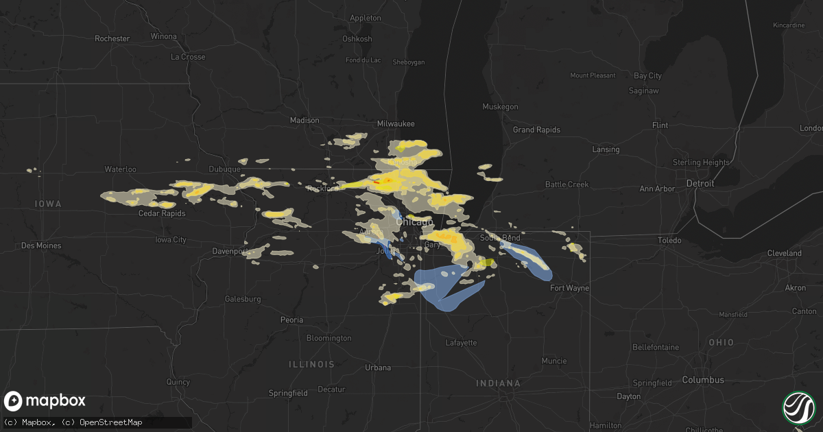
Hail Map on July 22, 2022
Get this storm
July 22 map
$229
one time, instant access
Download today. No call, no setup
Keep the $229
Bought the map and want the full workflow? Apply the entire $229 to a subscription within 7 days. None of it is wasted.
Every map, not just this one
This buys you this map. Subscription and you get every map we run, in the markets you choose from a few cities to whole states to nationwide. Plus real-time alerts the moment a storm fires.
Contact data
Name, contact info, occupancy, even credit band for addresses in the footprint. You go from where it hit to who to call.
Become the source they trust
Unlimited branding weather history reports on demand. You already have the documented answer ready for the property owner, and you are the one who showed up with it.
Property data and RoofTrace estimates
Pull up any address you have got, its value and the exact code rules for that jurisdiction, straight from One Click Code. Then RoofTrace estimates the squares, pitch, and roof value, priced the way you price.
States Impacted by Hail Map on July 22, 2022
Storm reports
Kansas
| Date | Description |
|---|---|
| 07/22/20226:57 PM CDT | A local report indicates 59 MPH wind near 12 NW SELDEN |
| 07/22/20226:45 PM CDT | From facebook: tree branches laying all over. Utility trailer picked up and dumped south of our house. Lean to building destroyed. Happened between 6:30 and 6:45 pm ct. |
| 07/22/20226:28 PM CDT | A local report indicates 61 MPH wind near 16 NNW LEOTI |
| 07/22/20225:28 PM CDT | Off-duty nws employee reported brief landspout near location. Also... Reported 2 brief and coincident landspouts in the same storm 4 minutes prior. |
| 07/22/20225:15 PM CDT | Landspout reported ese of goodland... Ks. Nws employee was on i-70 looking east southeast. |
| 07/22/20225:15 PM CDT | Corrects previous tornado report from 2 se goodland. Landspout reported ese of goodland... Ks. Nws employee was on i-70 looking east southeast. Location is approximate. |
| 07/22/20224:58 PM CDT | Corrects previous tornado report from 11 n brewster. Corrects previous tornado report from 13 ssw bird city. Landspout sighted about 10 miles east-southeast from the sh |
| 07/22/20224:58 PM CDT | Landspout sighted about 10 miles east-southeast from the sherman/cheyenne county line... North of edson... Ks. A second landspout was spotted a mile north of the first. |
| 07/22/20225:32 AM CDT | At 1031 PM CDT, a severe thunderstorm was located near Codell, or 13 miles north of Emmeram, moving east at 20 mph. HAZARD...60 mph wind gusts and nickel size hail. SOURCE...Radar indicated. IMPACT...Expect damage to roofs, siding, and trees. This severe thunderstorm will be near... Natoma around 1050 PM CDT. |
| 07/22/20225:25 AM CDT | At 1025 PM CDT, severe thunderstorms were located along a line extending from 6 miles south of Codell to near Schoenchen to 6 miles northwest of Bazine, moving southeast at 20 mph. HAZARD...60 mph wind gusts and nickel size hail. SOURCE...Radar indicated. IMPACT...Expect damage to roofs, siding, and trees. Severe thunderstorms will be near... Schoenchen, Liebenthal and Munjor around 1030 PM CDT. Loretta and Pfeifer around 1045 PM CDT.Other locations in the path of these severe thunderstorms includeAlexander, Otis and Nekoma. |
| 07/22/20225:04 AM CDT | At 1004 PM CDT, a severe thunderstorm was located 8 miles southeast of Stockton, or 26 miles north of Emmeram, moving southeast at 10 mph. HAZARD...60 mph wind gusts and quarter size hail. SOURCE...Radar indicated. IMPACT...Hail damage to vehicles is expected. Expect wind damage to roofs, siding, and trees. This severe thunderstorm will remain over mainly rural areas of southeastern Rooks County. |
| 07/22/20224:43 AM CDT | At 942 PM CDT, severe thunderstorms were located along a line extending from near Plainville to 8 miles northeast of Ogallah, moving southeast at 20 mph. HAZARD...60 mph wind gusts and quarter size hail. SOURCE...Radar indicated. IMPACT...Hail damage to vehicles is expected. Expect wind damage to roofs, siding, and trees. Severe thunderstorms will be near... Plainville around 1000 PM CDT.Other locations in the path of these severe thunderstorms includeCodell. |
| 07/22/20224:27 AM CDT | At 927 PM CDT, a severe thunderstorm was located 9 miles southwest of Palco, or 13 miles north of Ogallah, moving southeast at 20 mph. HAZARD...60 mph wind gusts and quarter size hail. SOURCE...Radar indicated. IMPACT...Hail damage to vehicles is expected. Expect wind damage to roofs, siding, and trees.PRECAUTIONARY/PREPAREDNESS ACTIONS...For your protection move to an interior room on the lowest floor of abuilding. |
| 07/22/20224:07 AM CDT | At 906 PM CDT, severe thunderstorms were located along a line extending from near Webster State Park to 7 miles south of Hill City, moving southeast at 20 mph. HAZARD...60 mph wind gusts and nickel size hail. SOURCE...Radar indicated. IMPACT...Expect damage to roofs, siding, and trees. Severe thunderstorms will be near... Damar and Webster State Park around 910 PM CDT.Other locations in the path of these severe thunderstorms includeZurich, Plainville and Codell. |
| 07/22/20224:06 AM CDT | At 906 PM CDT, a severe thunderstorm was located near Hill City, moving southeast at 30 mph. THIS IS A DESTRUCTIVE STORM FOR Southeastern Graham County. HAZARD...80 mph wind gusts and quarter size hail. SOURCE...Radar indicated. IMPACT...Flying debris will be dangerous to those caught without shelter. Mobile homes will be heavily damaged. Expect considerable damage to roofs, windows, and vehicles. Extensive tree damage and power outages are likely. This severe thunderstorm will remain over mainly rural areas of southeastern Graham County. |
| 07/22/20223:53 AM CDT | At 852 PM CDT, a severe thunderstorm was located 9 miles northeast of Scott State Lake, moving southeast at 20 mph. HAZARD...60 mph wind gusts and quarter size hail. SOURCE...Radar indicated. IMPACT...Hail damage to vehicles is expected. Expect wind damage to roofs, siding, and trees.PRECAUTIONARY/PREPAREDNESS ACTIONS...For your protection move to an interior room on the lowest floor of abuilding.Torrential rainfall is occurring with this storm, and may lead toflash flooding. Do not drive your vehicle through flooded roadways. |
| 07/22/20223:44 AM CDT | At 844 PM CDT, a severe thunderstorm was located 8 miles north of Park, or 11 miles north of Quinter, moving southeast at 20 mph. HAZARD...60 mph wind gusts and quarter size hail. SOURCE...Radar indicated. IMPACT...Hail damage to vehicles is expected. Expect wind damage to roofs, siding, and trees. This severe thunderstorm will be near... Quinter around 910 PM CDT.Other locations impacted by this severe thunderstorm include SaintPeter and Studley.This includes Interstate 70 in Kansas between mile markers 100 and113. |
| 07/22/20223:42 AM CDT | At 841 PM CDT, a severe thunderstorm was located 6 miles northeast of Morland, or 8 miles northwest of Hill City, moving southeast at 15 mph. HAZARD...70 mph wind gusts and quarter size hail. SOURCE...Radar indicated. IMPACT...Hail damage to vehicles is expected. Expect considerable tree damage. Wind damage is also likely to mobile homes, roofs, and outbuildings. Locations impacted include... Hill City and Bogue. |
| 07/22/20223:38 AM CDT | At 838 PM CDT, a severe thunderstorm was located 14 miles southwest of Modoc, moving south at 20 mph. HAZARD...60 mph wind gusts and quarter size hail. SOURCE...Radar indicated. IMPACT...Hail damage to vehicles is expected. Expect wind damage to roofs, siding, and trees. This severe thunderstorm will remain over mainly rural areas of southeastern Wichita County. |
| 07/22/20223:36 AM CDT | At 835 PM CDT, a severe thunderstorm was located 15 miles west of Friend, moving south at 15 mph. HAZARD...60 mph wind gusts and quarter size hail. SOURCE...Radar indicated. IMPACT...Hail damage to vehicles is expected. Expect wind damage to roofs, siding, and trees.PRECAUTIONARY/PREPAREDNESS ACTIONS...For your protection move to an interior room on the lowest floor of abuilding.Torrential rainfall is occurring with this storm, and may lead toflash flooding. Do not drive your vehicle through flooded roadways. |
| 07/22/20223:29 AM CDT | At 829 PM CDT, a severe thunderstorm was located 13 miles northeast of Scott State Lake, moving southeast at 25 mph. HAZARD...Ping pong ball size hail and 60 mph wind gusts. SOURCE...Radar indicated. IMPACT...People and animals outdoors will be injured. Expect hail damage to roofs, siding, windows, and vehicles. Expect wind damage to roofs, siding, and trees. This severe thunderstorm will remain over mainly rural areas of southeastern Logan and southern Gove Counties, including the following locations... The Monument Rocks. |
| 07/22/20222:56 AM CDT | At 756 PM CDT, a severe thunderstorm was located 4 miles north of Hoxie, moving southeast at 20 mph. HAZARD...70 mph wind gusts and ping pong ball size hail. SOURCE...Radar indicated. IMPACT...People and animals outdoors will be injured. Expect hail damage to roofs, siding, windows, and vehicles. Expect considerable tree damage. Wind damage is also likely to mobile homes, roofs, and outbuildings. This severe thunderstorm will remain over mainly rural areas of eastern Sheridan County, including the following locations... Tasco and Studley. |
| 07/22/20222:44 AM CDT | At 744 PM CDT, a severe thunderstorm was located 6 miles west of Modoc, moving southeast at 25 mph. HAZARD...Ping pong ball size hail and 60 mph wind gusts. SOURCE...Radar indicated. IMPACT...People and animals outdoors will be injured. Expect hail damage to roofs, siding, windows, and vehicles. Expect wind damage to roofs, siding, and trees. This severe thunderstorm will remain over mainly rural areas of southeastern Wichita County, including the following locations... Marienthal. |
| 07/22/20222:29 AM CDT | At 729 PM CDT, a severe thunderstorm was located 6 miles south of Monument, or 10 miles southwest of Oakley, moving southeast at 10 mph. HAZARD...Ping pong ball size hail and 60 mph wind gusts. SOURCE...Radar indicated. IMPACT...People and animals outdoors will be injured. Expect hail damage to roofs, siding, windows, and vehicles. Expect wind damage to roofs, siding, and trees. This severe thunderstorm will remain over mainly rural areas of northeastern Logan and northwestern Gove Counties. |
| 07/22/20222:16 AM CDT | At 716 PM CDT, a severe thunderstorm was located 7 miles northwest of Selden, or 17 miles southwest of Oberlin, moving southeast at 20 mph. HAZARD...Two inch hail and 70 mph wind gusts. SOURCE...Radar indicated. IMPACT...People and animals outdoors will be injured. Expect hail damage to roofs, siding, windows, and vehicles. Expect considerable tree damage. Wind damage is also likely to mobile homes, roofs, and outbuildings. This severe thunderstorm will be near... Selden around 735 PM CDT.Other locations impacted by this severe thunderstorm includeLeoville. |
| 07/22/20222:14 AM CDT | At 714 PM CDT, a severe thunderstorm was located 10 miles north of Leoti, moving southeast at 20 mph. HAZARD...Ping pong ball size hail and 60 mph wind gusts. SOURCE...Radar indicated. IMPACT...People and animals outdoors will be injured. Expect hail damage to roofs, siding, windows, and vehicles. Expect wind damage to roofs, siding, and trees. This severe thunderstorm will remain over mainly rural areas of northeastern Wichita County, including the following locations... Marienthal. |
| 07/22/20222:11 AM CDT | At 711 PM CDT, a severe thunderstorm was located 5 miles south of Monument, or 11 miles southwest of Oakley, moving east at 15 mph. HAZARD...Ping pong ball size hail and 60 mph wind gusts. SOURCE...Radar indicated. IMPACT...People and animals outdoors will be injured. Expect hail damage to roofs, siding, windows, and vehicles. Expect wind damage to roofs, siding, and trees. This severe thunderstorm will remain over mainly rural areas of northeastern Logan County. |
| 07/22/20221:40 AM CDT | At 640 PM CDT, a severe thunderstorm was located over Monument, or 7 miles west of Oakley, moving east at 15 mph. HAZARD...60 mph wind gusts and quarter size hail. SOURCE...Radar indicated. IMPACT...Hail damage to vehicles is expected. Expect wind damage to roofs, siding, and trees. Locations impacted include... Oakley.This includes Interstate 70 in Kansas between mile markers 71 and 79. |
| 07/22/20221:32 AM CDT | At 631 PM CDT, a severe thunderstorm was located 15 miles north of Leoti, moving east at 15 mph. HAZARD...70 mph wind gusts and nickel size hail. SOURCE...Radar indicated. At 628 PM CDT, a 61 mph wind gust was reported 16 miles NNW of Leoti, KS. IMPACT...Expect considerable tree damage. Damage is likely to mobile homes, roofs, and outbuildings. This severe thunderstorm will remain over mainly rural areas of northeastern Wichita and southwestern Logan Counties. |
| 07/22/20221:26 AM CDT | At 625 PM CDT, a severe thunderstorm was located 5 miles west of Oberlin, moving southeast at 20 mph. HAZARD...70 mph wind gusts and quarter size hail. Brief landspout tornadoes may be possible. SOURCE...Radar indicated. IMPACT...Hail damage to vehicles is expected. Expect considerable tree damage. Wind damage is also likely to mobile homes, roofs, and outbuildings. This severe thunderstorm will be near... Oberlin around 640 PM CDT. |
| 07/22/20221:00 AM CDT | At 600 PM CDT, a severe thunderstorm was located 6 miles south of Ludell, or 7 miles southeast of Atwood, moving southeast at 15 mph. HAZARD...60 mph wind gusts and quarter size hail. SOURCE...Radar indicated. IMPACT...Hail damage to vehicles is expected. Expect wind damage to roofs, siding, and trees. This severe thunderstorm will remain over mainly rural areas of east central Rawlins and west central Decatur Counties. |
| 07/22/202212:34 AM CDT | At 534 PM CDT, a severe thunderstorm was located 4 miles north of Herndon, or 16 miles northwest of Oberlin, and is nearly stationary. HAZARD...70 mph wind gusts and quarter size hail. SOURCE...Radar indicated. IMPACT...Hail damage to vehicles is expected. Expect considerable tree damage. Wind damage is also likely to mobile homes, roofs, and outbuildings. This severe thunderstorm will be near... Herndon around 610 PM CDT.Other locations impacted by this severe thunderstorm include Traer. |
| 07/21/202210:40 PM CDT | Awos station khys hays regional airport awos site. |
| 07/21/202210:29 PM CDT | Awos station khys hays regional airport awos site. |
| 07/21/20229:54 PM CDT | A local report indicates 59 MPH wind near PLAINVILLE |
| 07/21/20228:55 PM CDT | Videos sent in via social media showing multiple... Healthy tree branches broken off due to thunderstorm winds. Branches look to be about 4 inches in diameter. Time and |
| 07/21/20228:55 PM CDT | Delayed social media report with pictures of tree limbs down... The largest estimated to be about 6 inches in diameter. Time estimated from radar. |
| 07/21/20228:49 PM CDT | A local report indicates 82 MPH wind near 1 NE HILL CITY |
| 07/21/20228:46 PM CDT | Lawn furniture thrown... 6 inch tree limb damaged. Delayed report via social media. |
| 07/21/20228:46 PM CDT | Corrects previous tornado report from hill city. Delayed report via social media. Tornado... Possibly a landspout... Reported looking east from report location. Tornado |
| 07/21/20228:45 PM CDT | Delayed social media report of damage to healthy tree limb roughly 1 inch in diameter as estimated from accompanying video. |
| 07/21/20228:43 PM CDT | Delayed social media report with pictures of damage to a garage and a knocked over pull trailer. Time estimated from radar. |
| 07/21/20228:28 PM CDT | Off-duty nws employee reports at least quarter-size hail. Location estimated. |
| 07/21/20228:28 PM CDT | Corrects previous hail report from 11 nnw the monument rocks. Off-duty nws employee reports at least quarter-size hail. Location estimated. Correction: employee called |
| 07/21/20228:28 PM CDT | Corrects previous tstm wnd gst report from 11 nnw the monument rocks. Off-duty nws employee reports wind gusts of at least 70mph. Location estimated. Correction: employ |
| 07/21/20228:28 PM CDT | Off-duty nws employee reports wind gusts of at least 70mph. Location estimated. |
| 07/21/20228:14 PM CDT | A local report indicates 62 MPH wind near 5 S HOXIE |
| 07/21/20228:01 PM CDT | Kansas mesonet. 61 mph gust at 10 meter height... 45 mph gust at 2 meter height. |
| 07/21/20228:00 PM CDT | Estimated 60+ mph winds via facebook. |
| 07/21/20227:50 PM CDT | Spotter estimated wind gusts ranging 60-70mph. Time estimated. |
| 07/21/20227:50 PM CDT | Relayed pictures of damage to a hanger at the hoxie airport. Time estimated from radar. |
| 07/21/20227:45 PM CDT | Public report relayed through dispatch center. A tornado was reported around road w 30 n and road n 50 w. The tornado lifted at this point. |
| 07/21/20227:45 PM CDT | Delayed report from trained spotter. Time |
| 07/21/20227:39 PM CDT | Trained spotter reported hail about the size of quarters... Some were slightly larger than quarters. Winds near 50 mph were also estimated. |
| 07/21/20227:38 PM CDT | A local report indicates 70 MPH wind near 5 S SELDEN |
| 07/21/20227:35 PM CDT | Corrects previous tstm wnd gst report from 2 e leoti. Kansas mesonet. 61 mph gust at 10 meter height... 45 mph gust at 2 meter height. |
| 07/21/20227:30 PM CDT | Public report relayed through dispatch center. A tornado was reported to have started in the vicinity of road n 130 w and road w 100 n. |
| 07/21/20227:30 PM CDT | Golf ball size hail was reported to the northeast with dime size hail to the west. |
| 07/21/20227:30 PM CDT | Thomas county dispatch forwarded report of tornado e of rexford. Deputies dispatched. |
| 07/21/20227:14 PM CDT | A local report indicates 58 MPH wind near 14 SE LUDELL |
Florida
| Date | Description |
|---|---|
| 07/22/20226:38 PM CDT | Thunderstorm wind damage... Possible tornado reported. |
| 07/22/20225:10 PM CDT | Delayed report. Social media post reports one tree uprooted and another snapped in half from thunderstorm winds. Exact time and location approximated. |
| 07/22/20223:30 PM CDT | Delayed report. 911 call center reports powerlines down on sr 13 n and race track rd. |
| 07/22/20223:13 AM CDT | At 813 PM EDT, a severe thunderstorm was located near Santos, or 8 miles south of Ocala, moving northwest at 15 mph. HAZARD...60 mph wind gusts and penny size hail. SOURCE...Radar indicated. IMPACT...Expect damage to roofs, siding, and trees. Locations impacted include... Ocala, Ocala Airport, Santos, Belleview and Summerfield. |
| 07/22/20222:22 AM CDT | At 722 PM EDT, a severe thunderstorm was located near Lake Delancy, or 10 miles west of Pomona Park, moving north at 15 mph. HAZARD...60 mph wind gusts and penny size hail. SOURCE...Radar indicated. IMPACT...Expect damage to roofs, siding, and trees. This severe thunderstorm will remain over mainly rural areas of northeastern Marion and south central Putnam Counties, which includes Welaka. |
| 07/22/20221:59 AM CDT | At 659 PM EDT, a severe thunderstorm was located over Hollister, or near Interlachen, moving northeast at 20 mph. HAZARD...60 mph wind gusts and penny size hail. SOURCE...Radar indicated. IMPACT...Expect damage to roofs, siding, and trees. Locations impacted include... Interlachen, Hollister, Florahome, Carraway and Mannville. |
| 07/22/20221:51 AM CDT | At 650 PM EDT, a severe thunderstorm was located near Macdill Air Force Base, and will be near Downtown Saint Petersburg, moving northwest at 25 mph. HAZARD...60 mph wind gusts and penny size hail. SOURCE...Trained weather spotters. IMPACT...Expect damage to roofs, siding, and trees. Locations impacted include... Tampa, St. Petersburg, Pinellas Park, Seminole, Gulfport, Treasure Island, Kenneth City, South Pasadena, Madeira Beach and Bay Pines. |
| 07/22/202212:43 AM CDT | At 543 PM EDT, a severe thunderstorm was located near Sampson, or 11 miles west of Keystone Heights, moving northwest at 10 mph. HAZARD...60 mph wind gusts and penny size hail. SOURCE...Radar indicated. IMPACT...Expect damage to roofs, siding, and trees. Locations impacted include... Sampson, Waldo and Brooker. |
| 07/22/202212:19 AM CDT | At 519 PM EDT, a severe thunderstorm was located over Middleburg, moving northwest at 10 mph. HAZARD...60 mph wind gusts and penny size hail. SOURCE...Radar indicated. IMPACT...Expect damage to roofs, siding, and trees. Locations impacted include... Middleburg, Kingsley, Camp Blanding, Penney Farms and Asbury Lake. |
| 07/21/202211:19 PM CDT | At 419 PM EDT, a severe thunderstorm was located over Mandarin, moving south at 10 mph. HAZARD...60 mph wind gusts and penny size hail. SOURCE...Radar indicated. IMPACT...Expect damage to roofs, siding, and trees. Locations impacted include... Fruit Cove, Mandarin and Switzerland. |
Ohio
| Date | Description |
|---|---|
| 07/22/20222:42 PM CDT | Tree down along coffman rd. Time estimated from radar. |
| 07/21/202211:19 PM CDT | Smaller trees and branches down. Photo verified. Time estimated from radar. |
| 07/21/202211:17 PM CDT | At 417 PM EDT, a severe thunderstorm was located 8 miles southwest of Belmont, or 9 miles east of Parkersburg, moving southeast at 25 mph. HAZARD...60 mph wind gusts. SOURCE...Radar indicated. IMPACT...Expect damage to roofs, siding, and trees. Locations impacted include... Harrisville, Pennsboro, North Bend State Park, Ellenboro, Cairo, Nutter Farm, Petroleum, Schultz, Waverly, Pike, Macfarlan, Highland and Willow Island.This includes Route 50 in West Virginia between mile markers 13 and43. |
Illinois
| Date | Description |
|---|---|
| 07/22/20226:56 AM CDT | At 1156 PM CDT, a severe thunderstorm was located near Marengo, moving east at 45 mph. HAZARD...60 mph wind gusts and half dollar size hail. SOURCE...Radar indicated. IMPACT...Hail damage to vehicles is expected. Expect wind damage to roofs, siding, and trees. Locations impacted include... Crystal Lake, McHenry, Woodstock, Fox Lake, Island Lake, Marengo, Cary, Johnsburg, Lakemoor, Spring Grove, Wonder Lake, Lakewood, Pistakee Highlands, Oakwood Hills, Prairie Grove, Richmond, Port Barrington, Bull Valley, McCullom Lake and Ringwood.This includes... Mchenry County College, Mchenry County Fairgrounds,and Moraine Hills State Park. |
| 07/22/20226:00 AM CDT | Large tree limb snapped off tree. Time estimated from radar. |
| 07/22/20225:53 AM CDT | Large tree branches and tree limbs downed in romeoville. Time estimated from radar. |
| 07/22/20225:41 AM CDT | Initial nws storm survey and downstream tornadic debris signature on radar confirm a tornado in south naperville with an approximate starting point in a shopping plaza |
| 07/22/20225:32 AM CDT | A couple of tree branches about 3-6 inches in diameter were downed near the niu coop station. Time estimated based on kdkb awos peak gust. |
| 07/22/20225:17 AM CDT | Large tree limbs downed in niles. Time estimated from radar. |
| 07/22/20225:15 AM CDT | Krpj awos peak gust. |
| 07/22/20225:15 AM CDT | Several trees and 4-6 inch diameter branches downed in rochelle. Time estimated based on krpj awos peak gust. |
| 07/22/20225:05 AM CDT | Video shared on social media shows several large tree branches and tree limbs downed in ashton. Time estimated from radar. |
| 07/22/20224:21 AM CDT | Several 3 inch diameter tree limbs and one 20 foot long... 6 inch diameter tree limb downed. Time estimated from radar. |
| 07/22/20224:10 AM CDT | Spotter reported damage from wind driven hail at this location. Winds and hail combined to cause two pieces of siding to fall off... Along with damage to a window and m |
| 07/22/20224:10 AM CDT | Occurring right now. |
| 07/22/20223:38 AM CDT | Delayed report. From a personal weather station. |
| 07/22/20221:46 AM CDT | From second storm that passed through round lake. |
| 07/22/20221:45 AM CDT | Photo received via twitter. |
| 07/22/20221:23 AM CDT | Photo shared on social media showing hail approximately 1.5 inches in diameter in grayslake. Time estimated from radar. |
| 07/22/20221:22 AM CDT | Photo shared on social media showing quarter size hail in round lake beach. Time estimated from radar. |
| 07/22/20221:21 AM CDT | Photo shared on social media showing quarter size hail in round lake. Time estimated from radar. |
| 07/22/20221:20 AM CDT | Multiple reports of penny to quarter size hail in mundelein. |
| 07/22/20221:14 AM CDT | Measured size... With photo received on twitter. |
| 07/22/20221:00 AM CDT | Multiple reports of nickel to quarter size hail in mchenry. |
| 07/22/202212:59 AM CDT | Time estimated from radar. |
| 07/22/202212:28 AM CDT | Multiple reports of nickel to quarter size hail in lake villa. Time estimated from radar. |
| 07/21/202211:05 PM CDT | Photo shared on social media showing quarter size hailstone in old irving park. Several other reports of half inch to quarter size hail in the irving park and albany pa |
South Dakota
| Date | Description |
|---|---|
| 07/22/20226:15 AM CDT | A local report indicates 71 MPH wind near 7 E HOSMER |
| 07/22/20226:14 AM CDT | Twitter post. |
| 07/22/20226:05 AM CDT | A local report indicates 1.00 inch wind near 4 SE FERNEY |
| 07/22/20225:30 AM CDT | Mesonet station 50 herreid |
| 07/21/202210:25 PM CDT | At 325 AM CDT, a severe thunderstorm was located over Hetland, or 12 miles east of Lake Thompson State Recreation Area, moving southeast at 50 mph. HAZARD...Ping pong ball size hail and 60 mph wind gusts. SOURCE...Radar indicated. IMPACT...People and animals outdoors will be injured. Expect hail damage to roofs, siding, windows, and vehicles. Expect wind damage to roofs, siding, and trees. This severe thunderstorm will be near... Sinai and Oakwood State Park around 335 AM CDT. Volga, Bruce and Nunda around 340 AM CDT.Other locations in the path of this severe thunderstorm includeBrookings and Aurora. |
| 07/21/20229:57 PM CDT | At 257 AM CDT, a severe thunderstorm was located 7 miles south of Bryant, or 11 miles north of Lake Thompson State Recreation Area, moving southeast at 35 mph. HAZARD...Quarter size hail. SOURCE...Radar indicated. IMPACT...Damage to vehicles is expected. This severe thunderstorm will be near... Lake Preston around 310 AM CDT. Badger around 315 AM CDT.Other locations in the path of this severe thunderstorm includeHetland and Arlington. |
Indiana
| Date | Description |
|---|---|
| 07/22/20226:55 AM CDT | Large... 2 foot diameter branch downed. |
| 07/22/20226:45 AM CDT | Measured wind gust to 73 mph... Huge tree down... Numerous large branches down. |
| 07/22/20226:45 AM CDT | Trees uprooted and broken. Via twitter. Time estimated from radar. |
| 07/22/20226:45 AM CDT | 2 foot diameter tree down. |
| 07/22/20226:42 AM CDT | Large tree on power line. Time estimated from radar. |
| 07/22/20226:40 AM CDT | 3 large trees down. |
| 07/22/20226:38 AM CDT | Tree down on us 31. Via facebook. Time estimated from radar. |
| 07/22/20226:33 AM CDT | Trees down on michigan street between 11th and 12th roads. Time estimated by radar. |
| 07/22/20226:33 AM CDT | Trees down on 13th road west of queen road. Time estimated via radar. |
| 07/22/20226:29 AM CDT | Report from mping: quarter |
| 07/22/20226:28 AM CDT | 5 inch diameter limb approx. 20 feet long down. Several smaller branches down as well. |
| 07/22/20226:28 AM CDT | Tree down on 7th road and oak road. Time estimated via radar. |
| 07/22/20226:28 AM CDT | Tree down on 6th road and union road. Time estimated from radar. |
| 07/22/20226:26 AM CDT | Large tree limb downed in front of the historic courthouse in crown point. Time estimated from radar. |
| 07/22/20226:15 AM CDT | Widespread wind damage. |
| 07/22/20226:15 AM CDT | Report from mping: quarter |
| 07/22/20226:15 AM CDT | Very large tree uprooted onto a house. |
| 07/22/20226:05 AM CDT | Tree down on house. Via facebook. Time estimated from radar. |
| 07/22/20225:55 AM CDT | Large tree blocking ridgedale road. Via twitter. Time estimated from radar. |
| 07/22/20225:51 AM CDT | Tree down in road on e dayton street. Via twitter. Time estimated by radar. |
| 07/22/20225:47 AM CDT | Tree across ireland road and myrtle road. Via twitter. |
| 07/22/20225:40 AM CDT | Trees down on mobile homes around chapman lake. Via facebook. |
| 07/22/20225:33 AM CDT | Tree branch impaled windshield of minivan. Via twitter. |
| 07/22/20223:45 AM CDT | Report from mping: quarter |
| 07/22/20223:05 AM CDT | Quarter size hail lasted about 1 minute at story lake. |
Minnesota
| Date | Description |
|---|---|
| 07/22/20223:10 AM CDT | Photo sent in via social media showing a spruce tree approximately 18 to 22 inches in diameter that was snapped near the trunk around 3 am. This tree fell onto the roof |
| 07/22/20223:06 AM CDT | Measured by raws site. |
| 07/22/20222:48 AM CDT | Downed large branches caused structural damage northeast side of lake bemidji. Report via social media. Time estimated from radar. |
| 07/22/20221:44 AM CDT | Flag pole snapped and damage to outdoor furniture. Report via social media. |
| 07/22/20221:36 AM CDT | Measured at personal weather station. |
| 07/22/20221:25 AM CDT | Measured at dot station. |
| 07/22/20221:18 AM CDT | Measured at personal weather station. |
| 07/22/20221:15 AM CDT | A local report indicates 62 MPH wind near CROOKSTON |
| 07/22/20221:15 AM CDT | Farmstead had smaller tree branches of 4 to 6 inches broken off and the top of an evergreen tree snapped off. |
| 07/22/20221:15 AM CDT | Several large branches of up to 12 inch diameter snapped off. One tree of 12 to 18 inches in diameter snapped. One younger evergreen of approximately 10-12 inches uproo |
| 07/22/20221:14 AM CDT | Several trees downed and damaged as well as damage to a garage and outdoor recreational equipment in crookston. Report via social media. Time estimated from radar. |
| 07/21/20228:57 PM CDT | At 156 AM CDT, severe thunderstorms were located along a line extending from Tea to 6 miles west of Newton Hills State Park, moving east at 35 mph. HAZARD...Quarter size hail. SOURCE...Radar indicated. IMPACT...Damage to vehicles is expected. Severe thunderstorms will be near... Canton, Harrisburg and Newton Hills State Park around 210 AM CDT. Brandon and Fairview around 215 AM CDT.Other locations in the path of these severe thunderstorms includeHudson, Lake Alvin State Recreation Area, Rowena, Corson, RockValley, Valley Springs, Larchwood, Inwood, Sioux Center and Alvord. |
Arizona
| Date | Description |
|---|---|
| 07/22/20225:52 PM CDT | Hail reported 1in estimated still ongoing. |
| 07/21/202211:54 PM CDT | At 453 PM MST, a severe thunderstorm was located 7 miles southwest of Rio Rico, or 9 miles northwest of Nogales, moving west at 15 mph. HAZARD...60 mph wind gusts and quarter size hail. SOURCE...Radar indicated. IMPACT...Hail damage to vehicles is expected. Expect wind damage to roofs, siding, and trees. Locations impacted include... Ruby, Pena Blanca Lake and Arivaca Lake. |
| 07/21/202210:49 PM CDT | At 348 PM MST, a severe thunderstorm was located 11 miles north of Willcox, and is nearly stationary. HAZARD...60 mph wind gusts and quarter size hail. SOURCE...Radar indicated. IMPACT...Hail damage to vehicles is expected. Expect wind damage to roofs, siding, and trees. This severe thunderstorm will remain over mainly remote areas of south central Graham and north central Cochise Counties. |
| 07/21/202210:46 PM CDT | At 346 PM MST, a severe thunderstorm was located near Bisbee-Douglas Airport, or 12 miles east of Bisbee, and is nearly stationary. HAZARD...60 mph wind gusts and quarter size hail. SOURCE...Radar indicated. IMPACT...Hail damage to vehicles is expected. Expect wind damage to roofs, siding, and trees. Locations impacted include... Bisbee-Douglas Airport. |
| 07/21/202210:45 PM CDT | At 344 PM MST, a severe thunderstorm was located over Patagonia, or 18 miles northeast of Nogales, moving southwest at 15 mph. HAZARD...60 mph wind gusts and quarter size hail. SOURCE...Radar indicated. IMPACT...Hail damage to vehicles is expected. Expect wind damage to roofs, siding, and trees. Locations impacted include... Patagonia, Nogales International Airport and Patagonia Lake State Park. |
| 07/21/202210:39 PM CDT | At 339 PM MST, a severe thunderstorm was located near Vail, or 17 miles southeast of Davis-Monthan Air Force Base, moving northwest at 5 mph. HAZARD...60 mph wind gusts and quarter size hail. SOURCE...Radar indicated. IMPACT...Hail damage to vehicles is expected. Expect wind damage to roofs, siding, and trees. Locations impacted include... Vail. |
| 07/21/20229:32 PM CDT | At 232 PM MST, a severe thunderstorm was located over Elgin, or 22 miles northwest of Sierra Vista, moving northwest at 5 mph. HAZARD...60 mph wind gusts and quarter size hail. SOURCE...Radar indicated. IMPACT...Hail damage to vehicles is expected. Expect wind damage to roofs, siding, and trees. Locations impacted include... Sonoita and Elgin. |
New York
| Date | Description |
|---|---|
| 07/22/20226:41 PM CDT | Multiple reports of trees down along state route 90 in & near genoa. |
| 07/22/20226:37 PM CDT | Tree down on preston hill road. |
| 07/22/20226:27 PM CDT | A few trees down around eaton. |
| 07/22/20226:27 PM CDT | Two poles down near the intersection of county road 142 and halls corners road. |
| 07/22/20226:27 PM CDT | Tree down and blocking all lanes on ny-89. |
| 07/22/20226:27 PM CDT | Trees and limbs down on route 26. |
| 07/22/20226:27 PM CDT | Lines and a tree down on holten beach road. |
| 07/22/20226:09 PM CDT | Multiple reports of trees down in deruyter. |
| 07/22/20225:53 PM CDT | Thunderstorm winds knocked down trees on route 14a near the racetrack. |
| 07/22/20225:53 PM CDT | A tree fell on a house on hollister street. |
| 07/22/20225:46 PM CDT | Trees and wires down throughout northern portion of the county. |
| 07/22/20223:11 AM CDT | At 811 PM EDT, a severe thunderstorm was located near Otisco, or 15 miles south of Syracuse, moving northeast at 30 mph. HAZARD...60 mph wind gusts and nickel size hail. SOURCE...Radar indicated. IMPACT...Expect damage to roofs, siding, and trees. Locations impacted include... Syracuse, Manlius, Otisco, Watervale, La Fayette, Nedrow, Jamesville and Clark Reservation State Park. |
| 07/22/20222:51 AM CDT | At 751 PM EDT, severe thunderstorms were located along a line extending from near Solsville to near Brookfield, moving northeast at 35 mph. HAZARD...60 mph wind gusts and penny size hail. SOURCE...Radar indicated. IMPACT...Expect damage to roofs, siding, and trees. Locations impacted include... Brookfield, Waterville, West Winfield, Bridgewater, Clayville, Unadilla Forks, Hubbardsville, Stockwell, North Brookfield and Sauquoit. |
| 07/22/20222:35 AM CDT | At 735 PM EDT, a severe thunderstorm was located over King Ferry, or 14 miles north of Ithaca, moving east at 35 mph. HAZARD...60 mph wind gusts and nickel size hail. SOURCE...Radar indicated. IMPACT...Expect damage to roofs, siding, and trees. Locations impacted include... Homer, Locke, Genoa, Moravia, Scott, Sempronius, King Ferry, Montville, Kelloggsville and Lake Ridge. |
| 07/22/20222:21 AM CDT | At 720 PM EDT, a severe thunderstorm was located over Erieville, or 8 miles west of Hamilton, moving northeast at 30 mph. HAZARD...60 mph wind gusts and penny size hail. SOURCE...Radar indicated. IMPACT...Expect damage to roofs, siding, and trees. Locations impacted include... Kirkland, Westmoreland, Eaton, Paris, Hamilton, Morrisville, Stockbridge, Augusta, Clinton and Waterville. |
| 07/22/20221:51 AM CDT | At 651 PM EDT, a severe thunderstorm was located over Dundee, moving east at 20 mph. HAZARD...60 mph wind gusts and penny size hail. SOURCE...Radar indicated. IMPACT...Expect damage to roofs, siding, and trees. Locations impacted include... Hector, Starkey, Covert, Ledyard, Trumansburg, Dundee, Interlaken, Lodi, Caywood and Reynoldsville. |
| 07/22/20221:39 AM CDT | At 639 PM EDT, a severe thunderstorm was located over East Homer, or 7 miles northeast of Cortland, moving northeast at 30 mph. HAZARD...60 mph wind gusts and penny size hail. SOURCE...Radar indicated. IMPACT...Expect damage to roofs, siding, and trees. Locations impacted include... Cazenovia, Lebanon, Truxton, Cuyler, Georgetown, Deruyter, Fabius, Erieville, De Ruyter and East Homer. |
| 07/21/20227:55 PM CDT | Approximately 30 trees down at a residence on dairy hill rd. Time estimated from radar |
| 07/21/20227:45 PM CDT | Trees down near intersection of castle rd and state route 28 |
New Mexico
| Date | Description |
|---|---|
| 07/22/20222:59 AM CDT | At 759 PM MDT, a severe thunderstorm was located 12 miles southwest of Nutt, moving west at 10 mph. HAZARD...60 mph wind gusts and penny size hail. SOURCE...Radar indicated. IMPACT...Expect damage to roofs, siding, and trees. Locations impacted include... Cookes Peak. |
| 07/22/20221:33 AM CDT | At 633 PM MST, a severe thunderstorm was located 10 miles west of Steins, moving south at 20 mph. HAZARD...60 mph wind gusts and quarter size hail. SOURCE...Radar indicated. IMPACT...Hail damage to vehicles is expected. Expect wind damage to roofs, siding, and trees. Locations impacted include... San Simon. |
| 07/21/20229:33 PM CDT | At 233 PM MDT, a severe thunderstorm was located 12 miles northwest of Caprock, or 36 miles northwest of Tatum, moving west at 10 mph. HAZARD...60 mph wind gusts and quarter size hail. SOURCE...Radar indicated. IMPACT...Hail damage to vehicles is expected. Expect wind damage to roofs, siding, and trees. This severe thunderstorm will remain over mainly rural areas of east central Chaves County.This includes Highway 380 between Mile Markers 183 and 197. |
Georgia
| Date | Description |
|---|---|
| 07/22/20222:49 AM CDT | At 749 PM EDT, a severe thunderstorm was located over Waverly, or 9 miles north of Woodbine, moving east at 20 mph. HAZARD...60 mph wind gusts and penny size hail. SOURCE...Radar indicated. IMPACT...Expect damage to roofs, siding, and trees. Locations impacted include... Waverly and Tarboro. |
Iowa
| Date | Description |
|---|---|
| 07/22/20224:29 AM CDT | 10 to 12 inch diameter tree branch was down at this location damaging gutters at this location. Time based on radar. |
| 07/22/20224:28 AM CDT | 6 inch diameter fruit tree snapped. Time based on radar. |
| 07/22/20224:25 AM CDT | Delayed report via social media. Large tree branch down on a house. |
| 07/22/20224:21 AM CDT | Tree reported to be blown down in rock creek campground. |
| 07/22/20224:02 AM CDT | Iadot rwis. |
| 07/22/20223:07 AM CDT | A local report indicates 62 MPH wind near DUBUQUE REGIONAL ARPT |
| 07/22/20222:10 AM CDT | Delayed report via social media and time estimated from radar. 7 inch diameter maple branch down. |
| 07/21/20229:27 PM CDT | At 227 AM CDT, severe thunderstorms were located along a line extending from Sioux Center to near Remsen, moving east at 25 mph. HAZARD...Quarter size hail. SOURCE...Radar indicated. IMPACT...Damage to vehicles is expected. Severe thunderstorms will be near... Remsen around 230 AM CDT. Marcus around 240 AM CDT.Other locations in the path of these severe thunderstorms includeAlton, Cleghorn, Hospers, Quimby and Granville. |
| 07/21/20228:29 PM CDT | At 129 AM CDT, a severe thunderstorm was located near Wall Lake, or 8 miles northeast of Parker, moving east at 35 mph. HAZARD...60 mph wind gusts and quarter size hail. SOURCE...Radar indicated. IMPACT...Hail damage to vehicles is expected. Expect wind damage to roofs, siding, and trees. This severe thunderstorm will be near... Wall Lake around 135 AM CDT. Ellis around 145 AM CDT.Other locations in the path of this severe thunderstorm include SiouxFalls, Tea, Canton, Brandon, Harrisburg, Lake Alvin State RecreationArea and Rowena. |
| 07/21/20228:26 PM CDT | At 126 AM CDT, a severe thunderstorm was located near Lennox, or 14 miles north of Beresford, moving east at 35 mph. HAZARD...60 mph wind gusts and quarter size hail. SOURCE...Radar indicated. IMPACT...Hail damage to vehicles is expected. Expect wind damage to roofs, siding, and trees. This severe thunderstorm will be near... Worthing around 135 AM CDT. Harrisburg around 145 AM CDT.Other locations in the path of this severe thunderstorm includeNewton Hills State Park and Canton. |
Oklahoma
| Date | Description |
|---|---|
| 07/22/20223:45 PM CDT | Wilburton mesonet reported a 66 mph wind gust. |
| 07/22/20221:31 AM CDT | At 631 PM CDT, a severe thunderstorm was located near Prague, moving north at 15 mph. HAZARD...60 mph wind gusts and quarter size hail. SOURCE...Radar indicated. IMPACT...Hail damage to vehicles is expected. Expect wind damage to roofs, siding, and trees. Locations impacted include... Prague and Sparks. |
| 07/21/202210:38 PM CDT | At 338 PM CDT, a severe thunderstorm was located over Damon, and is nearly stationary. HAZARD...60 mph wind gusts. SOURCE...Radar indicated. IMPACT...Expect damage to roofs, siding, and trees. Locations in or near the path include... Wilburton... Damon... Panola... |
Utah
| Date | Description |
|---|---|
| 07/22/20226:45 PM CDT | Pom north side |
| 07/22/20226:40 PM CDT | Legacy parkway |
| 07/22/20226:20 PM CDT | I-80 mp 107 |
| 07/22/20226:00 PM CDT | I-80 at mp 79 - timpie |
| 07/22/20225:50 PM CDT | I-80 at mp 71 - east delle |
| 07/22/20225:40 PM CDT | I-80 at grassey |
| 07/22/20225:30 PM CDT | Johnsons pass mesonet site |
| 07/22/20225:15 PM CDT | Dugway 32 mesonet site |
| 07/22/20225:00 PM CDT | Lower cedar mountain mesonet site |
| 07/22/20225:00 PM CDT | Aerie mesonet site |
| 07/22/20224:45 PM CDT | Playa station mesonet site |
| 07/22/20224:35 PM CDT | Ottineau nd 4860 10133 pea sized hail also reported. |
| 07/22/20224:35 PM CDT | Apg mesonet site |
| 07/22/20224:30 PM CDT | Pom north side mesonet site |
| 07/22/20224:15 PM CDT | V-grid mesonet site |
| 07/22/20223:55 PM CDT | Causeway mesonet site |
| 07/22/20222:35 PM CDT | Estimate based on pictures of damage to large tree and pivot irrigation. |
| 07/22/20222:35 PM CDT | Large tree down... Roof shingles blown off... Play structures damaged and blown over... Fences damaged... House under construction damaged... Pivot line irrigation syst |
| 07/22/20222:35 PM CDT | Utility pole and large tree down... Roof shingles blown off... Play structures damaged and blown over. |
| 07/22/202212:26 AM CDT | At 525 PM MDT, severe thunderstorms were located along a line extending from 8 miles southeast of Great Salt Lake South of the Causeway to near Cedar Fort, moving east at 30 mph. HAZARD...60 mph wind gusts. SOURCE...Radar indicated. IMPACT...Expect damage to roofs, siding, and trees. Locations impacted include... Salt Lake City, West Valley City, Provo, Sandy, Ogden, Layton, Murray, Bountiful, Tooele, Farmington, Park City, Morgan, Hill Air Force Base, Heber City, West Jordan, Orem, Taylorsville, South Jordan, Lehi and Draper.This includes the following highways... Interstate 15 between mile markers 257 and 336. Interstate 84 between mile markers 85 and 109. Interstate 80 in Utah between mile markers 93 and 154. US Route 40 between mile markers 0 and 22. |
| 07/21/202211:45 PM CDT | At 444 PM MDT, severe thunderstorms were located along a line extending from 7 miles west of Delle to 7 miles west of Grantsville to near Vernon, moving east at 35 mph. HAZARD...60 mph wind gusts. SOURCE...Radar indicated. IMPACT...Expect damage to roofs, siding, and trees. Locations impacted include... Salt Lake City, West Valley City, Sandy, Murray, Tooele, Grantsville, West Jordan, Taylorsville, South Jordan, Lehi, Draper, Riverton, Midvale, South Salt Lake, Herriman, Eagle Mountain, North Salt Lake, Stansbury Park, Bluffdale and Cedar Fort.This includes the following highways... Interstate 15 between mile markers 280 and 301. Interstate 80 in Utah between mile markers 54 and 118. |
| 07/21/202211:01 PM CDT | At 401 PM MDT, severe thunderstorms were located along a line extending from 6 miles north of Utah Test and Training Range South to 14 miles west of Skull Valley to 14 miles south of Dugway English Village, moving northeast at 30 mph. HAZARD...60 mph wind gusts. SOURCE...Radar indicated. IMPACT...Expect damage to roofs, siding, and trees. Locations impacted include... Grantsville, Dugway English Village, Vernon, Dugway Proving Ground Test Range, Delle, Skull Valley, Clive, Utah Test and Training Range South, Knolls, Tooele Army Depot South, Tooele Army Depot, Rush Valley and Faust.This includes Interstate 80 in Utah between mile markers 28 and 86. |
| 07/21/202210:09 PM CDT | At 309 PM MDT, severe thunderstorms were located along a line extending from 19 miles southwest of Utah Test and Training Range South to 9 miles north of Fish Springs Wildlife Refuge, moving northeast at 20 mph. HAZARD...70 mph wind gusts. SOURCE...Radar indicated. IMPACT...Expect considerable tree damage. Damage is likely to mobile homes, roofs, and outbuildings. Locations impacted include... Dugway English Village, Dugway Proving Ground Test Range, Utah Test and Training Range South, Knolls, Skull Valley, Clive and Bonneville Salt Flats.This includes Interstate 80 in Utah between mile markers 4 and 68. |
Texas
| Date | Description |
|---|---|
| 07/22/202211:25 AM CDT | Received several photos and reports of a landspout near motiva and valero. No damage was reported. |
| 07/21/202211:44 PM CDT | At 444 PM CDT, a severe thunderstorm was located near Anton, or 9 miles southeast of Littlefield, moving southeast at 10 mph. HAZARD...60 mph wind gusts. SOURCE...Radar indicated. IMPACT...Expect damage to roofs, siding, and trees. Locations impacted include... Littlefield, Anton, Spade, Whitharral and Smyer. |
| 07/21/202210:58 PM CDT | At 357 PM CDT, a severe thunderstorm was located near Austonio, moving northwest at 10 mph. HAZARD...Quarter size hail. SOURCE...Radar indicated. IMPACT...Damage to vehicles is expected. Locations impacted include... Austonio. |
North Carolina
| Date | Description |
|---|---|
| 07/21/202211:47 PM CDT | At 446 PM EDT, a severe thunderstorm was located over Minturn, or 7 miles northwest of Dillon, moving east at 55 mph. HAZARD...60 mph wind gusts. SOURCE...Radar indicated. IMPACT...Expect wind damage to trees and power lines. Locations impacted include... Dillon, Mullins, Fairmont, Latta, Rowland, Lake View, Boardman, Fork, Zion, Hamer, Brownsville, South Of The Border, Minturn, Oak Grove, Barnesville, Bingham, Floydale, Smithboro, Kemper and Little Rock. |
Wisconsin
| Date | Description |
|---|---|
| 07/22/20226:00 AM CDT | Numerous power lines and tree branches downed with some roof damage. Most damage is between sth 11and 2700 block addresses. About a 3 block wide path from 95th street a |
Mississippi
| Date | Description |
|---|---|
| 07/22/20223:47 PM CDT | Multiple trees downed. Pea sized hail reported. |
Louisiana
| Date | Description |
|---|---|
| 07/22/20221:11 AM CDT | At 611 AM CDT, a severe thunderstorm was located over Carville, or near Plaquemine, moving west at 30 mph. HAZARD...60 mph wind gusts. SOURCE...Radar indicated. IMPACT...Expect damage to roofs, siding, and trees. Locations impacted include... Baton Rouge, Plaquemine, St. Gabriel, Addis, Brusly, White Castle, Bayou Sorrel, Gardere and Carville. |
Pennsylvania
| Date | Description |
|---|---|
| 07/22/20225:32 PM CDT | Trees down in the wysox... Ulster and standing stone areas. |
| 07/22/20223:00 PM CDT | Multiple trees down. Unknown size or number of trees. Time estimated from radar. |
| 07/22/20222:45 PM CDT | Trees down. Unknown size or number of trees. Time estimated from radar. |
| 07/22/20221:58 PM CDT | Several trees down... Tree down on a truck. |
| 07/22/20221:45 PM CDT | Trees down. Time estimated from radar. |
| 07/22/20221:04 PM CDT | Quarter sized hail in trout run. |
| 07/22/20221:45 AM CDT | At 644 PM EDT, severe thunderstorms were located along a line extending from near Rome to near Herrickville, moving northeast at 35 mph. HAZARD...60 mph wind gusts and penny size hail. SOURCE...Radar indicated. IMPACT...Expect damage to roofs, siding, and trees. Locations impacted include... Orwell, Rome, Le Raysville, Little Meadows, Friendsville, Warren Center, Vestal Center, Brackney, Herrickville and Brushville. |
| 07/21/202210:58 PM CDT | At 358 PM EDT, a severe thunderstorm was located over Lake Carey, or near Tunkhannock, moving east at 25 mph. HAZARD...60 mph wind gusts and nickel size hail. SOURCE...Radar indicated. IMPACT...Expect damage to roofs, siding, and trees. Locations impacted include... Scranton, Falls, Dunmore, Carbondale, Old Forge, Archbald, Blakely, Taylor, Dickson City and Moosic. |
West Virginia
| Date | Description |
|---|---|
| 07/22/20224:00 PM CDT | Trees down along cabin run. Time estimated from radar. |
| 07/22/20223:37 PM CDT | Trees down south of petroleum time estimated from radar. |
| 07/22/20223:27 PM CDT | Tree into power lines along windy bush rd. |
| 07/22/20222:59 PM CDT | Trees down off of route 31 east of the airport. Time estimated from radar. |
| 07/22/20222:46 PM CDT | Tree down along old saint marys pike power out in the area. |
| 07/21/202211:57 PM CDT | At 457 PM EDT, a severe thunderstorm was located 7 miles southwest of North Bend State Park, or 10 miles west of Harrisville, moving southeast at 20 mph. HAZARD...60 mph wind gusts and quarter size hail. SOURCE...Radar indicated. IMPACT...Hail damage to vehicles is expected. Expect wind damage to roofs, siding, and trees. Locations impacted include... Harrisville, Cairo, Pullman, Petroleum and Smithville. |
| 07/21/202211:04 PM CDT | At 404 PM EDT, a severe thunderstorm was located near Middlebourne, moving southeast at 25 mph. HAZARD...60 mph wind gusts. SOURCE...Radar indicated. IMPACT...Expect damage to roofs, siding, and trees. Locations impacted include... Middlebourne, West Union, Alma, Smithburg, Wick, Mountain, Lima, Blandville, Center Point, Canton and Sedalia.This includes Route 50 in West Virginia between mile markers 50 and59. |
| 07/21/202210:31 PM CDT | At 330 PM EDT, a severe thunderstorm was located near Boaz, or near Marietta, moving east at 25 mph. HAZARD...60 mph wind gusts. SOURCE...Radar indicated. IMPACT...Expect damage to roofs, siding, and trees. Locations impacted include... Marietta, St. Marys, Vienna, Williamstown, Belmont, Boaz, Newport, North Hills, Waverly, Fleming, Willow Island and Devola.This includes the following highways... Interstate 77 in West Virginia between mile markers 180 and 186. Interstate 77 in Ohio between mile markers 1 and 5. Route 50 in West Virginia between mile markers 19 and 23. |
Wyoming
| Date | Description |
|---|---|
| 07/21/20228:16 PM CDT | I-80 and us-189 - first divide |
Alabama
| Date | Description |
|---|---|
| 07/22/20226:22 PM CDT | A few trees were blown down. |
Nebraska
| Date | Description |
|---|---|
| 07/22/20226:43 AM CDT | At 1142 PM CDT, severe thunderstorms were located along a line extending from 8 miles southwest of Litchfield to near Gibbon, and are nearly stationary. HAZARD...60 mph wind gusts and quarter size hail. SOURCE...Radar indicated. IMPACT...Hail damage to vehicles is expected. Expect wind damage to roofs, siding, and trees. Locations impacted include... Pleasanton, and Hazard. |
| 07/22/20226:11 AM CDT | At 1110 PM CDT, severe thunderstorms were located along a line extending from 9 miles northeast of Miller to near Pleasanton, moving east at 5 mph. HAZARD...60 mph wind gusts and quarter size hail. SOURCE...Radar indicated. IMPACT...Hail damage to vehicles is expected. Expect wind damage to roofs, siding, and trees. Severe thunderstorms will be near... Pleasanton around 1115 PM CDT. |
| 07/22/20225:24 AM CDT | At 1024 PM CDT, a severe thunderstorm was located 8 miles northeast of Miller, or 23 miles northwest of Kearney, moving southeast at 5 mph. HAZARD...Half dollar size hail. SOURCE...Radar indicated. IMPACT...Damage to vehicles is expected. This severe thunderstorm will remain over mainly rural areas of northwestern Buffalo County. |
| 07/22/20221:44 AM CDT | Facebook report. |
| 07/22/20221:39 AM CDT | Delayed report of quarter size hail overnight...via facebook. Time estimated from radar. |
| 07/22/20221:29 AM CDT | Nebraska dot mesonet along interstate 80 at shelton exit. |
| 07/22/20221:14 AM CDT | A local report indicates 1.00 inch wind near 2 N GIBBON |
| 07/22/202212:20 AM CDT | Delayed report from overnight storms...via facebook. Time estimated from radar. Also unofficial gauge had 2.80 inches of rain. |
| 07/21/202211:52 PM CDT | At 452 PM CDT, a severe thunderstorm was located 9 miles north of Herndon, or 13 miles southeast of Trenton, moving east at 10 mph. HAZARD...70 mph wind gusts and quarter size hail. SOURCE...Radar indicated. IMPACT...Hail damage to vehicles is expected. Expect considerable tree damage. Wind damage is also likely to mobile homes, roofs, and outbuildings. This severe thunderstorm will remain over mainly rural areas of southwestern Red Willow and southeastern Hitchcock Counties. |
| 07/21/202210:34 PM CDT | Delayed report. Facebook photo of large hail estimated to be just shy of hen egg size. Location estimated based on description of 13 s of mason city. Time estimated fro |
North Dakota
| Date | Description |
|---|---|
| 07/22/20226:52 AM CDT | At 1151 PM CDT, severe thunderstorms were located along a line extending from near Adams to near Lakota, moving east at 40 mph. At 1145 PM CDT, HAZARD...70 mph wind gusts and quarter size hail. SOURCE...Radar indicated. IMPACT...Hail damage to vehicles is expected. Expect considerable tree damage. Wind damage is also likely to mobile homes, roofs, and outbuildings. Severe thunderstorms will be near... Adams around 1155 PM CDT. Edinburg around 1200 AM CDT. Petersburg and Park River around 1210 AM CDT.Other locations in the path of these severe thunderstorms includeHoople, Mandt and Niagara.This includes Interstate 29 between mile markers 176 and 184. |
| 07/22/20226:14 AM CDT | At 1113 PM CDT, a severe thunderstorm was located 7 miles northeast of Bremen, or 27 miles southwest of Devils Lake, moving east at 45 mph. HAZARD...70 mph wind gusts and ping pong ball size hail. SOURCE...Radar indicated. IMPACT...People and animals outdoors will be injured. Expect hail damage to roofs, siding, windows, and vehicles. Expect considerable tree damage. Wind damage is also likely to mobile homes, roofs, and outbuildings. This severe thunderstorm will be near... Oberon around 1120 PM CDT. Sheyenne around 1125 PM CDT.Other locations in the path of this severe thunderstorm includeWarwick and Hamar. |
| 07/22/20226:03 AM CDT | At 1102 PM CDT, severe thunderstorms were located along a line extending from near Vang to Oberon, moving southeast at 55 mph. At 1100 PM CDT, a mesonet reported a 62 mph wind gust near Maddock. HAZARD...70 mph wind gusts and quarter size hail. SOURCE...Radar indicated. IMPACT...Hail damage to vehicles is expected. Expect considerable tree damage. Wind damage is also likely to mobile homes, roofs, and outbuildings. Severe thunderstorms will be near... Vang around 1105 PM CDT. Olga and Fort Totten around 1110 PM CDT. Concrete and Tokio around 1120 PM CDT.Other locations in the path of these severe thunderstorms includeMountain, Akra and Warwick. |
| 07/22/20225:39 AM CDT | At 1038 PM CDT, a severe thunderstorm was located 7 miles northeast of Harvey, moving southeast at 35 mph. HAZARD...70 mph wind gusts and ping pong ball size hail. SOURCE...Radar indicated. IMPACT...People and animals outdoors will be injured. Expect hail damage to roofs, siding, windows, and vehicles. Expect considerable tree damage. Wind damage is also likely to mobile homes, roofs, and outbuildings. This severe thunderstorm will remain over mainly rural areas of northern Wells and southwestern Pierce Counties, including the following locations... Manfred, Silva, Emrick, Bremen, Selz, Hamberg, Heimdal and Wellsburg. |
| 07/22/20225:33 AM CDT | At 1033 PM CDT, a severe thunderstorm was located 8 miles west of Esmond, or 50 miles west of Devils Lake, moving east at 45 mph. HAZARD...70 mph wind gusts and ping pong ball size hail. SOURCE...Radar indicated. IMPACT...People and animals outdoors will be injured. Expect hail damage to roofs, siding, windows, and vehicles. Expect considerable tree damage. Wind damage is also likely to mobile homes, roofs, and outbuildings. This severe thunderstorm will be near... Esmond around 1045 PM CDT.Other locations in the path of this severe thunderstorm includeMaddock, Flora and Oberon. |
| 07/22/20225:19 AM CDT | At 1018 PM CDT, severe thunderstorms were located along a line extending from near Rolla to 7 miles northeast of Knox to 6 miles northwest of Fillmore, moving east at 45 mph. HAZARD...60 mph wind gusts and quarter size hail. SOURCE...Radar indicated. IMPACT...Hail damage to vehicles is expected. Expect wind damage to roofs, siding, and trees. Severe thunderstorms will be near... Leeds around 1030 PM CDT. Baker, Perth and York around 1035 PM CDT.Other locations in the path of these severe thunderstorms includeHarlow, Maza, Rocklake, Churchs Ferry, Brinsmade and Egeland. |
| 07/22/20224:42 AM CDT | At 942 PM CDT, severe thunderstorms were located along a line extending from near International Peace Garden to 5 miles southwest of Denbigh to 6 miles northeast of Velva, moving southeast at 35 mph. HAZARD...Golf ball size hail and 70 mph wind gusts. SOURCE...Radar indicated. IMPACT...People and animals outdoors will be injured. Expect hail damage to roofs, siding, windows, and vehicles. Expect considerable tree damage. Wind damage is also likely to mobile homes, roofs, and outbuildings. Severe thunderstorms will be near... International Peace Garden around 950 PM CDT.Other locations in the path of these severe thunderstorms include St.John, Belcourt, Rolla, Drake, Anamoose and Balta. |
| 07/22/20223:49 AM CDT | At 849 PM CDT, severe thunderstorms were located along a line extending from near Antler to 6 miles north of Lansford to 6 miles northeast of Carpio, moving east at 35 mph. HAZARD...Two inch hail and 70 mph wind gusts. SOURCE...Radar indicated. IMPACT...People and animals outdoors will be injured. Expect hail damage to roofs, siding, windows, and vehicles. Expect considerable tree damage. Wind damage is also likely to mobile homes, roofs, and outbuildings. Severe thunderstorms will be near... Antler around 855 PM CDT. Westhope and Maxbass around 905 PM CDT.Other locations in the path of these severe thunderstorms includeGlenburn, Newburg, Deering, Souris and Lake Metigoshe State Park. |
| 07/22/20223:36 AM CDT | Delayed report. Hail covered ground and damaged plants around house. Non-severe wind. Duration was 7 minutes. Radar estimated time. |
| 07/22/20223:34 AM CDT | At 834 PM CDT, a severe thunderstorm was located 5 miles southeast of Greene, or 11 miles southwest of Mohall, moving east at 45 mph. HAZARD...Golf ball size hail and 70 mph wind gusts. SOURCE...Radar indicated. IMPACT...People and animals outdoors will be injured. Expect hail damage to roofs, siding, windows, and vehicles. Expect considerable tree damage. Wind damage is also likely to mobile homes, roofs, and outbuildings. This severe thunderstorm will remain over mainly rural areas of northwestern Ward and southwestern Renville Counties, including the following locations... Grano. |
| 07/22/20222:54 AM CDT | At 754 PM CDT, a severe thunderstorm was located 15 miles west of Sherwood, or 19 miles northeast of Bowbells, moving east at 30 mph. HAZARD...Ping pong ball size hail and 60 mph wind gusts. SOURCE...Radar indicated. IMPACT...People and animals outdoors will be injured. Expect hail damage to roofs, siding, windows, and vehicles. Expect wind damage to roofs, siding, and trees. Locations impacted include... Sherwood and Mohall. |
| 07/22/20221:06 AM CDT | A local report indicates 61 MPH wind near 5 W GRAND FORKS |
| 07/22/20221:05 AM CDT | Measured at dot station. |
| 07/22/20221:04 AM CDT | Tree down in manvel. Report via social media. Time estimated from radar. |
| 07/22/202212:57 AM CDT | Several trees downed and damaged as well as damage to fences... A garage... And small outdoor buildings in grand forks. Report via social media. Time estimated from rad |
| 07/22/202212:51 AM CDT | Ndawn reports a gust of 70 mph at 10 meters. |
| 07/22/202212:51 AM CDT | Several trees down in reynolds. Report via social media. Time estimated from radar. |
| 07/22/202212:51 AM CDT | Off duty nws employee reported lamp post down. Time estimated from radar. |
| 07/22/202212:50 AM CDT | Off duty nws employee reported sections of fence down. Time estimated from radar. |
| 07/22/202212:48 AM CDT | Report from mping: 1-inch tree limbs broken; shingles blown off. |
| 07/22/202212:47 AM CDT | 250 to 300 foot swath of large... Old growth trees in shelter belt ripped apart. Large 6-12 inch diameter trees ripped. Sent deer running into the storm. |
| 07/22/202212:47 AM CDT | Numerous large trees downed and damaged... Along with damage to outdoor sheds... Furniture... Fences... And trampolines in thompson. Power outages reported. Report via |
| 07/22/202212:47 AM CDT | Three downed trees. |
| 07/22/202212:47 AM CDT | Tree down in 8 miles south of emerado. Report via social media. Time estimated from radar. |
| 07/22/202212:45 AM CDT | Report from mping: 3-inch tree limbs broken; power poles broken. |
| 07/22/202212:45 AM CDT | A local report indicates 66 MPH wind near 2 S EMERADO |
| 07/22/202212:44 AM CDT | Report from mping: quarter |
| 07/22/202212:43 AM CDT | Personal weather station report. |
| 07/22/202212:40 AM CDT | Damage to roof with trees down and small greenhouse destroyed. Report via social media. Time estimated from radar. |
| 07/22/202212:30 AM CDT | Numerous trees down in larimore. Report via social media. Time estimated from radar. |
| 07/22/202212:30 AM CDT | Measured at personal weather station. |
| 07/22/202212:27 AM CDT | Several trees down around northwood. Report via social media. Time estimated from radar. |
| 07/22/202212:26 AM CDT | Ndawn report. |
| 07/22/202212:24 AM CDT | Personal weather station measured 65 mph wind gust at 12:24 pm cdt. |
| 07/22/202212:18 AM CDT | Ndawn reports 65 mph at 10 meters. |
| 07/22/202212:14 AM CDT | Personal weather station report. |
| 07/22/202212:01 AM CDT | Personal weather station reports 58 mph. |
| 07/21/202211:48 PM CDT | Gust at 10 meters courtesy of ndawn. |
| 07/21/202211:45 PM CDT | Ndawn report. |
| 07/21/202211:43 PM CDT | Large section of roof torn off of metal barn. Report via social media. Time estimated from radar. |
| 07/21/202211:29 PM CDT | Report from the devils lake rwis. |
| 07/21/202211:25 PM CDT | Tree down in warick. Report via social media. Time estimated from radar. |
| 07/21/202211:24 PM CDT | Personal weather station measured 65 mph wind gust at 11:24 pm cdt. |
| 07/21/202211:19 PM CDT | Devils lake awos reports 61 mph. |
| 07/21/202211:16 PM CDT | Large treed down in frison addition south of devils lake. Report via social media. Time estimated from radar. |
| 07/21/202211:15 PM CDT | Extensive crop damage from wind driven hail reported extending from around 12 miles south of maddock to near 8 miles west southwest of sheyenne. Personal weather statio |
| 07/21/202211:10 PM CDT | Delayed report. Personal weather station. |
| 07/21/202211:05 PM CDT | Personal weather station. Extensive crop damage from wind driven hail. |
| 07/21/202211:04 PM CDT | Ndawn station reports 60 mph wind gust. |
| 07/21/202211:03 PM CDT | Us air force weather station. |
| 07/21/202210:45 PM CDT | Ndawn reports 62 mph gust at 10 meters. |
| 07/21/202210:45 PM CDT | Trees down in leeds. Report via social media. Time estimated from radar and nearby wind sensor.. |
| 07/21/202210:42 PM CDT | Ndawn niles station reports 79 mph gust at 10 meters. |
| 07/21/202210:40 PM CDT | Delayed report. Strong wind as well but no damage visible this morning. Duration was 5 approximately minutes. |
| 07/21/202210:39 PM CDT | Delayed report. Dime size hail and severe wind gusts produced soybean crop damage. |
| 07/21/202210:31 PM CDT | Multiple trees down in york. Report via social media. Time estimated from radar. |
| 07/21/202210:15 PM CDT | A local report indicates 1.50 inch wind near 6 SW ORRIN |
| 07/21/202210:15 PM CDT | From ndawn site. |
| 07/21/202210:15 PM CDT | From ndawn site. |
| 07/21/202210:15 PM CDT | Loss of power. |
| 07/21/202210:05 PM CDT | Delayed report. Nd dot site rugby us-2 mp 207. |
| 07/21/20229:51 PM CDT | Ndawn site reported wind gust. |
| 07/21/20229:45 PM CDT | A local report indicates 1.25 inch wind near 2 NNE GRANVILLE |
| 07/21/20229:06 PM CDT | Pea sized hail also reported. |
| 07/21/20229:00 PM CDT | Facebook report of tree and roof damage at the minot air force base. |
| 07/21/20229:00 PM CDT | A local report indicates 1.00 inch wind near 1 E MINOT AIR FORCE BAS |
| 07/21/20228:59 PM CDT | Dime sized hail also reported. |
| 07/21/20228:59 PM CDT | Minot afb. |
| 07/21/20228:38 PM CDT | Quarter sized hail was also reported. |
| 07/21/20228:30 PM CDT | Facebook report of a damaged quonset farm building. |
| 07/21/20228:29 PM CDT | Corrects previous tstm wnd gst report from 4 w mohall. Us air force weather station. |
| 07/21/20228:27 PM CDT | A local report indicates 1.50 inch wind near 5 SW LORAINE |
| 07/21/20228:18 PM CDT | A local report indicates 62 MPH wind near 7 N TOLLEY |
| 07/21/20228:09 PM CDT | A local report indicates 1.00 inch wind near 7 N TOLLEY |
South Carolina
| Date | Description |
|---|---|
| 07/22/20222:11 PM CDT | Report of some trees and fences down... And windows broken out of a home. Damage occurred on canvas back drive. |
| 07/22/20222:11 PM CDT | Report of some trees and fences down... And windows broken out of a home. Damage occurred on canvas back drive. |
| 07/21/202211:19 PM CDT | At 419 PM EDT, a severe thunderstorm was located 8 miles southwest of Bennettsville, moving east at 20 mph. HAZARD...60 mph wind gusts. SOURCE...Radar indicated. IMPACT...Expect wind damage to trees and power lines. Locations impacted include... Bennettsville, Clio, Brownsville, Dunbar, Society Hill and Blenheim. |
Cities Impacted by Hail Map on July 22, 2022
- Franklin Grove, IL
- Kamrar, IA
- Newburg, ND
- Bristol, IN
- Elkhart, IN
- South Bend, IN
- Lakeville, IN
- Osceola, IN
- Columbia City, IN
- Kimmell, IN
- Cromwell, IN
- Goshen, IN
- Mishawaka, IN
- Ligonier, IN
- Galien, MI
- Nappanee, IN
- Syracuse, IN
- New Paris, IN
- Wakarusa, IN
- New Carlisle, IN
- Albion, IN
- Bremen, IN
- Rockford, IL
- Pecatonica, IL
- Winnebago, IL
- Blairsburg, IA
- Webster City, IA
- Dundee, NY
- Rock Stream, NY
- Wolcottville, IN
- Hudson, IN
- Bartley, NE
- Sobieski, WI
- Shawano, WI
- Krakow, WI
- Little Suamico, WI
- Cecil, WI
- Abrams, WI
- Oconto Falls, WI
- Green Valley, WI
- Gillett, WI
- Upham, ND
- Kramer, ND
- Morrison, IL
- Fulton, IL
- Milledgeville, IL
- Polo, IL
- Sterling, IL
- Mount Carroll, IL
- Chadwick, IL
- Thomson, IL
- Dixon, IL
- Woosung, IL
- Delhi, LA
- Kingston, GA
- Howe, IN
- Orland, IN
- Rattan, OK
- Snow, OK
- Nashoba, OK
- Cortland, NY
- McGraw, NY
- Truxton, NY
- Decaturville, TN
- Linden, TN
- Palos Heights, IL
- Palos Park, IL
- South Haven, MI
- Frederick, SD
- Wausau, WI
- Merrill, WI
- Argos, IN
- Culver, IN
- Kouts, IN
- Senoia, GA
- Tatum, NM
- Hanover, NM
- Minot Afb, ND
- Tolley, ND
- Berthold, ND
- Mohall, ND
- Kenmare, ND
- Maxbass, ND
- Sherwood, ND
- Glenburn, ND
- Donnybrook, ND
- Carpio, ND
- Lansford, ND
- Benton, WI
- Cuba City, WI
- Shullsburg, WI
- Hazel Green, WI
- Gratiot, WI
- Darlington, WI
- Burlington, WI
- Saint Michael, ND
- Warwick, ND
- Bantry, ND
- Granville, ND
- Colesburg, IA
- Greeley, IA
- Earlville, IA
- Florence, SD
- Milton, WI
- Edgerton, WI
- Janesville, WI
- Suring, WI
- Strasburg, ND
- Zeeland, ND
- Stratford, SD
- Mansfield, SD
- Ipswich, SD
- Pollock, SD
- Hague, ND
- Aberdeen, SD
- Andover, SD
- Westport, SD
- Groton, SD
- Leola, SD
- Hosmer, SD
- Ashley, ND
- Brentford, SD
- Herreid, SD
- Conde, SD
- Mellette, SD
- Warner, SD
- Long Lake, SD
- Eureka, SD
- Bennettsville, SC
- Winnsboro, LA
- Willcox, AZ
- Center Junction, IA
- Freeport, IL
- Coggon, IA
- Hanover, IL
- Anamosa, IA
- Stockton, IL
- Hopkinton, IA
- Kent, IL
- Galena, IL
- Savanna, IL
- Monticello, IA
- Bellevue, IA
- Scales Mound, IL
- Onslow, IA
- Cascade, IA
- Delhi, IA
- Lanark, IL
- Maquoketa, IA
- Bernard, IA
- La Motte, IA
- Zwingle, IA
- Central City, IA
- Ryan, IA
- Langworthy, IA
- Lena, IL
- Pearl City, IL
- Worthington, IA
- Elizabeth, IL
- Beloit, WI
- Edwardsburg, MI
- Lansing, IL
- Thornton, IL
- Chicago Heights, IL
- Glenwood, IL
- Munster, IN
- Etna Green, IN
- Cogan Station, PA
- Trout Run, PA
- Hill City, KS
- Morland, KS
- Jesup, GA
- Odum, GA
- Deering, ND
- Amherst, SD
- Burbank, IL
- Chicago Ridge, IL
- Worth, IL
- Oak Lawn, IL
- Alsip, IL
- Bridgeview, IL
- Elgin, ND
- New Leipzig, ND
- Interlaken, NY
- Trumansburg, NY
- King Ferry, NY
- Moravia, NY
- Lansing, NY
- Lodi, NY
- Genoa, NY
- Locke, NY
- Manchester, IA
- Bronson, MI
- Elgin, IL
- Hampshire, IL
- Saint Charles, IL
- Maple Park, IL
- Patrick, SC
- Cheraw, SC
- Bristol, SD
- Elida, NM
- Chicago, IL
- Caledonia, IL
- Balfour, ND
- Oberon, ND
- Maddock, ND
- Norwich, ND
- Rugby, ND
- New Rockford, ND
- Mchenry, ND
- Harvey, ND
- Towner, ND
- Esmond, ND
- Grace City, ND
- Karlsruhe, ND
- Surrey, ND
- Glenfield, ND
- Anamoose, ND
- Drake, ND
- Sheyenne, ND
- Fort Yates, ND
- Linton, ND
- Antler, ND
- Niles, MI
- Big Rock, IL
- Delavan, WI
- Whitewater, WI
- Allen, OK
- Atwood, OK
- Homewood, IL
- Tahoka, TX
- Sabula, IA
- Bastrop, LA
- Pleasant Lake, IN
- Ashley, IN
- Hamilton, IN
- Angola, IN
- Waterloo, IN
- Butler, IN
- Manteno, IL
- Bourbonnais, IL
- Lebanon, NE
- Andrews, SC
- Georgetown, SC
- Butler, GA
- Levant, KS
- Colby, KS
- Tallulah, LA
- Plymouth, IN
- Wilburton, OK
- Hays, KS
- Mauk, GA
- Animas, NM
- Cartersville, GA
- Hiram, GA
- Douglasville, GA
- Shelton, NE
- Olivehill, TN
- Clifton, TN
- Savannah, TN
- Belvidere, IL
- Punta Gorda, FL
- Racine, WI
- Franksville, WI
- Bylas, AZ
- Penokee, KS
- Lovelady, TX
- Crockett, TX
- Woodbury, GA
- Greenville, GA
- Middleburg, FL
- Bronson, FL
- Archer, FL
- Chiefland, FL
- Society Hill, SC
- Eagle, WI
- Palmyra, WI
- Monument, KS
- Grinnell, KS
- Oakley, KS
- Ogallah, KS
- Prague, OK
- Sparks, OK
- Solen, ND
- Le Raysville, PA
- Lake Villa, IL
- Oxford, FL
- Walnut, IL
- Traer, IA
- Marienthal, KS
- Winona, KS
- Deerfield, KS
- Leoti, KS
- Indianola, NE
- Palco, KS
- Plainville, KS
- Grovertown, IN
- Walkerton, IN
- Hamlet, IN
- Knox, IN
- Heartwell, NE
- Gibbon, NE
- Ravenna, NE
- Riverdale, NE
- Kearney, NE
- Holstein, NE
- Kenesaw, NE
- Roseland, NE
- Pleasanton, NE
- Minden, NE
- Wood River, NE
- Juniata, NE
- Pleasant Prairie, WI
- Clinton, LA
- Green Cove Springs, FL
- Herndon, KS
- Culbertson, NE
- Oberlin, KS
- Montgomery, IL
- Box Springs, GA
- Fort Benning, GA
- Aurora, IL
- Miller, NE
- Cherry Valley, IL
- Ness City, KS
- Bazine, KS
- Ellijay, GA
- Ellis, KS
- La Crosse, KS
- Levelland, TX
- San Pierre, IN
- Winamac, IN
- Medaryville, IN
- North Judson, IN
- Gilbert, LA
- Summerfield, FL
- Ocala, FL
- Alachua, FL
- Bogue, KS
- Ashkum, IL
- Hoxie, KS
- Littlefield, TX
- Center Point, IA
- Garrison, IA
- La Porte City, IA
- Vinton, IA
- Mount Auburn, IA
- Urbana, IA
- Alburnett, IA
- Monroe, LA
- Oak Ridge, LA
- Shiloh, GA
- Hamilton, GA
- Pine Mountain Valley, GA
- Brownell, KS
- Amherst, NE
- Hazard, NE
- Mason City, NE
- Oconto, NE
- Sand Springs, OK
- Waynesboro, TN
- Bonfield, IL
- Ozark, AL
- Fort Rucker, AL
- Enterprise, AL
- Garden Prairie, IL
- Morriston, FL
- Williston, FL
- White Oak, GA
- Geneseo, IL
- Osco, IL
- Cambridge, IL
- Chesterton, IN
- Union Mills, IN
- Wanatah, IN
- Beverly Shores, IN
- Westville, IN
- La Porte, IN
- Whiting, IN
- Michigan City, IN
- Hammond, IN
- East Chicago, IN
- Portage, IN
- Valparaiso, IN
- Woodston, KS
- Stockton, KS
- Kennesaw, GA
- Acworth, GA
- Oswego, IL
- Bristol, IL
- Yorkville, IL
- Plano, IL
- Sterlington, LA
- Vail, AZ
- Hanna, OK
- Dustin, OK
- Frankfort, IL
- Monee, IL
- Bristol, WI
- Kenosha, WI
- Patagonia, AZ
- Lake Village, IN
- Saint Anne, IL
- Morocco, IN
- Pembroke Township, IL
- Woodstock, IL
- Mchenry, IL
- Bovina, TX
- Farwell, TX
- Robins, IA
- Cedar Rapids, IA
- Marion, IA
- Lake Forest, IL
- Kempton, IL
- Cambridge, NE
- Holbrook, NE
- Eustis, NE
- Rayville, LA
- Romeoville, IL
- Kinta, OK
- Great Lakes, IL
- Fox Lake, IL
- Spring Grove, IL
- Vernon Hills, IL
- Wauconda, IL
- Highwood, IL
- Lake Zurich, IL
- Salem, WI
- Gurnee, IL
- Ingleside, IL
- Winthrop Harbor, IL
- Libertyville, IL
- Crystal Lake, IL
- Wonder Lake, IL
- Wadsworth, IL
- Barrington, IL
- Round Lake, IL
- Waukegan, IL
- Lake Bluff, IL
- Ringwood, IL
- North Chicago, IL
- Deerfield, IL
- Mundelein, IL
- Island Lake, IL
- Grayslake, IL
- Zion, IL
- Harvard, IL
- Cary, IL
- Marengo, IL
- Antioch, IL
- Union Grove, WI
- Highland Park, IL
- Rio Rico, AZ
- Nogales, AZ
- Preston, IA
- Spragueville, IA
- Ridott, IL
- Orangeville, IL
- Saint John, IN
- Crete, IL
- Dyer, IN
- University Park, IL
- Eufaula, AL
- Palo, IA
- Little River, SC
- Longs, SC
- Jasper, GA
- Post, TX
- Peru, IL
- Granville, IL
- Spring Valley, IL
- Atwood, KS
- Selden, KS
- Lovington, NM
- Dunnellon, FL
- Warrenville, IL
- Clarendon Hills, IL
- Plainfield, IL
- Westchester, IL
- Broadview, IL
- Wheaton, IL
- Franklin Park, IL
- Westmont, IL
- Hoffman Estates, IL
- Bensenville, IL
- Elmhurst, IL
- Itasca, IL
- Huntley, IL
- Downers Grove, IL
- Glendale Heights, IL
- Union, IL
- Hillside, IL
- Oak Brook, IL
- Lombard, IL
- Brookfield, IL
- Hines, IL
- Schiller Park, IL
- Batavia, IL
- Elburn, IL
- River Forest, IL
- Medinah, IL
- Elk Grove Village, IL
- Hinsdale, IL
- Waterman, IL
- Fox River Grove, IL
- Darien, IL
- Algonquin, IL
- La Grange Park, IL
- Rolling Meadows, IL
- Melrose Park, IL
- Riverside, IL
- Schaumburg, IL
- Forest Park, IL
- Des Plaines, IL
- Hanover Park, IL
- Lisle, IL
- Hinckley, IL
- North Aurora, IL
- La Grange, IL
- Naperville, IL
- Bartlett, IL
- Villa Park, IL
- Lemont, IL
- Lake In The Hills, IL
- Addison, IL
- Sugar Grove, IL
- Stone Park, IL
- Sandwich, IL
- Winfield, IL
- Dundee, IL
- Carol Stream, IL
- Bolingbrook, IL
- Willowbrook, IL
- Bloomingdale, IL
- Mount Prospect, IL
- Glen Ellyn, IL
- Geneva, IL
- Maywood, IL
- West Chicago, IL
- Berkeley, IL
- Roselle, IL
- Orland Park, IL
- Wood Dale, IL
- Lockport, IL
- Bellwood, IL
- Mooseheart, IL
- Woodridge, IL
- South Elgin, IL
- Homer Glen, IL
- Western Springs, IL
- Gilberts, IL
- Carpentersville, IL
- Arlington Heights, IL
- Streamwood, IL
- Somonauk, IL
- Santa Rosa, NM
- Cuervo, NM
- Colona, IL
- San Simon, AZ
- Utica, MS
- Benson, AZ
- Clayton, KS
- Dallas, GA
- Emerson, GA
- Reddick, IL
- Buckingham, IL
- Herscher, IL
- Sonoita, AZ
- Elgin, AZ
- Little Rock, SC
- Dillon, SC
- Marion, LA
- Parkersburg, WV
- Latta, SC
- Bradenton, FL
- Tolna, ND
- South Shore, SD
- Ortley, SD
- Baldwin, IA
- Monmouth, IA
- Claremont, SD
- Beecher, IL
- Walker, WV
- Petroleum, WV
- Mcville, ND
- Larwill, IN
- Pierceton, IN
- Prophetstown, IL
- East Moline, IL
- Carbon Cliff, IL
- Hillsdale, IL
- Evanston, IL
- Caledonia, WI
- Skokie, IL
- Wilmette, IL
- Silver Lake, WI
- Capron, IL
- Buffalo Grove, IL
- Wilmot, WI
- Kenilworth, IL
- Poplar Grove, IL
- Northbrook, IL
- Trevor, WI
- Twin Lakes, WI
- Glenview, IL
- Winnetka, IL
- Lincolnshire, IL
- Sturtevant, WI
- Glencoe, IL
- Union Pier, MI
- Three Oaks, MI
- New Buffalo, MI
- Glennville, GA
- Ludowici, GA
- Powder Springs, GA
- Summit, MS
- Antigo, WI
- Shields, ND
- Carson, ND
- Raleigh, ND
- Liebenthal, KS
- Interlachen, FL
- Hiawatha, IA
- Shellsburg, IA
- Toddville, IA
- Walker, IA
- Springville, IA
- Clutier, IA
- Gladbrook, IA
- Keystone, IA
- Van Horne, IA
- Toledo, IA
- Dysart, IA
- Waverly, WV
- Eau Claire, MI
- Berrien Center, MI
- Rock Falls, IL
- Tampico, IL
- North Liberty, IN
- Pekin, ND
- Crary, ND
- Aneta, ND
- Port Byron, IL
- Milford, IN
- Warsaw, IN
- Leesburg, IN
- Manhattan, IL
- Peotone, IL
- Parrish, FL
- Wimauma, FL
- Rome, PA
- Wysox, PA
- River Grove, IL
- Warren, IL
- Chebanse, IL
- Clifton, IL
- Kankakee, IL
- Selfridge, ND
- La Crosse, IN
- Williamstown, WV
- Vienna, WV
- Marietta, OH
- Jal, NM
- Sheffield, IL
- Mineral, IL
- Annawan, IL
- Wyanet, IL
- New Bedford, IL
- Jacksonville, FL
- Elkhorn, WI
- Fort Atkinson, WI
- Mukwonago, WI
- East Troy, WI
- Beaverville, IL
- Fair Oaks, IN
- Grant Park, IL
- Papineau, IL
- Cabery, IL
- Martinton, IL
- Momence, IL
- Waverly Hall, GA
- Fort McCoy, FL
- Palatka, FL
- Dalzell, SC
- Rembert, SC
- Yeso, NM
- Bishopville, SC
- Hecla, SD
- Wishek, ND
- Devils Lake, ND
- Wetumka, OK
- Chancellor, AL
- McCook, NE
- Gay, GA
- Marietta, GA
- Plains, TX
- McNeal, AZ
- New Orleans, LA
- Hanna, IN
- Kingsford Heights, IN
- Gary, IN
- Friendsville, PA
- Towanda, PA
- Wyalusing, PA
- Ulster, PA
- Warren Center, PA
- Lamar, SC
- Gainesville, FL
- Gibsonton, FL
- Ruskin, FL
- Apollo Beach, FL
- Wakeeney, KS
- Watertown, SD
- Hamer, SC
- Newnan, GA
- Lamar, OK
- New Lenox, IL
- Mokena, IL
- Joliet, IL
- Machesney Park, IL
- Loves Park, IL
- Highland, IN
- Griffith, IN
- Hebron, IN
- Demotte, IN
- Wheatfield, IN
- Park, KS
- Minot, ND
- Corunna, IN
- North Webster, IN
- Churubusco, IN
- Millersburg, IN
- Brook, IN
- Shelby, IN
- Mount Ayr, IN
- Lowell, IN
- Thayer, IN
- Remington, IN
- Wolcott, IN
- Monterey, IN
- Rensselaer, IN
- Ora, IN
- Francesville, IN
- Monon, IN
- Schneider, IN
- Goodland, IN
- Saint Petersburg, FL
- Roscoe, SD
- Binford, ND
- Fessenden, ND
- Cathay, ND
- Bisbee, ND
- Wolford, ND
- Cando, ND
- York, ND
- Mayville, ND
- Niagara, ND
- Emerado, ND
- Forest River, ND
- Red Lake Falls, MN
- Churchs Ferry, ND
- Lawton, ND
- Penn, ND
- Crookston, MN
- Reynolds, ND
- East Grand Forks, MN
- Webster, ND
- Fordville, ND
- Oklee, MN
- Plummer, MN
- Larimore, ND
- Michigan, ND
- Northwood, ND
- Fisher, MN
- Gilby, ND
- Brooks, MN
- Mcintosh, MN
- Inkster, ND
- Thompson, ND
- Sharon, ND
- Arvilla, ND
- Climax, MN
- Grand Forks, ND
- Mekinock, ND
- Grand Forks Afb, ND
- Mentor, MN
- Trail, MN
- Buxton, ND
- Erskine, MN
- Brocket, ND
- Lakota, ND
- Petersburg, ND
- Hatton, ND
- Roswell, NM
- Crest Hill, IL
- Elmwood Park, IL
- Elwood, IL