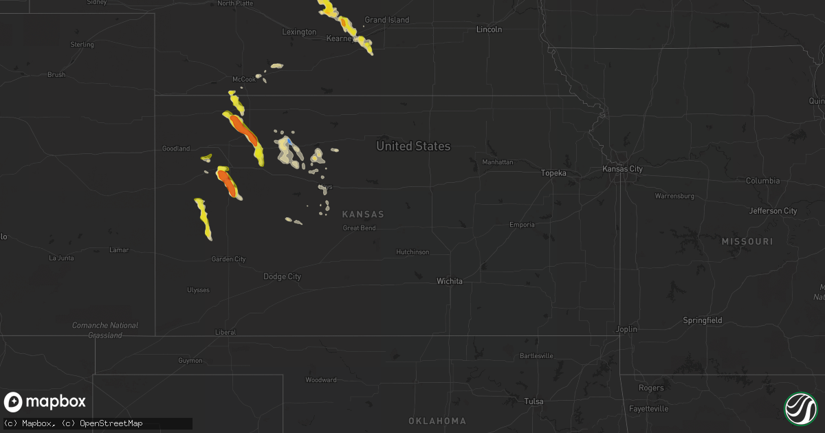
Hail Map in Kansas on July 22, 2022
Get this storm
July 22 map
$229
one time, instant access
Download today. No call, no setup
Keep the $229
Bought the map and want the full workflow? Apply the entire $229 to a subscription within 7 days. None of it is wasted.
Every map, not just this one
This buys you this map. Subscription and you get every map we run, in the markets you choose from a few cities to whole states to nationwide. Plus real-time alerts the moment a storm fires.
Contact data
Name, contact info, occupancy, even credit band for addresses in the footprint. You go from where it hit to who to call.
Become the source they trust
Unlimited branding weather history reports on demand. You already have the documented answer ready for the property owner, and you are the one who showed up with it.
Property data and RoofTrace estimates
Pull up any address you have got, its value and the exact code rules for that jurisdiction, straight from One Click Code. Then RoofTrace estimates the squares, pitch, and roof value, priced the way you price.
Storm reports in Kansas
Kansas
| Date | Description |
|---|---|
| 07/22/20226:57 PM CDT | A local report indicates 59 MPH wind near 12 NW SELDEN |
| 07/22/20226:45 PM CDT | From facebook: tree branches laying all over. Utility trailer picked up and dumped south of our house. Lean to building destroyed. Happened between 6:30 and 6:45 pm ct. |
| 07/22/20226:28 PM CDT | A local report indicates 61 MPH wind near 16 NNW LEOTI |
| 07/22/20225:28 PM CDT | Off-duty nws employee reported brief landspout near location. Also... Reported 2 brief and coincident landspouts in the same storm 4 minutes prior. |
| 07/22/20225:15 PM CDT | Landspout reported ese of goodland... Ks. Nws employee was on i-70 looking east southeast. |
| 07/22/20225:15 PM CDT | Corrects previous tornado report from 2 se goodland. Landspout reported ese of goodland... Ks. Nws employee was on i-70 looking east southeast. Location is approximate. |
| 07/22/20224:58 PM CDT | Corrects previous tornado report from 11 n brewster. Corrects previous tornado report from 13 ssw bird city. Landspout sighted about 10 miles east-southeast from the sh |
| 07/22/20224:58 PM CDT | Landspout sighted about 10 miles east-southeast from the sherman/cheyenne county line... North of edson... Ks. A second landspout was spotted a mile north of the first. |
| 07/22/20225:32 AM CDT | At 1031 PM CDT, a severe thunderstorm was located near Codell, or 13 miles north of Emmeram, moving east at 20 mph. HAZARD...60 mph wind gusts and nickel size hail. SOURCE...Radar indicated. IMPACT...Expect damage to roofs, siding, and trees. This severe thunderstorm will be near... Natoma around 1050 PM CDT. |
| 07/22/20225:25 AM CDT | At 1025 PM CDT, severe thunderstorms were located along a line extending from 6 miles south of Codell to near Schoenchen to 6 miles northwest of Bazine, moving southeast at 20 mph. HAZARD...60 mph wind gusts and nickel size hail. SOURCE...Radar indicated. IMPACT...Expect damage to roofs, siding, and trees. Severe thunderstorms will be near... Schoenchen, Liebenthal and Munjor around 1030 PM CDT. Loretta and Pfeifer around 1045 PM CDT.Other locations in the path of these severe thunderstorms includeAlexander, Otis and Nekoma. |
| 07/22/20225:04 AM CDT | At 1004 PM CDT, a severe thunderstorm was located 8 miles southeast of Stockton, or 26 miles north of Emmeram, moving southeast at 10 mph. HAZARD...60 mph wind gusts and quarter size hail. SOURCE...Radar indicated. IMPACT...Hail damage to vehicles is expected. Expect wind damage to roofs, siding, and trees. This severe thunderstorm will remain over mainly rural areas of southeastern Rooks County. |
| 07/22/20224:43 AM CDT | At 942 PM CDT, severe thunderstorms were located along a line extending from near Plainville to 8 miles northeast of Ogallah, moving southeast at 20 mph. HAZARD...60 mph wind gusts and quarter size hail. SOURCE...Radar indicated. IMPACT...Hail damage to vehicles is expected. Expect wind damage to roofs, siding, and trees. Severe thunderstorms will be near... Plainville around 1000 PM CDT.Other locations in the path of these severe thunderstorms includeCodell. |
| 07/22/20224:27 AM CDT | At 927 PM CDT, a severe thunderstorm was located 9 miles southwest of Palco, or 13 miles north of Ogallah, moving southeast at 20 mph. HAZARD...60 mph wind gusts and quarter size hail. SOURCE...Radar indicated. IMPACT...Hail damage to vehicles is expected. Expect wind damage to roofs, siding, and trees.PRECAUTIONARY/PREPAREDNESS ACTIONS...For your protection move to an interior room on the lowest floor of abuilding. |
| 07/22/20224:07 AM CDT | At 906 PM CDT, severe thunderstorms were located along a line extending from near Webster State Park to 7 miles south of Hill City, moving southeast at 20 mph. HAZARD...60 mph wind gusts and nickel size hail. SOURCE...Radar indicated. IMPACT...Expect damage to roofs, siding, and trees. Severe thunderstorms will be near... Damar and Webster State Park around 910 PM CDT.Other locations in the path of these severe thunderstorms includeZurich, Plainville and Codell. |
| 07/22/20224:06 AM CDT | At 906 PM CDT, a severe thunderstorm was located near Hill City, moving southeast at 30 mph. THIS IS A DESTRUCTIVE STORM FOR Southeastern Graham County. HAZARD...80 mph wind gusts and quarter size hail. SOURCE...Radar indicated. IMPACT...Flying debris will be dangerous to those caught without shelter. Mobile homes will be heavily damaged. Expect considerable damage to roofs, windows, and vehicles. Extensive tree damage and power outages are likely. This severe thunderstorm will remain over mainly rural areas of southeastern Graham County. |
| 07/22/20223:53 AM CDT | At 852 PM CDT, a severe thunderstorm was located 9 miles northeast of Scott State Lake, moving southeast at 20 mph. HAZARD...60 mph wind gusts and quarter size hail. SOURCE...Radar indicated. IMPACT...Hail damage to vehicles is expected. Expect wind damage to roofs, siding, and trees.PRECAUTIONARY/PREPAREDNESS ACTIONS...For your protection move to an interior room on the lowest floor of abuilding.Torrential rainfall is occurring with this storm, and may lead toflash flooding. Do not drive your vehicle through flooded roadways. |
| 07/22/20223:44 AM CDT | At 844 PM CDT, a severe thunderstorm was located 8 miles north of Park, or 11 miles north of Quinter, moving southeast at 20 mph. HAZARD...60 mph wind gusts and quarter size hail. SOURCE...Radar indicated. IMPACT...Hail damage to vehicles is expected. Expect wind damage to roofs, siding, and trees. This severe thunderstorm will be near... Quinter around 910 PM CDT.Other locations impacted by this severe thunderstorm include SaintPeter and Studley.This includes Interstate 70 in Kansas between mile markers 100 and113. |
| 07/22/20223:42 AM CDT | At 841 PM CDT, a severe thunderstorm was located 6 miles northeast of Morland, or 8 miles northwest of Hill City, moving southeast at 15 mph. HAZARD...70 mph wind gusts and quarter size hail. SOURCE...Radar indicated. IMPACT...Hail damage to vehicles is expected. Expect considerable tree damage. Wind damage is also likely to mobile homes, roofs, and outbuildings. Locations impacted include... Hill City and Bogue. |
| 07/22/20223:38 AM CDT | At 838 PM CDT, a severe thunderstorm was located 14 miles southwest of Modoc, moving south at 20 mph. HAZARD...60 mph wind gusts and quarter size hail. SOURCE...Radar indicated. IMPACT...Hail damage to vehicles is expected. Expect wind damage to roofs, siding, and trees. This severe thunderstorm will remain over mainly rural areas of southeastern Wichita County. |
| 07/22/20223:36 AM CDT | At 835 PM CDT, a severe thunderstorm was located 15 miles west of Friend, moving south at 15 mph. HAZARD...60 mph wind gusts and quarter size hail. SOURCE...Radar indicated. IMPACT...Hail damage to vehicles is expected. Expect wind damage to roofs, siding, and trees.PRECAUTIONARY/PREPAREDNESS ACTIONS...For your protection move to an interior room on the lowest floor of abuilding.Torrential rainfall is occurring with this storm, and may lead toflash flooding. Do not drive your vehicle through flooded roadways. |
| 07/22/20223:29 AM CDT | At 829 PM CDT, a severe thunderstorm was located 13 miles northeast of Scott State Lake, moving southeast at 25 mph. HAZARD...Ping pong ball size hail and 60 mph wind gusts. SOURCE...Radar indicated. IMPACT...People and animals outdoors will be injured. Expect hail damage to roofs, siding, windows, and vehicles. Expect wind damage to roofs, siding, and trees. This severe thunderstorm will remain over mainly rural areas of southeastern Logan and southern Gove Counties, including the following locations... The Monument Rocks. |
| 07/22/20222:56 AM CDT | At 756 PM CDT, a severe thunderstorm was located 4 miles north of Hoxie, moving southeast at 20 mph. HAZARD...70 mph wind gusts and ping pong ball size hail. SOURCE...Radar indicated. IMPACT...People and animals outdoors will be injured. Expect hail damage to roofs, siding, windows, and vehicles. Expect considerable tree damage. Wind damage is also likely to mobile homes, roofs, and outbuildings. This severe thunderstorm will remain over mainly rural areas of eastern Sheridan County, including the following locations... Tasco and Studley. |
| 07/22/20222:44 AM CDT | At 744 PM CDT, a severe thunderstorm was located 6 miles west of Modoc, moving southeast at 25 mph. HAZARD...Ping pong ball size hail and 60 mph wind gusts. SOURCE...Radar indicated. IMPACT...People and animals outdoors will be injured. Expect hail damage to roofs, siding, windows, and vehicles. Expect wind damage to roofs, siding, and trees. This severe thunderstorm will remain over mainly rural areas of southeastern Wichita County, including the following locations... Marienthal. |
| 07/22/20222:29 AM CDT | At 729 PM CDT, a severe thunderstorm was located 6 miles south of Monument, or 10 miles southwest of Oakley, moving southeast at 10 mph. HAZARD...Ping pong ball size hail and 60 mph wind gusts. SOURCE...Radar indicated. IMPACT...People and animals outdoors will be injured. Expect hail damage to roofs, siding, windows, and vehicles. Expect wind damage to roofs, siding, and trees. This severe thunderstorm will remain over mainly rural areas of northeastern Logan and northwestern Gove Counties. |
| 07/22/20222:16 AM CDT | At 716 PM CDT, a severe thunderstorm was located 7 miles northwest of Selden, or 17 miles southwest of Oberlin, moving southeast at 20 mph. HAZARD...Two inch hail and 70 mph wind gusts. SOURCE...Radar indicated. IMPACT...People and animals outdoors will be injured. Expect hail damage to roofs, siding, windows, and vehicles. Expect considerable tree damage. Wind damage is also likely to mobile homes, roofs, and outbuildings. This severe thunderstorm will be near... Selden around 735 PM CDT.Other locations impacted by this severe thunderstorm includeLeoville. |
| 07/22/20222:14 AM CDT | At 714 PM CDT, a severe thunderstorm was located 10 miles north of Leoti, moving southeast at 20 mph. HAZARD...Ping pong ball size hail and 60 mph wind gusts. SOURCE...Radar indicated. IMPACT...People and animals outdoors will be injured. Expect hail damage to roofs, siding, windows, and vehicles. Expect wind damage to roofs, siding, and trees. This severe thunderstorm will remain over mainly rural areas of northeastern Wichita County, including the following locations... Marienthal. |
| 07/22/20222:11 AM CDT | At 711 PM CDT, a severe thunderstorm was located 5 miles south of Monument, or 11 miles southwest of Oakley, moving east at 15 mph. HAZARD...Ping pong ball size hail and 60 mph wind gusts. SOURCE...Radar indicated. IMPACT...People and animals outdoors will be injured. Expect hail damage to roofs, siding, windows, and vehicles. Expect wind damage to roofs, siding, and trees. This severe thunderstorm will remain over mainly rural areas of northeastern Logan County. |
| 07/22/20221:40 AM CDT | At 640 PM CDT, a severe thunderstorm was located over Monument, or 7 miles west of Oakley, moving east at 15 mph. HAZARD...60 mph wind gusts and quarter size hail. SOURCE...Radar indicated. IMPACT...Hail damage to vehicles is expected. Expect wind damage to roofs, siding, and trees. Locations impacted include... Oakley.This includes Interstate 70 in Kansas between mile markers 71 and 79. |
| 07/22/20221:32 AM CDT | At 631 PM CDT, a severe thunderstorm was located 15 miles north of Leoti, moving east at 15 mph. HAZARD...70 mph wind gusts and nickel size hail. SOURCE...Radar indicated. At 628 PM CDT, a 61 mph wind gust was reported 16 miles NNW of Leoti, KS. IMPACT...Expect considerable tree damage. Damage is likely to mobile homes, roofs, and outbuildings. This severe thunderstorm will remain over mainly rural areas of northeastern Wichita and southwestern Logan Counties. |
| 07/22/20221:26 AM CDT | At 625 PM CDT, a severe thunderstorm was located 5 miles west of Oberlin, moving southeast at 20 mph. HAZARD...70 mph wind gusts and quarter size hail. Brief landspout tornadoes may be possible. SOURCE...Radar indicated. IMPACT...Hail damage to vehicles is expected. Expect considerable tree damage. Wind damage is also likely to mobile homes, roofs, and outbuildings. This severe thunderstorm will be near... Oberlin around 640 PM CDT. |
| 07/22/20221:00 AM CDT | At 600 PM CDT, a severe thunderstorm was located 6 miles south of Ludell, or 7 miles southeast of Atwood, moving southeast at 15 mph. HAZARD...60 mph wind gusts and quarter size hail. SOURCE...Radar indicated. IMPACT...Hail damage to vehicles is expected. Expect wind damage to roofs, siding, and trees. This severe thunderstorm will remain over mainly rural areas of east central Rawlins and west central Decatur Counties. |
| 07/22/202212:34 AM CDT | At 534 PM CDT, a severe thunderstorm was located 4 miles north of Herndon, or 16 miles northwest of Oberlin, and is nearly stationary. HAZARD...70 mph wind gusts and quarter size hail. SOURCE...Radar indicated. IMPACT...Hail damage to vehicles is expected. Expect considerable tree damage. Wind damage is also likely to mobile homes, roofs, and outbuildings. This severe thunderstorm will be near... Herndon around 610 PM CDT.Other locations impacted by this severe thunderstorm include Traer. |
| 07/21/202210:40 PM CDT | Awos station khys hays regional airport awos site. |
| 07/21/202210:29 PM CDT | Awos station khys hays regional airport awos site. |
| 07/21/20229:54 PM CDT | A local report indicates 59 MPH wind near PLAINVILLE |
| 07/21/20228:55 PM CDT | Videos sent in via social media showing multiple... Healthy tree branches broken off due to thunderstorm winds. Branches look to be about 4 inches in diameter. Time and |
| 07/21/20228:55 PM CDT | Delayed social media report with pictures of tree limbs down... The largest estimated to be about 6 inches in diameter. Time estimated from radar. |
| 07/21/20228:49 PM CDT | A local report indicates 82 MPH wind near 1 NE HILL CITY |
| 07/21/20228:46 PM CDT | Lawn furniture thrown... 6 inch tree limb damaged. Delayed report via social media. |
| 07/21/20228:46 PM CDT | Corrects previous tornado report from hill city. Delayed report via social media. Tornado... Possibly a landspout... Reported looking east from report location. Tornado |
| 07/21/20228:45 PM CDT | Delayed social media report of damage to healthy tree limb roughly 1 inch in diameter as estimated from accompanying video. |
| 07/21/20228:43 PM CDT | Delayed social media report with pictures of damage to a garage and a knocked over pull trailer. Time estimated from radar. |
| 07/21/20228:28 PM CDT | Corrects previous tstm wnd gst report from 11 nnw the monument rocks. Off-duty nws employee reports wind gusts of at least 70mph. Location estimated. Correction: employ |
| 07/21/20228:28 PM CDT | Corrects previous hail report from 11 nnw the monument rocks. Off-duty nws employee reports at least quarter-size hail. Location estimated. Correction: employee called |
| 07/21/20228:28 PM CDT | Off-duty nws employee reports wind gusts of at least 70mph. Location estimated. |
| 07/21/20228:28 PM CDT | Off-duty nws employee reports at least quarter-size hail. Location estimated. |
| 07/21/20228:14 PM CDT | A local report indicates 62 MPH wind near 5 S HOXIE |
| 07/21/20228:01 PM CDT | Kansas mesonet. 61 mph gust at 10 meter height... 45 mph gust at 2 meter height. |
| 07/21/20228:00 PM CDT | Estimated 60+ mph winds via facebook. |
| 07/21/20227:50 PM CDT | Spotter estimated wind gusts ranging 60-70mph. Time estimated. |
| 07/21/20227:50 PM CDT | Relayed pictures of damage to a hanger at the hoxie airport. Time estimated from radar. |
| 07/21/20227:45 PM CDT | Public report relayed through dispatch center. A tornado was reported around road w 30 n and road n 50 w. The tornado lifted at this point. |
| 07/21/20227:45 PM CDT | Delayed report from trained spotter. Time |
| 07/21/20227:39 PM CDT | Trained spotter reported hail about the size of quarters... Some were slightly larger than quarters. Winds near 50 mph were also estimated. |
| 07/21/20227:38 PM CDT | A local report indicates 70 MPH wind near 5 S SELDEN |
| 07/21/20227:35 PM CDT | Corrects previous tstm wnd gst report from 2 e leoti. Kansas mesonet. 61 mph gust at 10 meter height... 45 mph gust at 2 meter height. |
| 07/21/20227:30 PM CDT | Golf ball size hail was reported to the northeast with dime size hail to the west. |
| 07/21/20227:30 PM CDT | Thomas county dispatch forwarded report of tornado e of rexford. Deputies dispatched. |
| 07/21/20227:30 PM CDT | Public report relayed through dispatch center. A tornado was reported to have started in the vicinity of road n 130 w and road w 100 n. |
| 07/21/20227:14 PM CDT | A local report indicates 58 MPH wind near 14 SE LUDELL |
All States Impacted by Hail Map on July 22, 2022
Cities Impacted by Hail Map on July 22, 2022
- Franklin Grove, IL
- Kamrar, IA
- Newburg, ND
- Bristol, IN
- Elkhart, IN
- South Bend, IN
- Lakeville, IN
- Osceola, IN
- Columbia City, IN
- Kimmell, IN
- Cromwell, IN
- Goshen, IN
- Mishawaka, IN
- Ligonier, IN
- Galien, MI
- Nappanee, IN
- Syracuse, IN
- New Paris, IN
- Wakarusa, IN
- New Carlisle, IN
- Albion, IN
- Bremen, IN
- Rockford, IL
- Pecatonica, IL
- Winnebago, IL
- Blairsburg, IA
- Webster City, IA
- Dundee, NY
- Rock Stream, NY
- Wolcottville, IN
- Hudson, IN
- Bartley, NE
- Sobieski, WI
- Shawano, WI
- Krakow, WI
- Little Suamico, WI
- Cecil, WI
- Abrams, WI
- Oconto Falls, WI
- Green Valley, WI
- Gillett, WI
- Upham, ND
- Kramer, ND
- Morrison, IL
- Fulton, IL
- Milledgeville, IL
- Polo, IL
- Sterling, IL
- Mount Carroll, IL
- Chadwick, IL
- Thomson, IL
- Dixon, IL
- Woosung, IL
- Delhi, LA
- Kingston, GA
- Howe, IN
- Orland, IN
- Rattan, OK
- Snow, OK
- Nashoba, OK
- Cortland, NY
- McGraw, NY
- Truxton, NY
- Decaturville, TN
- Linden, TN
- Palos Heights, IL
- Palos Park, IL
- South Haven, MI
- Frederick, SD
- Wausau, WI
- Merrill, WI
- Argos, IN
- Culver, IN
- Kouts, IN
- Senoia, GA
- Tatum, NM
- Hanover, NM
- Minot Afb, ND
- Tolley, ND
- Berthold, ND
- Mohall, ND
- Kenmare, ND
- Maxbass, ND
- Sherwood, ND
- Glenburn, ND
- Donnybrook, ND
- Carpio, ND
- Lansford, ND
- Benton, WI
- Cuba City, WI
- Shullsburg, WI
- Hazel Green, WI
- Gratiot, WI
- Darlington, WI
- Burlington, WI
- Saint Michael, ND
- Warwick, ND
- Bantry, ND
- Granville, ND
- Colesburg, IA
- Greeley, IA
- Earlville, IA
- Florence, SD
- Milton, WI
- Edgerton, WI
- Janesville, WI
- Suring, WI
- Strasburg, ND
- Zeeland, ND
- Stratford, SD
- Mansfield, SD
- Ipswich, SD
- Pollock, SD
- Hague, ND
- Aberdeen, SD
- Andover, SD
- Westport, SD
- Groton, SD
- Leola, SD
- Hosmer, SD
- Ashley, ND
- Brentford, SD
- Herreid, SD
- Conde, SD
- Mellette, SD
- Warner, SD
- Long Lake, SD
- Eureka, SD
- Bennettsville, SC
- Winnsboro, LA
- Willcox, AZ
- Center Junction, IA
- Freeport, IL
- Coggon, IA
- Hanover, IL
- Anamosa, IA
- Stockton, IL
- Hopkinton, IA
- Kent, IL
- Galena, IL
- Savanna, IL
- Monticello, IA
- Bellevue, IA
- Scales Mound, IL
- Onslow, IA
- Cascade, IA
- Delhi, IA
- Lanark, IL
- Maquoketa, IA
- Bernard, IA
- La Motte, IA
- Zwingle, IA
- Central City, IA
- Ryan, IA
- Langworthy, IA
- Lena, IL
- Pearl City, IL
- Worthington, IA
- Elizabeth, IL
- Beloit, WI
- Edwardsburg, MI
- Lansing, IL
- Thornton, IL
- Chicago Heights, IL
- Glenwood, IL
- Munster, IN
- Etna Green, IN
- Cogan Station, PA
- Trout Run, PA
- Hill City, KS
- Morland, KS
- Jesup, GA
- Odum, GA
- Deering, ND
- Amherst, SD
- Burbank, IL
- Chicago Ridge, IL
- Worth, IL
- Oak Lawn, IL
- Alsip, IL
- Bridgeview, IL
- Elgin, ND
- New Leipzig, ND
- Interlaken, NY
- Trumansburg, NY
- King Ferry, NY
- Moravia, NY
- Lansing, NY
- Lodi, NY
- Genoa, NY
- Locke, NY
- Manchester, IA
- Bronson, MI
- Elgin, IL
- Hampshire, IL
- Saint Charles, IL
- Maple Park, IL
- Patrick, SC
- Cheraw, SC
- Bristol, SD
- Elida, NM
- Chicago, IL
- Caledonia, IL
- Balfour, ND
- Oberon, ND
- Maddock, ND
- Norwich, ND
- Rugby, ND
- New Rockford, ND
- Mchenry, ND
- Harvey, ND
- Towner, ND
- Esmond, ND
- Grace City, ND
- Karlsruhe, ND
- Surrey, ND
- Glenfield, ND
- Anamoose, ND
- Drake, ND
- Sheyenne, ND
- Fort Yates, ND
- Linton, ND
- Antler, ND
- Niles, MI
- Big Rock, IL
- Delavan, WI
- Whitewater, WI
- Allen, OK
- Atwood, OK
- Homewood, IL
- Tahoka, TX
- Sabula, IA
- Bastrop, LA
- Pleasant Lake, IN
- Ashley, IN
- Hamilton, IN
- Angola, IN
- Waterloo, IN
- Butler, IN
- Manteno, IL
- Bourbonnais, IL
- Lebanon, NE
- Andrews, SC
- Georgetown, SC
- Butler, GA
- Levant, KS
- Colby, KS
- Tallulah, LA
- Plymouth, IN
- Wilburton, OK
- Hays, KS
- Mauk, GA
- Animas, NM
- Cartersville, GA
- Hiram, GA
- Douglasville, GA
- Shelton, NE
- Olivehill, TN
- Clifton, TN
- Savannah, TN
- Belvidere, IL
- Punta Gorda, FL
- Racine, WI
- Franksville, WI
- Bylas, AZ
- Penokee, KS
- Lovelady, TX
- Crockett, TX
- Woodbury, GA
- Greenville, GA
- Middleburg, FL
- Bronson, FL
- Archer, FL
- Chiefland, FL
- Society Hill, SC
- Eagle, WI
- Palmyra, WI
- Monument, KS
- Grinnell, KS
- Oakley, KS
- Ogallah, KS
- Prague, OK
- Sparks, OK
- Solen, ND
- Le Raysville, PA
- Lake Villa, IL
- Oxford, FL
- Walnut, IL
- Traer, IA
- Marienthal, KS
- Winona, KS
- Deerfield, KS
- Leoti, KS
- Indianola, NE
- Palco, KS
- Plainville, KS
- Grovertown, IN
- Walkerton, IN
- Hamlet, IN
- Knox, IN
- Heartwell, NE
- Gibbon, NE
- Ravenna, NE
- Riverdale, NE
- Kearney, NE
- Holstein, NE
- Kenesaw, NE
- Roseland, NE
- Pleasanton, NE
- Minden, NE
- Wood River, NE
- Juniata, NE
- Pleasant Prairie, WI
- Clinton, LA
- Green Cove Springs, FL
- Herndon, KS
- Culbertson, NE
- Oberlin, KS
- Montgomery, IL
- Box Springs, GA
- Fort Benning, GA
- Aurora, IL
- Miller, NE
- Cherry Valley, IL
- Ness City, KS
- Bazine, KS
- Ellijay, GA
- Ellis, KS
- La Crosse, KS
- Levelland, TX
- San Pierre, IN
- Winamac, IN
- Medaryville, IN
- North Judson, IN
- Gilbert, LA
- Summerfield, FL
- Ocala, FL
- Alachua, FL
- Bogue, KS
- Ashkum, IL
- Hoxie, KS
- Littlefield, TX
- Center Point, IA
- Garrison, IA
- La Porte City, IA
- Vinton, IA
- Mount Auburn, IA
- Urbana, IA
- Alburnett, IA
- Monroe, LA
- Oak Ridge, LA
- Shiloh, GA
- Hamilton, GA
- Pine Mountain Valley, GA
- Brownell, KS
- Amherst, NE
- Hazard, NE
- Mason City, NE
- Oconto, NE
- Sand Springs, OK
- Waynesboro, TN
- Bonfield, IL
- Ozark, AL
- Fort Rucker, AL
- Enterprise, AL
- Garden Prairie, IL
- Morriston, FL
- Williston, FL
- White Oak, GA
- Geneseo, IL
- Osco, IL
- Cambridge, IL
- Chesterton, IN
- Union Mills, IN
- Wanatah, IN
- Beverly Shores, IN
- Westville, IN
- La Porte, IN
- Whiting, IN
- Michigan City, IN
- Hammond, IN
- East Chicago, IN
- Portage, IN
- Valparaiso, IN
- Woodston, KS
- Stockton, KS
- Kennesaw, GA
- Acworth, GA
- Oswego, IL
- Bristol, IL
- Yorkville, IL
- Plano, IL
- Sterlington, LA
- Vail, AZ
- Hanna, OK
- Dustin, OK
- Frankfort, IL
- Monee, IL
- Bristol, WI
- Kenosha, WI
- Patagonia, AZ
- Lake Village, IN
- Saint Anne, IL
- Morocco, IN
- Pembroke Township, IL
- Woodstock, IL
- Mchenry, IL
- Bovina, TX
- Farwell, TX
- Robins, IA
- Cedar Rapids, IA
- Marion, IA
- Lake Forest, IL
- Kempton, IL
- Cambridge, NE
- Holbrook, NE
- Eustis, NE
- Rayville, LA
- Romeoville, IL
- Kinta, OK
- Great Lakes, IL
- Fox Lake, IL
- Spring Grove, IL
- Vernon Hills, IL
- Wauconda, IL
- Highwood, IL
- Lake Zurich, IL
- Salem, WI
- Gurnee, IL
- Ingleside, IL
- Winthrop Harbor, IL
- Libertyville, IL
- Crystal Lake, IL
- Wonder Lake, IL
- Wadsworth, IL
- Barrington, IL
- Round Lake, IL
- Waukegan, IL
- Lake Bluff, IL
- Ringwood, IL
- North Chicago, IL
- Deerfield, IL
- Mundelein, IL
- Island Lake, IL
- Grayslake, IL
- Zion, IL
- Harvard, IL
- Cary, IL
- Marengo, IL
- Antioch, IL
- Union Grove, WI
- Highland Park, IL
- Rio Rico, AZ
- Nogales, AZ
- Preston, IA
- Spragueville, IA
- Ridott, IL
- Orangeville, IL
- Saint John, IN
- Crete, IL
- Dyer, IN
- University Park, IL
- Eufaula, AL
- Palo, IA
- Little River, SC
- Longs, SC
- Jasper, GA
- Post, TX
- Peru, IL
- Granville, IL
- Spring Valley, IL
- Atwood, KS
- Selden, KS
- Lovington, NM
- Dunnellon, FL
- Warrenville, IL
- Clarendon Hills, IL
- Plainfield, IL
- Westchester, IL
- Broadview, IL
- Wheaton, IL
- Franklin Park, IL
- Westmont, IL
- Hoffman Estates, IL
- Bensenville, IL
- Elmhurst, IL
- Itasca, IL
- Huntley, IL
- Downers Grove, IL
- Glendale Heights, IL
- Union, IL
- Hillside, IL
- Oak Brook, IL
- Lombard, IL
- Brookfield, IL
- Hines, IL
- Schiller Park, IL
- Batavia, IL
- Elburn, IL
- River Forest, IL
- Medinah, IL
- Elk Grove Village, IL
- Hinsdale, IL
- Waterman, IL
- Fox River Grove, IL
- Darien, IL
- Algonquin, IL
- La Grange Park, IL
- Rolling Meadows, IL
- Melrose Park, IL
- Riverside, IL
- Schaumburg, IL
- Forest Park, IL
- Des Plaines, IL
- Hanover Park, IL
- Lisle, IL
- Hinckley, IL
- North Aurora, IL
- La Grange, IL
- Naperville, IL
- Bartlett, IL
- Villa Park, IL
- Lemont, IL
- Lake In The Hills, IL
- Addison, IL
- Sugar Grove, IL
- Stone Park, IL
- Sandwich, IL
- Winfield, IL
- Dundee, IL
- Carol Stream, IL
- Bolingbrook, IL
- Willowbrook, IL
- Bloomingdale, IL
- Mount Prospect, IL
- Glen Ellyn, IL
- Geneva, IL
- Maywood, IL
- West Chicago, IL
- Berkeley, IL
- Roselle, IL
- Orland Park, IL
- Wood Dale, IL
- Lockport, IL
- Bellwood, IL
- Mooseheart, IL
- Woodridge, IL
- South Elgin, IL
- Homer Glen, IL
- Western Springs, IL
- Gilberts, IL
- Carpentersville, IL
- Arlington Heights, IL
- Streamwood, IL
- Somonauk, IL
- Santa Rosa, NM
- Cuervo, NM
- Colona, IL
- San Simon, AZ
- Utica, MS
- Benson, AZ
- Clayton, KS
- Dallas, GA
- Emerson, GA
- Reddick, IL
- Buckingham, IL
- Herscher, IL
- Sonoita, AZ
- Elgin, AZ
- Little Rock, SC
- Dillon, SC
- Marion, LA
- Parkersburg, WV
- Latta, SC
- Bradenton, FL
- Tolna, ND
- South Shore, SD
- Ortley, SD
- Baldwin, IA
- Monmouth, IA
- Claremont, SD
- Beecher, IL
- Walker, WV
- Petroleum, WV
- Mcville, ND
- Larwill, IN
- Pierceton, IN
- Prophetstown, IL
- East Moline, IL
- Carbon Cliff, IL
- Hillsdale, IL
- Evanston, IL
- Caledonia, WI
- Skokie, IL
- Wilmette, IL
- Silver Lake, WI
- Capron, IL
- Buffalo Grove, IL
- Wilmot, WI
- Kenilworth, IL
- Poplar Grove, IL
- Northbrook, IL
- Trevor, WI
- Twin Lakes, WI
- Glenview, IL
- Winnetka, IL
- Lincolnshire, IL
- Sturtevant, WI
- Glencoe, IL
- Union Pier, MI
- Three Oaks, MI
- New Buffalo, MI
- Glennville, GA
- Ludowici, GA
- Powder Springs, GA
- Summit, MS
- Antigo, WI
- Shields, ND
- Carson, ND
- Raleigh, ND
- Liebenthal, KS
- Interlachen, FL
- Hiawatha, IA
- Shellsburg, IA
- Toddville, IA
- Walker, IA
- Springville, IA
- Clutier, IA
- Gladbrook, IA
- Keystone, IA
- Van Horne, IA
- Toledo, IA
- Dysart, IA
- Waverly, WV
- Eau Claire, MI
- Berrien Center, MI
- Rock Falls, IL
- Tampico, IL
- North Liberty, IN
- Pekin, ND
- Crary, ND
- Aneta, ND
- Port Byron, IL
- Milford, IN
- Warsaw, IN
- Leesburg, IN
- Manhattan, IL
- Peotone, IL
- Parrish, FL
- Wimauma, FL
- Rome, PA
- Wysox, PA
- River Grove, IL
- Warren, IL
- Chebanse, IL
- Clifton, IL
- Kankakee, IL
- Selfridge, ND
- La Crosse, IN
- Williamstown, WV
- Vienna, WV
- Marietta, OH
- Jal, NM
- Sheffield, IL
- Mineral, IL
- Annawan, IL
- Wyanet, IL
- New Bedford, IL
- Jacksonville, FL
- Elkhorn, WI
- Fort Atkinson, WI
- Mukwonago, WI
- East Troy, WI
- Beaverville, IL
- Fair Oaks, IN
- Grant Park, IL
- Papineau, IL
- Cabery, IL
- Martinton, IL
- Momence, IL
- Waverly Hall, GA
- Fort McCoy, FL
- Palatka, FL
- Dalzell, SC
- Rembert, SC
- Yeso, NM
- Bishopville, SC
- Hecla, SD
- Wishek, ND
- Devils Lake, ND
- Wetumka, OK
- Chancellor, AL
- McCook, NE
- Gay, GA
- Marietta, GA
- Plains, TX
- McNeal, AZ
- New Orleans, LA
- Hanna, IN
- Kingsford Heights, IN
- Gary, IN
- Friendsville, PA
- Towanda, PA
- Wyalusing, PA
- Ulster, PA
- Warren Center, PA
- Lamar, SC
- Gainesville, FL
- Gibsonton, FL
- Ruskin, FL
- Apollo Beach, FL
- Wakeeney, KS
- Watertown, SD
- Hamer, SC
- Newnan, GA
- Lamar, OK
- New Lenox, IL
- Mokena, IL
- Joliet, IL
- Machesney Park, IL
- Loves Park, IL
- Highland, IN
- Griffith, IN
- Hebron, IN
- Demotte, IN
- Wheatfield, IN
- Park, KS
- Minot, ND
- Corunna, IN
- North Webster, IN
- Churubusco, IN
- Millersburg, IN
- Brook, IN
- Shelby, IN
- Mount Ayr, IN
- Lowell, IN
- Thayer, IN
- Remington, IN
- Wolcott, IN
- Monterey, IN
- Rensselaer, IN
- Ora, IN
- Francesville, IN
- Monon, IN
- Schneider, IN
- Goodland, IN
- Saint Petersburg, FL
- Roscoe, SD
- Binford, ND
- Fessenden, ND
- Cathay, ND
- Bisbee, ND
- Wolford, ND
- Cando, ND
- York, ND
- Mayville, ND
- Niagara, ND
- Emerado, ND
- Forest River, ND
- Red Lake Falls, MN
- Churchs Ferry, ND
- Lawton, ND
- Penn, ND
- Crookston, MN
- Reynolds, ND
- East Grand Forks, MN
- Webster, ND
- Fordville, ND
- Oklee, MN
- Plummer, MN
- Larimore, ND
- Michigan, ND
- Northwood, ND
- Fisher, MN
- Gilby, ND
- Brooks, MN
- Mcintosh, MN
- Inkster, ND
- Thompson, ND
- Sharon, ND
- Arvilla, ND
- Climax, MN
- Grand Forks, ND
- Mekinock, ND
- Grand Forks Afb, ND
- Mentor, MN
- Trail, MN
- Buxton, ND
- Erskine, MN
- Brocket, ND
- Lakota, ND
- Petersburg, ND
- Hatton, ND
- Roswell, NM
- Crest Hill, IL
- Elmwood Park, IL
- Elwood, IL


