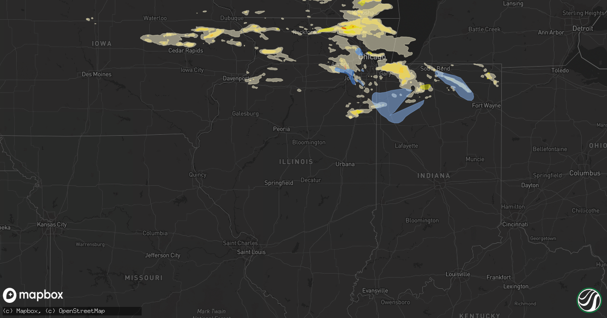
Hail Map in Illinois on July 22, 2022
Get this storm
July 22 map
$229
one time, instant access
Download today. No call, no setup
Keep the $229
Bought the map and want the full workflow? Apply the entire $229 to a subscription within 7 days. None of it is wasted.
Every map, not just this one
This buys you this map. Subscription and you get every map we run, in the markets you choose from a few cities to whole states to nationwide. Plus real-time alerts the moment a storm fires.
Contact data
Name, contact info, occupancy, even credit band for addresses in the footprint. You go from where it hit to who to call.
Become the source they trust
Unlimited branding weather history reports on demand. You already have the documented answer ready for the property owner, and you are the one who showed up with it.
Property data and RoofTrace estimates
Pull up any address you have got, its value and the exact code rules for that jurisdiction, straight from One Click Code. Then RoofTrace estimates the squares, pitch, and roof value, priced the way you price.
Storm reports in Illinois
Illinois
| Date | Description |
|---|---|
| 07/22/20226:56 AM CDT | At 1156 PM CDT, a severe thunderstorm was located near Marengo, moving east at 45 mph. HAZARD...60 mph wind gusts and half dollar size hail. SOURCE...Radar indicated. IMPACT...Hail damage to vehicles is expected. Expect wind damage to roofs, siding, and trees. Locations impacted include... Crystal Lake, McHenry, Woodstock, Fox Lake, Island Lake, Marengo, Cary, Johnsburg, Lakemoor, Spring Grove, Wonder Lake, Lakewood, Pistakee Highlands, Oakwood Hills, Prairie Grove, Richmond, Port Barrington, Bull Valley, McCullom Lake and Ringwood.This includes... Mchenry County College, Mchenry County Fairgrounds,and Moraine Hills State Park. |
| 07/22/20226:00 AM CDT | Large tree limb snapped off tree. Time estimated from radar. |
| 07/22/20225:53 AM CDT | Large tree branches and tree limbs downed in romeoville. Time estimated from radar. |
| 07/22/20225:41 AM CDT | Initial nws storm survey and downstream tornadic debris signature on radar confirm a tornado in south naperville with an approximate starting point in a shopping plaza |
| 07/22/20225:32 AM CDT | A couple of tree branches about 3-6 inches in diameter were downed near the niu coop station. Time estimated based on kdkb awos peak gust. |
| 07/22/20225:17 AM CDT | Large tree limbs downed in niles. Time estimated from radar. |
| 07/22/20225:15 AM CDT | Several trees and 4-6 inch diameter branches downed in rochelle. Time estimated based on krpj awos peak gust. |
| 07/22/20225:15 AM CDT | Krpj awos peak gust. |
| 07/22/20225:05 AM CDT | Video shared on social media shows several large tree branches and tree limbs downed in ashton. Time estimated from radar. |
| 07/22/20224:21 AM CDT | Several 3 inch diameter tree limbs and one 20 foot long... 6 inch diameter tree limb downed. Time estimated from radar. |
| 07/22/20224:10 AM CDT | Occurring right now. |
| 07/22/20224:10 AM CDT | Spotter reported damage from wind driven hail at this location. Winds and hail combined to cause two pieces of siding to fall off... Along with damage to a window and m |
| 07/22/20223:38 AM CDT | Delayed report. From a personal weather station. |
| 07/22/20221:46 AM CDT | From second storm that passed through round lake. |
| 07/22/20221:45 AM CDT | Photo received via twitter. |
| 07/22/20221:23 AM CDT | Photo shared on social media showing hail approximately 1.5 inches in diameter in grayslake. Time estimated from radar. |
| 07/22/20221:22 AM CDT | Photo shared on social media showing quarter size hail in round lake beach. Time estimated from radar. |
| 07/22/20221:21 AM CDT | Photo shared on social media showing quarter size hail in round lake. Time estimated from radar. |
| 07/22/20221:20 AM CDT | Multiple reports of penny to quarter size hail in mundelein. |
| 07/22/20221:14 AM CDT | Measured size... With photo received on twitter. |
| 07/22/20221:00 AM CDT | Multiple reports of nickel to quarter size hail in mchenry. |
| 07/22/202212:59 AM CDT | Time estimated from radar. |
| 07/22/202212:28 AM CDT | Multiple reports of nickel to quarter size hail in lake villa. Time estimated from radar. |
| 07/21/202211:05 PM CDT | Photo shared on social media showing quarter size hailstone in old irving park. Several other reports of half inch to quarter size hail in the irving park and albany pa |
All States Impacted by Hail Map on July 22, 2022
Cities Impacted by Hail Map on July 22, 2022
- Franklin Grove, IL
- Kamrar, IA
- Newburg, ND
- Bristol, IN
- Elkhart, IN
- South Bend, IN
- Lakeville, IN
- Osceola, IN
- Columbia City, IN
- Kimmell, IN
- Cromwell, IN
- Goshen, IN
- Mishawaka, IN
- Ligonier, IN
- Galien, MI
- Nappanee, IN
- Syracuse, IN
- New Paris, IN
- Wakarusa, IN
- New Carlisle, IN
- Albion, IN
- Bremen, IN
- Rockford, IL
- Pecatonica, IL
- Winnebago, IL
- Blairsburg, IA
- Webster City, IA
- Dundee, NY
- Rock Stream, NY
- Wolcottville, IN
- Hudson, IN
- Bartley, NE
- Sobieski, WI
- Shawano, WI
- Krakow, WI
- Little Suamico, WI
- Cecil, WI
- Abrams, WI
- Oconto Falls, WI
- Green Valley, WI
- Gillett, WI
- Upham, ND
- Kramer, ND
- Morrison, IL
- Fulton, IL
- Milledgeville, IL
- Polo, IL
- Sterling, IL
- Mount Carroll, IL
- Chadwick, IL
- Thomson, IL
- Dixon, IL
- Woosung, IL
- Delhi, LA
- Kingston, GA
- Howe, IN
- Orland, IN
- Rattan, OK
- Snow, OK
- Nashoba, OK
- Cortland, NY
- McGraw, NY
- Truxton, NY
- Decaturville, TN
- Linden, TN
- Palos Heights, IL
- Palos Park, IL
- South Haven, MI
- Frederick, SD
- Wausau, WI
- Merrill, WI
- Argos, IN
- Culver, IN
- Kouts, IN
- Senoia, GA
- Tatum, NM
- Hanover, NM
- Minot Afb, ND
- Tolley, ND
- Berthold, ND
- Mohall, ND
- Kenmare, ND
- Maxbass, ND
- Sherwood, ND
- Glenburn, ND
- Donnybrook, ND
- Carpio, ND
- Lansford, ND
- Benton, WI
- Cuba City, WI
- Shullsburg, WI
- Hazel Green, WI
- Gratiot, WI
- Darlington, WI
- Burlington, WI
- Saint Michael, ND
- Warwick, ND
- Bantry, ND
- Granville, ND
- Colesburg, IA
- Greeley, IA
- Earlville, IA
- Florence, SD
- Milton, WI
- Edgerton, WI
- Janesville, WI
- Suring, WI
- Strasburg, ND
- Zeeland, ND
- Stratford, SD
- Mansfield, SD
- Ipswich, SD
- Pollock, SD
- Hague, ND
- Aberdeen, SD
- Andover, SD
- Westport, SD
- Groton, SD
- Leola, SD
- Hosmer, SD
- Ashley, ND
- Brentford, SD
- Herreid, SD
- Conde, SD
- Mellette, SD
- Warner, SD
- Long Lake, SD
- Eureka, SD
- Bennettsville, SC
- Winnsboro, LA
- Willcox, AZ
- Center Junction, IA
- Freeport, IL
- Coggon, IA
- Hanover, IL
- Anamosa, IA
- Stockton, IL
- Hopkinton, IA
- Kent, IL
- Galena, IL
- Savanna, IL
- Monticello, IA
- Bellevue, IA
- Scales Mound, IL
- Onslow, IA
- Cascade, IA
- Delhi, IA
- Lanark, IL
- Maquoketa, IA
- Bernard, IA
- La Motte, IA
- Zwingle, IA
- Central City, IA
- Ryan, IA
- Langworthy, IA
- Lena, IL
- Pearl City, IL
- Worthington, IA
- Elizabeth, IL
- Beloit, WI
- Edwardsburg, MI
- Lansing, IL
- Thornton, IL
- Chicago Heights, IL
- Glenwood, IL
- Munster, IN
- Etna Green, IN
- Cogan Station, PA
- Trout Run, PA
- Hill City, KS
- Morland, KS
- Jesup, GA
- Odum, GA
- Deering, ND
- Amherst, SD
- Burbank, IL
- Chicago Ridge, IL
- Worth, IL
- Oak Lawn, IL
- Alsip, IL
- Bridgeview, IL
- Elgin, ND
- New Leipzig, ND
- Interlaken, NY
- Trumansburg, NY
- King Ferry, NY
- Moravia, NY
- Lansing, NY
- Lodi, NY
- Genoa, NY
- Locke, NY
- Manchester, IA
- Bronson, MI
- Elgin, IL
- Hampshire, IL
- Saint Charles, IL
- Maple Park, IL
- Patrick, SC
- Cheraw, SC
- Bristol, SD
- Elida, NM
- Chicago, IL
- Caledonia, IL
- Balfour, ND
- Oberon, ND
- Maddock, ND
- Norwich, ND
- Rugby, ND
- New Rockford, ND
- Mchenry, ND
- Harvey, ND
- Towner, ND
- Esmond, ND
- Grace City, ND
- Karlsruhe, ND
- Surrey, ND
- Glenfield, ND
- Anamoose, ND
- Drake, ND
- Sheyenne, ND
- Fort Yates, ND
- Linton, ND
- Antler, ND
- Niles, MI
- Big Rock, IL
- Delavan, WI
- Whitewater, WI
- Allen, OK
- Atwood, OK
- Homewood, IL
- Tahoka, TX
- Sabula, IA
- Bastrop, LA
- Pleasant Lake, IN
- Ashley, IN
- Hamilton, IN
- Angola, IN
- Waterloo, IN
- Butler, IN
- Manteno, IL
- Bourbonnais, IL
- Lebanon, NE
- Andrews, SC
- Georgetown, SC
- Butler, GA
- Levant, KS
- Colby, KS
- Tallulah, LA
- Plymouth, IN
- Wilburton, OK
- Hays, KS
- Mauk, GA
- Animas, NM
- Cartersville, GA
- Hiram, GA
- Douglasville, GA
- Shelton, NE
- Olivehill, TN
- Clifton, TN
- Savannah, TN
- Belvidere, IL
- Punta Gorda, FL
- Racine, WI
- Franksville, WI
- Bylas, AZ
- Penokee, KS
- Lovelady, TX
- Crockett, TX
- Woodbury, GA
- Greenville, GA
- Middleburg, FL
- Bronson, FL
- Archer, FL
- Chiefland, FL
- Society Hill, SC
- Eagle, WI
- Palmyra, WI
- Monument, KS
- Grinnell, KS
- Oakley, KS
- Ogallah, KS
- Prague, OK
- Sparks, OK
- Solen, ND
- Le Raysville, PA
- Lake Villa, IL
- Oxford, FL
- Walnut, IL
- Traer, IA
- Marienthal, KS
- Winona, KS
- Deerfield, KS
- Leoti, KS
- Indianola, NE
- Palco, KS
- Plainville, KS
- Grovertown, IN
- Walkerton, IN
- Hamlet, IN
- Knox, IN
- Heartwell, NE
- Gibbon, NE
- Ravenna, NE
- Riverdale, NE
- Kearney, NE
- Holstein, NE
- Kenesaw, NE
- Roseland, NE
- Pleasanton, NE
- Minden, NE
- Wood River, NE
- Juniata, NE
- Pleasant Prairie, WI
- Clinton, LA
- Green Cove Springs, FL
- Herndon, KS
- Culbertson, NE
- Oberlin, KS
- Montgomery, IL
- Box Springs, GA
- Fort Benning, GA
- Aurora, IL
- Miller, NE
- Cherry Valley, IL
- Ness City, KS
- Bazine, KS
- Ellijay, GA
- Ellis, KS
- La Crosse, KS
- Levelland, TX
- San Pierre, IN
- Winamac, IN
- Medaryville, IN
- North Judson, IN
- Gilbert, LA
- Summerfield, FL
- Ocala, FL
- Alachua, FL
- Bogue, KS
- Ashkum, IL
- Hoxie, KS
- Littlefield, TX
- Center Point, IA
- Garrison, IA
- La Porte City, IA
- Vinton, IA
- Mount Auburn, IA
- Urbana, IA
- Alburnett, IA
- Monroe, LA
- Oak Ridge, LA
- Shiloh, GA
- Hamilton, GA
- Pine Mountain Valley, GA
- Brownell, KS
- Amherst, NE
- Hazard, NE
- Mason City, NE
- Oconto, NE
- Sand Springs, OK
- Waynesboro, TN
- Bonfield, IL
- Ozark, AL
- Fort Rucker, AL
- Enterprise, AL
- Garden Prairie, IL
- Morriston, FL
- Williston, FL
- White Oak, GA
- Geneseo, IL
- Osco, IL
- Cambridge, IL
- Chesterton, IN
- Union Mills, IN
- Wanatah, IN
- Beverly Shores, IN
- Westville, IN
- La Porte, IN
- Whiting, IN
- Michigan City, IN
- Hammond, IN
- East Chicago, IN
- Portage, IN
- Valparaiso, IN
- Woodston, KS
- Stockton, KS
- Kennesaw, GA
- Acworth, GA
- Oswego, IL
- Bristol, IL
- Yorkville, IL
- Plano, IL
- Sterlington, LA
- Vail, AZ
- Hanna, OK
- Dustin, OK
- Frankfort, IL
- Monee, IL
- Bristol, WI
- Kenosha, WI
- Patagonia, AZ
- Lake Village, IN
- Saint Anne, IL
- Morocco, IN
- Pembroke Township, IL
- Woodstock, IL
- Mchenry, IL
- Bovina, TX
- Farwell, TX
- Robins, IA
- Cedar Rapids, IA
- Marion, IA
- Lake Forest, IL
- Kempton, IL
- Cambridge, NE
- Holbrook, NE
- Eustis, NE
- Rayville, LA
- Romeoville, IL
- Kinta, OK
- Great Lakes, IL
- Fox Lake, IL
- Spring Grove, IL
- Vernon Hills, IL
- Wauconda, IL
- Highwood, IL
- Lake Zurich, IL
- Salem, WI
- Gurnee, IL
- Ingleside, IL
- Winthrop Harbor, IL
- Libertyville, IL
- Crystal Lake, IL
- Wonder Lake, IL
- Wadsworth, IL
- Barrington, IL
- Round Lake, IL
- Waukegan, IL
- Lake Bluff, IL
- Ringwood, IL
- North Chicago, IL
- Deerfield, IL
- Mundelein, IL
- Island Lake, IL
- Grayslake, IL
- Zion, IL
- Harvard, IL
- Cary, IL
- Marengo, IL
- Antioch, IL
- Union Grove, WI
- Highland Park, IL
- Rio Rico, AZ
- Nogales, AZ
- Preston, IA
- Spragueville, IA
- Ridott, IL
- Orangeville, IL
- Saint John, IN
- Crete, IL
- Dyer, IN
- University Park, IL
- Eufaula, AL
- Palo, IA
- Little River, SC
- Longs, SC
- Jasper, GA
- Post, TX
- Peru, IL
- Granville, IL
- Spring Valley, IL
- Atwood, KS
- Selden, KS
- Lovington, NM
- Dunnellon, FL
- Warrenville, IL
- Clarendon Hills, IL
- Plainfield, IL
- Westchester, IL
- Broadview, IL
- Wheaton, IL
- Franklin Park, IL
- Westmont, IL
- Hoffman Estates, IL
- Bensenville, IL
- Elmhurst, IL
- Itasca, IL
- Huntley, IL
- Downers Grove, IL
- Glendale Heights, IL
- Union, IL
- Hillside, IL
- Oak Brook, IL
- Lombard, IL
- Brookfield, IL
- Hines, IL
- Schiller Park, IL
- Batavia, IL
- Elburn, IL
- River Forest, IL
- Medinah, IL
- Elk Grove Village, IL
- Hinsdale, IL
- Waterman, IL
- Fox River Grove, IL
- Darien, IL
- Algonquin, IL
- La Grange Park, IL
- Rolling Meadows, IL
- Melrose Park, IL
- Riverside, IL
- Schaumburg, IL
- Forest Park, IL
- Des Plaines, IL
- Hanover Park, IL
- Lisle, IL
- Hinckley, IL
- North Aurora, IL
- La Grange, IL
- Naperville, IL
- Bartlett, IL
- Villa Park, IL
- Lemont, IL
- Lake In The Hills, IL
- Addison, IL
- Sugar Grove, IL
- Stone Park, IL
- Sandwich, IL
- Winfield, IL
- Dundee, IL
- Carol Stream, IL
- Bolingbrook, IL
- Willowbrook, IL
- Bloomingdale, IL
- Mount Prospect, IL
- Glen Ellyn, IL
- Geneva, IL
- Maywood, IL
- West Chicago, IL
- Berkeley, IL
- Roselle, IL
- Orland Park, IL
- Wood Dale, IL
- Lockport, IL
- Bellwood, IL
- Mooseheart, IL
- Woodridge, IL
- South Elgin, IL
- Homer Glen, IL
- Western Springs, IL
- Gilberts, IL
- Carpentersville, IL
- Arlington Heights, IL
- Streamwood, IL
- Somonauk, IL
- Santa Rosa, NM
- Cuervo, NM
- Colona, IL
- San Simon, AZ
- Utica, MS
- Benson, AZ
- Clayton, KS
- Dallas, GA
- Emerson, GA
- Reddick, IL
- Buckingham, IL
- Herscher, IL
- Sonoita, AZ
- Elgin, AZ
- Little Rock, SC
- Dillon, SC
- Marion, LA
- Parkersburg, WV
- Latta, SC
- Bradenton, FL
- Tolna, ND
- South Shore, SD
- Ortley, SD
- Baldwin, IA
- Monmouth, IA
- Claremont, SD
- Beecher, IL
- Walker, WV
- Petroleum, WV
- Mcville, ND
- Larwill, IN
- Pierceton, IN
- Prophetstown, IL
- East Moline, IL
- Carbon Cliff, IL
- Hillsdale, IL
- Evanston, IL
- Caledonia, WI
- Skokie, IL
- Wilmette, IL
- Silver Lake, WI
- Capron, IL
- Buffalo Grove, IL
- Wilmot, WI
- Kenilworth, IL
- Poplar Grove, IL
- Northbrook, IL
- Trevor, WI
- Twin Lakes, WI
- Glenview, IL
- Winnetka, IL
- Lincolnshire, IL
- Sturtevant, WI
- Glencoe, IL
- Union Pier, MI
- Three Oaks, MI
- New Buffalo, MI
- Glennville, GA
- Ludowici, GA
- Powder Springs, GA
- Summit, MS
- Antigo, WI
- Shields, ND
- Carson, ND
- Raleigh, ND
- Liebenthal, KS
- Interlachen, FL
- Hiawatha, IA
- Shellsburg, IA
- Toddville, IA
- Walker, IA
- Springville, IA
- Clutier, IA
- Gladbrook, IA
- Keystone, IA
- Van Horne, IA
- Toledo, IA
- Dysart, IA
- Waverly, WV
- Eau Claire, MI
- Berrien Center, MI
- Rock Falls, IL
- Tampico, IL
- North Liberty, IN
- Pekin, ND
- Crary, ND
- Aneta, ND
- Port Byron, IL
- Milford, IN
- Warsaw, IN
- Leesburg, IN
- Manhattan, IL
- Peotone, IL
- Parrish, FL
- Wimauma, FL
- Rome, PA
- Wysox, PA
- River Grove, IL
- Warren, IL
- Chebanse, IL
- Clifton, IL
- Kankakee, IL
- Selfridge, ND
- La Crosse, IN
- Williamstown, WV
- Vienna, WV
- Marietta, OH
- Jal, NM
- Sheffield, IL
- Mineral, IL
- Annawan, IL
- Wyanet, IL
- New Bedford, IL
- Jacksonville, FL
- Elkhorn, WI
- Fort Atkinson, WI
- Mukwonago, WI
- East Troy, WI
- Beaverville, IL
- Fair Oaks, IN
- Grant Park, IL
- Papineau, IL
- Cabery, IL
- Martinton, IL
- Momence, IL
- Waverly Hall, GA
- Fort McCoy, FL
- Palatka, FL
- Dalzell, SC
- Rembert, SC
- Yeso, NM
- Bishopville, SC
- Hecla, SD
- Wishek, ND
- Devils Lake, ND
- Wetumka, OK
- Chancellor, AL
- McCook, NE
- Gay, GA
- Marietta, GA
- Plains, TX
- McNeal, AZ
- New Orleans, LA
- Hanna, IN
- Kingsford Heights, IN
- Gary, IN
- Friendsville, PA
- Towanda, PA
- Wyalusing, PA
- Ulster, PA
- Warren Center, PA
- Lamar, SC
- Gainesville, FL
- Gibsonton, FL
- Ruskin, FL
- Apollo Beach, FL
- Wakeeney, KS
- Watertown, SD
- Hamer, SC
- Newnan, GA
- Lamar, OK
- New Lenox, IL
- Mokena, IL
- Joliet, IL
- Machesney Park, IL
- Loves Park, IL
- Highland, IN
- Griffith, IN
- Hebron, IN
- Demotte, IN
- Wheatfield, IN
- Park, KS
- Minot, ND
- Corunna, IN
- North Webster, IN
- Churubusco, IN
- Millersburg, IN
- Brook, IN
- Shelby, IN
- Mount Ayr, IN
- Lowell, IN
- Thayer, IN
- Remington, IN
- Wolcott, IN
- Monterey, IN
- Rensselaer, IN
- Ora, IN
- Francesville, IN
- Monon, IN
- Schneider, IN
- Goodland, IN
- Saint Petersburg, FL
- Roscoe, SD
- Binford, ND
- Fessenden, ND
- Cathay, ND
- Bisbee, ND
- Wolford, ND
- Cando, ND
- York, ND
- Mayville, ND
- Niagara, ND
- Emerado, ND
- Forest River, ND
- Red Lake Falls, MN
- Churchs Ferry, ND
- Lawton, ND
- Penn, ND
- Crookston, MN
- Reynolds, ND
- East Grand Forks, MN
- Webster, ND
- Fordville, ND
- Oklee, MN
- Plummer, MN
- Larimore, ND
- Michigan, ND
- Northwood, ND
- Fisher, MN
- Gilby, ND
- Brooks, MN
- Mcintosh, MN
- Inkster, ND
- Thompson, ND
- Sharon, ND
- Arvilla, ND
- Climax, MN
- Grand Forks, ND
- Mekinock, ND
- Grand Forks Afb, ND
- Mentor, MN
- Trail, MN
- Buxton, ND
- Erskine, MN
- Brocket, ND
- Lakota, ND
- Petersburg, ND
- Hatton, ND
- Roswell, NM
- Crest Hill, IL
- Elmwood Park, IL
- Elwood, IL


