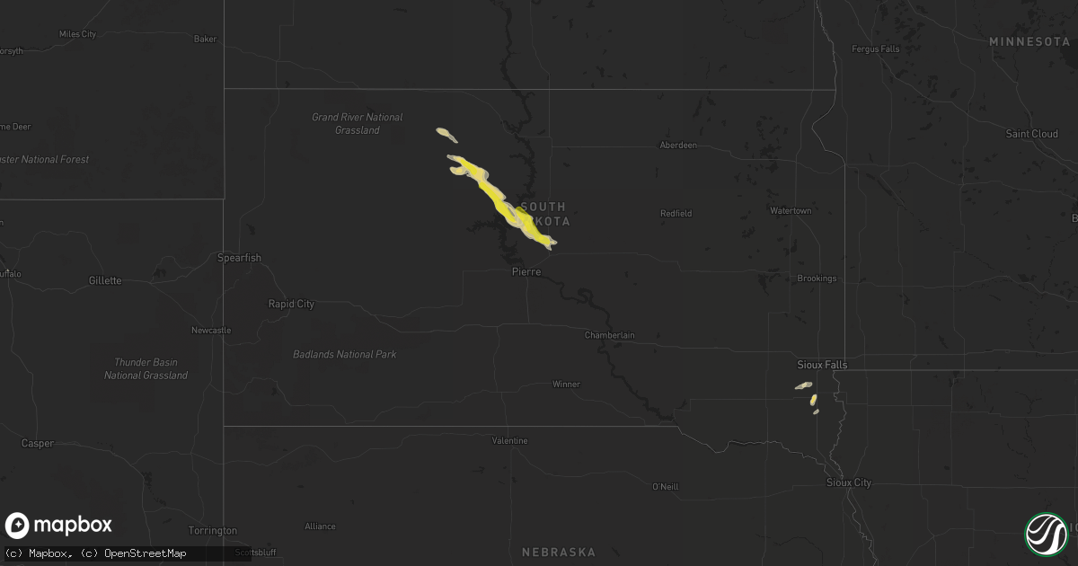
Hail Map in South Dakota on July 22, 2020
Get this storm
July 22 map
$229
one time, instant access
Download today. No call, no setup
Keep the $229
Bought the map and want the full workflow? Apply the entire $229 to a subscription within 7 days. None of it is wasted.
Every map, not just this one
This buys you this map. Subscription and you get every map we run, in the markets you choose from a few cities to whole states to nationwide. Plus real-time alerts the moment a storm fires.
Contact data
Name, contact info, occupancy, even credit band for addresses in the footprint. You go from where it hit to who to call.
Become the source they trust
Unlimited branding weather history reports on demand. You already have the documented answer ready for the property owner, and you are the one who showed up with it.
Property data and RoofTrace estimates
Pull up any address you have got, its value and the exact code rules for that jurisdiction, straight from One Click Code. Then RoofTrace estimates the squares, pitch, and roof value, priced the way you price.
Storm reports in South Dakota
South Dakota
| Date | Description |
|---|---|
| 07/22/20208:55 AM CDT | A local report indicates 1.00 inch wind near 4 W ONIDA |
| 07/22/20204:46 AM CDT | At 945 AM CDT/845 AM MDT/, a severe thunderstorm was located 10 miles north of Little Bend Rec Area, or 29 miles northwest of Onida, moving southeast at 20 mph. HAZARD...Ping pong ball size hail and 60 mph wind gusts. SOURCE...Radar indicated. IMPACT...People and animals outdoors will be injured. Expect hail damage to roofs, siding, windows, and vehicles. Expect wind damage to roofs, siding, and trees. Locations impacted include... Bush'S Landing, Sutton Bay Rec Area, Little Bend Rec Area and Lake Oahe. |
| 07/22/20204:38 AM CDT | At 937 AM CDT, a severe thunderstorm was located near Onida, moving east at 20 mph. HAZARD...60 mph wind gusts and quarter size hail. SOURCE...Radar indicated. IMPACT...Hail damage to vehicles is expected. Expect wind damage to roofs, siding, and trees. Locations impacted include... Onida, Blunt and Harrold. |
| 07/22/20203:47 AM CDT | At 847 AM CDT/747 AM MDT/, a severe thunderstorm was located near Sully Lake, or near Onida, moving east at 20 mph. HAZARD...60 mph wind gusts and quarter size hail. SOURCE...Radar indicated. IMPACT...Hail damage to vehicles is expected. Expect wind damage to roofs, siding, and trees. Locations impacted include... Onida, Blunt and Sully Lake. |
| 07/22/20203:10 AM CDT | At 809 AM MDT, a severe thunderstorm was located over Ridgeview, or 21 miles east of Eagle Butte, moving southeast at 20 mph. HAZARD...60 mph wind gusts and quarter size hail. SOURCE...Radar indicated. IMPACT...Hail damage to vehicles is expected. Expect wind damage to roofs, siding, and trees. Locations impacted include... Ridgeview. |
| 07/22/20203:08 AM CDT | At 808 AM CDT/708 AM MDT/, a severe thunderstorm was located over southeastern Lake Oahe, or 21 miles west of Onida, moving east at 25 mph. HAZARD...60 mph wind gusts and quarter size hail. SOURCE...Radar indicated. IMPACT...Hail damage to vehicles is expected. Expect wind damage to roofs, siding, and trees. Locations impacted include... Bush'S Landing, Sutton Bay Rec Area, Sully Lake and Lake Oahe. |
| 07/22/20202:44 AM CDT | At 744 AM MDT, a severe thunderstorm was located near White Horse, or 18 miles northeast of Eagle Butte, moving southeast at 20 mph. HAZARD...Ping pong ball size hail and 60 mph wind gusts. SOURCE...Radar indicated. IMPACT...People and animals outdoors will be injured. Expect hail damage to roofs, siding, windows, and vehicles. Expect wind damage to roofs, siding, and trees. Locations impacted include... Ridgeview. |
| 07/22/20202:09 AM CDT | At 709 AM MDT, a severe thunderstorm was located near Ridgeview, or 25 miles east of Eagle Butte, moving east at 10 mph. HAZARD...60 mph wind gusts and quarter size hail. SOURCE...Radar indicated. IMPACT...Hail damage to vehicles is expected. Expect wind damage to roofs, siding, and trees. Locations impacted include... Tiospaye Topa School, Laplant and Ridgeview. |
| 07/22/20202:07 AM CDT | At 707 AM MDT, a severe thunderstorm was located over Little Moreau Rec Area, or 24 miles north of Eagle Butte, moving east at 10 mph. HAZARD...60 mph wind gusts and quarter size hail. SOURCE...Radar indicated. IMPACT...Hail damage to vehicles is expected. Expect wind damage to roofs, siding, and trees. Locations impacted include... Timber Lake, Little Moreau Rec Area, White Horse and Glencross. |
| 07/22/202012:38 AM CDT | At 538 AM MDT, a severe thunderstorm was located near Green Grass, or 16 miles north of Lantry, moving northeast at 10 mph. HAZARD...60 mph wind gusts and quarter size hail. SOURCE...Radar indicated. IMPACT...Hail damage to vehicles is expected. Expect wind damage to roofs, siding, and trees. Locations impacted include... Green Grass. |
All States Impacted by Hail Map on July 22, 2020
Cities Impacted by Hail Map on July 22, 2020
- Sonora, TX
- Beresford, SD
- Lennox, SD
- Truckee, CA
- Sugar Grove, WV
- Fort Jones, CA
- Yreka, CA
- Nashville, TN
- Hermitage, TN
- Wallkill, NY
- Post, TX
- Vineland, NJ
- Milmay, NJ
- Richland, NJ
- Cheyenne, WY
- Sterling, VA
- Ashburn, VA
- Poolesville, MD
- Bedford, KY
- Portal, ND
- Flaxton, ND
- Amissville, VA
- Rixeyville, VA
- Marshall, VA
- Warrenton, VA
- Jeffersonton, VA
- Remington, VA
- Odonnell, TX
- McLaughlin, SD
- McIntosh, SD
- Buena Vista, VA
- Lexington, VA
- Wildorado, TX
- Midland, VA
- Newport, NJ
- Sierraville, CA
- Eagle Butte, SD
- Stamford, TX
- Isabel, SD
- Blunt, SD
- Agar, SD
- Timber Lake, SD
- Onida, SD
- Ridgeview, SD
- Pierre, SD
- Sylvester, TX
- Markleeville, CA
- Afton, VA
- North Brunswick, NJ
- Somerville, NJ
- Clark, NJ
- Colonia, NJ
- Hillsborough, NJ
- South Plainfield, NJ
- Scotch Plains, NJ
- Westfield, NJ
- Belle Mead, NJ
- Manville, NJ
- New Brunswick, NJ
- Highland Park, NJ
- Raritan, NJ
- Piscataway, NJ
- Cranford, NJ
- Garwood, NJ
- Franklin Park, NJ
- Kendall Park, NJ
- Skillman, NJ
- Edison, NJ
- Bridgewater, NJ
- Somerset, NJ
- Rockville, MD
- Silver Spring, MD
- Centerville, SD
- Montague, NJ
- Branchville, NJ
- Hudson, NY
- Burnsville, MS
- Corinth, MS
- Glen, MS
- Junction, IL
- Shawneetown, IL
- Front Royal, VA
- Huntly, VA
- Chester Gap, VA
- Hume, VA
- Linden, VA
- Stafford, VA
- Partlow, VA
- Bumpass, VA
- Spotsylvania, VA
- Rocksprings, TX
- Quantico, VA
- Triangle, VA
- Harrisonburg, VA
- Potomac, MD
- Germantown, MD
- Plainview, TX
- Pen Argyl, PA
- Bangor, PA
- Purcellville, VA
- Shepherdsville, KY
- Brooks, KY
- Louisville, KY
- Elkton, KY
- Sharon Grove, KY
- Hopkinsville, KY
- Troutdale, VA
- Montague, CA
- Lewiston, CA
- Ghent, NY
- Bethesda, MD
- Syria, VA
- Florence, AL
- Millville, NJ
- Buena, NJ
- Hinton, VA
- Hollowville, NY
- Claverack, NY
- Hext, TX
- Lignite, ND
- Westport, KY
- La Grange, KY
- Hayesville, NC
- Buchanan, GA
- Tallapoosa, GA
- Lehighton, PA
- Halethorpe, MD
- Catonsville, MD
- Brooklyn, MD
- Baltimore, MD
- Gwynn Oak, MD
- Windsor Mill, MD
- Middletown, DE
- Tannersville, PA
- East Stroudsburg, PA
- Stroudsburg, PA
- Bartonsville, PA
- Henryville, PA
- Layton, NJ
- Bushkill, PA
- Tamiment, PA
- Dingmans Ferry, PA
- Brandy Station, VA
- Elkwood, VA
- White Hall, MD
- Jarrettsville, MD
- Monkton, MD
- Louisa, VA
- Mount Pleasant, TN
- Slaton, TX
- Eldorado, TX
- Chancellor, SD
- Galax, VA
- Fries, VA
- Dayton, VA
- Ararat, VA
- New Tripoli, PA
- Douglas City, CA
- Paeonian Springs, VA
- Round Hill, VA
- Leesburg, VA
- Hamilton, VA
- Fallston, MD
- Phoenix, MD
- Hamlin, TX
- Salem, NJ
- Oneonta, AL
- Sweetwater, TX
- Oxford, NJ
- Great Meadows, NJ
- Belvidere, NJ
- Columbia, NJ
- Blairstown, NJ
- East Berlin, PA
- New Oxford, PA
- Kress, TX
- Kunkletown, PA
- Kresgeville, PA
- Gilbert, PA
- Minden, NV
- Nazareth, PA
- Bath, PA
- Hereford, TX
- Vega, TX
- Mcarthur, CA
- Spring Grove, PA
- Hanover, PA
- Leesburg, NJ
- Heislerville, NJ
- Junction, TX
- London, TX
- Mays Landing, NJ
- Littlefield, TX
- Menard, TX
- Buffalo, WY
- Burns, WY
- Rochester, TX
- Whiteford, MD
- Fawn Grove, PA
- Pylesville, MD
- Delta, PA
- Roseland, VA
- Charlottesville, VA
- Augusta, WV
- Delray, WV
- Janesville, CA
- Hillsdale, NY
- Lutherville Timonium, MD
- Towson, MD
- Statesboro, GA
- Fredericksburg, VA
- Highland, NY
- Manassas, VA
- Floyds Knobs, IN
- Sellersburg, IN
- Trinity Center, CA
- Bristow, VA
- Nokesville, VA
- Junction City, CA
- Ardmore, TN
- Justiceburg, TX
- Millwood, GA
- Manor, GA
- Iuka, MS
- McSherrystown, PA
- Muscadine, AL
- Palmerton, PA
- Walnutport, PA
- Danielsville, PA
- Capon Bridge, WV
- Harpers Ferry, WV
- Bluemont, VA
- Lyndhurst, VA
- Columbia, TN
- Dickerson, MD
- Barto, PA
- Bechtelsville, PA
- Dixon, KY
- Boulder, UT
- Cave In Rock, IL
- Ridgway, IL
- Portland, TN
- Gallatin, TN
- Sumerduck, VA
- Bealeton, VA
- Eddyville, KY
- Cadiz, KY
- Princeton, KY
- King George, VA
- Hale Center, TX
- Summit Point, WV
- Berryville, VA
- Rutherfordton, NC
- Lake Lure, NC
- New Ringgold, PA
- Castleton, VA
- Jasper, IN
- Nanjemoy, MD
- Sperryville, VA
- Scotrun, PA
- Yellow Spring, WV
- Hillsville, VA
- Fancy Gap, VA
- Petersburg, WV
- Charlotte, NC
- Matthews, NC
- Far Hills, NJ
- Gladstone, NJ
- Shelbyville, TN
- Hammonton, NJ
- Hillsdale, WY
- Ralls, TX
- Crosbyton, TX
- Baldwin, MD
- McConnellsburg, PA
- Effort, PA
- Sparks Glencoe, MD
- Parkton, MD
- Ware, MA
- Belchertown, MA
- Palmer, MA
- Parker, SD
- Hurley, SD
- Califon, NJ
- Stephenson, VA
- Clear Brook, VA
- Axson, GA
- Cottontown, TN
- Mount Bethel, PA
- Almo, KY
- Murray, KY
- Pendleton, KY
- Sikeston, MO
- Canyon, TX
- Ovando, MT
- Prospect, TN
- Orlinda, TN
- Cross Plains, TN
- Cherokee, AL
- Harleysville, PA
- Souderton, PA
- Schwenksville, PA
- Fisherville, KY
- Simpsonville, KY
- Walden, NY
- Marlboro, NY
- Milton, NY
- Macdoel, CA
- Weaverville, CA
- Wind Gap, PA
- Vienna, VA
- Herndon, VA
- Fairfax, VA
- Reston, VA
- McLean, VA
- Great Falls, VA
- Falls Church, VA
- Oakton, VA
- Lanham, MD
- Bryans Road, MD
- Capitol Heights, MD
- Hyattsville, MD
- Temple Hills, MD
- Burke, VA
- Fort Myer, VA
- Fort Belvoir, VA
- Lorton, VA
- Accokeek, MD
- Oxon Hill, MD
- Andrews Air Force Base, MD
- Riverdale, MD
- Indian Head, MD
- College Park, MD
- Brentwood, MD
- Annandale, VA
- Arlington, VA
- Bowie, MD
- Takoma Park, MD
- Springfield, VA
- Washington, DC
- Greenbelt, MD
- Upper Marlboro, MD
- Clinton, MD
- Fairfax Station, VA
- Bladensburg, MD
- Suitland, MD
- District Heights, MD
- Mount Rainier, MD
- Alexandria, VA
- Fort Washington, MD
- Naval Anacost Annex, DC
- Kensington, MD
- Garrett Park, MD
- Derwood, MD
- Chevy Chase, MD
- Reisterstown, MD
- Hunt Valley, MD
- Glen Arm, MD
- Cockeysville, MD
- Street, MD
- Sussex, NJ
- Otisville, NY
- Middletown, NY
- Glen Gardner, NJ
- Clinton, NJ
- High Bridge, NJ
- Hampton, NJ
- Lebanon, NJ
- Annandale, NJ
- Fanwood, NJ
- Plainfield, NJ


