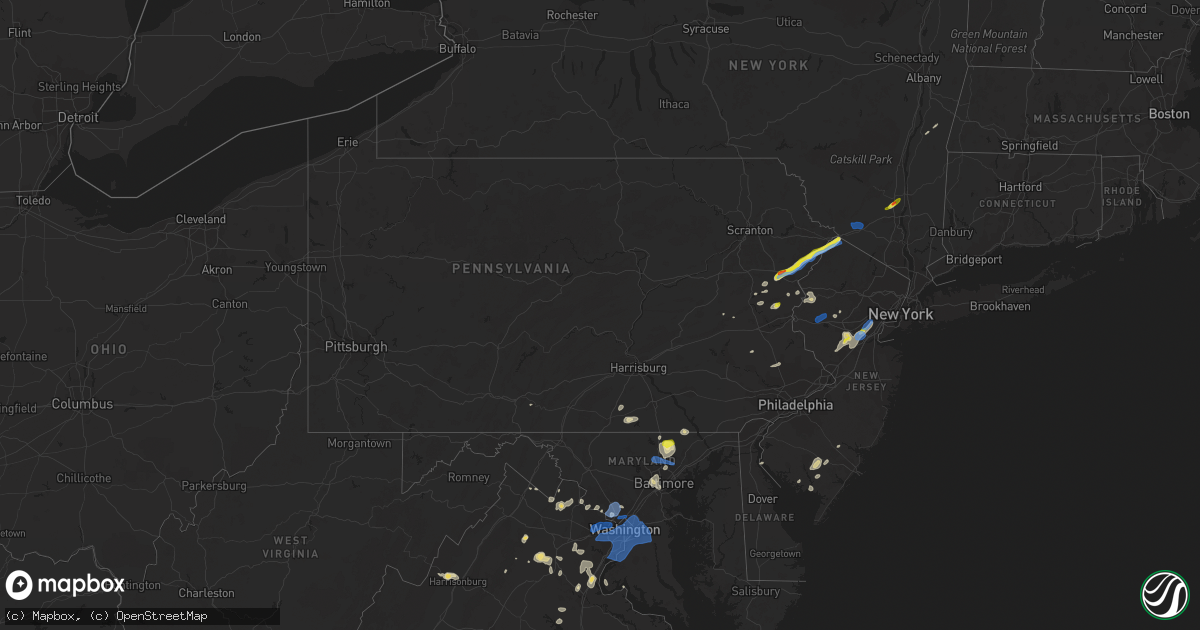
Hail Map in Pennsylvania on July 22, 2020
Get this storm
July 22 map
$229
one time, instant access
Download today. No call, no setup
Keep the $229
Bought the map and want the full workflow? Apply the entire $229 to a subscription within 7 days. None of it is wasted.
Every map, not just this one
This buys you this map. Subscription and you get every map we run, in the markets you choose from a few cities to whole states to nationwide. Plus real-time alerts the moment a storm fires.
Contact data
Name, contact info, occupancy, even credit band for addresses in the footprint. You go from where it hit to who to call.
Become the source they trust
Unlimited branding weather history reports on demand. You already have the documented answer ready for the property owner, and you are the one who showed up with it.
Property data and RoofTrace estimates
Pull up any address you have got, its value and the exact code rules for that jurisdiction, straight from One Click Code. Then RoofTrace estimates the squares, pitch, and roof value, priced the way you price.
Storm reports in Pennsylvania
Pennsylvania
| Date | Description |
|---|---|
| 07/22/20205:11 PM CDT | Tree and/or wires down on moredon rd at old ford rd. Time estimated from radar. |
| 07/22/20205:02 PM CDT | Downed trees and wires near maddock road and river road in washington crossing. Time estimated from radar. |
| 07/22/20205:02 PM CDT | Downed tree near the interstate 76 and montgomery drive interchange. Time estimated from radar. |
| 07/22/20204:57 PM CDT | Several reports of wires down in the jamison area. Time estimated from radar. |
| 07/22/20204:54 PM CDT | Tree and/or wires down on w pennsylvania ave. Time estimated from radar. |
| 07/22/20204:37 PM CDT | Tree and/or wires down on mclaughlin rd at country club dr near the pinecrest golf club. Time estimated from radar. |
| 07/22/20204:34 PM CDT | Downed tree limbs and wires near mountain view road near quakertown. Time estimated from radar. |
| 07/22/20204:32 PM CDT | 8 inch diameter maple branch snapped off tree in chalfont. |
| 07/22/20204:28 PM CDT | Several reports of wires down between white horse and perkasie. Time estimated from radar. |
| 07/22/20204:25 PM CDT | Downed wires near leon drive in hatfield. Time estimated from radar. |
| 07/22/20204:25 PM CDT | Downed trees and wires near schukraft road in west rockhill twp. Time estimated from radar. |
| 07/22/20204:22 PM CDT | Tree and/or wires down on valley creek rd at harmony hill rd. Time estimated from radar. |
| 07/22/20204:22 PM CDT | Tree and/or wires down on college ave at 3rd ave. Time estimated from radar. |
| 07/22/20204:21 PM CDT | Downed wires near heiden road in mount bethel. Time estimated from radar. |
| 07/22/20204:21 PM CDT | Downed utility on u.s. Highway 30 near planebrook road. Time estimated from radar. |
| 07/22/20204:16 PM CDT | Downed wires near northwood avenue in easton. Time estimated from radar. |
| 07/22/20204:13 PM CDT | Downed trees and wires near bangor road in plainfield twp. Time estimated from radar. |
| 07/22/20204:11 PM CDT | Downed wires near court street in allentown. Time estimated from radar. |
| 07/22/20204:11 PM CDT | Downed wires near walnut street in emmaus. Time estimated from radar. |
| 07/22/20204:11 PM CDT | Downed wires near center street in nazareth. Time estimated from radar. |
| 07/22/20204:08 PM CDT | Several reports of trees and wires down south of wind gap. Time estimated from radar. |
| 07/22/20204:06 PM CDT | Downed wires near clover street in north catasauqua. Time estimated from radar. |
| 07/22/20204:01 PM CDT | Downed trees and wires near lapp road in stetlersville. Time estimated from radar. |
| 07/22/20204:01 PM CDT | Downed wires near hopewell road near the berks/chester county border. Time estimated from radar. |
| 07/22/20203:59 PM CDT | Downed trees and wires near saylorsburg. Time estimated from radar. |
| 07/22/20203:56 PM CDT | Downed trees and wires near kunkletown road in kunkletown. Time estimated from radar. |
| 07/22/20203:54 PM CDT | Downed trees and wires near gould road in brodheadsville. Time estimated from radar. |
| 07/22/20203:54 PM CDT | Downed tree and wires near arrowhead lane near breinigsville. Time estimated from radar. |
| 07/22/20203:53 PM CDT | Tree down on wires with transformer blown on anthonys mill rd. Time estimated from radar. |
| 07/22/20203:51 PM CDT | Downed trees and wires near west philadelphia avenue in earl twp. Time estimated from radar. |
| 07/22/20203:51 PM CDT | Downed trees and wires near wabasso avenue in delps. Time estimated from radar. |
| 07/22/20203:51 PM CDT | Several reports of trees and wires down west of belfast in the bushkill twp area... With numerous power outages and a few road closures in the area. Time estimated from |
| 07/22/20203:51 PM CDT | Downed trees and wires near bushkill drive in bushkill twp. Time estimated from radar. |
| 07/22/20203:51 PM CDT | Tree down on shed road in union twp. Time estimated from radar. |
| 07/22/20203:49 PM CDT | Downed wires on seipstown road in seipstown. Time estimated from radar. |
| 07/22/20203:34 PM CDT | Downed wires on ledge rock road east of mohnton. Time estimated from radar. |
| 07/22/20203:33 PM CDT | Downed tree in wires on hollywood dr. Time estimated from radar. |
| 07/22/20203:32 PM CDT | Downed wires on wyomissing avenue in mohnton. Time estimated from radar. |
| 07/22/20203:30 PM CDT | Downed tree on moselem springs rd. Time estimated from radar. |
| 07/22/20203:29 PM CDT | Downed trees and wires near swamp hollow road in washington twp. Time estimated from radar. |
| 07/22/20203:28 PM CDT | Downed trees and wires near bake oven road in east penn twp. Time estimated from radar. |
| 07/22/20203:26 PM CDT | Downed tree on route 863 near kistler valley road. Time estimated from radar. |
| 07/22/20203:17 PM CDT | Downed wires near state street in west hamburg. Time estimated from radar. |
| 07/22/20203:10 PM CDT | Trees and wires down on woodbine road between cherry road and poplar ridge road. |
| 07/22/20203:03 PM CDT | Several reports of trees and wires down in the host and north heidelberg areas. Time estimated from radar. |
| 07/22/20203:03 PM CDT | Multiple trees and wires reported down along line road at delta road and hushon road. |
| 07/22/20203:01 PM CDT | Several reports of trees and wires down in stouchsburg. Time estimated from radar. |
| 07/22/20202:00 PM CDT | Multiple trees down on a house along with wires down in the area |
| 07/22/20201:55 PM CDT | Two poles down in delaware township |
| 07/22/20201:52 PM CDT | Tree down on a house |
| 07/22/20201:30 PM CDT | Tree down on a vehicle on brush dr. Time estimated from radar. |
| 07/22/20201:29 PM CDT | Tree down on wires on schoolhouse rd. Time estimated from radar. |
| 07/22/20201:25 PM CDT | A downed tree blocked paradise trail by penn hills. Time estimated from radar. |
| 07/22/20201:24 PM CDT | Downed tree in the roadway on cherry lane rd at birchwood rd. Time estimated from radar. |
| 07/22/20201:18 PM CDT | Tree down blocking scotrun ave. Time estimated from radar. |
| 07/22/20201:17 PM CDT | Downed trees and wires near scotrun avenue. Time estimated from radar. |
| 07/22/20201:17 PM CDT | Several trees and wires were downed on camelback rd. Time estimated from radar. |
| 07/22/20201:16 PM CDT | Two trees downed blocking sullivan trail by barkley creek. Time estimated from radar. |
| 07/22/20201:13 PM CDT | Social media video of hail at least ping pong ball sized in tannersville. Time estimated from radar. |
| 07/22/20201:11 PM CDT | Tree down on route 115 at brookmont dr. Time estimated from radar. |
| 07/22/202012:46 PM CDT | Trees and wires down. Reported along the line between hanover and spring grove. |
| 07/22/20201:17 AM CDT | At 617 PM EDT, severe thunderstorms were located along a line extending from near Somerset to Burlington, moving east at 20 mph. HAZARD...60 mph wind gusts. SOURCE...Radar indicated. IMPACT...Damage to roofs, siding, trees, and power lines is possible. Locations impacted include... Toms River, New Brunswick, Perth Amboy, Long Branch, Asbury Park, Sandy Hook, Somerset, Edison, Lakewood, Middletown, Old Bridge, Jackson, Howell, East Brunswick, South Brunswick, Sayreville, North Brunswick, Marlboro, Manalapan and Tinton Falls.This includes the following highways... New Jersey Turnpike between exits 7 and 12. Interstate 195 in New Jersey between mile markers 0 and 34. Interstate 295 in New Jersey between mile markers 52 and 67. Interstate 287 in New Jersey between mile markers 0 and 4, andbetween mile markers 9 and 12. Garden State Parkway between mile markers 86 and 130. |
| 07/22/202012:40 AM CDT | At 539 PM EDT, a severe thunderstorm was located over Chalfont, or 18 miles north of Philadelphia, moving east at 30 mph. HAZARD...60 mph wind gusts. SOURCE...Law enforcement. Several reports of trees down have been received in Montgomery County with these storms. IMPACT...Damage to roofs, siding, trees, and power lines is possible. Locations impacted include... Philadelphia, Trenton, Bensalem, Ewing, Willingboro, Princeton, Florence, Manville, Burlington, Bristol, Doylestown, Byram, Riverside, Palmyra, Hatboro, Flemington, Jenkintown, Tinicum, Bordentown and Pennington.This includes the following highways... New Jersey Turnpike between exits 5 and 7A. Pennsylvania Turnpike between mile markers 338 and 359. Interstate 95 in Pennsylvania between mile markers 28 and 40. Interstate 76 in Pennsylvania between mile markers 338 and 339. Interstate 195 in New Jersey between mile markers 0 and 3. Interstate 295 in New Jersey between mile markers 46 and 76. |
| 07/22/202012:09 AM CDT | At 508 PM EDT, severe thunderstorms were located along a line extending from Zionsville to near Chester Springs, moving east at 25 mph. HAZARD...70 mph wind gusts and penny size hail. SOURCE...Law enforcement. These storms have produced wind damage in Lehigh and Berks Counties. IMPACT...Expect considerable tree damage. Damage is likely to mobile homes, roofs, and outbuildings. Locations impacted include... Philadelphia, Norristown, Pottstown, Phoenixville, Lansdale, West Norriton, East Norriton, Emmaus, Quakertown, Perkasie, Doylestown, Downingtown, Conshohocken, Souderton, Bedminster, Ambler, Collegeville, Royersford, Narberth and Chalfont.This includes the following highways... Pennsylvania Turnpike between mile markers 308 and 339. Northeast Extension between mile markers 21 and 53. Interstate 76 in Pennsylvania between mile markers 327 and 339. Interstate 476 in Pennsylvania between mile markers 12 and 19. |
| 07/21/202011:25 PM CDT | At 424 PM EDT, a severe thunderstorm was located over Wyomissing, or near Reading, moving east at 40 mph. HAZARD...60 mph wind gusts and nickel size hail. SOURCE...Radar indicated. IMPACT...Damage to roofs, siding, trees, and power lines is possible. Locations impacted include... Reading, Pottstown, Phoenixville, Wyomissing, Quakertown, Birdsboro, Collegeville, Royersford, Fleetwood, Sinking Spring, Laureldale, Trappe, East Greenville, Wernersville, Leesport, Schwenksville, Shoemakersville, Elverson, Bally and Bechtelsville.This includes the following highways... Pennsylvania Turnpike between mile markers 296 and 303. Northeast Extension between mile markers 34 and 46. Interstate 176 in Pennsylvania between mile markers 1 and 11. |
| 07/21/202011:10 PM CDT | At 409 PM EDT, severe thunderstorms were located along a line extending from Lehighton to near Hamburg, moving east at 15 mph. HAZARD...60 mph wind gusts and quarter size hail. SOURCE...Radar indicated. IMPACT...Minor damage to vehicles is possible. Wind damage to roofs, siding, trees, and power lines is possible. Locations impacted include... Allentown, Lehighton, Northampton, Palmerton, Kutztown, Jim Thorpe, Hamburg, Slatington, Bath, Walnutport, Topton, Shoemakersville, Lyons, Lenhartsville, New Mahoning, Neffs, Coffeetown, New Tripoli, Berlinsville and Emerald.This includes the following highways... Northeast Extension between mile markers 57 and 79. Interstate 78 in Pennsylvania between mile markers 26 and 54. |
| 07/21/202010:50 PM CDT | At 349 PM EDT, a severe thunderstorm was located over Great Meadows-Vienna, or 17 miles southwest of Newton, moving east at 25 mph. HAZARD...70 mph wind gusts and quarter size hail. SOURCE...Radar indicated. IMPACT...Minor damage to vehicles is possible. Expect considerable tree damage. Wind damage is also likely to mobile homes, roofs, and outbuildings. Locations impacted include... Hopatcong, Hackettstown, Wharton, Washington, Mount Arlington, Stanhope, Netcong, Belvidere, Harmony, Oxford, Glen Gardner, Chester, Hampton, Califon, Brass Castle, Long Valley, Great Meadows-Vienna, Allamuchy-Panther Valley, Succasunna and Pleasant Valley.This includes Interstate 80 in New Jersey between mile markers 17 and33. |
| 07/21/202010:39 PM CDT | At 338 PM EDT, a severe thunderstorm was located over Fredericksburg, or near Lebanon, moving east at 25 mph. HAZARD...60 mph wind gusts and nickel size hail. SOURCE...Radar indicated. IMPACT...Damage to roofs, siding, trees, and power lines is possible. Locations impacted include... Wyomissing, Sinking Spring, Womelsdorf, Wernersville, Robesonia, Bernville, Strausstown, Fairview Hgts, Spring Ridge, West Lawn, Whitfield, West Wyomissing and Wyomissing Hills.This includes Interstate 78 in Pennsylvania between mile markers 10and 29. |
| 07/21/202010:27 PM CDT | At 318 PM EDT, a severe thunderstorm was located over High Point, or near Matamoras, moving northeast at 50 mph. HAZARD...60 mph wind gusts and quarter size hail. SOURCE...Radar indicated. IMPACT...Minor hail damage to vehicles is possible. Expect wind damage to trees and power lines. This severe thunderstorm will be near... Middletown around 335 PM EDT. Goshen and Chester around 340 PM EDT. Walden and Montgomery around 350 PM EDT. Gardnertown around 400 PM EDT. Newburgh around 405 PM EDT. |
| 07/21/202010:04 PM CDT | At 303 PM EDT, a severe thunderstorm was located over Dingmans Ferry, or 7 miles southwest of Montague, moving northeast at 30 mph. HAZARD...70 mph wind gusts and quarter size hail. SOURCE...Radar indicated. IMPACT...Minor damage to vehicles is possible. Expect considerable tree damage. Wind damage is also likely to mobile homes, roofs, and outbuildings. Locations impacted include... Montague, Sussex, Branchville, High Point, Crandon Lakes, Vernon Valley and Hainesville. |
| 07/21/20209:09 PM CDT | At 209 PM EDT, a severe thunderstorm was located over McConnellsburg, moving east at 25 mph. HAZARD...60 mph wind gusts. SOURCE...Radar indicated. IMPACT...Expect damage to trees, roofs, and siding. Locations impacted include... Chambersburg, Shippensburg, Guilford, St. Thomas, Fayetteville, Scotland, McConnellsburg, Harrisonville, Marion, Fort Loudon, Roxbury, Upper Strasburg, Fannettsburg and Orrstown.This includes Interstate 81 from mile markers 11 to 25. |
All States Impacted by Hail Map on July 22, 2020
Cities Impacted by Hail Map on July 22, 2020
- Sonora, TX
- Beresford, SD
- Lennox, SD
- Truckee, CA
- Sugar Grove, WV
- Fort Jones, CA
- Yreka, CA
- Nashville, TN
- Hermitage, TN
- Wallkill, NY
- Post, TX
- Vineland, NJ
- Milmay, NJ
- Richland, NJ
- Cheyenne, WY
- Sterling, VA
- Ashburn, VA
- Poolesville, MD
- Bedford, KY
- Portal, ND
- Flaxton, ND
- Amissville, VA
- Rixeyville, VA
- Marshall, VA
- Warrenton, VA
- Jeffersonton, VA
- Remington, VA
- Odonnell, TX
- McLaughlin, SD
- McIntosh, SD
- Buena Vista, VA
- Lexington, VA
- Wildorado, TX
- Midland, VA
- Newport, NJ
- Sierraville, CA
- Eagle Butte, SD
- Stamford, TX
- Isabel, SD
- Blunt, SD
- Agar, SD
- Timber Lake, SD
- Onida, SD
- Ridgeview, SD
- Pierre, SD
- Sylvester, TX
- Markleeville, CA
- Afton, VA
- North Brunswick, NJ
- Somerville, NJ
- Clark, NJ
- Colonia, NJ
- Hillsborough, NJ
- South Plainfield, NJ
- Scotch Plains, NJ
- Westfield, NJ
- Belle Mead, NJ
- Manville, NJ
- New Brunswick, NJ
- Highland Park, NJ
- Raritan, NJ
- Piscataway, NJ
- Cranford, NJ
- Garwood, NJ
- Franklin Park, NJ
- Kendall Park, NJ
- Skillman, NJ
- Edison, NJ
- Bridgewater, NJ
- Somerset, NJ
- Rockville, MD
- Silver Spring, MD
- Centerville, SD
- Montague, NJ
- Branchville, NJ
- Hudson, NY
- Burnsville, MS
- Corinth, MS
- Glen, MS
- Junction, IL
- Shawneetown, IL
- Front Royal, VA
- Huntly, VA
- Chester Gap, VA
- Hume, VA
- Linden, VA
- Stafford, VA
- Partlow, VA
- Bumpass, VA
- Spotsylvania, VA
- Rocksprings, TX
- Quantico, VA
- Triangle, VA
- Harrisonburg, VA
- Potomac, MD
- Germantown, MD
- Plainview, TX
- Pen Argyl, PA
- Bangor, PA
- Purcellville, VA
- Shepherdsville, KY
- Brooks, KY
- Louisville, KY
- Elkton, KY
- Sharon Grove, KY
- Hopkinsville, KY
- Troutdale, VA
- Montague, CA
- Lewiston, CA
- Ghent, NY
- Bethesda, MD
- Syria, VA
- Florence, AL
- Millville, NJ
- Buena, NJ
- Hinton, VA
- Hollowville, NY
- Claverack, NY
- Hext, TX
- Lignite, ND
- Westport, KY
- La Grange, KY
- Hayesville, NC
- Buchanan, GA
- Tallapoosa, GA
- Lehighton, PA
- Halethorpe, MD
- Catonsville, MD
- Brooklyn, MD
- Baltimore, MD
- Gwynn Oak, MD
- Windsor Mill, MD
- Middletown, DE
- Tannersville, PA
- East Stroudsburg, PA
- Stroudsburg, PA
- Bartonsville, PA
- Henryville, PA
- Layton, NJ
- Bushkill, PA
- Tamiment, PA
- Dingmans Ferry, PA
- Brandy Station, VA
- Elkwood, VA
- White Hall, MD
- Jarrettsville, MD
- Monkton, MD
- Louisa, VA
- Mount Pleasant, TN
- Slaton, TX
- Eldorado, TX
- Chancellor, SD
- Galax, VA
- Fries, VA
- Dayton, VA
- Ararat, VA
- New Tripoli, PA
- Douglas City, CA
- Paeonian Springs, VA
- Round Hill, VA
- Leesburg, VA
- Hamilton, VA
- Fallston, MD
- Phoenix, MD
- Hamlin, TX
- Salem, NJ
- Oneonta, AL
- Sweetwater, TX
- Oxford, NJ
- Great Meadows, NJ
- Belvidere, NJ
- Columbia, NJ
- Blairstown, NJ
- East Berlin, PA
- New Oxford, PA
- Kress, TX
- Kunkletown, PA
- Kresgeville, PA
- Gilbert, PA
- Minden, NV
- Nazareth, PA
- Bath, PA
- Hereford, TX
- Vega, TX
- Mcarthur, CA
- Spring Grove, PA
- Hanover, PA
- Leesburg, NJ
- Heislerville, NJ
- Junction, TX
- London, TX
- Mays Landing, NJ
- Littlefield, TX
- Menard, TX
- Buffalo, WY
- Burns, WY
- Rochester, TX
- Whiteford, MD
- Fawn Grove, PA
- Pylesville, MD
- Delta, PA
- Roseland, VA
- Charlottesville, VA
- Augusta, WV
- Delray, WV
- Janesville, CA
- Hillsdale, NY
- Lutherville Timonium, MD
- Towson, MD
- Statesboro, GA
- Fredericksburg, VA
- Highland, NY
- Manassas, VA
- Floyds Knobs, IN
- Sellersburg, IN
- Trinity Center, CA
- Bristow, VA
- Nokesville, VA
- Junction City, CA
- Ardmore, TN
- Justiceburg, TX
- Millwood, GA
- Manor, GA
- Iuka, MS
- McSherrystown, PA
- Muscadine, AL
- Palmerton, PA
- Walnutport, PA
- Danielsville, PA
- Capon Bridge, WV
- Harpers Ferry, WV
- Bluemont, VA
- Lyndhurst, VA
- Columbia, TN
- Dickerson, MD
- Barto, PA
- Bechtelsville, PA
- Dixon, KY
- Boulder, UT
- Cave In Rock, IL
- Ridgway, IL
- Portland, TN
- Gallatin, TN
- Sumerduck, VA
- Bealeton, VA
- Eddyville, KY
- Cadiz, KY
- Princeton, KY
- King George, VA
- Hale Center, TX
- Summit Point, WV
- Berryville, VA
- Rutherfordton, NC
- Lake Lure, NC
- New Ringgold, PA
- Castleton, VA
- Jasper, IN
- Nanjemoy, MD
- Sperryville, VA
- Scotrun, PA
- Yellow Spring, WV
- Hillsville, VA
- Fancy Gap, VA
- Petersburg, WV
- Charlotte, NC
- Matthews, NC
- Far Hills, NJ
- Gladstone, NJ
- Shelbyville, TN
- Hammonton, NJ
- Hillsdale, WY
- Ralls, TX
- Crosbyton, TX
- Baldwin, MD
- McConnellsburg, PA
- Effort, PA
- Sparks Glencoe, MD
- Parkton, MD
- Ware, MA
- Belchertown, MA
- Palmer, MA
- Parker, SD
- Hurley, SD
- Califon, NJ
- Stephenson, VA
- Clear Brook, VA
- Axson, GA
- Cottontown, TN
- Mount Bethel, PA
- Almo, KY
- Murray, KY
- Pendleton, KY
- Sikeston, MO
- Canyon, TX
- Ovando, MT
- Prospect, TN
- Orlinda, TN
- Cross Plains, TN
- Cherokee, AL
- Harleysville, PA
- Souderton, PA
- Schwenksville, PA
- Fisherville, KY
- Simpsonville, KY
- Walden, NY
- Marlboro, NY
- Milton, NY
- Macdoel, CA
- Weaverville, CA
- Wind Gap, PA
- Vienna, VA
- Herndon, VA
- Fairfax, VA
- Reston, VA
- McLean, VA
- Great Falls, VA
- Falls Church, VA
- Oakton, VA
- Lanham, MD
- Bryans Road, MD
- Capitol Heights, MD
- Hyattsville, MD
- Temple Hills, MD
- Burke, VA
- Fort Myer, VA
- Fort Belvoir, VA
- Lorton, VA
- Accokeek, MD
- Oxon Hill, MD
- Andrews Air Force Base, MD
- Riverdale, MD
- Indian Head, MD
- College Park, MD
- Brentwood, MD
- Annandale, VA
- Arlington, VA
- Bowie, MD
- Takoma Park, MD
- Springfield, VA
- Washington, DC
- Greenbelt, MD
- Upper Marlboro, MD
- Clinton, MD
- Fairfax Station, VA
- Bladensburg, MD
- Suitland, MD
- District Heights, MD
- Mount Rainier, MD
- Alexandria, VA
- Fort Washington, MD
- Naval Anacost Annex, DC
- Kensington, MD
- Garrett Park, MD
- Derwood, MD
- Chevy Chase, MD
- Reisterstown, MD
- Hunt Valley, MD
- Glen Arm, MD
- Cockeysville, MD
- Street, MD
- Sussex, NJ
- Otisville, NY
- Middletown, NY
- Glen Gardner, NJ
- Clinton, NJ
- High Bridge, NJ
- Hampton, NJ
- Lebanon, NJ
- Annandale, NJ
- Fanwood, NJ
- Plainfield, NJ


