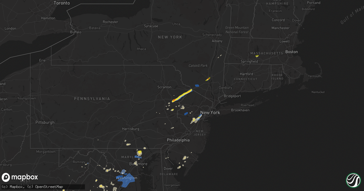
Hail Map on July 22, 2020
Get this storm
July 22 map
$229
one time, instant access
Download today. No call, no setup
Keep the $229
Bought the map and want the full workflow? Apply the entire $229 to a subscription within 7 days. None of it is wasted.
Every map, not just this one
This buys you this map. Subscription and you get every map we run, in the markets you choose from a few cities to whole states to nationwide. Plus real-time alerts the moment a storm fires.
Contact data
Name, contact info, occupancy, even credit band for addresses in the footprint. You go from where it hit to who to call.
Become the source they trust
Unlimited branding weather history reports on demand. You already have the documented answer ready for the property owner, and you are the one who showed up with it.
Property data and RoofTrace estimates
Pull up any address you have got, its value and the exact code rules for that jurisdiction, straight from One Click Code. Then RoofTrace estimates the squares, pitch, and roof value, priced the way you price.
States Impacted by Hail Map on July 22, 2020
Storm reports
Massachusetts
| Date | Description |
|---|---|
| 07/22/20206:41 PM CDT | Tree down on wires on school st in hardwick. |
| 07/22/20206:35 PM CDT | Wires downed on checkered lane in west brookfield. |
| 07/22/20206:30 PM CDT | Several large tree branches downed on pulaski st in ware. |
| 07/22/20206:26 PM CDT | Tree and wires downed blocking part of polpuit hill rd in amherst. |
| 07/22/20206:10 PM CDT | Trees and wires downed on south maple st in hadley. |
| 07/22/20206:10 PM CDT | Trees and wires downed on north lane in hadley. |
| 07/22/20205:56 PM CDT | Trees and wires downed on chestnut st in northampton. |
| 07/22/20205:56 PM CDT | Trees and powerlines downed on ryan rd in northampton. |
| 07/22/20201:51 AM CDT | At 650 PM EDT, a severe thunderstorm was located over Ludlow, or 8 miles east of Chicopee, moving northeast at 20 mph. HAZARD...60 mph wind gusts and quarter size hail. SOURCE...Radar indicated. IMPACT...Expect wind damage to trees and power lines. Minor hail damage to vehicles is possible. Locations impacted include... Chicopee, Ludlow, South Hadley, Belchertown, Wilbraham, Palmer, Spencer, Ware, Monson, Granby, Barre, Hampden, Warren, North Brookfield, West Brookfield, Brimfield, Brookfield, Hardwick, Oakham and Pelham. |
| 07/22/20201:30 AM CDT | At 629 PM EDT, a severe thunderstorm was located near Williamsburg, or near Northampton, moving east at 25 mph. HAZARD...60 mph wind gusts and quarter size hail. SOURCE...Radar indicated. IMPACT...Expect wind damage to trees and power lines. Minor hail damage to vehicles is possible. Locations impacted include... Amherst, Northampton, Orange, Deerfield, Belchertown, Athol, Ware, Barre, Hadley, Sunderland, Hatfield, Hardwick, Williamsburg, Huntington, Conway, Leverett, Shutesbury, Phillipston, Westhampton and Whately. |
Delaware
| Date | Description |
|---|---|
| 07/22/20205:47 PM CDT | Downed tree and power lines reported in long neck. Time estimated from radar. |
| 07/22/20205:28 PM CDT | Downed tree and wires near milton-ellendale highway in milton. Time estimated from radar. |
| 07/22/20205:26 PM CDT | Downed tree and wires near hickory ridge road in cheswold. Time estimated from radar. |
| 07/22/20201:12 AM CDT | At 612 PM EDT, severe thunderstorms were located along a line extending from near Holmesburg to National Park to near Saint Georges, moving east at 20 mph. HAZARD...60 mph wind gusts and penny size hail. SOURCE...Radar indicated. IMPACT...Damage to roofs, siding, trees, and power lines is possible. Locations impacted include... Philadelphia, Camden, Wilmington, Gloucester City, Cherry Hill, Evesham, Mount Laurel, Willingboro, Deptford, Voorhees, Medford, West Deptford, Glassboro, Lindenwold, Pennsville, Lumberton, Florence, Bellmawr, Woodbury and Burlington.This includes the following highways... New Jersey Turnpike between exits 1 and 7A. Pennsylvania Turnpike near mile marker 359. Interstate 76 in New Jersey between mile markers 0 and 3. Interstate 295 in New Jersey between mile markers 0 and 56. Interstate 676 in New Jersey between mile markers 0 and 4. Atlantic City Expressway between mile markers 41 and 44. |
| 07/22/202012:23 AM CDT | At 523 PM EDT, severe thunderstorms were located along a line extending from near Centreville to Easton to near University Of Maryland Center For Environmental Studies, moving east at 35 mph. HAZARD...60 mph wind gusts and penny size hail. SOURCE...Radar indicated. IMPACT...Damage to roofs, siding, trees, and power lines is possible. Locations impacted include... Easton, Centerville, Denton, Centreville, Harrington, Federalsburg, Greensboro, Oakland, Ridgely, Trappe, Preston, Sudlersville, Goldsboro, Queen Anne, Hartly, Smithville, Starr, Jumptown, Hazlettville and Agner. |
| 07/22/202012:13 AM CDT | At 512 PM EDT, severe thunderstorms were located along a line extending from near Havre De Grace to near Bowleys Quarters to Severna Park, moving east at 35 mph. HAZARD...60 mph wind gusts and nickel size hail. SOURCE...Radar indicated. IMPACT...Damage to roofs, siding, trees, and power lines is possible. Locations impacted include... Elkton, Chestertown, Centreville, North East, Rock Hall, Charlestown, Church Hill, Cecilton, Betterton, Warwick, Old Town, Grasonville, Bohemias Mills, Newtown, Brantwood, Morgnec, Crumpton, Bay View, Sassafras and Stevensville.This includes the following highways... Interstate 95 in Delaware near mile marker 0. Interstate 95 in Maryland between mile markers 91 and 109. |
South Carolina
| Date | Description |
|---|---|
| 07/22/20204:05 PM CDT | A tree down near lake cooley on facebook. Time estimated by radar. |
| 07/22/20201:45 AM CDT | At 644 PM EDT, a severe thunderstorm was located 9 miles east of Greenville Downtown, or near GSP Airport, moving southwest at 10 mph. HAZARD...60 mph wind gusts and penny size hail. SOURCE...Radar indicated. IMPACT...Expect damage to trees and power lines. Locations impacted include... Greenville Downtown, Greenville Eastside, West Greenville, Greer, Mauldin, Taylors, Simpsonville, Five Forks, Duncan and Reidville. |
| 07/21/20209:20 PM CDT | At 220 PM EDT, a severe thunderstorm was located 4 miles southeast of Hendersonville, or near Flat Rock, moving northeast at 15 mph. HAZARD...60 mph wind gusts and quarter size hail. SOURCE...Radar indicated. IMPACT...Minor hail damage to vehicles is expected. Expect wind damage to trees and power lines. Locations impacted include... Hendersonville, Columbus, Flat Rock, Laurel Park, Lake Lure, Saluda, Chimney Rock Village, Chimney Rock State Park, Bat Cave and Valley Hill. |
Kentucky
| Date | Description |
|---|---|
| 07/22/20203:50 PM CDT | Delayed report. Social media report of large tree down across glen lily rd at the 5500 block. Time estimated from radar. |
| 07/22/20201:13 AM CDT | At 612 PM EDT, severe thunderstorms were located from near Highview to near Pioneer Village, moving east at 30 mph. HAZARD...60 mph wind gusts. SOURCE...Radar indicated. IMPACT...Expect damage to roofs, siding, and trees. Locations impacted include... Jeffersontown, Middletown, Pioneer Village, Hollow Creek, Spring Mill, Highview, Fern Creek, Okolona, Minor Lane Heights, and Mount Washington. |
| 07/21/202010:25 PM CDT | At 325 PM EDT, a severe thunderstorm was located near Lucasville, moving east at 20 mph. HAZARD...60 mph wind gusts. SOURCE...Radar indicated. IMPACT...Expect damage to trees and power lines. Locations impacted include... Portsmouth, Wheelersburg, New Boston, South Webster, Rosemount, Clarktown, Lucasville, Sciotodale, Beaver, Wakefield, Lombardsville, Stockdale, Minford, West Portsmouth, Sciotoville, State Route 335 at State Route 776, Turkey Creek Lake, Givens, Mcdermott and Portsmouth Regional Airport. |
| 07/21/202010:08 PM CDT | At 307 PM CDT, a severe thunderstorm was located 10 miles east of Dunmor, moving northeast at 35 mph. HAZARD...60 mph wind gusts and penny size hail. SOURCE...Radar indicated. IMPACT...Expect damage to roofs, siding, and trees. Locations impacted include... Morgantown, Casey, Woodbury, Monford, Huntsville, Mining City, Dimple, Aberdeen, Leetown and Eden. |
| 07/21/20209:52 PM CDT | At 252 AM EDT, a severe thunderstorm was located over Georgetown, moving northeast at 45 mph. HAZARD...60 mph wind gusts and quarter size hail. SOURCE...Radar indicated. IMPACT...Minor hail damage to vehicles is possible. Expect wind damage to trees and power lines. Locations impacted include... Georgetown, Mount Orab, Ripley, Winchester, Sardinia, Seaman, Emerald, Decatur, Russellville, Hamersville, Mowrystown, Higginsport, Cherry Fork, Redoak, Danville in Highland County, Lake Waynoka, Buford, Feesburg, Fincastle and State Route 32 at US Route 62. |
| 07/21/20209:41 PM CDT | At 241 PM CDT, a severe thunderstorm was located 8 miles southwest of Dunmor, moving northeast at 25 mph. HAZARD...60 mph wind gusts and quarter size hail. SOURCE...Radar indicated. IMPACT...Hail damage to vehicles is expected. Expect wind damage to roofs, siding, and trees. Locations impacted include... Anderson, Lewisburg, Justice, Cooperstown, Insco, Huntsville, Spa, Epleys, Diamond Springs and Wolf Lick. |
District of Columbia
| Date | Description |
|---|---|
| 07/22/20203:35 PM CDT | A local report indicates 63 MPH wind near 1 WSW CATHOLIC UNIVERSI |
| 07/22/20202:59 PM CDT | Numerous large trees and branches down near downtown dc... Including a large tree on a car near the intersection of c street southeast and pennsylvania avenue southeast |
| 07/22/20202:54 PM CDT | A local report indicates 58 MPH wind near REAGAN NATIONAL ARPT |
| 07/22/20202:53 PM CDT | 55 knot wind gust from sensor at childrens hospital |
| 07/21/202010:17 PM CDT | At 316 PM EDT, severe thunderstorms were located along a line extending from near Potomac to near Linton Hall, moving east at 25 mph. HAZARD...Damaging wind gusts up to 65 mph and isolated hail up to quarter size. SOURCE...Radar indicated. IMPACT...Damaging winds will cause some trees and large branches to fall. This could injure those outdoors, as well as damage homes and vehicles. Roadways may become blocked by downed trees. Localized power outages are possible. Unsecured light objects may become projectiles. Locations impacted include... Arlington, Alexandria, Bethesda, Bowie, Annandale, Clinton, Springfield, College Park, Fort Washington, Greenbelt, Fairfax, Langley Park, Beltsville, Fort Hunt, Vienna, Groveton, Forestville, Falls Church, Huntington and Coral Hills. |
| 07/21/20209:56 PM CDT | At 256 PM EDT, severe thunderstorms were located along a line extending from near Poolesville to Brambleton to near Haymarket to near Warrenton, moving east at 10 mph. HAZARD...Scattered damaging wind gusts up to 60 mph and isolated hail up to quarter size. SOURCE...Radar indicated. IMPACT...Damaging winds will cause some trees and large branches to fall. This could injure those outdoors, as well as damage homes and vehicles. Roadways may become blocked by downed trees. Localized power outages are possible. Unsecured light objects may become projectiles. Locations impacted include... Arlington, Germantown, Centreville, Rockville, Bethesda, Gaithersburg, Reston, Annandale, Olney, Herndon, Fairfax, Vienna, Damascus, Falls Church, Lowes Island, Mantua, Pimmit Hills, Mclean, American Legion Bridge and Aspen Hill. |
Ohio
| Date | Description |
|---|---|
| 07/22/20202:29 PM CDT | Multiple small trees down across mccorkle rd. |
| 07/21/202011:58 PM CDT | At 458 PM EDT, a severe thunderstorm was located over Ceredo, or near Chesapeake, moving east at 30 mph. HAZARD...60 mph wind gusts. SOURCE...Radar indicated. IMPACT...Expect damage to roofs, siding, and trees. Locations impacted include... Huntington, Ashland, Coal Grove, Wayne, Chesapeake, Proctorville, Beech Fork State Park, Barboursville, Kenova, Catlettsburg, Ceredo, Ona, Burnaugh, Durbin, Centerville, South Point, Burlington, Athalia, Lockwood and Salt Rock.This includes the following highways... Interstate 64 in Kentucky between mile markers 186 and 191. Interstate 64 in West Virginia between mile markers 1 and 25. |
South Dakota
| Date | Description |
|---|---|
| 07/22/20208:55 AM CDT | A local report indicates 1.00 inch wind near 4 W ONIDA |
| 07/22/20204:46 AM CDT | At 945 AM CDT/845 AM MDT/, a severe thunderstorm was located 10 miles north of Little Bend Rec Area, or 29 miles northwest of Onida, moving southeast at 20 mph. HAZARD...Ping pong ball size hail and 60 mph wind gusts. SOURCE...Radar indicated. IMPACT...People and animals outdoors will be injured. Expect hail damage to roofs, siding, windows, and vehicles. Expect wind damage to roofs, siding, and trees. Locations impacted include... Bush'S Landing, Sutton Bay Rec Area, Little Bend Rec Area and Lake Oahe. |
| 07/22/20204:38 AM CDT | At 937 AM CDT, a severe thunderstorm was located near Onida, moving east at 20 mph. HAZARD...60 mph wind gusts and quarter size hail. SOURCE...Radar indicated. IMPACT...Hail damage to vehicles is expected. Expect wind damage to roofs, siding, and trees. Locations impacted include... Onida, Blunt and Harrold. |
| 07/22/20203:47 AM CDT | At 847 AM CDT/747 AM MDT/, a severe thunderstorm was located near Sully Lake, or near Onida, moving east at 20 mph. HAZARD...60 mph wind gusts and quarter size hail. SOURCE...Radar indicated. IMPACT...Hail damage to vehicles is expected. Expect wind damage to roofs, siding, and trees. Locations impacted include... Onida, Blunt and Sully Lake. |
| 07/22/20203:10 AM CDT | At 809 AM MDT, a severe thunderstorm was located over Ridgeview, or 21 miles east of Eagle Butte, moving southeast at 20 mph. HAZARD...60 mph wind gusts and quarter size hail. SOURCE...Radar indicated. IMPACT...Hail damage to vehicles is expected. Expect wind damage to roofs, siding, and trees. Locations impacted include... Ridgeview. |
| 07/22/20203:08 AM CDT | At 808 AM CDT/708 AM MDT/, a severe thunderstorm was located over southeastern Lake Oahe, or 21 miles west of Onida, moving east at 25 mph. HAZARD...60 mph wind gusts and quarter size hail. SOURCE...Radar indicated. IMPACT...Hail damage to vehicles is expected. Expect wind damage to roofs, siding, and trees. Locations impacted include... Bush'S Landing, Sutton Bay Rec Area, Sully Lake and Lake Oahe. |
| 07/22/20202:44 AM CDT | At 744 AM MDT, a severe thunderstorm was located near White Horse, or 18 miles northeast of Eagle Butte, moving southeast at 20 mph. HAZARD...Ping pong ball size hail and 60 mph wind gusts. SOURCE...Radar indicated. IMPACT...People and animals outdoors will be injured. Expect hail damage to roofs, siding, windows, and vehicles. Expect wind damage to roofs, siding, and trees. Locations impacted include... Ridgeview. |
| 07/22/20202:09 AM CDT | At 709 AM MDT, a severe thunderstorm was located near Ridgeview, or 25 miles east of Eagle Butte, moving east at 10 mph. HAZARD...60 mph wind gusts and quarter size hail. SOURCE...Radar indicated. IMPACT...Hail damage to vehicles is expected. Expect wind damage to roofs, siding, and trees. Locations impacted include... Tiospaye Topa School, Laplant and Ridgeview. |
| 07/22/20202:07 AM CDT | At 707 AM MDT, a severe thunderstorm was located over Little Moreau Rec Area, or 24 miles north of Eagle Butte, moving east at 10 mph. HAZARD...60 mph wind gusts and quarter size hail. SOURCE...Radar indicated. IMPACT...Hail damage to vehicles is expected. Expect wind damage to roofs, siding, and trees. Locations impacted include... Timber Lake, Little Moreau Rec Area, White Horse and Glencross. |
| 07/22/202012:38 AM CDT | At 538 AM MDT, a severe thunderstorm was located near Green Grass, or 16 miles north of Lantry, moving northeast at 10 mph. HAZARD...60 mph wind gusts and quarter size hail. SOURCE...Radar indicated. IMPACT...Hail damage to vehicles is expected. Expect wind damage to roofs, siding, and trees. Locations impacted include... Green Grass. |
Virginia
| Date | Description |
|---|---|
| 07/22/20204:15 PM CDT | Several trees down near dillwyn. |
| 07/22/20204:11 PM CDT | Tree blown down on main street... Partially blocking the road. Time estimated from radar. |
| 07/22/20204:10 PM CDT | Tree was downed on game farm road. |
| 07/22/20204:05 PM CDT | Tree blown down on eagle bottom road. Time estimated from radar. |
| 07/22/20203:59 PM CDT | Tree down on highway 94 west of main street. Time estimated from radar. |
| 07/22/20203:55 PM CDT | Nickel to quarter size hail. |
| 07/22/20203:41 PM CDT | Tree down. |
| 07/22/20203:36 PM CDT | Tree fell on road. |
| 07/22/20203:36 PM CDT | Tree down. |
| 07/22/20203:20 PM CDT | Corrects previous tstm wnd dmg report from 1 se prices fork. Several large tree limbs blown down... Along thomas lane between prices fork road and walls branch road. |
| 07/22/20203:12 PM CDT | Tree reported down on brooke road near marlborough point road. |
| 07/22/20202:58 PM CDT | Multiple trees reported down in the widewater area. |
| 07/22/20202:55 PM CDT | Multiple trees reported down on brock road including one near stafford lane. |
| 07/22/20202:50 PM CDT | Multiple trees down in/near alexandria... Including a few on cars. |
| 07/22/20202:49 PM CDT | Tree report down on rock hill church road. |
| 07/22/20202:49 PM CDT | Tree reported down on mountain view road near stefanga road. |
| 07/22/20202:43 PM CDT | Trees down near/northwest of falls church... Including on idylwood court/idylwood road. |
| 07/22/20202:40 PM CDT | Tree down on the ramp from i-495 to old georgetown road. |
| 07/22/20202:40 PM CDT | Tree down on rt 739n near old dominion dr. |
| 07/22/20202:40 PM CDT | Multiple trees reported down on dale blvd in the dale city area. |
| 07/22/20202:40 PM CDT | Numerous trees reported down in the woodbridge area. |
| 07/22/20202:35 PM CDT | Numerous trees down in/near annandale... Including on va-651 guinea road between va-236 little river turnpike and littleton street. |
| 07/22/20202:35 PM CDT | Tree down. |
| 07/22/20202:31 PM CDT | Numerous trees down near tysons corner/mclean... Including near the intersection of besley road and bois avenue. |
| 07/22/20202:30 PM CDT | Downed tree at the intersection of va-193 an rt 684. |
| 07/22/20202:26 PM CDT | Rt 672 e-vale rd-at berryland dr closed due to downed tree. |
| 07/22/20202:25 PM CDT | Numerous trees down in the reston/oakton area... Including near the intersection of va-672 vale road... Easie street and va-672 vale road at berryland drive... And mill |
| 07/22/20202:17 PM CDT | Numerous reports of trees down near buena vista. |
| 07/22/20202:16 PM CDT | Tree reported down on morrisville road near marsh road. |
| 07/22/20202:15 PM CDT | Numerous trees down near reston and great falls... Including near the intersection of utterback store road and farm road... Va-681 walker road at va-603 beach mill road |
| 07/22/20202:14 PM CDT | Numerous trees down near clifton... Including on twin lakes drive near va-659 union mill road. |
| 07/22/20202:12 PM CDT | Tree reported down on summerduck road near courtneys corner road. |
| 07/22/20202:12 PM CDT | Numerous trees reported down in the nokesville area. |
| 07/22/20202:02 PM CDT | Multiple trees reported down in the opal area. |
| 07/22/20201:58 PM CDT | Rt. 734w-snickersville tpke at john mosby hwy; us-50e/w closed due to downed trees. |
| 07/22/20201:55 PM CDT | Trees down on us-50 lee jackson memorial highway near va-734 snickersville turnpike/aldie dam road. |
| 07/22/20201:35 PM CDT | Tree down near the intersection of va-744 snake hill road and va-743 millville road. |
| 07/22/20201:30 PM CDT | Trees down near the intersection of telegraph springs road and whitacre lane |
| 07/22/20201:24 PM CDT | Numerous trees down throughout the flint hill area |
| 07/22/20201:21 PM CDT | Reports of trees and wires down near the intersection of indian trail rd and flook ln. |
| 07/22/20201:19 PM CDT | Numerous trees down in the 400 block of view town road |
| 07/22/20201:18 PM CDT | Tree down near the intersection of va-668 taylorstown road and va-663 downey mill road. |
| 07/22/20201:11 PM CDT | Downed tree in roadway at the intersection of lickey mill rd and silcott springs rd. |
| 07/22/202012:54 PM CDT | Powerlines down near wardensville pike and bushy ridge drive |
| 07/22/202012:54 PM CDT | Tree down near the intersection of back mountain road and copperhead lane |
| 07/22/202012:50 PM CDT | Powerlines down in the 80 block of pleasant valley road |
| 07/22/202012:48 PM CDT | Powerlines and numerous trees down near the 2500 block of flook lane |
| 07/22/202012:39 PM CDT | Numerous trees down in the fry's spring neighborhood |
| 07/22/202012:34 PM CDT | Multiple trees down along harris st. |
| 07/22/202012:34 PM CDT | Tree down across old lynchburg rd at sunset ave |
| 07/22/202012:30 PM CDT | Tree down on powerline in the 200 block of mobile lane |
| 07/22/202012:21 PM CDT | Numerous trees down near the 400 block of old lynchburg road and i-64. |
| 07/22/202011:58 AM CDT | Tree down at 896 old baltimore rd. |
| 07/22/202011:48 AM CDT | Numerous trees down in the 600 block of afton mountain road. |
| 07/22/202011:48 AM CDT | Numerous trees down in the 1700 block of afton mountain road. |
| 07/22/20207:58 AM CDT | At 1258 PM EDT, a severe thunderstorm was located near Dale Enterprise, or 8 miles northwest of Harrisonburg, moving east at 5 mph. HAZARD...60 mph wind gusts and quarter size hail. SOURCE...Radar indicated. IMPACT...Damaging winds will cause some trees and large branches to fall. This could injure those outdoors, as well as damage homes and vehicles. Roadways may become blocked by downed trees. Localized power outages are possible. Unsecured light objects may become projectiles. Locations impacted include... Harrisonburg, Bridgewater, Broadway, Timberville, Massanutten, Dale Enterprise, Dayton, Mount Crawford, Penn Laird, Pleasant Valley, Cherry Grove, Lacey Spring, Singers Glen, Rawley Springs, Linville, Montezuma, Clover Hill, Keezletown, Hinton and Sparkling Springs. |
| 07/22/20207:57 AM CDT | At 1257 PM EDT, a severe thunderstorm was located near Crozet, or 7 miles west of Charlottesville, moving east at 10 mph. HAZARD...60 mph wind gusts and quarter size hail. SOURCE...Radar indicated. IMPACT...Damaging winds will cause some trees and large branches to fall. This could injure those outdoors, as well as damage homes and vehicles. Roadways may become blocked by downed trees. Localized power outages are possible. Unsecured light objects may become projectiles. Locations impacted include... Charlottesville, Westmoreland, Hollymead, Ivy, Newcomb Hall, Scott Stadium, Monticello, Flordon, Carrsbrook, Shadwell and Barracks. |
| 07/22/20207:39 AM CDT | At 1239 PM EDT, a severe thunderstorm was located over Sherando, or near Waynesboro, moving northeast at 10 mph. HAZARD...60 mph wind gusts and quarter size hail. SOURCE...Radar indicated. IMPACT...Damaging winds will cause some trees and large branches to fall. This could injure those outdoors, as well as damage homes and vehicles. Roadways may become blocked by downed trees. Localized power outages are possible. Unsecured light objects may become projectiles. Locations impacted include... Waynesboro, Sherando, Wintergreen, Afton, Nellysford, Greenwood, Batesville, Yancey Mills and Afton Mountain. |
| 07/22/20207:08 AM CDT | At 1208 PM EDT, a severe thunderstorm was located 14 miles east of Romney, moving east at 10 mph. HAZARD...60 mph wind gusts and quarter size hail. SOURCE...Radar indicated. IMPACT...Damaging winds will cause some trees and large branches to fall. This could injure those outdoors, as well as damage homes and vehicles. Roadways may become blocked by downed trees. Localized power outages are possible. Unsecured light objects may become projectiles. Locations impacted include... Capon Bridge, High View, Cross Junction, Gainesboro, Gore, Whitacre and Timber Ridge. |
| 07/22/20206:50 AM CDT | At 1150 AM EDT, a severe thunderstorm was located near Brandywine, or near Franklin, moving east at 10 mph. HAZARD...60 mph wind gusts. SOURCE...Radar indicated. IMPACT...Damaging winds will cause some trees and large branches to fall. This could injure those outdoors, as well as damage homes and vehicles. Roadways may become blocked by downed trees. Localized power outages are possible. Unsecured light objects may become projectiles. Locations impacted include... Brandywine, Sugar Grove, Oak Flat and Rawley Springs. |
| 07/22/20204:27 AM CDT | At 926 PM EDT, severe thunderstorms were located along a line extending from near Burnsville to near Natural Well, moving east at 25 mph. HAZARD...60 mph wind gusts and quarter size hail. SOURCE...Radar indicated. IMPACT...Hail damage to vehicles is expected. Expect wind damage to roofs, siding, and trees. Locations impacted include... Clifton Forge... Goshen... Warm Springs... Millboro... Hot Springs... Rockbridge Baths... and Lake Moomaw. |
| 07/22/202012:25 AM CDT | At 524 PM EDT, a severe thunderstorm was located over Dillwyn, moving east at 20 mph. HAZARD...60 mph wind gusts. SOURCE...Radar indicated. IMPACT...Expect damage to trees and powerlines. This severe thunderstorm will be near, Cumberland around 550 PM EDT. Sunnyside and Lakeside Village around 600 PM EDT. Cartersville around 610 PM EDT.Other locations impacted by this severe thunderstorm include TrentsMill, Whiteville, Grays Siding, Ashby, Oak Forest, Bear Creek LakeState Park, McRae, Clinton and Trenton Mills. |
| 07/21/202011:59 PM CDT | At 458 PM EDT, a severe thunderstorm was located over Fries, moving east at 15 mph. HAZARD...60 mph wind gusts and quarter size hail. SOURCE...Radar indicated. IMPACT...Hail damage to vehicles is expected. Expect wind damage to roofs, siding, and trees. Locations impacted include... Galax... Fries... Byllesby... Woodlawn... Spring Valley... and Pipers Gap. |
| 07/21/202011:44 PM CDT | At 444 PM EDT, severe thunderstorms were located along a line extending from near Palmyra to Appomattox National Historic Park, moving east at 20 mph. HAZARD...60 mph wind gusts and quarter size hail. SOURCE...Radar indicated. IMPACT...Hail damage to vehicles is expected. Expect wind damage to roofs, siding, and trees. Locations impacted include... Buckingham... Dillwyn... Bent Creek... New Canton... Toga... Centenary... and Andersonville. |
| 07/21/202011:34 PM CDT | At 434 PM EDT, severe thunderstorms were located along a line extending from 8 miles east of Popes Creek to near King George, moving east at 25 mph. HAZARD...60 mph wind gusts and quarter size hail. SOURCE...Radar indicated. IMPACT...Damaging winds will cause some trees and large branches to fall. This could injure those outdoors, as well as damage homes and vehicles. Roadways may become blocked by downed trees. Localized power outages are possible. Unsecured light objects may become projectiles. Locations impacted include... Chesapeake Ranch Estates, Leonardtown, Prince Frederick, Popes Creek, Greenwell State Park, Hallowing Point, Saint Leonard Creek, Town Creek, Wicomico River, Cuckold Creek, Sheridan Point, Calvert Cliffs, Saint Clements Bay, Flag Harbor, White Point Beach, California, Golden Beach, Lusby, Hollywood and Saint Leonard. |
| 07/21/202011:29 PM CDT | At 429 PM EDT, severe thunderstorms were located along a line extending from Oakville to near Long Island, moving east at 15 mph. HAZARD...60 mph wind gusts and quarter size hail. SOURCE...Radar indicated. IMPACT...Hail damage to vehicles is expected. Expect wind damage to roofs, siding, and trees. Locations impacted include... Appomattox... Brookneal... Red House... Concord... Rustburg... Pamplin City... and Appomattox National Historic Park. |
| 07/21/202010:41 PM CDT | At 340 PM EDT, severe thunderstorms were located along a line extending from 9 miles northwest of Fredericksburg to 8 miles north of Bumpass, moving east at 30 mph. HAZARD...60 mph wind gusts and quarter size hail. SOURCE...Radar indicated. IMPACT...Damaging winds will cause some trees and large branches to fall. This could injure those outdoors, as well as damage homes and vehicles. Roadways may become blocked by downed trees. Localized power outages are possible. Unsecured light objects may become projectiles. Locations impacted include... Fredericksburg, Massaponax, Spotsylvania, Brokenburg, Snell, Alsop, Gatewood, Chancellorsville, Logan, Partlow, Glenora, Post Oak, Thornburg, Dunavant and Cookstown. |
| 07/21/202010:02 PM CDT | At 301 PM EDT, a severe thunderstorm was located over Lexington, moving east at 5 mph. HAZARD...60 mph wind gusts and quarter size hail. SOURCE...Radar indicated. IMPACT...Hail damage to vehicles is expected. Expect wind damage to roofs, siding, and trees. Locations impacted include... Lexington... Buena Vista... Cornwall... Alto... Fairfield... Oronoco... and Vesuvius.This includes The following Location VMI. |
| 07/21/20209:35 PM CDT | At 235 PM EDT, severe thunderstorms were located along a line extending from 9 miles east of Sperryville to 6 miles southwest of Culpeper to near Orange, moving east at 25 mph. HAZARD...60 mph wind gusts. SOURCE...Radar indicated. IMPACT...Damaging winds will cause some trees and large branches to fall. This could injure those outdoors, as well as damage homes and vehicles. Roadways may become blocked by downed trees. Localized power outages are possible. Unsecured light objects may become projectiles. Locations impacted include... Culpeper, Warrenton, Orange, Linton Hall, Bealeton, Haymarket, Sperryville, Gainesville, New Baltimore, Gordonsville, Nokesville, Brightwood, Opal, Remington, Catlett, Calverton, Midland, Flint Hill, Washington and Castleton. |
| 07/21/20209:22 PM CDT | At 222 PM EDT, severe thunderstorms were located along a line extending from 6 miles northwest of Berryville to near Front Royal, moving east at 10 mph. HAZARD...60 mph wind gusts. SOURCE...Radar indicated. IMPACT...Damaging winds will cause some trees and large branches to fall. This could injure those outdoors, as well as damage homes and vehicles. Roadways may become blocked by downed trees. Localized power outages are possible. Unsecured light objects may become projectiles. Locations impacted include... Winchester, Front Royal, Millwood Pike, Berryville, Linden, Boyce, Brucetown, Howellsville, White Post, Greenwood, Gaylord, Clear Brook, Armel, Briggs, Stephenson, Wickliffe, Wadesville, Blue Mountain, Millwood and Cedar Hill. |
| 07/21/20209:20 PM CDT | At 220 PM EDT, a severe thunderstorm was located over Peaks Of Otter Recreation Area, or near Buchanan, moving east at 15 mph. HAZARD...60 mph wind gusts and quarter size hail. SOURCE...Radar indicated. IMPACT...Hail damage to vehicles is expected. Expect wind damage to roofs, siding, and trees. Locations impacted include... Montvale... Peaks Of Otter Recreation Area... Peaks Of Otter Summit... Lithia... and Sedalia. |
| 07/21/20208:59 PM CDT | At 158 PM EDT, a severe thunderstorm was located near Linden, or near Front Royal, moving east at 15 mph. HAZARD...60 mph wind gusts. SOURCE...Radar indicated. IMPACT...Damaging winds will cause some trees and large branches to fall. This could injure those outdoors, as well as damage homes and vehicles. Roadways may become blocked by downed trees. Localized power outages are possible. Unsecured light objects may become projectiles. Locations impacted include... Linden, Hume, Delaplane, Marshall, Chester Gap, Huntly, Markham, Ashville, Rectortown and Ada. |
| 07/21/20208:54 PM CDT | At 154 PM EDT, a severe thunderstorm was located 8 miles north of Stanardsville, or 12 miles west of Madison, moving northeast at 15 mph. HAZARD...60 mph wind gusts and quarter size hail. SOURCE...Radar indicated. IMPACT...Damaging winds will cause some trees and large branches to fall. This could injure those outdoors, as well as damage homes and vehicles. Roadways may become blocked by downed trees. Localized power outages are possible. Unsecured light objects may become projectiles. Locations impacted include... Brightwood, Mcmullen, Criglersville, Banco, Fletcher, Graves Mill, Haywood, Aylor and Syria. |
| 07/21/20208:50 PM CDT | At 149 PM EDT, severe thunderstorms were located along a line extending from 16 miles southeast of Romney to near Star Tannery to near Wardensville, moving east at 30 mph. HAZARD...60 mph wind gusts. SOURCE...Radar indicated. IMPACT...Damaging winds will cause some trees and large branches to fall. This could injure those outdoors, as well as damage homes and vehicles. Roadways may become blocked by downed trees. Localized power outages are possible. Unsecured light objects may become projectiles. Locations impacted include... Winchester, Strasburg, Millwood Pike, Stephens City, Star Tannery, Middletown, Gravel Springs, Yellow Spring, High View, High View Manor, Wilde Acres, Reliance, Armel, Rock Enon Springs, Clary, Capon Springs, Lehew and Nineveh. |
| 07/21/20208:48 PM CDT | At 148 PM EDT, a severe thunderstorm was located 7 miles south of Strasburg, moving east at 10 mph. HAZARD...60 mph wind gusts. SOURCE...Radar indicated. IMPACT...Damaging winds will cause some trees and large branches to fall. This could injure those outdoors, as well as damage homes and vehicles. Roadways may become blocked by downed trees. Localized power outages are possible. Unsecured light objects may become projectiles. Locations impacted include... Front Royal, Chester Gap, Fort Valley, Huntly, Arco, Seven Fountains, Dilbeck, Riverton, Karo, Glen Echo, Cedarville, Buckton and Riverside. |
| 07/21/20208:47 PM CDT | At 147 PM EDT, a severe thunderstorm was located near Harrisonburg, moving east at 10 mph. HAZARD...60 mph wind gusts and quarter size hail. SOURCE...Radar indicated. IMPACT...Damaging winds will cause some trees and large branches to fall. This could injure those outdoors, as well as damage homes and vehicles. Roadways may become blocked by downed trees. Localized power outages are possible. Unsecured light objects may become projectiles. Locations impacted include... Harrisonburg, Shenandoah, Massanutten and Keezletown. |
| 07/21/20208:44 PM CDT | At 144 PM EDT, a severe thunderstorm was located over Sperryville, or 16 miles northwest of Culpeper, moving northeast at 10 mph. HAZARD...60 mph wind gusts and quarter size hail. SOURCE...Radar indicated. IMPACT...Damaging winds will cause some trees and large branches to fall. This could injure those outdoors, as well as damage homes and vehicles. Roadways may become blocked by downed trees. Localized power outages are possible. Unsecured light objects may become projectiles. Locations impacted include... Sperryville, Flint Hill, Washington, Five Forks, Rock Mills, Viewtown, Hackleys Crossroads, Woodville and Amissville. |
| 07/21/20208:39 PM CDT | At 139 PM EDT, a severe thunderstorm was located over Charlottesville, moving east at 15 mph. HAZARD...60 mph wind gusts. SOURCE...Radar indicated. IMPACT...Damaging winds will cause some trees and large branches to fall. This could injure those outdoors, as well as damage homes and vehicles. Roadways may become blocked by downed trees. Localized power outages are possible. Unsecured light objects may become projectiles. Locations impacted include... Charlottesville, Campbell, Westmoreland, Hollymead, Cobham, Cismont, Newcomb Hall, Boyd Tavern, Monticello, Keswick, Stony Point, Carrsbrook, Shadwell, Barracks and Scott Stadium. |
| 07/21/20208:39 PM CDT | Tree down on power line. |
| 07/21/20208:38 PM CDT | Tree down. |
| 07/21/20208:00 PM CDT | At 1259 PM EDT, a severe thunderstorm was located near Petersburg, moving east at 15 mph. HAZARD...60 mph wind gusts and quarter size hail. SOURCE...Radar indicated. IMPACT...Damaging winds will cause some trees and large branches to fall. This could injure those outdoors, as well as damage homes and vehicles. Roadways may become blocked by downed trees. Localized power outages are possible. Unsecured light objects may become projectiles. Locations impacted include... Masonville, Welton, Lost City, Brake and Dorcas. |
| 07/21/20207:26 PM CDT | Several large tree limbs blown down... Along thomas lane between prices fork road and walls branch road. |
Alabama
| Date | Description |
|---|---|
| 07/22/20201:46 PM CDT | Tree fell onto power lines. Report relayed via social media... And time estimated based on radar. |
| 07/22/20201:42 PM CDT | Tree reported down along balch road and chelsea park in madison. |
| 07/22/20203:42 AM CDT | At 842 PM EDT, a severe thunderstorm was located near Felton, or 7 miles northwest of Buchanan, moving northeast at 15 mph. HAZARD...60 mph wind gusts and nickel size hail. SOURCE...Radar indicated. IMPACT...Expect damage to roofs, siding, and trees. Locations impacted include... Cedartown, Buchanan, Rockmart, Tallapoosa, Aragon, Braswell, Yorkville, Fish Creek, Eubank Lake, Esom Hill, Antioch, Van Wert and Felton. |
| 07/22/202012:06 AM CDT | At 506 PM CDT, severe thunderstorms were located along a line extending from 11 miles southwest of Donalsonville to near Wewahitchka, moving northwest at 20 mph. These storms have a history of blowing down trees and power lines. HAZARD...60 mph wind gusts. SOURCE...Radar indicated. IMPACT...Expect damage to roofs, siding, and trees. Locations impacted include... Panama City, Lynn Haven, Vernon, Chipley, Graceville, Bonifay, Marianna, Springfield, Hiland Park, Bradford, Malone, Cottondale, Greenwood, Alford, Wausau, Campbellton, Bascom, Moose Pond, College Station and Camps Head. |
| 07/21/20208:38 PM CDT | At 137 PM CDT, a severe thunderstorm was located over Huntsville International Airport, or near Madison, moving northeast at 25 mph. HAZARD...60 mph wind gusts and quarter size hail. SOURCE...Radar indicated. IMPACT...Hail damage to vehicles is expected. Expect wind damage to roofs, siding, and trees. Locations impacted include... Southern Huntsville, Decatur, Madison, Redstone Arsenal, Priceville, Triana, Marshall Space Flight Center, University Of Alabama In Huntsville, Huntsville International Airport and Somerville. |
West Virginia
| Date | Description |
|---|---|
| 07/22/20205:20 PM CDT | Wv dot reports tree blown down and blocking us 60 near campbells creek. |
| 07/22/20205:18 PM CDT | Several trees reported down along kanawha blvd in malden between... 6:18 and 6:23pm edt. |
| 07/22/20205:12 PM CDT | Powerlines downed across areas between sissonville and elkview. Several hundred customers without power. |
| 07/22/20205:12 PM CDT | Tree down on jackson st. Time of event is time call received at 911 center. |
| 07/22/20204:55 PM CDT | Tree down on observatory drive. Tree also down on city park drive. |
| 07/22/20204:51 PM CDT | Trees down on 40th st in nitro. |
| 07/22/20204:31 PM CDT | Power lines taken down from storm. |
| 07/22/20204:11 PM CDT | Power lines downed from storm. |
| 07/22/202012:48 PM CDT | Tree down near 400 back creek rd. |
| 07/22/202012:46 PM CDT | Two trees down near the intersection of mission road and gate five road |
| 07/22/202012:44 PM CDT | Tree down at 9149 northwestern pike |
| 07/22/202012:36 PM CDT | Tree down on the 500 block of summit drive |
| 07/22/202012:11 PM CDT | 2 trees down on point drive near 220 s. |
| 07/22/202011:40 AM CDT | Tree down on summit dr near us 220s |
| 07/22/202011:35 AM CDT | Multiple trees down in capon bridge. |
| 07/22/202010:54 AM CDT | Large tree fell on house off of reddish knob rd in sugar grove. |
| 07/22/20207:53 AM CDT | At 1253 PM EDT, a severe thunderstorm was located 7 miles southwest of Inwood, or 8 miles north of Winchester, moving east at 10 mph. HAZARD...60 mph wind gusts and quarter size hail. SOURCE...Radar indicated. IMPACT...Damaging winds will cause some trees and large branches to fall. This could injure those outdoors, as well as damage homes and vehicles. Roadways may become blocked by downed trees. Localized power outages are possible. Unsecured light objects may become projectiles. Locations impacted include... Inwood, Middleway, Brucetown, Gerrardstown, Cedar Grove, Vanville, Clear Brook, Ridgeway, Bunker Hill, Stephenson, Wadesville, Summit Point, Cedar Hill, Albin and Martinsburg Airport. |
| 07/22/20207:21 AM CDT | At 1221 PM EDT, severe thunderstorms were located along a line extending from near Kitzmiller to 10 miles southeast of Bayard to 8 miles east of Davis, moving east at 25 mph. HAZARD...60 mph wind gusts. SOURCE...Radar indicated. IMPACT...Damaging winds will cause some trees and large branches to fall. This could injure those outdoors, as well as damage homes and vehicles. Roadways may become blocked by downed trees. Localized power outages are possible. Unsecured light objects may become projectiles. Locations impacted include... Moorefield, Romney, Burlington, Russelldale, Bean Settlement, Arthur, Hartmansville, Seymourville, Lahmansville, Fisher, Medley, Kline Gap, Williamsport, Junction, Maysville, Old Fields, Purgitsville, Martin, Scherr and Antioch. |
| 07/22/20203:38 AM CDT | At 837 PM EDT, severe thunderstorms were located along a line extending from near Beartown State Park to Lick Creek, moving east at 40 mph. HAZARD...60 mph wind gusts and quarter size hail. SOURCE...Radar indicated. IMPACT...Hail damage to vehicles is expected. Expect wind damage to roofs, siding, and trees. Locations impacted include... Alleghany... Covington... Clifton Forge... Lewisburg... Hinton... White Sulphur Springs... and Ronceverte.This includes The following Location The West Virginia StateFairgrounds. |
| 07/22/20203:28 AM CDT | At 828 PM EDT, a severe thunderstorm was located 11 miles northwest of Marlinton, moving east at 30 mph. HAZARD...60 mph wind gusts. SOURCE...Radar indicated. IMPACT...Expect damage to roofs, siding, and trees. Locations impacted include... Marlinton, Cass Scenic Railroad, Greenbank, Snowshoe, Edray, Dunmore, Arbovale, Slaty Fork and Frost. |
| 07/22/20202:47 AM CDT | At 746 PM EDT, a severe thunderstorm was located over Sutton, moving east at 25 mph. HAZARD...60 mph wind gusts. SOURCE...Radar indicated. IMPACT...Expect damage to roofs, siding, and trees. Locations impacted include... Sutton, Gassaway, Holly River State, Flatwoods, Alexander, Eden, Helvetia, Pickens, Cleveland, Alton, Exchange, Little Birch, Heaters, Hacker Valley, Kanawha Head, Centralia and Falls Mills.This includes the following highways... Interstate 79 between mile markers 55 and 73. Route 19 between mile markers 66 and 68. |
| 07/22/20201:09 AM CDT | At 608 PM EDT, a severe thunderstorm was located near Charleston, moving east at 25 mph. HAZARD...60 mph wind gusts. SOURCE...Radar indicated. IMPACT...Expect damage to roofs, siding, and trees. Locations impacted include... Charleston, Nitro, Jefferson, South Charleston, St. Albans, Dunbar, Sissonville, Montgomery, Chesapeake, Marmet, Belle, Clendenin, Cedar Grove, East Bank, Glasgow, Pratt, Pinch, Institute, Coal Fork and Elkview.This includes the following highways... Interstate 79 between mile markers 1 and 23. Interstate 77 in West Virginia between mile markers 96 and 116. Interstate 64 in West Virginia between mile markers 47 and 57. West Virginia Turnpike between mile markers 72 and 95. Route 119 between mile markers 64 and 80. |
| 07/22/202012:18 AM CDT | At 517 PM EDT, a severe thunderstorm was located over Ona, or 8 miles east of Proctorville, moving east at 25 mph. HAZARD...60 mph wind gusts. SOURCE...Radar indicated. IMPACT...Expect damage to roofs, siding, and trees. Locations impacted include... Nitro, Winfield, Hamlin, Jefferson, South Charleston, St. Albans, Dunbar, Hurricane, Milton, Eleanor, Poca, Cross Lanes, Culloden, Alum Creek, Institute, Tornado, Teays Valley, West Hamlin, Bancroft and Salt Rock.This includes the following highways... Interstate 64 in West Virginia between mile markers 23 and 52. Route 119 between mile markers 70 and 73. |
| 07/21/20209:07 PM CDT | At 207 PM EDT, a severe thunderstorm was located near Winchester, moving east at 35 mph. HAZARD...60 mph wind gusts. SOURCE...Radar indicated. IMPACT...Damaging winds will cause some trees and large branches to fall. This could injure those outdoors, as well as damage homes and vehicles. Roadways may become blocked by downed trees. Localized power outages are possible. Unsecured light objects may become projectiles. Locations impacted include... Winchester, Stephenson, Brucetown, Cross Junction, Gainesboro, Cedar Hill, Cedar Grove, Clear Brook, Albin, Gore and Whitacre. |
| 07/21/20208:32 PM CDT | At 132 PM EDT, a severe thunderstorm was located near Berryville, or 7 miles southwest of Charles Town, moving east at 10 mph. HAZARD...60 mph wind gusts and quarter size hail. SOURCE...Radar indicated. IMPACT...Damaging winds will cause some trees and large branches to fall. This could injure those outdoors, as well as damage homes and vehicles. Roadways may become blocked by downed trees. Localized power outages are possible. Unsecured light objects may become projectiles. Locations impacted include... Charles Town, Purcellville, Berryville, Round Hill, Bluemont, Hillsboro, Wickliffe, Summit Point, Gaylord, Stringtown, Rippon and Neersville. |
| 07/21/20208:18 PM CDT | At 118 PM EDT, severe thunderstorms were located along a line extending from near Romney to near Moorefield, moving east at 25 mph. HAZARD...60 mph wind gusts. SOURCE...Radar indicated. IMPACT...Damaging winds will cause some trees and large branches to fall. This could injure those outdoors, as well as damage homes and vehicles. Roadways may become blocked by downed trees. Localized power outages are possible. Unsecured light objects may become projectiles. Locations impacted include... Romney, Wardensville, Augusta, Bean Settlement, Yellow Spring, Shanks, Frenchburg, Slanesville, Delray, Baker, Inkerman, Kirby, Rio, Capon Springs, Mccauley and Higginsville. |
| 07/21/20208:15 PM CDT | Strong winds brought a tree down along route 219 north of rock camp. |
| 07/21/20207:53 PM CDT | Strong winds caused a tree to fall along route 219 in fairlea. |
| 07/21/20207:50 PM CDT | Strong winds resulted in several large limbs falling and blocking 92 near neola. |
Pennsylvania
| Date | Description |
|---|---|
| 07/22/20205:11 PM CDT | Tree and/or wires down on moredon rd at old ford rd. Time estimated from radar. |
| 07/22/20205:02 PM CDT | Downed tree near the interstate 76 and montgomery drive interchange. Time estimated from radar. |
| 07/22/20205:02 PM CDT | Downed trees and wires near maddock road and river road in washington crossing. Time estimated from radar. |
| 07/22/20204:57 PM CDT | Several reports of wires down in the jamison area. Time estimated from radar. |
| 07/22/20204:54 PM CDT | Tree and/or wires down on w pennsylvania ave. Time estimated from radar. |
| 07/22/20204:37 PM CDT | Tree and/or wires down on mclaughlin rd at country club dr near the pinecrest golf club. Time estimated from radar. |
| 07/22/20204:34 PM CDT | Downed tree limbs and wires near mountain view road near quakertown. Time estimated from radar. |
| 07/22/20204:32 PM CDT | 8 inch diameter maple branch snapped off tree in chalfont. |
| 07/22/20204:28 PM CDT | Several reports of wires down between white horse and perkasie. Time estimated from radar. |
| 07/22/20204:25 PM CDT | Downed trees and wires near schukraft road in west rockhill twp. Time estimated from radar. |
| 07/22/20204:25 PM CDT | Downed wires near leon drive in hatfield. Time estimated from radar. |
| 07/22/20204:22 PM CDT | Tree and/or wires down on college ave at 3rd ave. Time estimated from radar. |
| 07/22/20204:22 PM CDT | Tree and/or wires down on valley creek rd at harmony hill rd. Time estimated from radar. |
| 07/22/20204:21 PM CDT | Downed wires near heiden road in mount bethel. Time estimated from radar. |
| 07/22/20204:21 PM CDT | Downed utility on u.s. Highway 30 near planebrook road. Time estimated from radar. |
| 07/22/20204:16 PM CDT | Downed wires near northwood avenue in easton. Time estimated from radar. |
| 07/22/20204:13 PM CDT | Downed trees and wires near bangor road in plainfield twp. Time estimated from radar. |
| 07/22/20204:11 PM CDT | Downed wires near walnut street in emmaus. Time estimated from radar. |
| 07/22/20204:11 PM CDT | Downed wires near center street in nazareth. Time estimated from radar. |
| 07/22/20204:11 PM CDT | Downed wires near court street in allentown. Time estimated from radar. |
| 07/22/20204:08 PM CDT | Several reports of trees and wires down south of wind gap. Time estimated from radar. |
| 07/22/20204:06 PM CDT | Downed wires near clover street in north catasauqua. Time estimated from radar. |
| 07/22/20204:01 PM CDT | Downed trees and wires near lapp road in stetlersville. Time estimated from radar. |
| 07/22/20204:01 PM CDT | Downed wires near hopewell road near the berks/chester county border. Time estimated from radar. |
| 07/22/20203:59 PM CDT | Downed trees and wires near saylorsburg. Time estimated from radar. |
| 07/22/20203:56 PM CDT | Downed trees and wires near kunkletown road in kunkletown. Time estimated from radar. |
| 07/22/20203:54 PM CDT | Downed trees and wires near gould road in brodheadsville. Time estimated from radar. |
| 07/22/20203:54 PM CDT | Downed tree and wires near arrowhead lane near breinigsville. Time estimated from radar. |
| 07/22/20203:53 PM CDT | Tree down on wires with transformer blown on anthonys mill rd. Time estimated from radar. |
| 07/22/20203:51 PM CDT | Tree down on shed road in union twp. Time estimated from radar. |
| 07/22/20203:51 PM CDT | Downed trees and wires near bushkill drive in bushkill twp. Time estimated from radar. |
| 07/22/20203:51 PM CDT | Downed trees and wires near wabasso avenue in delps. Time estimated from radar. |
| 07/22/20203:51 PM CDT | Downed trees and wires near west philadelphia avenue in earl twp. Time estimated from radar. |
| 07/22/20203:51 PM CDT | Several reports of trees and wires down west of belfast in the bushkill twp area... With numerous power outages and a few road closures in the area. Time estimated from |
| 07/22/20203:49 PM CDT | Downed wires on seipstown road in seipstown. Time estimated from radar. |
| 07/22/20203:34 PM CDT | Downed wires on ledge rock road east of mohnton. Time estimated from radar. |
| 07/22/20203:33 PM CDT | Downed tree in wires on hollywood dr. Time estimated from radar. |
| 07/22/20203:32 PM CDT | Downed wires on wyomissing avenue in mohnton. Time estimated from radar. |
| 07/22/20203:30 PM CDT | Downed tree on moselem springs rd. Time estimated from radar. |
| 07/22/20203:29 PM CDT | Downed trees and wires near swamp hollow road in washington twp. Time estimated from radar. |
| 07/22/20203:28 PM CDT | Downed trees and wires near bake oven road in east penn twp. Time estimated from radar. |
| 07/22/20203:26 PM CDT | Downed tree on route 863 near kistler valley road. Time estimated from radar. |
| 07/22/20203:17 PM CDT | Downed wires near state street in west hamburg. Time estimated from radar. |
| 07/22/20203:10 PM CDT | Trees and wires down on woodbine road between cherry road and poplar ridge road. |
| 07/22/20203:03 PM CDT | Multiple trees and wires reported down along line road at delta road and hushon road. |
| 07/22/20203:03 PM CDT | Several reports of trees and wires down in the host and north heidelberg areas. Time estimated from radar. |
| 07/22/20203:01 PM CDT | Several reports of trees and wires down in stouchsburg. Time estimated from radar. |
| 07/22/20202:00 PM CDT | Multiple trees down on a house along with wires down in the area |
| 07/22/20201:55 PM CDT | Two poles down in delaware township |
| 07/22/20201:52 PM CDT | Tree down on a house |
| 07/22/20201:30 PM CDT | Tree down on a vehicle on brush dr. Time estimated from radar. |
| 07/22/20201:29 PM CDT | Tree down on wires on schoolhouse rd. Time estimated from radar. |
| 07/22/20201:25 PM CDT | A downed tree blocked paradise trail by penn hills. Time estimated from radar. |
| 07/22/20201:24 PM CDT | Downed tree in the roadway on cherry lane rd at birchwood rd. Time estimated from radar. |
| 07/22/20201:18 PM CDT | Tree down blocking scotrun ave. Time estimated from radar. |
| 07/22/20201:17 PM CDT | Several trees and wires were downed on camelback rd. Time estimated from radar. |
| 07/22/20201:17 PM CDT | Downed trees and wires near scotrun avenue. Time estimated from radar. |
| 07/22/20201:16 PM CDT | Two trees downed blocking sullivan trail by barkley creek. Time estimated from radar. |
| 07/22/20201:13 PM CDT | Social media video of hail at least ping pong ball sized in tannersville. Time estimated from radar. |
| 07/22/20201:11 PM CDT | Tree down on route 115 at brookmont dr. Time estimated from radar. |
| 07/22/202012:46 PM CDT | Trees and wires down. Reported along the line between hanover and spring grove. |
| 07/22/20201:17 AM CDT | At 617 PM EDT, severe thunderstorms were located along a line extending from near Somerset to Burlington, moving east at 20 mph. HAZARD...60 mph wind gusts. SOURCE...Radar indicated. IMPACT...Damage to roofs, siding, trees, and power lines is possible. Locations impacted include... Toms River, New Brunswick, Perth Amboy, Long Branch, Asbury Park, Sandy Hook, Somerset, Edison, Lakewood, Middletown, Old Bridge, Jackson, Howell, East Brunswick, South Brunswick, Sayreville, North Brunswick, Marlboro, Manalapan and Tinton Falls.This includes the following highways... New Jersey Turnpike between exits 7 and 12. Interstate 195 in New Jersey between mile markers 0 and 34. Interstate 295 in New Jersey between mile markers 52 and 67. Interstate 287 in New Jersey between mile markers 0 and 4, andbetween mile markers 9 and 12. Garden State Parkway between mile markers 86 and 130. |
| 07/22/202012:40 AM CDT | At 539 PM EDT, a severe thunderstorm was located over Chalfont, or 18 miles north of Philadelphia, moving east at 30 mph. HAZARD...60 mph wind gusts. SOURCE...Law enforcement. Several reports of trees down have been received in Montgomery County with these storms. IMPACT...Damage to roofs, siding, trees, and power lines is possible. Locations impacted include... Philadelphia, Trenton, Bensalem, Ewing, Willingboro, Princeton, Florence, Manville, Burlington, Bristol, Doylestown, Byram, Riverside, Palmyra, Hatboro, Flemington, Jenkintown, Tinicum, Bordentown and Pennington.This includes the following highways... New Jersey Turnpike between exits 5 and 7A. Pennsylvania Turnpike between mile markers 338 and 359. Interstate 95 in Pennsylvania between mile markers 28 and 40. Interstate 76 in Pennsylvania between mile markers 338 and 339. Interstate 195 in New Jersey between mile markers 0 and 3. Interstate 295 in New Jersey between mile markers 46 and 76. |
| 07/22/202012:09 AM CDT | At 508 PM EDT, severe thunderstorms were located along a line extending from Zionsville to near Chester Springs, moving east at 25 mph. HAZARD...70 mph wind gusts and penny size hail. SOURCE...Law enforcement. These storms have produced wind damage in Lehigh and Berks Counties. IMPACT...Expect considerable tree damage. Damage is likely to mobile homes, roofs, and outbuildings. Locations impacted include... Philadelphia, Norristown, Pottstown, Phoenixville, Lansdale, West Norriton, East Norriton, Emmaus, Quakertown, Perkasie, Doylestown, Downingtown, Conshohocken, Souderton, Bedminster, Ambler, Collegeville, Royersford, Narberth and Chalfont.This includes the following highways... Pennsylvania Turnpike between mile markers 308 and 339. Northeast Extension between mile markers 21 and 53. Interstate 76 in Pennsylvania between mile markers 327 and 339. Interstate 476 in Pennsylvania between mile markers 12 and 19. |
| 07/21/202011:25 PM CDT | At 424 PM EDT, a severe thunderstorm was located over Wyomissing, or near Reading, moving east at 40 mph. HAZARD...60 mph wind gusts and nickel size hail. SOURCE...Radar indicated. IMPACT...Damage to roofs, siding, trees, and power lines is possible. Locations impacted include... Reading, Pottstown, Phoenixville, Wyomissing, Quakertown, Birdsboro, Collegeville, Royersford, Fleetwood, Sinking Spring, Laureldale, Trappe, East Greenville, Wernersville, Leesport, Schwenksville, Shoemakersville, Elverson, Bally and Bechtelsville.This includes the following highways... Pennsylvania Turnpike between mile markers 296 and 303. Northeast Extension between mile markers 34 and 46. Interstate 176 in Pennsylvania between mile markers 1 and 11. |
| 07/21/202011:10 PM CDT | At 409 PM EDT, severe thunderstorms were located along a line extending from Lehighton to near Hamburg, moving east at 15 mph. HAZARD...60 mph wind gusts and quarter size hail. SOURCE...Radar indicated. IMPACT...Minor damage to vehicles is possible. Wind damage to roofs, siding, trees, and power lines is possible. Locations impacted include... Allentown, Lehighton, Northampton, Palmerton, Kutztown, Jim Thorpe, Hamburg, Slatington, Bath, Walnutport, Topton, Shoemakersville, Lyons, Lenhartsville, New Mahoning, Neffs, Coffeetown, New Tripoli, Berlinsville and Emerald.This includes the following highways... Northeast Extension between mile markers 57 and 79. Interstate 78 in Pennsylvania between mile markers 26 and 54. |
| 07/21/202010:50 PM CDT | At 349 PM EDT, a severe thunderstorm was located over Great Meadows-Vienna, or 17 miles southwest of Newton, moving east at 25 mph. HAZARD...70 mph wind gusts and quarter size hail. SOURCE...Radar indicated. IMPACT...Minor damage to vehicles is possible. Expect considerable tree damage. Wind damage is also likely to mobile homes, roofs, and outbuildings. Locations impacted include... Hopatcong, Hackettstown, Wharton, Washington, Mount Arlington, Stanhope, Netcong, Belvidere, Harmony, Oxford, Glen Gardner, Chester, Hampton, Califon, Brass Castle, Long Valley, Great Meadows-Vienna, Allamuchy-Panther Valley, Succasunna and Pleasant Valley.This includes Interstate 80 in New Jersey between mile markers 17 and33. |
| 07/21/202010:39 PM CDT | At 338 PM EDT, a severe thunderstorm was located over Fredericksburg, or near Lebanon, moving east at 25 mph. HAZARD...60 mph wind gusts and nickel size hail. SOURCE...Radar indicated. IMPACT...Damage to roofs, siding, trees, and power lines is possible. Locations impacted include... Wyomissing, Sinking Spring, Womelsdorf, Wernersville, Robesonia, Bernville, Strausstown, Fairview Hgts, Spring Ridge, West Lawn, Whitfield, West Wyomissing and Wyomissing Hills.This includes Interstate 78 in Pennsylvania between mile markers 10and 29. |
| 07/21/202010:27 PM CDT | At 318 PM EDT, a severe thunderstorm was located over High Point, or near Matamoras, moving northeast at 50 mph. HAZARD...60 mph wind gusts and quarter size hail. SOURCE...Radar indicated. IMPACT...Minor hail damage to vehicles is possible. Expect wind damage to trees and power lines. This severe thunderstorm will be near... Middletown around 335 PM EDT. Goshen and Chester around 340 PM EDT. Walden and Montgomery around 350 PM EDT. Gardnertown around 400 PM EDT. Newburgh around 405 PM EDT. |
| 07/21/202010:04 PM CDT | At 303 PM EDT, a severe thunderstorm was located over Dingmans Ferry, or 7 miles southwest of Montague, moving northeast at 30 mph. HAZARD...70 mph wind gusts and quarter size hail. SOURCE...Radar indicated. IMPACT...Minor damage to vehicles is possible. Expect considerable tree damage. Wind damage is also likely to mobile homes, roofs, and outbuildings. Locations impacted include... Montague, Sussex, Branchville, High Point, Crandon Lakes, Vernon Valley and Hainesville. |
| 07/21/20209:09 PM CDT | At 209 PM EDT, a severe thunderstorm was located over McConnellsburg, moving east at 25 mph. HAZARD...60 mph wind gusts. SOURCE...Radar indicated. IMPACT...Expect damage to trees, roofs, and siding. Locations impacted include... Chambersburg, Shippensburg, Guilford, St. Thomas, Fayetteville, Scotland, McConnellsburg, Harrisonville, Marion, Fort Loudon, Roxbury, Upper Strasburg, Fannettsburg and Orrstown.This includes Interstate 81 from mile markers 11 to 25. |
New Jersey
| Date | Description |
|---|---|
| 07/22/20206:47 PM CDT | Several reports of trees and wires down near egg harbor city and port republic. Time estimated from radar. |
| 07/22/20206:46 PM CDT | A 63 mph wind gust was measured at the atlantic city international airport. |
| 07/22/20206:34 PM CDT | Several reports of trees and wires down near mays landing and estell manor. Time estimated from radar. |
| 07/22/20206:34 PM CDT | Numerous trees down on orange avenue. Time estimated by radar. |
| 07/22/20206:24 PM CDT | Numerous trees down on orange avenue. Time estimated by radar. |
| 07/22/20206:01 PM CDT | Down tree on west fairmont ave. Time estimated by radar. |
| 07/22/20205:57 PM CDT | Several reports of wires down between maurice river and millville. Time estimated from radar. |
| 07/22/20205:47 PM CDT | Several reports of power lines down in the milltown area. Time estimated from radar. |
| 07/22/20205:39 PM CDT | Downed wires on u.s. Highway 1 near milltown road. All lanes closed. Time estimated from radar. |
| 07/22/20205:37 PM CDT | Downed trees on south end parkway. |
| 07/22/20205:36 PM CDT | Wires down on carter street in basking ridge. Time estimated from radar. |
| 07/22/20205:35 PM CDT | Tress and wires reported down in south plainfield. |
| 07/22/20205:34 PM CDT | Several reports of wires down in north brunswick twp. Time estimated from radar. |
| 07/22/20205:31 PM CDT | Downed trees and wires near baileys mill road in new vernon. Time estimated from radar. |
| 07/22/20205:30 PM CDT | Quarter size hail reported in south plainfield. Photos via social media. |
| 07/22/20205:28 PM CDT | Several reports of wires down in bound brook and south bound brook. Time estimated from radar. |
| 07/22/20205:25 PM CDT | Lower alloways creek... Nj mesonet station. |
| 07/22/20205:24 PM CDT | Tree down across the driveway of a house on maple place between central avenue and orange avenue. |
| 07/22/20205:24 PM CDT | Numerous trees down on orange avenue. Time estimated by radar. |
| 07/22/20205:23 PM CDT | Downed tree on mary ellen drive near amari drive in edison. Time estimated from radar. |
| 07/22/20205:23 PM CDT | Downed power pole and wires on state highway 27 south of iselin railroad station in woodbridge twp. Time estimated from radar. |
| 07/22/20205:21 PM CDT | Downed tree and wires near ironia road near mendham. Time estimated from radar. |
| 07/22/20205:21 PM CDT | Several reports of wires down in west trenton. Time estimated from radar. |
| 07/22/20205:21 PM CDT | Several reports of trees and wires down in the dunellen area. Time estimated from radar. |
| 07/22/20205:10 PM CDT | Several reports of downed wires in the hopewell area. Time estimated from radar. |
| 07/22/20205:08 PM CDT | Trees and wires down near wagner road in sergeantsville. Time estimated from radar. |
| 07/22/20205:02 PM CDT | Downed trees and wires near woodglen. Time estimated from radar. |
| 07/22/20205:02 PM CDT | Downed trees and wires near fitzer road southeast of frenchtown. Time estimated from radar. |
| 07/22/20204:54 PM CDT | Downed trees and wires near new street in hampton. Time estimated from radar. |
| 07/22/20204:54 PM CDT | Downed tree on state highway 94 south of ramsey road in frelinghuysen twp. Time estimated from radar. |
| 07/22/20204:37 PM CDT | Downed tree on state highway 57 west of asbury broadway road in franklin twp. Time estimated from radar. |
| 07/22/20204:30 PM CDT | Downed trees and wires near old mine road in delaware water gap national recreation area. Time estimated from radar. |
| 07/22/20204:21 PM CDT | Downed trees and wires near sycamore lane and u.s. Highway 46 in ramseysburg. Time estimated from radar. |
| 07/22/20204:18 PM CDT | Downed trees and wires near hissim road in liberty twp. Time estimated from radar. |
| 07/22/20204:16 PM CDT | Downed trees and wires near larger cross road. Time estimated from radar. |
| 07/22/20203:09 PM CDT | Several reports of tree limbs and power lines down in allamuchy twp. Time estimated from radar. |
| 07/22/20203:01 PM CDT | Several reports of power lines down near hackettstown. Time estimated from radar. |
| 07/22/20202:30 PM CDT | Ping pong ball sized hail reported in montague. Photos via social media. |
| 07/22/20202:24 PM CDT | Reports of downed tree limbs and wires near lake marcia. Time estimated from radar. |
| 07/22/20202:18 PM CDT | Tree down on deckerton tpke near the intersection with cr-675. Time estimated from radar. |
| 07/22/20202:18 PM CDT | Several reports of downed trees and wires in montague twp... Including near clove road and near new road. Time estimated from radar. |
| 07/22/20202:16 PM CDT | A large tree was split at a residence on red hill rd. Time estimated from radar. |
| 07/22/20202:16 PM CDT | Hail up to half dollar size fell. Time estimated from radar. |
| 07/22/20202:15 PM CDT | A local report indicates 1.25 inch wind near 1 SE MONTAGUE |
| 07/22/20202:58 AM CDT | At 758 PM EDT, severe thunderstorms were located along a line extending from Shamong to near New Gretna to near Brigantine, moving east at 40 mph. HAZARD...60 mph wind gusts and penny size hail. SOURCE...Radar indicated. IMPACT...Damage to roofs, siding, trees, and power lines is possible. Locations impacted include... Atlantic City, Barnegat, Hammonton, Beachwood, Brigantine, Absecon, Shamong, Egg Harbor City, Tuckerton, Surf City, Port Republic, Atsion, Wading River, Holiday City South, Warren Grove, Chatsworth, Wharton State Forest, Holiday City-Berkeley, Bamber Lake and Cedar Glen Lakes.This includes the following highways... Garden State Parkway between mile markers 42 and 80. Atlantic City Expressway near mile marker 0. |
| 07/22/20202:23 AM CDT | At 723 PM EDT, severe thunderstorms were located along a line extending from Clayton to near Cumberland to near Seaville, moving east at 35 mph. HAZARD...60 mph wind gusts and penny size hail. SOURCE...Radar indicated. IMPACT...Damage to roofs, siding, trees, and power lines is possible. Locations impacted include... Vineland, Atlantic City, Millville, Ocean City, Cumberland, Pleasantville, Glassboro, Hammonton, Somers Point, Ventnor City, Brigantine, Northfield, Absecon, Clayton, Berlin, Tabernacle, Shamong, Margate City, Buena and Egg Harbor City.This includes the following highways... Garden State Parkway between mile markers 14 and 49. Atlantic City Expressway between mile markers 0 and 41. |
| 07/22/20201:46 AM CDT | At 646 PM EDT, severe thunderstorms were located along a line extending from near Hancocks Bridge to 6 miles south of Bivalve, moving northeast at 40 mph. HAZARD...60 mph wind gusts and penny size hail. SOURCE...Radar indicated. IMPACT...Damage to roofs, siding, trees, and power lines is possible. Locations impacted include... Vineland, Millville, Bridgeton, Cumberland, Glassboro, Lindenwold, Hammonton, Pitman, Northfield, Clayton, Berlin, Buena, Magnolia, Laurel Lake, Woodstown, Alloway, Weymouth, Quinton, Woodbine and Estell Manor.This includes the following highways... Garden State Parkway between mile markers 34 and 35. Atlantic City Expressway near mile marker 12, and between milemarkers 16 and 44. |
| 07/22/20201:30 AM CDT | At 630 PM EDT, severe thunderstorms were located along a line extending from Lake Telemark to near Morristown to near Martinsville to Millstone, moving east at 45 mph. HAZARD...60 mph wind gusts and quarter size hail. SOURCE...Radar indicated. IMPACT...Minor hail damage to vehicles is possible. Expect wind damage to trees and power lines. Severe thunderstorms will be near... Plainfield around 640 PM EDT. Summit and Millburn around 645 PM EDT. Wayne and Linden around 650 PM EDT. Elizabeth and Bloomfield around 655 PM EDT. Newark and Paterson around 700 PM EDT. Jersey City and Hackensack around 705 PM EDT. Hoboken and Bergenfield around 710 PM EDT. New York and Coney Island around 715 PM EDT. |
| 07/22/20201:21 AM CDT | At 621 PM EDT, a severe thunderstorm was located over Plainfield, moving northeast at 25 mph. HAZARD...60 mph wind gusts and quarter size hail. SOURCE...Radar indicated. IMPACT...Minor hail damage to vehicles is possible. Expect wind damage to trees and power lines. This severe thunderstorm will be near... Clark around 635 PM EDT. Linden and Summit around 640 PM EDT. Millburn and Union around 645 PM EDT. Elizabeth around 650 PM EDT. Port Richmond around 655 PM EDT. Newark and Jersey City around 700 PM EDT. |
| 07/22/20201:04 AM CDT | At 604 PM EDT, severe thunderstorms were located along a line extending from near Andover to near Clinton, moving east at 25 mph. HAZARD...60 mph wind gusts and penny size hail. SOURCE...Radar indicated. IMPACT...Damage to roofs, siding, trees, and power lines is possible. Locations impacted include... Perth Amboy, Morristown, Somerville, Somerset, Edison, Bridgewater, Carteret, Dover, Madison, Hopatcong, Middlesex, Florham Park, East Hanover, Lincoln Park, Bound Brook, Manville, Hackettstown, Chatham, Boonton and Wharton.This includes the following highways... New Jersey Turnpike between exits 11 and 13. Interstate 78 in New Jersey between mile markers 11 and 42. Interstate 80 in New Jersey between mile markers 13 and 48. Interstate 287 in New Jersey between mile markers 0 and 52. Garden State Parkway between mile markers 129 and 134. |
| 07/22/202012:54 AM CDT | At 553 PM EDT, severe thunderstorms were located along a line extending from near Newark to Massey to near Centerville, moving east at 25 mph. HAZARD...60 mph wind gusts and penny size hail. SOURCE...Radar indicated. IMPACT...Damage to roofs, siding, trees, and power lines is possible. Locations impacted include... Wilmington, Newark, Middletown, Elkton, Centerville, Pennsville, Smyrna, Carneys Point, Elsmere, New Castle, Penns Grove, Salem, Centreville, Clayton, Quinton, Greensboro, Oakland, Delaware City, Cheswold and Newport.This includes the following highways... New Jersey Turnpike near exit 1. Interstate 95 in Delaware between mile markers 0 and 14. Interstate 95 in Maryland near mile marker 109. Interstate 295 in New Jersey between mile markers 0 and 12. |
| 07/22/202012:16 AM CDT | At 515 PM EDT, a severe thunderstorm was located near Oxford, or 17 miles southwest of Newton, moving northeast at 15 mph. HAZARD...70 mph wind gusts and penny size hail. SOURCE...Radar indicated. IMPACT...Expect considerable tree damage. Damage is likely to mobile homes, roofs, and outbuildings. Locations impacted include... Easton, Newton, Hackettstown, Washington, Blairstown, High Bridge, Clinton, Belvidere, Harmony, Oxford, Alpha, Hope, Glen Gardner, Ferndale, Hampton, Frenchtown, West Easton, Milford, Califon and Bloomsbury.This includes the following highways... Interstate 78 in Pennsylvania between mile markers 75 and 76. Interstate 78 in New Jersey between mile markers 0 and 18. Interstate 80 in New Jersey between mile markers 0 and 23. |
| 07/21/202011:56 PM CDT | At 456 PM EDT, a severe thunderstorm was located over White House Station, or 10 miles west of Somerville, moving northeast at 10 mph. HAZARD...60 mph wind gusts and quarter size hail. SOURCE...Radar indicated. IMPACT...Minor damage to vehicles is possible. Wind damage to roofs, siding, trees, and power lines is possible. Locations impacted include... Bridgewater, Mendham, High Bridge, Clinton, Peapack And Gladstone, Chester, Lebanon, Califon, Far Hills, Long Valley, Annandale, Millington, White House Station, Basking Ridge, Succasunna-Kenvil, Bernardsville and Raritan.This includes the following highways... Interstate 78 in New Jersey between mile markers 16 and 38. Interstate 287 in New Jersey between mile markers 17 and 30. |
| 07/21/202011:49 PM CDT | At 449 PM EDT, severe thunderstorms were located along a line extending from Sun Valley to Topton, moving east at 25 mph. HAZARD...70 mph wind gusts and penny size hail. SOURCE...Law enforcement. Several reports of wind damage have been received from these storms. IMPACT...Expect considerable tree damage. Damage is likely to mobile homes, roofs, and outbuildings. Locations impacted include... Allentown, Easton, Bethlehem, Forks, Emmaus, Northampton, East Stroudsburg, Wilson, Hellertown, Nazareth, Bangor, Pen Argyl, Wind Gap, Bath, Belfast, West Easton, Tatamy, East Bangor, Steuben and Glendon.This includes the following highways... Northeast Extension between mile markers 47 and 57. Interstate 78 in Pennsylvania between mile markers 54 and 76. Interstate 80 in Pennsylvania between mile markers 300 and 314. Interstate 80 in New Jersey near mile marker 3. |
| 07/21/20209:19 PM CDT | At 218 PM EDT, a severe thunderstorm was located over Analomink, or near Mount Pocono, moving northeast at 25 mph. HAZARD...Ping pong ball size hail and 60 mph wind gusts. SOURCE...Radar indicated. IMPACT...People and animals outdoors will be injured. Expect hail damage to roofs, siding, windows, and vehicles. Expect wind damage to roofs, siding, and trees. Locations impacted include... Bushkill, Pecks Pond, Dingmans Ferry and Tamiment. |
| 07/21/20209:10 PM CDT | At 210 PM EDT, a severe thunderstorm was located over Reeders, or 7 miles south of Mount Pocono, moving northeast at 30 mph. HAZARD...60 mph wind gusts and quarter size hail. SOURCE...Radar indicated. IMPACT...Minor damage to vehicles is possible. Wind damage to roofs, siding, trees, and power lines is possible. Locations impacted include... Mount Pocono, East Stroudsburg, Bangor, Pen Argyl, Wind Gap, Belvidere, East Bangor, Stormville, Henryville, Brodheadsville, Werry Lake, Gilbert, Delaware Water Gap, Tannersville, Alpine Mountain, Kresgeville, Sun Valley, Reeders, Saylorsburg and Analomink.This includes the following highways... Interstate 80 in Pennsylvania between mile markers 295 and 314. Interstate 80 in New Jersey between mile markers 0 and 9. Interstate 380 in Pennsylvania between mile markers 0 and 1. |
| 07/21/20207:41 PM CDT | Weatherflow station. |
| 07/21/20207:11 PM CDT | Cwop station. |
| 07/21/20207:08 PM CDT | Corrects previous tstm wnd gst report from 4 se mystic island. Weatherflow station. |
| 07/21/20207:06 PM CDT | Hads station. |
| 07/21/20207:06 PM CDT | Weatherflow gauge. |
North Dakota
| Date | Description |
|---|---|
| 07/22/20206:40 AM CDT | Hail lasted about 5 minutes. |
Texas
| Date | Description |
|---|---|
| 07/22/20201:10 AM CDT | At 610 PM CDT, a severe thunderstorm was located 9 miles north of Dawn, or 17 miles southeast of Vega, moving north at 20 mph. HAZARD...60 mph wind gusts and quarter size hail. SOURCE...Radar indicated. IMPACT...Minor damage to roofs, siding, and trees is possible. Hail damage to vehicles is expected. Locations impacted include... Vega, Umbarger, Wildorado, Bushland and Dawn. |
Utah
| Date | Description |
|---|---|
| 07/22/20201:45 AM CDT | At 645 PM MDT, a severe thunderstorm was located 12 miles north of Ticaboo, or 40 miles south of Hanksville, moving east at 15 mph. HAZARD...60 mph wind gusts and half dollar size hail. SOURCE...Radar indicated. IMPACT...Hail damage to vehicles is expected. Expect wind damage to roofs, siding, and trees. Locations impacted include... Hite Marina.This includes the following highways... Utah Route 95 between mile markers 38 and 54. Utah Route 276 between mile markers 10 and 27. |
Maryland
| Date | Description |
|---|---|
| 07/22/20204:57 PM CDT | Corrects previous tstm wnd dmg report from 3 ene federalsburg. Downed wires near bridgeville road east of federalsburg. Time estimated from radar. |
| 07/22/20204:57 PM CDT | Downed wires near reliance road southeast of federalsburg. Time estimated from radar. |
| 07/22/20204:43 PM CDT | Md-289 closed north of john hanson rd due to downed trees and/or wires. Time estimated from radar. |
| 07/22/20204:39 PM CDT | Md-281 in both directions closed near md-7 due to a downed utility. Time estimated from radar. |
| 07/22/20204:37 PM CDT | Several reports of downed trees and power lines in the area of johnstown road and quaker neck road in chestertown. Utility company reported widespread power outages in |
| 07/22/20204:32 PM CDT | Downed utility on state highway 21 between caulks field road and bay shore road. Time estimated from radar. |
| 07/22/20204:30 PM CDT | Large tree reported down in rock hall. Photo via social media. Time estimated from radar. |
| 07/22/20204:14 PM CDT | Tree down blocking cranberry rd. |
| 07/22/20204:05 PM CDT | Tree reported down on chesapeake road. |
| 07/22/20204:04 PM CDT | Downed wires near claiborne road in talbot. Time estimated from radar. |
| 07/22/20204:01 PM CDT | Tree reported down in the perring parkway area. |
| 07/22/20204:01 PM CDT | Tree reported down on the 800 block of west lombard street. |
| 07/22/20203:57 PM CDT | Downed wires near bridgeville road east of federalsburg. Time estimated from radar. |
| 07/22/20203:51 PM CDT | Tree reported down on cromwell bridge road between loch raven blvd and cub hill road. |
| 07/22/20203:47 PM CDT | Tree down at the intersection of sixes rd and grays rd |
| 07/22/20203:33 PM CDT | Multiple trees down near rocks rd and coen rd |
| 07/22/20203:33 PM CDT | Tree down on hardesty rd. |
| 07/22/20203:26 PM CDT | Tree down at the intersection of guilford road and eden brook drive. |
| 07/22/20203:26 PM CDT | Tree reported down on gilford road near edenbrook road. |
| 07/22/20203:26 PM CDT | Tree down across md 197 near md 450 |
| 07/22/20203:21 PM CDT | Trees down on us-40 baltimore national pike near turf valley road. |
| 07/22/20203:21 PM CDT | Tree in roadway on us 301 east/west at sasscer ln. |
| 07/22/20203:17 PM CDT | Multiple limbs... Trees and a telephone pole downed near jarrettsville |
| 07/22/20203:15 PM CDT | Trees down near upper marlboro... Including on us-301 crain highway near sasscer lane... And on md-382 croom road near mattaponi road. |
| 07/22/20203:07 PM CDT | Tree/large branches down on the ramp from southbound i-95 to i-495 capital beltway outer loop. |
| 07/22/20203:05 PM CDT | Downed tree at the intersection of mason springs rd and montaine pl. |
| 07/22/20203:03 PM CDT | Tree reported down on the 900 block of gist street |
| 07/22/20203:03 PM CDT | Tree reported down on fenton street near easley street. Tree brought wires down. |
| 07/22/20203:03 PM CDT | Wires and 2 trees down on roadway. |
| 07/22/20203:03 PM CDT | Tree down on md-97 roxbury mills road near cattail creek drive/sycamore valley run. |
| 07/22/20202:59 PM CDT | Tree down on md227 near brierwood rd |
| 07/22/20202:58 PM CDT | 30 ft tree down across roadway |
| 07/22/20202:58 PM CDT | Tree down on beach dr near franklin st blocking all lanes. |
| 07/22/20202:58 PM CDT | I-270 northbound ramp to md-187/old georgetown rd ramp blocked by a downed tree. |
| 07/22/20202:56 PM CDT | Trees down on md-425 mason springs road between araby place and gilwell place. |
| 07/22/20202:56 PM CDT | Trees down on md-191 bradley boulevard near arlington road. |
| 07/22/20202:53 PM CDT | Tree down in roadway on md 191 east prior to arlington rd. |
| 07/22/20202:53 PM CDT | Multiple trees reported down on the 6200 block of rockurst road. |
| 07/22/20202:52 PM CDT | Numerous trees down near kensington... Bethesda and chevy chase... Including large trees and poles down on oldfield drive. |
| 07/22/20202:45 PM CDT | Trees down on i-495 capital beltway outer loops at exit 41/clara barton parkway. |
| 07/22/20202:45 PM CDT | Tree down blocking wb democracy rd west of old georgetown rd. |
| 07/22/20202:44 PM CDT | Tree reported down on frederick ave near s summit ave. |
| 07/22/20202:40 PM CDT | Trees down at the i-270/democracy interchange. |
| 07/22/20202:40 PM CDT | Tree down on the ramp from i-495 to old georgetown road. |
| 07/22/20202:35 PM CDT | Multiple reports of trees down near the i-495 and i-270 split. |
| 07/22/20202:30 PM CDT | Tree down on md-355 south frederick avenue near south summit avenue. |
| 07/22/20202:25 PM CDT | Multiple trees down on spring meadows dr. |
| 07/22/20202:20 PM CDT | Numerous trees down near dawsonville... Including along spring meadows drive. Some trees |
| 07/22/202012:33 AM CDT | At 533 PM EDT, severe thunderstorms were located along a line extending from Paoli to near Kennett Square to Pleasant Hill, moving east at 25 mph. HAZARD...60 mph wind gusts and penny size hail. SOURCE...Radar indicated. IMPACT...Damage to roofs, siding, trees, and power lines is possible. Locations impacted include... Philadelphia, Wilmington, Newark, West Chester, Chester, Yeadon, Westtown, Folcroft, Swarthmore, Elsmere, Kennett Square, Narberth, East Lansdowne, Rockledge, Newport, Arden, Darby Township, Stanton, Cheyney and Morris Park.This includes the following highways... Interstate 95 in Pennsylvania between mile markers 0 and 13, andbetween mile markers 22 and 23. Interstate 95 in Delaware between mile markers 3 and 23. Interstate 76 in Pennsylvania between mile markers 335 and 348. Interstate 676 in Pennsylvania between mile markers 0 and 1. Interstate 476 in Pennsylvania between mile markers 0 and 13. |
| 07/22/202012:12 AM CDT | At 511 PM EDT, a severe thunderstorm was located near Taylors Island, moving east at 25 TO 30 mph. HAZARD...60 mph wind gusts. SOURCE...Radar indicated. IMPACT...Expect damage to trees and powerlines. This severe thunderstorm will be near, Taylors Island around 520 PM EDT. University Of Maryland Center For Environmental Studies around 540 PM EDT. Cambridge around 545 PM EDT. Secretary around 605 PM EDT. Hurlock and Vienna around 615 PM EDT.Other locations impacted by this severe thunderstorm include Madison,Brookview, Eldorado, Andrews, Hudson, Church Creek, Wingate, Lloyds,Taylors Island and Woolford. |
| 07/21/202011:52 PM CDT | At 451 PM EDT, severe thunderstorms were located along a line extending from Pleasant Hills to Baltimore, moving east at 15 mph. HAZARD...Damaging wind gusts up to 65 mph and isolated hail up to quarter size. SOURCE...Radar indicated. IMPACT...Damaging winds will cause some trees and large branches to fall. This could injure those outdoors, as well as damage homes and vehicles. Roadways may become blocked by downed trees. Localized power outages are possible. Unsecured light objects may become projectiles. Locations impacted include... Baltimore, Middle River, Aberdeen, Havre De Grace, Aberdeen Proving Ground, Millers Island, North Point State Park, Sparrows Point, Back River, Dundalk, Towson, Bel Air South, Catonsville, Essex, Woodlawn, Parkville, Bel Air North, Carney, Perry Hall and Arbutus. |
| 07/21/202011:47 PM CDT | At 447 PM EDT, a severe thunderstorm was located over Deale, moving east at 35 mph. HAZARD...60 mph wind gusts and penny size hail. SOURCE...Radar indicated. IMPACT...Damage to roofs, siding, trees, and power lines is possible. Locations impacted include... Easton, Centerville, Talbot, Centreville, Trappe, St. Michaels, Grasonville, Tilghman Island, Starr, Skipton, Copperville, Chester, Wye Mills, Hambleton, Carville, Cordova, Queenstown and Stevensville South. |
| 07/21/202011:38 PM CDT | At 437 PM EDT, severe thunderstorms were located along a line extending from near Adamstown to Rock Springs to Carney, moving east at 30 mph. HAZARD...60 mph wind gusts and penny size hail. SOURCE...Radar indicated. IMPACT...Damage to roofs, siding, trees, and power lines is possible. Locations impacted include... Calvert, Coatesville, Downingtown, Kennett Square, Oxford, Parkesburg, North East, West Grove, Rising Sun, Honey Brook, Elverson, Charlestown, Homeville, Glen Roy, Zion, Blake, Barksdale, Cochranville, West Nottingham and Octoraro.This includes the following highways... Pennsylvania Turnpike between mile markers 300 and 312. Interstate 95 in Maryland between mile markers 91 and 106. |
| 07/21/202011:21 PM CDT | At 420 PM EDT, developing severe thunderstorms were located along a line extending from near Bel Air North to Towson to near Elkridge, moving east at 15 mph. HAZARD...60 mph wind gusts. SOURCE...Radar indicated. IMPACT...Damaging winds will cause some trees and large branches to fall. This could injure those outdoors, as well as damage homes and vehicles. Roadways may become blocked by downed trees. Localized power outages are possible. Unsecured light objects may become projectiles. Locations impacted include... Baltimore, Pikesville, Middle River, Cockeysville, Elkridge, Aberdeen, Havre De Grace, Aberdeen Proving Ground, Fort Smallwood State Park, Millers Island, North Point State Park, Sparrows Point, Bodkin Point, Back River, Historic Ellicott City, Ellicott City, Dundalk, Towson, Bel Air South and Catonsville. |
| 07/21/202011:05 PM CDT | At 404 PM EDT, severe thunderstorms with a history of producing wind damage were located along a line extending from near Fairland to Marlow Heights to near La Plata, moving east at 20 mph. HAZARD...Damaging wind gusts up to 70 mph and isolated hail up to quarter size. SOURCE...Observed wind damage and doppler radar. IMPACT...Damaging winds will cause some trees and large branches to fall. This could injure those outdoors, as well as damage homes and vehicles. Roadways may become blocked by downed trees. Localized power outages are possible. Unsecured light objects may become projectiles. Locations impacted include... Baltimore, Waldorf, Bowie, Severn, Annapolis, Clinton, Crofton, Fort Washington, Elkridge, Riviera Beach, Forestville, Largo, La Plata, Mayo, Shady Side, Chesapeake Beach, Deale, Naval Academy, Prince Frederick and Upper Marlboro. |
| 07/21/202011:01 PM CDT | At 401 PM EDT, a severe thunderstorm was located over Delta, or 17 miles northwest of Aberdeen, moving east at 30 mph. HAZARD...60 mph wind gusts and quarter size hail. SOURCE...Radar indicated. IMPACT...Minor damage to vehicles is possible. Wind damage to roofs, siding, trees, and power lines is possible. Locations impacted include... Calvert, Oxford, North East, Rising Sun, Charlestown, Homeville, Glen Roy, Zion, Lombard, Richardsmere, Woodlawn, West Nottingham, Octoraro, Mount Vernon, Conowingo, Rock Springs, Bay View, Farmington and Perryville.This includes Interstate 95 in Maryland between mile markers 91 and100. |
| 07/21/202010:56 PM CDT | At 355 PM EDT, a severe thunderstorm was located near Jarrettsville, or 12 miles north of Cockeysville, moving east at 25 mph. HAZARD...60 mph wind gusts and quarter size hail. SOURCE...Radar indicated. IMPACT...Damaging winds will cause some trees and large branches to fall. This could injure those outdoors, as well as damage homes and vehicles. Roadways may become blocked by downed trees. Localized power outages are possible. Unsecured light objects may become projectiles. Locations impacted include... Jarrettsville, Pylesville, Darlington, Cardiff, Chrome Hill, Norrisville, Street, Rocks, Scarboro, Monkton and Whiteford. |
| 07/21/202010:55 PM CDT | At 354 PM EDT, severe thunderstorms were located along a line extending from near Olney to Aspen Hill, moving northeast at 25 mph. HAZARD...60 mph wind gusts. SOURCE...Radar indicated. IMPACT...Damaging winds will cause some trees and large branches to fall. This could injure those outdoors, as well as damage homes and vehicles. Roadways may become blocked by downed trees. Localized power outages are possible. Unsecured light objects may become projectiles. Locations impacted include... Columbia, Rockville, Gaithersburg, Severn, Olney, Beltsville, Elkridge, Historic Ellicott City, Ellicott City, Aspen Hill, North Bethesda, Catonsville, Woodlawn, Montgomery Village, Laurel, Fairland, White Oak, Redland, Colesville and Kemp Mill. |
| 07/21/202010:40 PM CDT | At 340 PM EDT, severe thunderstorms were located along a line extending from Lorton to near Aquia Creek, moving east at 45 mph. HAZARD...60 mph wind gusts and quarter size hail. SOURCE...Radar indicated. IMPACT...Damaging winds will cause some trees and large branches to fall. This could injure those outdoors, as well as damage homes and vehicles. Roadways may become blocked by downed trees. Localized power outages are possible. Unsecured light objects may become projectiles. Locations impacted include... La Plata, Port Tobacco River, Bryans Road, Potomac Heights, Pomfret, Port Tobacco Village, Marbury, Port Tobacco, Ironsides, Ripley, Rison, Bel Alton, Nanjemoy, Pisgah and Welcome. |
| 07/21/202010:39 PM CDT | At 338 PM EDT, a severe thunderstorm was located over Delta, moving east at 20 mph. HAZARD...60 mph wind gusts and quarter size hail. SOURCE...Radar indicated. IMPACT...Hail damage to vehicles is expected. Expect wind damage to trees, roofs, and siding. Locations impacted include... Delta, Wakefield, Holtwood, Sunnyburn, Susquehanna Trails, Kirkwood, Little Britain and Peach Bottom. |
| 07/21/202010:16 PM CDT | At 316 PM EDT, severe thunderstorms were located along a line extending from near Warrenton to near Bealeton to 14 miles east of Orange, moving east at 20 mph. HAZARD...60 mph wind gusts and quarter size hail. SOURCE...Radar indicated. IMPACT...Damaging winds will cause some trees and large branches to fall. This could injure those outdoors, as well as damage homes and vehicles. Roadways may become blocked by downed trees. Localized power outages are possible. Unsecured light objects may become projectiles. Locations impacted include... Stafford, Dale City, Fredericksburg, Woodbridge, Aquia Creek, Lake Ridge, Linton Hall, Montclair, Triangle, Dumfries, Manassas, Cherry Hill, Independent Hill, Falmouth, Nokesville, Catlett, Stones Corner, Roseville, Garrisonville and Ramoth. |
| 07/21/20209:51 PM CDT | At 251 PM EDT, severe thunderstorms were located along a line extending from 6 miles east of Point Of Rocks to near Leesburg, moving east at 20 mph. HAZARD...Scattered damaging wind gusts up to 60 mph and isolated hail up to quarter size. SOURCE...Radar indicated. IMPACT...Damaging winds will cause some trees and large branches to fall. This could injure those outdoors, as well as damage homes and vehicles. Roadways may become blocked by downed trees. Localized power outages are possible. Unsecured light objects may become projectiles. Locations impacted include... Germantown, Damascus, Lansdowne, Lowes Island, Poolesville, Boyds, Clarksburg, Darnestown, Barnesville, Dickerson, Beallsville and Dawsonville. |
| 07/21/20209:36 PM CDT | At 236 PM EDT, severe thunderstorms were located along a line extending from near Purcellville to near Middleburg to near Hume, moving southeast at 10 mph. HAZARD...60 mph wind gusts. SOURCE...Radar indicated. IMPACT...Damaging winds will cause some trees and large branches to fall. This could injure those outdoors, as well as damage homes and vehicles. Roadways may become blocked by downed trees. Localized power outages are possible. Unsecured light objects may become projectiles. Locations impacted include... Leesburg, South Riding, Broadlands, Lansdowne, Lowes Island, Brambleton, Dulles International Airport, Ashburn, Sterling, Chantilly, Countryside, Haymarket, Middleburg, Arcola, The Plains, Delaplane, Oatlands, Gainesville, Belmont and Marshall. |
| 07/21/20209:03 PM CDT | At 203 PM EDT, severe thunderstorms were located along a line extending from near Harpers Ferry to Round Hill to 6 miles southwest of Bluemont, moving east at 25 mph. HAZARD...60 mph wind gusts and quarter size hail. SOURCE...Radar indicated. IMPACT...Damaging winds will cause some trees and large branches to fall. This could injure those outdoors, as well as damage homes and vehicles. Roadways may become blocked by downed trees. Localized power outages are possible. Unsecured light objects may become projectiles. Locations impacted include... Leesburg, Purcellville, Middleburg, Round Hill, Oatlands, Bluemont, Lovettsville, Hamilton, Hillsboro, Saint Louis, Paeonian Springs, Gleedsville, Waterford, Neersville, Lucketts, Aldie, Halfway, Upperville, Philomont and Lincoln. |
| 07/21/20208:38 PM CDT | At 137 PM EDT, a severe thunderstorm was located near Hanover, moving east at 20 mph. HAZARD...60 mph wind gusts. SOURCE...Radar indicated. IMPACT...Expect damage to trees, roofs, and siding. Locations impacted include... York, Hanover, Parkville, Red Lion, Spry, Dallastown, East York, Stonybrook-Wilshire, Shrewsbury, Codorus, Grantley, Tyler Run-Queens Gate, McSherrystown, Spring Grove, Stewartstown, Glen Rock, Pennville, Jacobus, Windsor and Yoe.This includes Interstate 83 from mile markers 1 to 18. |
Nevada
| Date | Description |
|---|---|
| 07/22/20206:30 PM CDT | Mesonet station rsrnv 11.1 sw winnemucca |
| 07/22/20206:14 PM CDT | Nv energy mesonet sensor reported 59 mph thunderstorm outflow wind gust. |
| 07/21/202010:58 PM CDT | At 356 PM PDT, a severe thunderstorm was located over Glenshire- Devonshire Cdp, or near Boca Reservoir, or just east of Truckee Tahoe Airport, and is nearly stationary. HAZARD...60 mph wind gusts, quarter size hail, and heavy rainfall. SOURCE...Radar indicated. IMPACT...Hail damage to vehicles is expected. Expect wind damage to roofs, siding, fencing and trees. Locations impacted include... Boca Reservoir, Prosser Creek Reservoir, Northstar, Glenshire-Devonshire Cdp, Hirschdale, Truckee, Northstar Ski Area, Alpine Meadows Campground, Boca Campground, Lakeside Campground, Glenshire-Devonshire and Truckee-Tahoe Airport. |
| 07/21/20208:56 PM CDT | At 155 PM PDT, a severe thunderstorm was located near Johnson Lane, or 8 miles southeast of Carson City, moving northwest at 15 mph. HAZARD...60 mph wind gusts and quarter size hail. SOURCE...Radar indicated. IMPACT...Hail damage to vehicles is expected. Expect wind damage to roofs, siding, fencing and trees. Locations impacted include... Carson City, Johnson Lane, Washoe City, New Washoe City, Indian Hills, Washoe Lake Campground, and Lakeview. |
| 07/21/20208:24 PM CDT | At 123 PM PDT, a severe thunderstorm was located 9 miles east of Johnson Lane, or 10 miles northeast of Gardnerville, moving northwest at 5 mph. HAZARD...60 mph wind gusts and quarter size hail. SOURCE...Radar indicated. IMPACT...Hail damage to vehicles is expected. Expect wind damage to roofs, siding, fencing and trees. Locations impacted include... Carson City, Dayton, Johnson Lane, Indian Hills, Minden-Tahoe Airport and Mount Como. |
| 07/21/20208:18 PM CDT | Lovelock derby asos reported a thunderstorm outflow wind gust of 60 mph with a sustained wind of 45 mph. |
| 07/21/20208:03 PM CDT | Ndot mesonet sensor reported 69 mph wind gust with sustained winds of 50 mph. |
New York
| Date | Description |
|---|---|
| 07/22/20206:42 PM CDT | Numerous trees down around town. |
| 07/22/20206:42 PM CDT | Numerous trees down around town. |
| 07/22/20206:40 PM CDT | Numerous trees down around town. |
| 07/22/20206:31 PM CDT | Numerous trees down around town. |
| 07/22/20206:29 PM CDT | Numerous trees down around town. |
| 07/22/20206:27 PM CDT | Numerous trees down around town. |
| 07/22/20206:26 PM CDT | Large tree limb down in front of a house on the southeast corner of hudson road and pennsylvania boulevard. |
| 07/22/20206:14 PM CDT | Down tree on 88th st. Between northern blvd and 32nd ave. Time estimated by radar. |
| 07/22/20205:20 PM CDT | Trees and wires down. Timed estimated by radar. |
| 07/22/20205:10 PM CDT | Several trees down on route 217 near claverack. |
| 07/22/20204:47 PM CDT | Trees and wires down. Time estimated by radar. |
| 07/22/20203:41 PM CDT | Downed trees and wires |
| 07/22/20202:35 PM CDT | Tree down on house on hammond st. |
| 07/22/20201:58 AM CDT | At 658 PM EDT, a severe thunderstorm was located over Rockaway Beach, moving northeast at 20 mph. HAZARD...60 mph wind gusts. SOURCE...Radar indicated. IMPACT...Expect damage to trees and power lines. This severe thunderstorm will be near... Canarsie around 710 PM EDT. Howard Beach around 715 PM EDT. Atlantic Beach and Ozone Park around 720 PM EDT. Kennedy Airport and Woodmere around 725 PM EDT. Valley Stream and Jamaica around 730 PM EDT. Lynbrook and Elmont around 735 PM EDT. Baldwin and Little Neck around 740 PM EDT. Freeport and Garden City around 745 PM EDT. |
| 07/22/202012:39 AM CDT | At 539 PM EDT, a severe thunderstorm was located near Grahamsville, or 15 miles north of Ellenville, moving east at 30 mph. HAZARD...60 mph wind gusts and quarter size hail. SOURCE...Radar indicated. IMPACT...Hail damage to vehicles is expected. Expect wind damage to roofs, siding, and trees. Locations impacted include... Woodstock, West Shokan, Kenneth L Wilson Campground, Olivebridge, West Hurley, Denning, Ashokan, Cherrytown, Samsonville, Glenford, Palentown, Atwood, Sundown, Pacama, Brodhead, Liebhardt, Montoma, Branch, Boiceville and Frost Valley. |
| 07/21/202011:39 PM CDT | At 439 PM EDT, a severe thunderstorm was located near Roscoe, or 16 miles southeast of Walton, moving east at 30 mph. HAZARD...60 mph wind gusts. SOURCE...Radar indicated. IMPACT...Expect damage to roofs, siding, and trees. Locations impacted include... Rockland, Hazel, Livingston Manor, Grahamsville, Willowemoc, Roscoe, Russell Brook Campsite, Waneta Lake, Anderson and Little Pond Campground. |
| 07/21/202011:26 PM CDT | At 426 PM EDT, a severe thunderstorm was located over East Branch, or 12 miles south of Walton, moving east at 30 mph. HAZARD...60 mph wind gusts and quarter size hail. SOURCE...Radar indicated. IMPACT...Hail damage to vehicles is expected. Expect wind damage to roofs, siding, and trees. Locations impacted include... Rockland, Parksville, Hazel, Harvard, Grahamsville, Willowemoc, Fishs Eddy, Livingston Manor, Corbett and East Branch. |
| 07/21/202010:07 PM CDT | At 306 PM EDT, a severe thunderstorm was located over Dingmans Ferry, or near Montague, moving northeast at 30 mph. HAZARD...Ping pong ball size hail and 60 mph wind gusts. SOURCE...Law enforcement. Numerous downed trees were reported from this storm as it moved through Tannersville. IMPACT...People and animals outdoors will be injured. Expect hail damage to roofs, siding, windows, and vehicles. Expect wind damage to roofs, siding, and trees. Locations impacted include... Port Jervis, Matamoras, Milford, Millrift and Dingmans Ferry. |
Georgia
| Date | Description |
|---|---|
| 07/22/20206:05 PM CDT | Boat dock weather station measured 63 mph wind gust. |
| 07/22/20205:48 PM CDT | 35 ft tree down. |
| 07/22/20205:38 PM CDT | Tree down. |
| 07/22/20205:35 PM CDT | 30 ft tree down. |
| 07/22/20205:35 PM CDT | 2 trees down. |
| 07/22/20204:32 PM CDT | Two trees down near faceville road and cypress street. |
| 07/22/20203:08 PM CDT | Tree down on shed leaving some roof and wall damage. |
| 07/22/20203:00 PM CDT | Large tree down. |
| 07/22/202012:10 AM CDT | At 510 PM EDT/410 PM CDT/, Doppler radar indicated a line of severe thunderstorms capable of producing damaging winds in excess of 60 mph. These storms were located along a line extending from 9 miles northwest of Havana to 16 miles north of Carrabelle, and moving northwest at 20 mph. Locations impacted include... Carrabelle, Quincy, Blountstown, Midway, Havana, Stonemill Creek, Chattahoochee, Greensboro, Orange, Malone, Wewahitchka, Sneads, Gretna, Bristol, Grand Ridge, Greenwood, Altha, Sopchoppy, Attapulgus and Bascom. |
| 07/21/20207:58 PM CDT | A couple trees were blown down around cedartown. |
| 07/21/20207:45 PM CDT | A couple trees were blown down on hwy 100 in nw haralson county. |
| 07/21/20207:15 PM CDT | Tree down on robinson st in bremen |
Connecticut
| Date | Description |
|---|---|
| 07/21/202011:28 PM CDT | At 428 PM EDT, a severe thunderstorm was located over Plattekill, or near Poughkeepsie, moving northeast at 30 mph. HAZARD...60 mph wind gusts and quarter size hail. SOURCE...Radar indicated. IMPACT...Hail damage to vehicles is expected. Expect wind damage to roofs, siding, and trees. Locations impacted include... Poughkeepsie, Wallkill, Hyde Park, Plattekill, Pleasant Valley, Wappingers Falls, Highland, Millbrook, Modena, Fairview, Marlboro, Red Oaks Mill, Myers Corner, Stanfordville, Dover Plains, Lloyd, Gardiner, Tuckers Corner, Salt Point and Knapps Corner. |
California
| Date | Description |
|---|---|
| 07/22/20206:15 PM CDT | Estimated quarter size hail and thunderstorm wind gusts from 30 to 40 mph observed at the douglas city store. |
| 07/21/202011:13 PM CDT | At 413 PM PDT, a severe thunderstorm was located over Douglas City, or near Weaverville, and is nearly stationary. HAZARD...60 mph wind gusts and half dollar size hail. SOURCE...Radar indicated. IMPACT...Hail damage to vehicles is expected. Expect wind damage to roofs, siding, and trees. Locations impacted include... Weaverville, Hayfork, Junction City, Douglas City and Lewiston. |
| 07/21/202011:12 PM CDT | At 412 PM PDT, a severe thunderstorm was located over Fort Jones, or 11 miles southwest of Yreka, and is nearly stationary. HAZARD...60 mph wind gusts and half dollar size hail. SOURCE...Radar indicated. IMPACT...Hail damage to vehicles is expected. Expect wind damage to roofs, siding, and trees. Locations impacted include... Fort Jones and Greenview. This includes Highway 3 in California between mile markers 28 and 40. |
| 07/21/202011:01 PM CDT | At 400 PM PDT, a severe thunderstorm was located over Caughlin Ranch, or near Reno, moving north at 10 mph. HAZARD...60 mph wind gusts. SOURCE...Radar indicated. IMPACT...Expect damage to roofs, siding, fencing and trees. Locations impacted include... Reno, Sparks, Wingfield Springs, Damonte Ranch, Northwest Reno, Spanish Springs, Lemmon Valley, Mogul, Golden Valley, Verdi-Mogul, Caughlin Ranch, Reno-Tahoe International Airport, Hidden Valley, Somersett, Stead, Lemmon Valley-Golden Valley, Nws Reno and Sun Valley. |
| 07/21/202010:49 PM CDT | At 349 PM PDT, a severe thunderstorm was located near Fort Jones, or 10 miles southwest of Yreka, and is nearly stationary. HAZARD...60 mph wind gusts and quarter size hail. SOURCE...Radar indicated. IMPACT...Hail damage to vehicles is expected. Expect wind damage to roofs, siding, and trees. Locations impacted include... Fort Jones and Greenview. This includes Highway 3 in California between mile markers 29 and 45. |
| 07/21/202010:44 PM CDT | At 342 PM PDT, a severe thunderstorm was located near Sierraville, and is nearly stationary. HAZARD...Quarter size hail, 60 mph wind gusts, and heavy rainfall. SOURCE...Radar indicated. IMPACT...Hail damage to vehicles is expected. Wind damage to roofs, siding, fencing and trees possible. Ponding of water on Highway 89 and local roads likely. Locations impacted include... Sierraville, Sattley, and Highway 89. |
| 07/21/202010:30 PM CDT | At 330 PM PDT, a severe thunderstorm was located near Hayfork, and is nearly stationary. HAZARD...60 mph wind gusts and quarter size hail. SOURCE...Radar indicated. IMPACT...Hail damage to vehicles is expected. Expect wind damage to roofs, siding, and trees. Locations impacted include... Hayfork and Big Bar. |
| 07/21/20209:55 PM CDT | At 254 PM PDT, a severe thunderstorm was located over Alpine Village, or 10 miles south of Gardnerville, moving north at 10 mph. HAZARD...60 mph wind gusts and quarter size hail. SOURCE...Radar indicated. IMPACT...Hail damage to vehicles is expected. Expect wind damage to roofs, siding, fencing and trees. Locations impacted include... Gardnerville Ranchos, Woodfords, Highway 88. |
| 07/21/20209:44 PM CDT | At 241 PM PDT, a severe thunderstorm was located 7 miles east of Genesee over the Walker Fire burn scar, or 18 miles northeast of Quincy, moving west at 13 mph. HAZARD...Quarter size hail, 60 mph wind gusts and heavy rainfall. SOURCE...Radar indicated. IMPACT...Hail damage to vehicles is expected. Debris flows off the Walker Fire burn scar will be possible. Expect wind damage to roofs, siding, fencing and trees. Locations impacted include... Genesee, Antelope Lake, the Walker Fire burn area and Long Point Campground. |
| 07/21/20209:36 PM CDT | At 235 PM PDT, a severe thunderstorm was located over Bray, or 29 miles northeast of Mount Shasta, and is nearly stationary. HAZARD...60 mph wind gusts and quarter size hail. SOURCE...Radar indicated. IMPACT...Hail damage to vehicles is expected. Expect wind damage to roofs, siding, and trees. Locations impacted include... Tennant, Mount Hebron, Four Corners Snow Park, Medicine Lake Campground and Bray.This includes US 97 in California between mile markers 20 and 35. |
| 07/21/20209:08 PM CDT | At 208 PM PDT, a severe thunderstorm was located 10 miles southeast of Old Station, or 20 miles north of Chester, and is nearly stationary. HAZARD...60 mph wind gusts and quarter size hail. SOURCE...Radar indicated. IMPACT...Hail damage to vehicles is expected. Expect wind damage to roofs, siding, fencing and trees. Locations impacted include... Ca 44 At Shasta-Lassen Co Line. |
| 07/21/20207:04 PM CDT | Krnv reported 1 inch sized hail with pictures. |
North Carolina
| Date | Description |
|---|---|
| 07/22/20202:50 PM CDT | Trees and power lines down along piney knob rd... With scattered trees down around shingle hollow. |
| 07/22/20201:30 PM CDT | 4 trees and 1 powerline down between east flat rock and hendersonville. |
| 07/22/20205:01 AM CDT | At 1001 PM EDT, a severe thunderstorm was located 7 miles east of Uptown Charlotte, or near East Charlotte, moving northeast at 20 mph. HAZARD...60 mph wind gusts and quarter size hail. SOURCE...Radar indicated. IMPACT...Minor hail damage to vehicles is expected. Expect wind damage to trees and power lines. Locations impacted include... Kannapolis, Downtown Concord, East Charlotte, West Concord, Matthews, Mint Hill, Harrisburg, Freedom Park, University City and Reedy Creek Park. |
| 07/21/202010:38 PM CDT | At 338 PM EDT, a severe thunderstorm was located 9 miles northwest of Rutherfordton, or 6 miles east of Lake Lure, moving east at 15 mph. HAZARD...60 mph wind gusts and quarter size hail. SOURCE...Radar indicated. IMPACT...Minor hail damage to vehicles is expected. Expect wind damage to trees and power lines. Locations impacted include... Forest City, Rutherfordton, Spindale, Bostic, Shingle Hollow, Green Hill, Thermal City, Sunshine, Union Mills and Lake Lure. |
| 07/21/20209:45 PM CDT | At 245 PM EDT, a severe thunderstorm was located 12 miles southeast of Newland, or 6 miles north of Table Rock, moving southeast at 5 mph. HAZARD...60 mph wind gusts and quarter size hail. SOURCE...Radar indicated. IMPACT...Minor hail damage to vehicles is expected. Expect wind damage to trees and power lines. Locations impacted include... Morganton, Table Rock, Edgemont, Collettsville, Oak Hill, Gamewell and Jonas Ridge. |
| 07/21/20209:15 PM CDT | Public reported multiple trees down along carmel rd... With some trees on structures. |
| 07/21/20208:54 PM CDT | At 154 PM EDT, a severe thunderstorm was located 8 miles southeast of Newland, or 4 miles southeast of B.R. Parkway-Linville Falls To Grandfather, moving east at 5 mph. HAZARD...60 mph wind gusts and quarter size hail. SOURCE...Radar indicated. IMPACT...Minor hail damage to vehicles is expected. Expect wind damage to trees and power lines. Locations impacted include... Blowing Rock In Caldwell County, Grandfather Mountain State Park, B.R. Parkway-Linville Falls To Grandfather, Edgemont, Globe, Pineola, Collettsville, Upton, Linville and Jonas Ridge. |
Florida
| Date | Description |
|---|---|
| 07/22/20206:37 PM CDT | Tree down off east burdick avenue. |
| 07/22/20206:35 PM CDT | Tree down near north norwood road and highway 90. |
| 07/22/20205:50 PM CDT | Multiple trees down in vernon... Fl. |
| 07/22/20205:45 PM CDT | Several trees down in southport... Fl. |
| 07/22/20205:43 PM CDT | Tree down damaging a fence off white oaks boulevard. |
| 07/22/20205:40 PM CDT | Multiple trees down in chipley... Fl. |
| 07/22/20205:30 PM CDT | Tree down on singer road. |
| 07/22/20205:25 PM CDT | Tree down near the intersection of us-2 and old us road. |
| 07/22/20205:25 PM CDT | Tree down on sandstone road. |
| 07/22/20205:22 PM CDT | Tree down blocking a driveway in youngstown... Fl. |
| 07/22/20205:20 PM CDT | Trees down on highway 22 near the bay and gulf county line. |
| 07/22/20205:15 PM CDT | Three trees down on ne lee farm road. |
| 07/22/20205:15 PM CDT | Tree down on power line near walter potts road. |
| 07/22/20205:10 PM CDT | Tree down along melvin new grade road. |
| 07/22/20205:01 PM CDT | Tree down off south blueberry drive. |
| 07/22/20204:57 PM CDT | Several trees down blocking highway 71. |
| 07/22/20204:53 PM CDT | Tree down on power line off willard smith road. |
| 07/22/20204:50 PM CDT | *** 1 inj *** tree fell on suv resulting in one minor injury from a broken windshield on ne mason road. |
| 07/22/20204:32 PM CDT | Tree blocking eastbound lanes of i-10 at mile marker 166. |
| 07/22/20204:26 PM CDT | Tree down on power lines off south oak road. |
| 07/22/20204:15 PM CDT | Trees down near hosford highway and old federal road. |
| 07/22/20204:04 PM CDT | A mesonet at bald point measured a wind gust to 67 mph. |
| 07/22/20203:47 PM CDT | Tree and wires down off bloxham cutoff road. |
| 07/22/20203:37 PM CDT | Tree down on hunter woods lane. |
| 07/22/20203:26 PM CDT | Large tree limbs down on power lines resulted in several hundred power outages. |
| 07/22/20203:16 PM CDT | Large tree limbs down on power lines resulted in a few hundred power outages. |
| 07/22/20202:35 PM CDT | Two trees reported down on county roads. |
| 07/22/20202:09 PM CDT | Tree down in mayo... Fl. |
| 07/22/20202:00 PM CDT | Levy county fr reports tree down on a powerlines. Time estimated by radar. |
| 07/22/20201:06 PM CDT | Tree down on allison avenue. |
| 07/22/202012:08 PM CDT | Emergency management reported that a tree fell on a house just south of lakeland shortly after 1pm. |
| 07/22/20207:57 AM CDT | At 1257 PM CDT, a severe thunderstorm was located near Panama City, moving west at 20 mph. HAZARD...60 mph wind gusts. SOURCE...Radar indicated. IMPACT...Expect damage to roofs, siding, and trees. Locations impacted include... Panama City, Lynn Haven, Panama City Beach, Springfield, Hiland Park, Tyndall Air Force Base, St Andrews State Park, Cedar Grove, Dirego Park, Beacon Beach, Gulf Resort Beach, West Panama City, Bahama Beach, Biltmore Beach, Sunnyside, Millville, West Bay, Gulf Lagoon Beach, Magnolia Beach and Bay Harbor. |
| 07/22/202012:47 AM CDT | At 547 PM CDT, severe thunderstorms were located along a line extending from near Graceville to near Lynn Haven, moving northwest at 25 mph. There are still reports of trees down with these storms coming in. HAZARD...60 mph wind gusts. SOURCE...Radar indicated. IMPACT...Expect damage to roofs, siding, and trees. Locations impacted include... Vernon, De Funiak Springs, Bonifay, Eglin Air Force Base, Union, Liberty, Live Oak, Freeport, Paxton, Ponce De Leon, Caryville, Esto, Westville, Ebro, Noma, Oakwood Hills, Cluster Springs, Whitehead Crossroads, Villa Tasso and Cerrogordo. |
| 07/21/202010:57 PM CDT | At 357 PM EDT, severe thunderstorms were located along a line extending from 16 miles southeast of Monticello to 17 miles southwest of Perry, moving west at 20 mph. HAZARD...60 mph wind gusts. SOURCE...Radar indicated. IMPACT...Expect damage to roofs, siding, and trees. Locations impacted include... Carrabelle, Monticello, Tallahassee, St. Marks, Midway, Woodville, Crawfordville, Havana, Quincy, Florida State University, Tallahassee Comm College, Doak Campbell Stadium, Florida A And M, Wakulla, Greenville, Sopchoppy, Lake Bradford, Cody, Jewel Fire Tower and Wakulla Springs. |
| 07/21/202010:06 PM CDT | At 306 PM EDT, severe thunderstorms were located along a line extending from near Luraville to 9 miles northeast of Steinhatchee, moving west at 40 mph. HAZARD...60 mph wind gusts. SOURCE...Radar indicated. IMPACT...Expect damage to roofs, siding, and trees. Locations impacted include... Mayo, Perry, Pinland, Jug Island, Clara, Buckville, Cabbage Grove, Scanlon, Dekle Beach, Jack Lee Island, Foley, Salem, Perry-Foley Airport, San Pedro Junction, Hampton Springs, Shady Grove, Cedar Island, Fish Creek, Cooks Hammock and Iddo. |
| 07/21/20208:48 PM CDT | At 148 PM EDT, a severe thunderstorm was located near Zellwood, moving northwest at 15 mph. HAZARD...60 mph wind gusts. SOURCE...Radar indicated. IMPACT...Expect damage to roofs, siding, and trees. Locations impacted include... Leesburg, Eustis, Tavares, Lady Lake and Mount Dora. |
Cities Impacted by Hail Map on July 22, 2020
- Sonora, TX
- Beresford, SD
- Lennox, SD
- Truckee, CA
- Sugar Grove, WV
- Fort Jones, CA
- Yreka, CA
- Nashville, TN
- Hermitage, TN
- Wallkill, NY
- Post, TX
- Vineland, NJ
- Milmay, NJ
- Richland, NJ
- Cheyenne, WY
- Sterling, VA
- Ashburn, VA
- Poolesville, MD
- Bedford, KY
- Portal, ND
- Flaxton, ND
- Amissville, VA
- Rixeyville, VA
- Marshall, VA
- Warrenton, VA
- Jeffersonton, VA
- Remington, VA
- Odonnell, TX
- McLaughlin, SD
- McIntosh, SD
- Buena Vista, VA
- Lexington, VA
- Wildorado, TX
- Midland, VA
- Newport, NJ
- Sierraville, CA
- Eagle Butte, SD
- Stamford, TX
- Isabel, SD
- Blunt, SD
- Agar, SD
- Timber Lake, SD
- Onida, SD
- Ridgeview, SD
- Pierre, SD
- Sylvester, TX
- Markleeville, CA
- Afton, VA
- North Brunswick, NJ
- Somerville, NJ
- Clark, NJ
- Colonia, NJ
- Hillsborough, NJ
- South Plainfield, NJ
- Scotch Plains, NJ
- Westfield, NJ
- Belle Mead, NJ
- Manville, NJ
- New Brunswick, NJ
- Highland Park, NJ
- Raritan, NJ
- Piscataway, NJ
- Cranford, NJ
- Garwood, NJ
- Franklin Park, NJ
- Kendall Park, NJ
- Skillman, NJ
- Edison, NJ
- Bridgewater, NJ
- Somerset, NJ
- Rockville, MD
- Silver Spring, MD
- Centerville, SD
- Montague, NJ
- Branchville, NJ
- Hudson, NY
- Burnsville, MS
- Corinth, MS
- Glen, MS
- Junction, IL
- Shawneetown, IL
- Front Royal, VA
- Huntly, VA
- Chester Gap, VA
- Hume, VA
- Linden, VA
- Stafford, VA
- Partlow, VA
- Bumpass, VA
- Spotsylvania, VA
- Rocksprings, TX
- Quantico, VA
- Triangle, VA
- Harrisonburg, VA
- Potomac, MD
- Germantown, MD
- Plainview, TX
- Pen Argyl, PA
- Bangor, PA
- Purcellville, VA
- Shepherdsville, KY
- Brooks, KY
- Louisville, KY
- Elkton, KY
- Sharon Grove, KY
- Hopkinsville, KY
- Troutdale, VA
- Montague, CA
- Lewiston, CA
- Ghent, NY
- Bethesda, MD
- Syria, VA
- Florence, AL
- Millville, NJ
- Buena, NJ
- Hinton, VA
- Hollowville, NY
- Claverack, NY
- Hext, TX
- Lignite, ND
- Westport, KY
- La Grange, KY
- Hayesville, NC
- Buchanan, GA
- Tallapoosa, GA
- Lehighton, PA
- Halethorpe, MD
- Catonsville, MD
- Brooklyn, MD
- Baltimore, MD
- Gwynn Oak, MD
- Windsor Mill, MD
- Middletown, DE
- Tannersville, PA
- East Stroudsburg, PA
- Stroudsburg, PA
- Bartonsville, PA
- Henryville, PA
- Layton, NJ
- Bushkill, PA
- Tamiment, PA
- Dingmans Ferry, PA
- Brandy Station, VA
- Elkwood, VA
- White Hall, MD
- Jarrettsville, MD
- Monkton, MD
- Louisa, VA
- Mount Pleasant, TN
- Slaton, TX
- Eldorado, TX
- Chancellor, SD
- Galax, VA
- Fries, VA
- Dayton, VA
- Ararat, VA
- New Tripoli, PA
- Douglas City, CA
- Paeonian Springs, VA
- Round Hill, VA
- Leesburg, VA
- Hamilton, VA
- Fallston, MD
- Phoenix, MD
- Hamlin, TX
- Salem, NJ
- Oneonta, AL
- Sweetwater, TX
- Oxford, NJ
- Great Meadows, NJ
- Belvidere, NJ
- Columbia, NJ
- Blairstown, NJ
- East Berlin, PA
- New Oxford, PA
- Kress, TX
- Kunkletown, PA
- Kresgeville, PA
- Gilbert, PA
- Minden, NV
- Nazareth, PA
- Bath, PA
- Hereford, TX
- Vega, TX
- Mcarthur, CA
- Spring Grove, PA
- Hanover, PA
- Leesburg, NJ
- Heislerville, NJ
- Junction, TX
- London, TX
- Mays Landing, NJ
- Littlefield, TX
- Menard, TX
- Buffalo, WY
- Burns, WY
- Rochester, TX
- Whiteford, MD
- Fawn Grove, PA
- Pylesville, MD
- Delta, PA
- Roseland, VA
- Charlottesville, VA
- Augusta, WV
- Delray, WV
- Janesville, CA
- Hillsdale, NY
- Lutherville Timonium, MD
- Towson, MD
- Statesboro, GA
- Fredericksburg, VA
- Highland, NY
- Manassas, VA
- Floyds Knobs, IN
- Sellersburg, IN
- Trinity Center, CA
- Bristow, VA
- Nokesville, VA
- Junction City, CA
- Ardmore, TN
- Justiceburg, TX
- Millwood, GA
- Manor, GA
- Iuka, MS
- McSherrystown, PA
- Muscadine, AL
- Palmerton, PA
- Walnutport, PA
- Danielsville, PA
- Capon Bridge, WV
- Harpers Ferry, WV
- Bluemont, VA
- Lyndhurst, VA
- Columbia, TN
- Dickerson, MD
- Barto, PA
- Bechtelsville, PA
- Dixon, KY
- Boulder, UT
- Cave In Rock, IL
- Ridgway, IL
- Portland, TN
- Gallatin, TN
- Sumerduck, VA
- Bealeton, VA
- Eddyville, KY
- Cadiz, KY
- Princeton, KY
- King George, VA
- Hale Center, TX
- Summit Point, WV
- Berryville, VA
- Rutherfordton, NC
- Lake Lure, NC
- New Ringgold, PA
- Castleton, VA
- Jasper, IN
- Nanjemoy, MD
- Sperryville, VA
- Scotrun, PA
- Yellow Spring, WV
- Hillsville, VA
- Fancy Gap, VA
- Petersburg, WV
- Charlotte, NC
- Matthews, NC
- Far Hills, NJ
- Gladstone, NJ
- Shelbyville, TN
- Hammonton, NJ
- Hillsdale, WY
- Ralls, TX
- Crosbyton, TX
- Baldwin, MD
- McConnellsburg, PA
- Effort, PA
- Sparks Glencoe, MD
- Parkton, MD
- Ware, MA
- Belchertown, MA
- Palmer, MA
- Parker, SD
- Hurley, SD
- Califon, NJ
- Stephenson, VA
- Clear Brook, VA
- Axson, GA
- Cottontown, TN
- Mount Bethel, PA
- Almo, KY
- Murray, KY
- Pendleton, KY
- Sikeston, MO
- Canyon, TX
- Ovando, MT
- Prospect, TN
- Orlinda, TN
- Cross Plains, TN
- Cherokee, AL
- Harleysville, PA
- Souderton, PA
- Schwenksville, PA
- Fisherville, KY
- Simpsonville, KY
- Walden, NY
- Marlboro, NY
- Milton, NY
- Macdoel, CA
- Weaverville, CA
- Wind Gap, PA
- Vienna, VA
- Herndon, VA
- Fairfax, VA
- Reston, VA
- McLean, VA
- Great Falls, VA
- Falls Church, VA
- Oakton, VA
- Lanham, MD
- Bryans Road, MD
- Capitol Heights, MD
- Hyattsville, MD
- Temple Hills, MD
- Burke, VA
- Fort Myer, VA
- Fort Belvoir, VA
- Lorton, VA
- Accokeek, MD
- Oxon Hill, MD
- Andrews Air Force Base, MD
- Riverdale, MD
- Indian Head, MD
- College Park, MD
- Brentwood, MD
- Annandale, VA
- Arlington, VA
- Bowie, MD
- Takoma Park, MD
- Springfield, VA
- Washington, DC
- Greenbelt, MD
- Upper Marlboro, MD
- Clinton, MD
- Fairfax Station, VA
- Bladensburg, MD
- Suitland, MD
- District Heights, MD
- Mount Rainier, MD
- Alexandria, VA
- Fort Washington, MD
- Naval Anacost Annex, DC
- Kensington, MD
- Garrett Park, MD
- Derwood, MD
- Chevy Chase, MD
- Reisterstown, MD
- Hunt Valley, MD
- Glen Arm, MD
- Cockeysville, MD
- Street, MD
- Sussex, NJ
- Otisville, NY
- Middletown, NY
- Glen Gardner, NJ
- Clinton, NJ
- High Bridge, NJ
- Hampton, NJ
- Lebanon, NJ
- Annandale, NJ
- Fanwood, NJ
- Plainfield, NJ