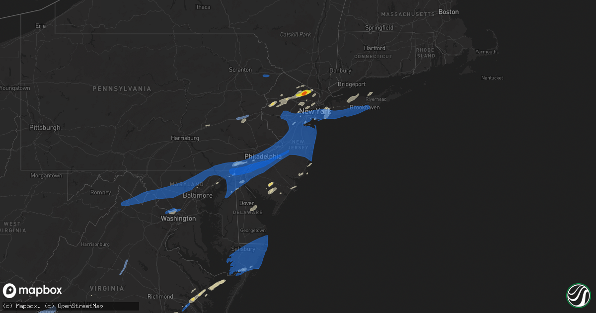
Hail Map in New Jersey on July 22, 2019
Get this storm
July 22 map
$229
one time, instant access
Download today. No call, no setup
Keep the $229
Bought the map and want the full workflow? Apply the entire $229 to a subscription within 7 days. None of it is wasted.
Every map, not just this one
This buys you this map. Subscription and you get every map we run, in the markets you choose from a few cities to whole states to nationwide. Plus real-time alerts the moment a storm fires.
Contact data
Name, contact info, occupancy, even credit band for addresses in the footprint. You go from where it hit to who to call.
Become the source they trust
Unlimited branding weather history reports on demand. You already have the documented answer ready for the property owner, and you are the one who showed up with it.
Property data and RoofTrace estimates
Pull up any address you have got, its value and the exact code rules for that jurisdiction, straight from One Click Code. Then RoofTrace estimates the squares, pitch, and roof value, priced the way you price.
Storm reports in New Jersey
New Jersey
| Date | Description |
|---|---|
| 07/22/20196:48 PM CDT | Site tktn4. |
| 07/22/20196:33 PM CDT | Large tree down in absecon. Time estimated from radar. |
| 07/22/20195:45 PM CDT | Several downed trees and power lines in the area. Time estimated from radar. |
| 07/22/20195:35 PM CDT | Trees and wires down. Time estimated from radar. |
| 07/22/20195:35 PM CDT | Several large trees down. Time estimated from radar. |
| 07/22/20195:34 PM CDT | Numerous trees and power lines down. Time estimated from radar. |
| 07/22/20195:31 PM CDT | Downed power poles and wires on state highway 35 near morgan drawbridge. Time estimated from radar. |
| 07/22/20195:30 PM CDT | Trees and wires down. Time estimated from radar. |
| 07/22/20195:30 PM CDT | Downed tree on nj-35 both directions south of sycamore ave. All lanes closed. Time estimated from radar. |
| 07/22/20195:30 PM CDT | Corrects previous flash flood report from sayreville. Trees down. Time estimated from radar. |
| 07/22/20195:29 PM CDT | 58 mph at lakehurst nas. |
| 07/22/20195:28 PM CDT | Downed tree on nj-33 both directions east of nj-18. All lanes closed. Time estimated from radar. |
| 07/22/20195:27 PM CDT | Trees and wires down on prospect avenue. Time estimated from radar. |
| 07/22/20195:26 PM CDT | Downed tree on nj 36 northbound ramp to garden state parkway. Ramp closed. Time estimated from radar. |
| 07/22/20195:25 PM CDT | Trees and wires down including on us-1. Time estimated from radar. |
| 07/22/20195:25 PM CDT | Several downed trees on garden state parkway both directions from north of exit 105 to north of exit 116. Time estimated from radar. |
| 07/22/20195:25 PM CDT | Downed wires on us 1 southbound at old post rd. All lanes closed and detoured. Time estimated from radar. |
| 07/22/20195:25 PM CDT | Downed tree on garden state parkway northbound entering at exit 98. On-ramp blocked. Time estimated from radar. |
| 07/22/20195:25 PM CDT | Downed tree on garden state parkway express northbound south of exit 109. All lanes blocked. Time estimated from radar. |
| 07/22/20195:25 PM CDT | Downed tree on nj-79 both directions south of wilson ave all lanes closed. Time estimated from radar. |
| 07/22/20195:25 PM CDT | Route 9 south closed due to trees and wires down. Time estimated from radar. |
| 07/22/20195:25 PM CDT | Downed tree on nj-166 both directions at dayton ave. All lanes closed. Time estimated from radar. |
| 07/22/20195:24 PM CDT | Extensive damage in wall twp. Roads closed from storm damage include new bedford road between 18th ave and allaire road... Baileys corner road between 18th ave and alla |
| 07/22/20195:22 PM CDT | Downed tree on garden state parkway near the state highway 33 interchange. Time estimated from radar. |
| 07/22/20195:20 PM CDT | Several trees snapped or uprooted with estimated 60-70mph winds. |
| 07/22/20195:20 PM CDT | Downed wires on us 1 northbound at sandhill rd. Time estimated from radar. |
| 07/22/20195:20 PM CDT | Multiple reports of trees down in lakehurst. Time estimated from radar. |
| 07/22/20195:20 PM CDT | Photo of a tree uprooted in freehold. |
| 07/22/20195:19 PM CDT | Several large trees blown down. Time estimated from radar. |
| 07/22/20195:18 PM CDT | Several reports of downed trees and power lines between milltown and new brunswick. Time estimated from radar. |
| 07/22/20195:17 PM CDT | Downed wires on us 9 southbound at schibanoff ln. All lanes closed and detoured. Time estimated from radar. |
| 07/22/20195:16 PM CDT | Mping report of trees uprooted or snapped. Time estimated from radar. |
| 07/22/20195:16 PM CDT | Widespread tree damage and power outages in and near howell. Time estimated from radar. |
| 07/22/20195:15 PM CDT | Trees and wires down on millstone river rd. |
| 07/22/20195:15 PM CDT | Several trees and power lines down in the area. |
| 07/22/20195:15 PM CDT | Mping report of trees uprooted or snapped. Time estimated from radar. |
| 07/22/20195:14 PM CDT | Trees uprooted throughout town. Several homes had gutter and siding damage. Patio furniture lifted and blown across the yard. Time estimated from radar. |
| 07/22/20195:12 PM CDT | Trees and wires down. Time estimated from radar. |
| 07/22/20195:11 PM CDT | Social media photos of trees blown down or uprooted. Time estimated from radar. |
| 07/22/20195:10 PM CDT | Tree down blocking village rd east. Time estimated from radar. |
| 07/22/20195:10 PM CDT | Downed tree on i-195 eastbound approaching exit 6. |
| 07/22/20195:09 PM CDT | Extensive damage in millstone twp. Numerous trees and power lines down with widespread power outages. Several roads closed. Time estimated from radar. |
| 07/22/20195:05 PM CDT | Trees and wires down on s branch rd. Time estimated from radar. |
| 07/22/20195:05 PM CDT | Downed power lines in tewksbury twp. Time estimated from radar. |
| 07/22/20195:05 PM CDT | Trees down and power out in fort dix. Time estimated from radar. |
| 07/22/20195:02 PM CDT | Multiple small to medium size trees down with one house on post rd damaged by a fallen tree. Time estimated from radar. |
| 07/22/20195:01 PM CDT | Downed tree on interstate 295 southbound ramp to exit 57. Ramp closed. Time estimated from radar. |
| 07/22/20195:00 PM CDT | Trees and wires down. Time estimated from radar. |
| 07/22/20194:57 PM CDT | A local report indicates 76 MPH wind near 2 E FORT DIX |
| 07/22/20194:55 PM CDT | Multiple trees snapped. |
| 07/22/20194:51 PM CDT | Downed tree and wires on mitchell road. Time estimated from radar. |
| 07/22/20194:50 PM CDT | Tree down onto a house on birch dr with an occupant trapped. Time estimated from radar. |
| 07/22/20194:50 PM CDT | 22 inch diameter pine tree snapped. Time estimated from radar. |
| 07/22/20194:50 PM CDT | Tree down blocking a roadway. Time estimated from radar. |
| 07/22/20194:50 PM CDT | Several poles and wires down on moorestown mt laurel rd between church rd and elbo ln. Time estimated from radar. |
| 07/22/20194:48 PM CDT | Large tree uprooted. |
| 07/22/20194:47 PM CDT | Atlantic city rail service suspended in both directions between lindenwold and cherry hill due to a downed tree across the tracks near lindenwold. Time estimated from r |
| 07/22/20194:46 PM CDT | Social media video of roof and building damage with debris spreading across u.s. Highway 130. Time estimated from radar. |
| 07/22/20194:45 PM CDT | Numerous tree limbs down. |
| 07/22/20194:45 PM CDT | Several large trees down... Broken... Or leaned over with power out. Time estimated from radar. |
| 07/22/20194:45 PM CDT | Several trees snapped between union mill rd and hartford rd. Time estimated from radar. |
| 07/22/20194:45 PM CDT | Several downed trees and power lines... Including on bridgeboro road between oneda avenue and creek road. Time estimated from radar. |
| 07/22/20194:45 PM CDT | Tree snapped onto power lines on hartford rd near marne hwy. Time estimated from radar. |
| 07/22/20194:44 PM CDT | Large tree snapped onto power pole lines on stacy haines road. Asos station kvay was no longer available at this time. |
| 07/22/20194:44 PM CDT | Several photos of trees down. Time estimated from radar. |
| 07/22/20194:44 PM CDT | Several downed trees on route 57. Time estimated from radar. |
| 07/22/20194:44 PM CDT | Downed tree on i-295 northbound ramp from exit 10. |
| 07/22/20194:43 PM CDT | Mping report of 3 inch tree limbs or power poles broken. |
| 07/22/20194:42 PM CDT | Burlington nos site |
| 07/22/20194:42 PM CDT | Numerous trees down in and around mount laurel including on ark rd and union mill rd. |
| 07/22/20194:42 PM CDT | Downed wires on us-30 eastbound east of new jersey turnpike. All lanes closed and detoured. Time estimated from radar. |
| 07/22/20194:41 PM CDT | Downed tree on nj-38 eastbound at mt laurel rd. All lanes closed. Time estimated from radar. |
| 07/22/20194:41 PM CDT | Photo of a tree down near old centeron pike. Time estimated from radar. |
| 07/22/20194:41 PM CDT | Several downed tree limbs and wires blocking kings highway. Time estimated from radar. |
| 07/22/20194:40 PM CDT | Several trees... Large branches... And power lines down across the township. Some residential property damage also observed. Time estimated from radar. |
| 07/22/20194:40 PM CDT | Nj weathernet site nj71. |
| 07/22/20194:40 PM CDT | Photo of a large tree uprooted... Which also caused a large area of a residential yard to be torn out of the ground. Time estimated from radar. |
| 07/22/20194:38 PM CDT | Several trees blown down or uprooted in the area. Time estimated from radar. |
| 07/22/20194:38 PM CDT | Power line snapped and another blown to the ground with no influence from trees or debris. Time estimated from radar. |
| 07/22/20194:37 PM CDT | Mping report of trees uprooted or snapped. Time estimated from radar. |
| 07/22/20194:37 PM CDT | Several large tree branches and power lines down. One tree snapped. Church street closed at this location. Time estimated from radar. |
| 07/22/20194:37 PM CDT | Photo of a tree snapped with power lines down on station ave in haddon heights. Time estimated from radar. |
| 07/22/20194:36 PM CDT | Downed tree across prospect street near main street. Time estimated from radar. |
| 07/22/20194:35 PM CDT | A local report indicates 70 MPH wind near CAMDEN |
| 07/22/20194:35 PM CDT | A local report indicates 60 MPH wind near MAPLE SHADE |
| 07/22/20194:34 PM CDT | Downed tree and wires on barrymore street. Time estimated from radar. |
| 07/22/20194:33 PM CDT | Several large trees fell across the roadway in audubon / westmont just off cuthbert blvd. Time estimated from radar. |
| 07/22/20194:32 PM CDT | Widespread tree... Power line... And other damage throughout collingswood. Estimated gusts 70-80mph. Time estimated from radar. |
| 07/22/20194:32 PM CDT | Downed tree on third street in phillipsburg. Time estimated from radar. |
| 07/22/20194:32 PM CDT | Downed street light at intersection of memorial parkway and bates street. Time estimated from radar. |
| 07/22/20194:30 PM CDT | State highway 611 closed between browns drive and cedarville road from downed trees. Time estimated from radar. |
| 07/22/20194:28 PM CDT | Downed tree and wires on nj-10 both directions near of canfield ave. Time estimated from radar. |
| 07/22/20194:28 PM CDT | Downed trees and power lines in the area. Time estimated from radar. |
| 07/22/20194:02 PM CDT | Tree down on wires with fire at the intersection of stephensburg rd and nj-57. Time estimated from radar. |
| 07/22/20194:02 PM CDT | Downed tree on i-80 westbound east of exit 30. Time estimated from radar. |
| 07/22/20193:41 PM CDT | Several reports of trees and wires down in and around hackettstown... Including on ridge lane and lindsey drive. Time estimated from radar. |
| 07/22/20193:40 PM CDT | Downed tree across cedarville road. Time estimated from radar. |
| 07/22/20193:25 PM CDT | Tree down on wires on heller hill rd. Time estimated from radar. |
| 07/22/20193:14 PM CDT | Ping pong size hail reported. |
| 07/22/20193:09 PM CDT | Golf ball size hail reported. |
| 07/22/20193:02 PM CDT | Quarter size hail reported. |
| 07/22/20193:01 PM CDT | Ping pong size hail reported |
| 07/22/20192:59 PM CDT | Ping pong size hail reported. |
| 07/22/20192:55 PM CDT | Social media video of hail which appeared up to quarter size. Time estimated from radar. |
| 07/22/20192:50 PM CDT | Minor damage to deck and plants shredded. |
| 07/22/20192:30 PM CDT | Social media report of trees down on green pond rd. |
| 07/22/20192:28 PM CDT | Trees and wires down on penn ave. Time estimated from radar. |
| 07/22/20192:14 PM CDT | Multiple reports of wires down near roxbury. Time estimated from radar. |
| 07/22/20192:14 PM CDT | Trees and wires down on oliver rd. Time estimated from radar. |
| 07/22/20192:12 PM CDT | Downed trees and power lines throughout town. Time estimated from radar. |
| 07/22/20192:09 PM CDT | Downed tree on brooklyn-stanhope road near flora avenue. Time estimated from radar. |
| 07/22/20192:07 PM CDT | Downed tree on interstate 80 near the u.s. Highway 206 interchange. Time estimated from radar. |
| 07/22/20197:34 AM CDT | At 1234 AM EDT, a severe thunderstorm was located over Six Flags Theme Park, or 17 miles southeast of Trenton, moving east at 30 mph. HAZARD...60 mph wind gusts and quarter size hail. SOURCE...Radar indicated. IMPACT...Minor damage to vehicles is possible. Wind damage to roofs, siding, trees, and power lines is possible. Locations impacted include... Toms River, Long Branch, Asbury Park, Lakewood, Jackson, Howell, Tinton Falls, Beachwood, Manasquan, Point Pleasant Beach, Seaside Heights, Lakehurst, Farmingdale, Mantoloking, Allenwood, Six Flags Theme Park, Cassville, Adelphia, Vista Center and Elberon. |
| 07/22/20191:54 AM CDT | At 654 PM EDT, severe thunderstorms were located along a line extending from Highlands to near Barnegat to 10 miles south of Fortesque, moving east at 30 mph. HAZARD...60 mph wind gusts. SOURCE...Radar indicated. IMPACT...Damage to roofs, siding, trees, and power lines is possible. Locations impacted include... Toms River, Vineland, Atlantic City, Millville, Ocean City, Cumberland, Lakewood, Middletown, Howell, Barnegat, Pleasantville, Tinton Falls, Holmdel, Red Bank, Beachwood, Somers Point, Keansburg, Brigantine, Northfield and Absecon. |
| 07/22/20191:35 AM CDT | At 634 PM EDT, severe thunderstorms were located along a line extending from near Edison to near Highlands to 21 miles east of Mantoloking, moving east at 65 mph. HAZARD...60 mph wind gusts. SOURCE...Radar indicated. IMPACT...Expect damage to trees and power lines. Severe thunderstorms will be near... Jersey City and Bayonne around 650 PM EDT. Flatbush and Crown Heights around 655 PM EDT. Flushing and Rockaway Beach around 700 PM EDT. Jamaica and Valley Stream around 705 PM EDT. Freeport and Garden City around 710 PM EDT. Levittown and Plainview around 715 PM EDT. |
| 07/22/20191:27 AM CDT | At 626 PM EDT, severe thunderstorms were located along a line extending from Morris Plains to Gardenville, moving east at 30 mph. HAZARD...70 mph wind gusts and penny size hail. SOURCE...Law enforcement. Several reports of trees and wires down have been received from Somerset, Warren, Hunterdon, and Mercer Counties in association with these storms. IMPACT...Expect considerable tree damage. Damage is likely to mobile homes, roofs, and outbuildings. Locations impacted include... New Brunswick, Perth Amboy, Morristown, Somerville, Somerset, Edison, Old Bridge, East Brunswick, Bridgewater, South Brunswick, Sayreville, North Brunswick, Carteret, Dover, Madison, Middlesex, Florham Park, East Hanover, Bound Brook and Manville. |
| 07/22/20191:09 AM CDT | At 607 PM EDT, severe thunderstorms were located along a line extending from Mizpah to near Dorothy to near Bivalve, moving northeast at 40 mph. HAZARD...60 mph wind gusts. SOURCE...Radar indicated. IMPACT...Damage to roofs, siding, trees, and power lines is possible. Locations impacted include... Vineland, Atlantic City, Millville, Ocean City, Cumberland, Pleasantville, Somers Point, Ventnor City, Brigantine, Northfield, Absecon, Margate City, Egg Harbor City, Laurel Lake, Tuckerton, Weymouth, Woodbine, Sea Isle City, Estell Manor and Port Republic. |
| 07/22/201912:24 AM CDT | Hads sensor. |
| 07/22/201912:01 AM CDT | At 500 PM EDT, a severe thunderstorm was located over Mount Arlington, or 10 miles southeast of Newton, moving east at 40 mph. HAZARD...60 mph wind gusts and quarter size hail. SOURCE...Radar indicated. IMPACT...Minor damage to vehicles is possible. Wind damage to roofs, siding, trees, and power lines is possible. Locations impacted include... Dover, Hopatcong, Lincoln Park, Kinnelon, Hackettstown, Boonton, Butler, Wharton, Rockaway, Morris Plains, Mount Arlington, Mountain Lakes, Stanhope, Riverdale, Netcong, Victory Gardens, Andover, Long Valley, Green Pond and Great Meadows-Vienna. |
| 07/22/201912:01 AM CDT | At 501 PM EDT, a severe thunderstorm was located over Bloomingdale, or over Pompton Lakes, moving northeast at 25 mph. HAZARD...60 mph wind gusts and quarter size hail. SOURCE...Radar indicated. IMPACT...Minor hail damage to vehicles is possible. Expect wind damage to trees and power lines. This severe thunderstorm will be near... Ringwood around 515 PM EDT. Ramsey and Suffern around 525 PM EDT. Monsey around 535 PM EDT. Nanuet and Pearl River around 540 PM EDT. New City and Pomona around 545 PM EDT. Nyack and Upper Nyack around 550 PM EDT. Haverstraw around 555 PM EDT. Ossining around 600 PM EDT. |
| 07/21/201911:55 PM CDT | At 455 PM EDT, severe thunderstorms were located along a line extending from near Claussville to near Laureldale, moving east at 40 mph. HAZARD...60 mph wind gusts and penny size hail. SOURCE...Radar indicated. IMPACT...Damage to roofs, siding, trees, and power lines is possible. Locations impacted include... Allentown, Reading, Easton, Bethlehem, Forks, Emmaus, Wyomissing, Northampton, Quakertown, Wilson, Hellertown, Nazareth, Kutztown, Hamburg, Fleetwood, Laureldale, East Greenville, Bath, Topton and Leesport. |
| 07/21/201910:38 PM CDT | At 338 PM EDT, a severe thunderstorm was located over Kinnelon, or near Pompton Lakes, moving east at 40 mph. HAZARD...60 mph wind gusts and quarter size hail. SOURCE...Radar indicated. IMPACT...Minor hail damage to vehicles is possible. Expect wind damage to trees and power lines. This severe thunderstorm will be near... Pompton Lakes around 345 PM EDT. Wayne around 350 PM EDT. Paterson and Hawthorne around 355 PM EDT. Paramus and Ridgewood around 400 PM EDT. Monsey and Oradell around 405 PM EDT. Bergenfield and Nanuet around 410 PM EDT. Tappan and Norwood around 415 PM EDT. Yonkers and Tarrytown around 420 PM EDT. Ossining and Scarsdale around 425 PM EDT. White Plains and Harrison around 430 PM EDT. |
| 07/21/201910:27 PM CDT | At 327 PM EDT, severe thunderstorms were located along a line extending from Pocono Pines to Echo Lake, moving east at 40 mph. HAZARD...60 mph wind gusts and penny size hail. SOURCE...Radar indicated. IMPACT...Damage to roofs, siding, trees, and power lines is possible. Locations impacted include... Mount Pocono, Tobyhanna, Henryville, Werry Lake, Pocono Pines, Analomink, Skytop, Mountainhome, Canadensis, Alpine Mountain, Scotrun, Blakeslee, Echo Lake, Paradise Valley, Gouldsboro State Park, Arrowhead Lake, Long Pond, Cresco, Marshalls Creek and Hidden Lake. |
| 07/21/201910:12 PM CDT | At 312 PM EDT, a severe thunderstorm was located over Mount Arlington, or 10 miles southeast of Newton, moving east at 25 mph. HAZARD...70 mph wind gusts and quarter size hail. SOURCE...Radar indicated. IMPACT...Minor damage to vehicles is possible. Expect considerable tree damage. Wind damage is also likely to mobile homes, roofs, and outbuildings. Locations impacted include... Dover, Hopatcong, East Hanover, Lincoln Park, Kinnelon, Boonton, Butler, Wharton, Rockaway, Morris Plains, Mount Arlington, Mountain Lakes, Stanhope, Riverdale, Netcong, Victory Gardens, Andover, Lake Mohawk, Green Pond and Succasunna. |
| 07/21/20199:59 PM CDT | At 259 PM EDT, severe thunderstorms were located along a line extending from near Bloomingburg to near Florida to near Vernon Valley, moving east at 25 mph. HAZARD...60 mph wind gusts. SOURCE...Radar indicated. IMPACT...Expect damage to trees and power lines. Severe thunderstorms will be near... Goshen and Florida around 305 PM EDT. Chester around 310 PM EDT. Montgomery around 315 PM EDT. Walden and Warwick around 320 PM EDT. Monroe around 325 PM EDT. Greenwood Lake and Harriman around 330 PM EDT. Ringwood and Gardnertown around 335 PM EDT. Newburgh and West Point around 340 PM EDT. Suffern and Cold Spring around 350 PM EDT. Peekskill around 355 PM EDT. New City and Monsey around 400 PM EDT. |
All States Impacted by Hail Map on July 22, 2019
Cities Impacted by Hail Map on July 22, 2019
- Jamaica, NY
- Beach Haven, NJ
- Manahawkin, NJ
- Garrett, WY
- Lake George, CO
- Cleburne, TX
- Burleson, TX
- San Saba, TX
- Globe, AZ
- Waldwick, NJ
- Allendale, NJ
- Wyckoff, NJ
- Wayne, NJ
- Ramsey, NJ
- Haskell, NJ
- Pompton Plains, NJ
- Oakland, NJ
- Bloomingdale, NJ
- Butler, NJ
- Saddle River, NJ
- Riverdale, NJ
- Lincoln Park, NJ
- Boonton, NJ
- Pompton Lakes, NJ
- Mahwah, NJ
- Towaco, NJ
- Franklin Lakes, NJ
- Merry Hill, NC
- Colerain, NC
- Locust Hill, VA
- Topping, VA
- Saluda, VA
- Gloucester, VA
- Kew Gardens, NY
- Oakland Gardens, NY
- Saint Albans, NY
- Woodmere, NY
- Far Rockaway, NY
- Hewlett, NY
- Rosedale, NY
- Malverne, NY
- Great Neck, NY
- New Hyde Park, NY
- Fresh Meadows, NY
- Glen Oaks, NY
- Cedarhurst, NY
- Lynbrook, NY
- Forest Hills, NY
- Flushing, NY
- Floral Park, NY
- Garden City, NY
- Little Neck, NY
- Lawrence, NY
- Elmont, NY
- South Richmond Hill, NY
- Springfield Gardens, NY
- Queens Village, NY
- South Ozone Park, NY
- Bellerose, NY
- Inwood, NY
- Cambria Heights, NY
- Richmond Hill, NY
- Bayside, NY
- Hollis, NY
- Valley Stream, NY
- Arverne, NY
- Wetmore, CO
- Westcliffe, CO
- Thermopolis, WY
- Disputanta, VA
- Vail, AZ
- Vineland, NJ
- Joshua, TX
- Alvarado, TX
- Keene, TX
- Purdys, NY
- Suffolk, VA
- Franklin, VA
- Franklin, TX
- Crowheart, WY
- White Stone, VA
- Toano, VA
- Williamsburg, VA
- Shacklefords, VA
- Barhamsville, VA
- Weems, VA
- Aberdeen, MD
- Aberdeen Proving Ground, MD
- Pavillion, WY
- Shoshoni, WY
- Miami, AZ
- Wingo, KY
- Water Valley, KY
- Woodcliff Lake, NJ
- Hibernia, NJ
- Randolph, NJ
- Ledgewood, NJ
- Budd Lake, NJ
- Denville, NJ
- Hopatcong, NJ
- Mount Arlington, NJ
- Stanhope, NJ
- Chester, NJ
- West Milford, NJ
- Lake Hopatcong, NJ
- Long Valley, NJ
- Flanders, NJ
- Monsey, NY
- Montvale, NJ
- Montville, NJ
- Dover, NJ
- Rockaway, NJ
- Wanaque, NJ
- Spring Valley, NY
- Mine Hill, NJ
- Midland Park, NJ
- Kenvil, NJ
- Netcong, NJ
- Landing, NJ
- Hackettstown, NJ
- Port Murray, NJ
- Succasunna, NJ
- Wharton, NJ
- Prince George, VA
- Spring Grove, VA
- Emory, TX
- Oxford, NJ
- Great Meadows, NJ
- Belvidere, NJ
- Charles City, VA
- Riner, VA
- Christiansburg, VA
- Westfield, NJ
- Clark, NJ
- Scotch Plains, NJ
- Divide, CO
- Broaddus, TX
- Tucson, AZ
- Conway, NC
- Twentynine Palms, CA
- Joshua Tree, CA
- Darby, MT
- Corsicana, TX
- Barry, TX
- Peridot, AZ
- Sonoita, AZ
- Trexlertown, PA
- Allentown, PA
- Alburtis, PA
- Mertztown, PA
- Breinigsville, PA
- Macungie, PA
- Keenesburg, CO
- Hudson, CO
- Normangee, TX
- McLeod, MT
- Saint David, AZ
- Lolo, MT
- Florence, MT
- Casper, WY
- Myerstown, PA
- Fredericksburg, PA
- Bethel, PA
- Hamilton, TX
- Jonesboro, TX
- Egg Harbor Township, NJ
- Absecon, NJ
- Pleasantville, NJ
- Sierra Vista, AZ
- Hereford, AZ
- Kilmarnock, VA
- Lutherville Timonium, MD
- Towson, MD
- Payson, AZ
- Lander, WY
- Kearny, NJ
- Newark, NJ
- North Arlington, NJ
- Belleville, NJ
- Newark, DE
- Elkton, MD
- Riverton, WY
- Watkins, CO
- Commerce City, CO
- Aurora, CO
- Young, AZ
- New Church, VA
- Pocomoke City, MD
- Old Westbury, NY
- Howard, CO
- Salida, CO
- Mountainside, NJ
- New Providence, NJ
- Summit, NJ
- Springfield, NJ
- Townsend, DE
- Parker, CO
- Middletown, DE
- Port Penn, DE
- Loving, NM
- Gladstone, VA
- Carlsbad, NM
- Landenberg, PA
- Avondale, PA
- Millville, NJ
- Petersburg, VA
- Rayville, LA
- Mangham, LA
- Williamston, NC
- Staten Island, NY
- Chadds Ford, PA
- Kennett Square, PA
- Toughkenamon, PA
- Washington, NJ
- Somerset, NJ
- New Brunswick, NJ
- Piscataway, NJ
- Galena, MD
- Edenton, NC
- Sells, AZ
- South Bay, FL
- Belle Glade, FL
- Rockville, MD
- Kensington, MD
- Garrett Park, MD
- Chevy Chase, MD
- Silver Spring, MD
- Potomac, MD
- Glen Echo, MD
- Bethesda, MD
- Cabin John, MD
- Moonachie, NJ
- Palisades Park, NJ
- Carlstadt, NJ
- East Rutherford, NJ
- Secaucus, NJ
- Little Ferry, NJ
- Ridgefield, NJ
- Ridgefield Park, NJ
- Brooklyn, NY
- Ringwood, NJ
- McNeal, AZ
- Murfreesboro, NC
- Pendleton, NC
- Woodbine, NJ
- Stockton, MD
- Girdletree, MD
- Bisbee, AZ
- Cody, WY
- Bloomfield, NJ
- East Orange, NJ
- Windsor, NC
- Township Of Washington, NJ
- Oradell, NJ
- Harrington Park, NJ
- Paramus, NJ
- Emerson, NJ
- Westwood, NJ
- Lone Tree, CO
- Denver, CO
- Buffalo, TX
- Verona, NJ
- Caldwell, NJ
- Roseland, NJ
- Fairfield, NJ
- Essex Fells, NJ
- Livingston, NJ
- West Orange, NJ
- East Hanover, NJ
- Cedar Grove, NJ
- Delhi, LA
- Winnsboro, LA
- Milmay, NJ
- Port Elizabeth, NJ
- Milford, DE
- Frederica, DE
- Marion Station, MD
- Oak Hall, VA
- Fulton, KY
- Marlin, TX
- East Northport, NY
- Northport, NY
- Saint James, NY
- Kings Park, NY
- East Setauket, NY
- Port Jefferson, NY
- Smithtown, NY
- Commack, NY
- Stony Brook, NY
- Hockessin, DE
- Garnet Valley, PA
- Wilmington, DE
- West Grove, PA
- Glen Mills, PA
- Bennett, CO
- Goldonna, LA
- Greycliff, MT
- Hardyville, VA
- Hartfield, VA
- Wake, VA
- Wading River, NY
- Check, VA
- Pilot, VA
- Floyd, VA
- Gates, NC
- Warner Springs, CA
- Little Falls, NJ
- Paterson, NJ
- Woodlyn, PA
- Swarthmore, PA
- Brookhaven, PA
- Chester, PA
- Wallingford, PA
- Santa Anna, TX
- Tangier, VA
- Andover, NJ
- Lanexa, VA
- Como, NC
- Newsoms, VA
- Jasper, TX
- Zavalla, TX
- Columbia, LA
- Grayson, LA
- Tuckerton, NJ
- West Creek, NJ
- Meadows Of Dan, VA
- Big Sky, MT
- Abingdon, MD
- Mount Vernon, TX
- Pima, AZ
- Amado, AZ
- Green Valley, AZ
- Mascot, VA
- Urbanna, VA
- Church View, VA
- Moneta, VA
- Clinton, KY
- Southside, TN
- Charlotte, TN
- Cumberland Furnace, TN
- Long Branch, NJ
- Folcroft, PA
- Kennedyville, MD
- Somerville, NJ
- Columbus, NJ
- Middle Village, NY
- Mastic Beach, NY
- Brightwaters, NY
- Deal, NJ
- Cranbury, NJ
- Merrick, NY
- Pennsauken, NJ
- Robbinsville, NJ
- Dayton, NJ
- Woodbridge, NJ
- Freehold, NJ
- Sayville, NY
- Drexel Hill, PA
- Basking Ridge, NJ
- Bradley Beach, NJ
- Perryville, MD
- West Berlin, NJ
- Monroeville, NJ
- Buckeystown, MD
- Saint Georges, DE
- Jefferson, MD
- Carteret, NJ
- Millington, MD
- Plainfield, NJ
- Mickleton, NJ
- Middlesex, NJ
- Ranson, WV
- Fanwood, NJ
- Allenwood, NJ
- Millstone Township, NJ
- Spotswood, NJ
- Springfield, PA
- Folsom, PA
- Mount Airy, MD
- Hainesport, NJ
- Pedricktown, NJ
- Marlton, NJ
- Sicklerville, NJ
- Warwick, MD
- Round Hill, VA
- Colonia, NJ
- Lincroft, NJ
- Rockville Centre, NY
- Bayport, NY
- Mantua, NJ
- Marriottsville, MD
- Bellmawr, NJ
- East Meadow, NY
- Red Bank, NJ
- Wrightstown, NJ
- Mullica Hill, NJ
- Oaklyn, NJ
- Holbrook, NY
- Massapequa, NY
- Trenton, NJ
- Marlboro, NJ
- Plainsboro, NJ
- Ozone Park, NY
- Brentwood, NY
- Elk Mills, MD
- Roselle Park, NJ
- Keyport, NJ
- Berryville, VA
- Rahway, NJ
- Lindenhurst, NY
- Manchester Township, NJ
- Aston, PA
- Mount Royal, NJ
- Oakdale, NY
- Oceanport, NJ
- Hillsborough, NJ
- Union, NJ
- Odessa, DE
- Sparks Glencoe, MD
- Beachwood, NJ
- Gaithersburg, MD
- Palmyra, NJ
- Essington, PA
- Matawan, NJ
- Great River, NY
- Roselle, NJ
- Cochranville, PA
- Lakehurst, NJ
- Farmingdale, NY
- Farmingdale, NJ
- Oxford, PA
- Fair Haven, NJ
- Fallston, MD
- Bala Cynwyd, PA
- Avon By The Sea, NJ
- Blackwood, NJ
- Germantown, MD
- Haddonfield, NJ
- Long Island City, NY
- Franklin Park, NJ
- Cecilton, MD
- Islip, NY
- Chesapeake City, MD
- Far Hills, NJ
- Riverside, NJ
- Haddon Heights, NJ
- Phoenix, MD
- Gibbsboro, NJ
- Brunswick, MD
- Breezy Point, NY
- Audubon, NJ
- Burlington, NJ
- Magnolia, NJ
- Old Bridge, NJ
- New Castle, DE
- Fords, NJ
- Atlantic Highlands, NJ
- Levittown, PA
- Iselin, NJ
- Bethpage, NY
- Ijamsville, MD
- Stratford, NJ
- Windsor, NJ
- Summit Point, WV
- Mastic, NY
- Pikesville, MD
- Lansdowne, PA
- Sayreville, NJ
- Parkton, MD
- Thorofare, NJ
- Salem, NJ
- Lovettsville, VA
- Belford, NJ
- Oceanside, NY
- Rego Park, NY
- Jarrettsville, MD
- Woodbury Heights, NJ
- Glendora, NJ
- Ocean Beach, NY
- Darby, PA
- North Brunswick, NJ
- West Islip, NY
- Neptune, NJ
- White Hall, MD
- Ronkonkoma, NY
- Manville, NJ
- Shrewsbury, NJ
- Seaside Heights, NJ
- Point Lookout, NY
- Freeport, NY
- Bristol, PA
- Upper Darby, PA
- Knoxville, MD
- Morrisville, PA
- Chesterfield, NJ
- Prospect Park, PA
- Keasbey, NJ
- Marcus Hook, PA
- Quarryville, PA
- Berkeley Heights, NJ
- Owings Mills, MD
- Clear Brook, VA
- Beverly, NJ
- Ridley Park, PA
- Bordentown, NJ
- Purcellville, VA
- Harpers Ferry, WV
- Cream Ridge, NJ
- Pennsville, NJ
- Little Silver, NJ
- South Bound Brook, NJ
- Babylon, NY
- Highland Park, NJ
- Lincoln University, PA
- National Park, NJ
- Fairless Hills, PA
- Cherry Hill, NJ
- New York, NY
- Bel Air, MD
- Highlands, NJ
- Baldwin, MD
- Pitman, NJ
- Clementon, NJ
- Sewell, NJ
- Waterford, VA
- Cranford, NJ
- Chestertown, MD
- Perth Amboy, NJ
- Califon, NJ
- Brielle, NJ
- Whiteford, MD
- Helmetta, NJ
- Monrovia, MD
- Joint Base Mdl, NJ
- Conowingo, MD
- North East, MD
- Riverton, NJ
- Roebling, NJ
- Center Moriches, NY
- Millington, NJ
- Gladstone, NJ
- New Egypt, NJ
- Camden, NJ
- Cheltenham, PA
- Jersey City, NJ
- South Plainfield, NJ
- Somerdale, NJ
- Island Park, NY
- Asbury Park, NJ
- Martinsville, NJ
- Bensalem, PA
- Glenolden, PA
- Reisterstown, MD
- Sewaren, NJ
- Brick, NJ
- Bridgewater, NJ
- Thornton, PA
- Mantoloking, NJ
- Berlin, NJ
- Levittown, NY
- Voorhees, NJ
- Williamstown, NJ
- Pine Beach, NJ
- Middletown, NJ
- Hempstead, NY
- Hazlet, NJ
- Upperco, MD
- Howard Beach, NY
- Wenonah, NJ
- Parlin, NJ
- Brookhaven, NY
- Deer Park, NY
- Mount Ephraim, NJ
- Paulsboro, NJ
- Pylesville, MD
- Bound Brook, NJ
- Woodstock, MD
- Barnesville, MD
- Penns Grove, NJ
- Street, MD
- Pemberton, NJ
- Cliffwood, NJ
- New Market, MD
- Clarksboro, NJ
- Sea Girt, NJ
- Amityville, NY
- Blue Point, NY
- Gibbstown, NJ
- Glyndon, MD
- West Long Branch, NJ
- Port Reading, NJ
- Browns Mills, NJ
- East Rockaway, NY
- Point Of Rocks, MD
- Crum Lynne, PA
- Bellmore, NY
- South River, NJ
- Clifton Heights, PA
- Elizabeth, NJ
- Allentown, NJ
- Bay Shore, NY
- Massey, MD
- Leonardo, NJ
- Broomall, PA
- New Windsor, MD
- Peapack, NJ
- Adamstown, MD
- Medford, NJ
- Glassboro, NJ
- Claymont, DE
- Media, PA
- Woodstown, NJ
- Bellport, NY
- Watchung, NJ
- Ocean Grove, NJ
- Hillside, NJ
- Grenloch, NJ
- Seaford, NY
- Kendall Park, NJ
- Runnemede, NJ
- Metuchen, NJ
- Finksburg, MD
- Bayonne, NJ
- Woodbury, NJ
- Woodside, NY
- Clarksburg, MD
- Charlestown, MD
- Linden, NJ
- West Babylon, NY
- Central Islip, NY
- Woodhaven, NY
- Cockeysville, MD
- Edison, NJ
- Merchantville, NJ
- Brookeville, MD
- Swedesboro, NJ
- Maspeth, NY
- Charles Town, WV
- Bear, DE
- Holtsville, NY
- Elmhurst, NY
- Leesburg, VA
- Massapequa Park, NY
- Peach Bottom, PA
- Mount Laurel, NJ
- Englishtown, NJ
- Bohemia, NY
- Seaside Park, NJ
- Dunellen, NJ
- Roosevelt, NJ
- Georgetown, MD
- Westville, NJ
- Morganville, NJ
- Whitehouse Station, NJ
- Ocean Gate, NJ
- Kenilworth, NJ
- Princeton, NJ
- Millville, WV
- Earleville, MD
- Atlantic Beach, NY
- Belmar, NJ
- Boyds, MD
- Lawrence Township, NJ
- East Islip, NY
- Franklin Square, NY
- Dickerson, MD
- Monkton, MD
- Warren, NJ
- Lakewood, NJ
- Glenwood, MD
- West Sayville, NY
- Baldwin, NY
- Randallstown, MD
- Howell, NJ
- Mount Holly, NJ
- Philadelphia, PA
- Hunt Valley, MD
- Jackson, NJ
- Copiague, NY
- Norwood, PA
- Point Pleasant Beach, NJ
- Monmouth Beach, NJ
- Cooksville, MD
- Island Heights, NJ
- Colts Neck, NJ
- Florence, NJ
- Bedminster, NJ
- Morton, PA
- Vincentown, NJ
- Lawnside, NJ
- Croydon, PA
- Moriches, NY
- Princeton Junction, NJ
- Drumore, PA
- Manasquan, NJ
- Merion Station, PA
- Holmes, PA
- Rising Sun, MD
- Damascus, MD
- Woodbine, MD
- Monroe Township, NJ
- Stephenson, VA
- Bayville, NJ
- Kirkwood, PA
- Collingswood, NJ
- Stirling, NJ
- Port Deposit, MD
- Eatontown, NJ
- Patchogue, NY
- Bernardsville, NJ
- South Amboy, NJ
- Stevenson, MD
- Rumson, NJ
- Ridgewood, NY
- Montchanin, DE
- Rockaway Park, NY
- Port Monmouth, NJ
- Colora, MD
- Raritan, NJ
- Islip Terrace, NY
- Rockland, DE
- Lumberton, NJ
- East Brunswick, NJ
- Maple Shade, NJ
- West Chester, PA
- Keansburg, NJ
- Monmouth Junction, NJ
- Delaware City, DE
- Oakhurst, NJ
- Langhorne, PA
- Forest Hill, MD
- Willingboro, NJ
- Barrington, NJ
- Garwood, NJ
- Rancocas, NJ
- Wantagh, NY
- Gloucester City, NJ
- Bridgeport, NJ
- North Babylon, NY
- Havertown, PA
- West Friendship, MD
- Westminster, MD
- Frederick, MD
- Boyce, VA
- Avenel, NJ
- Elizabethport, NJ
- Toms River, NJ
- Uniondale, NY
- Sykesville, MD
- Sharon Hill, PA
- Jobstown, NJ
- Winchester, VA
- Cookstown, NJ
- Yorklyn, DE
- Delta, PA
- Tuscarora, MD
- Roosevelt, NY
- Allenhurst, NJ
- Hightstown, NJ
- Milltown, NJ
- Shirley, NY
- Wynnewood, PA
- Moorestown, NJ
- West Hempstead, NY
- Long Beach, NY
- Fort Monmouth, NJ
- Nottingham, PA
- Lavallette, NJ
- Darlington, MD
- Holmdel, NJ
- Chester Heights, PA
- Spring Lake, NJ
- Stephens City, VA
- Vienna, VA
- McLean, VA
- Great Falls, VA
- Greentown, PA
- Hawley, PA
- Dingmans Ferry, PA
- Milford, PA
- Kutztown, PA
- Whitehall, PA
- Orefield, PA
- New Tripoli, PA
- Fogelsville, PA
- Blue Ridge, VA
- Goodview, VA
- Shawsville, VA
- Elliston, VA
- Callaway, VA
- Roanoke, VA
- Bent Mountain, VA
- Copper Hill, VA
- Hardy, VA
- Salem, VA
- Vinton, VA
- Boones Mill, VA
- Gordonsville, VA
- Troy, VA
- Palmyra, VA
- Skipwith, VA
- Chase City, VA
- Portsmouth, VA
- Chesapeake, VA
- Carrsville, VA
- Windsor, VA
- Blackstone, VA
- Kenbridge, VA
- Crewe, VA
- Courtland, VA
- Waverly, VA
- Hallwood, VA
- Chincoteague Island, VA
- Temperanceville, VA
- Princess Anne, MD
- Dagsboro, DE
- Millville, DE
- Eden, MD
- Millsboro, DE
- Quantico, MD
- Willards, MD
- Crisfield, MD
- Bethany Beach, DE
- Delmar, DE
- Whaleyville, MD
- Sanford, VA
- Fenwick Island, DE
- Tyaskin, MD
- Greenbackville, VA
- Ocean City, MD
- Berlin, MD
- Westover, MD
- Newark, MD
- Ocean View, DE
- Deal Island, MD
- Salisbury, MD
- Selbyville, DE
- Parsonsburg, MD
- Delmar, MD
- Frankford, DE
- Bishopville, MD
- Fruitland, MD
- Snow Hill, MD
- Pittsville, MD
- Showell, MD
- Haledon, NJ
- Deer Trail, CO
- Strasburg, CO
- Agate, CO
- Kiowa, CO
- Elizabeth, CO
- Ramah, CO
- Littleton, CO


