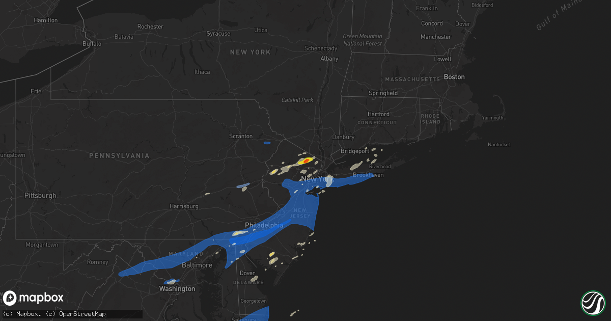
Hail Map on July 22, 2019
Get this storm
July 22 map
$229
one time, instant access
Download today. No call, no setup
Keep the $229
Bought the map and want the full workflow? Apply the entire $229 to a subscription within 7 days. None of it is wasted.
Every map, not just this one
This buys you this map. Subscription and you get every map we run, in the markets you choose from a few cities to whole states to nationwide. Plus real-time alerts the moment a storm fires.
Contact data
Name, contact info, occupancy, even credit band for addresses in the footprint. You go from where it hit to who to call.
Become the source they trust
Unlimited branding weather history reports on demand. You already have the documented answer ready for the property owner, and you are the one who showed up with it.
Property data and RoofTrace estimates
Pull up any address you have got, its value and the exact code rules for that jurisdiction, straight from One Click Code. Then RoofTrace estimates the squares, pitch, and roof value, priced the way you price.
States Impacted by Hail Map on July 22, 2019
Storm reports
Mississippi
| Date | Description |
|---|---|
| 07/22/20194:10 PM CDT | One large tree fell down over a small shed in richmond. |
| 07/22/20191:31 AM CDT | At 631 PM CDT, a severe thunderstorm was located over Okolona, moving east at 35 mph. HAZARD...60 mph wind gusts. SOURCE...Radar indicated. IMPACT...Expect damage to roofs, siding, and trees. Locations impacted include... Amory, Okolona, Shannon, Smithville, New Wren, Nettleton, Hatley, Becker, Bigbee, Leotis and Wren. |
| 07/22/20191:02 AM CDT | At 602 PM CDT, a severe thunderstorm was located near Yazoo City, moving southeast at 10 mph. HAZARD...60 mph wind gusts and penny size hail. SOURCE...Radar indicated. IMPACT...Expect damage to roofs, siding, and trees. This severe thunderstorm will be near... Tinsley around 630 PM CDT. Little Yazoo and Myrleville around 645 PM CDT. |
Texas
| Date | Description |
|---|---|
| 07/22/20195:40 PM CDT | Sheriff department trees down on county road 1605 near the dialville community. |
| 07/22/20195:30 PM CDT | Sheriff department reports trees down near the intersection of fm road 747 and county road 1905 in the pierces chapel community. |
| 07/22/20195:05 PM CDT | Sheriff department reports trees down on county road 3411. |
| 07/22/20195:00 PM CDT | Sheriff department reports large tree blocking county road 3504 near the blackburn crossing dam. |
| 07/22/20195:00 PM CDT | Sheriff department reports trees down on fm road 2137 about a mile north of fm road 855. |
North Carolina
| Date | Description |
|---|---|
| 07/22/20196:57 PM CDT | Corrects previous tstm wnd dmg report from 2 ssw monroeton. Several trees downed on power lines along spearman drive near haw river state park. Time estimated from rada |
| 07/22/20196:40 PM CDT | Power lines were reported down at 9211 us highway 15 north... North of bullock. |
| 07/22/20196:30 PM CDT | Tree downed in colerain near colerain baptist church. |
| 07/22/20196:05 PM CDT | Trees were reported down on power lines along reynolda road near valley road. |
| 07/22/20196:00 PM CDT | Multiple trees and power lines were reported down in the timberlake area. |
| 07/22/20195:40 PM CDT | Trained spotter reported trees down on the roadway in the 300 block of garden valley rd. |
| 07/22/20195:35 PM CDT | Spotter reported tree down in yard. |
| 07/22/20195:33 PM CDT | Corrects previous tstm wnd dmg report from 2 sse capella. Tree blown down at intersection of johnson road and robertson ridge road. Time estimated from radar. |
| 07/22/20195:29 PM CDT | Tree blown down on shady grove road... Near t clarence stone highway. Time estimated from radar. |
| 07/22/20195:29 PM CDT | Tree down at the intersection of lakefield road and ellisboro road. Time estimated from radar. |
| 07/22/20195:29 PM CDT | Tree down at the intersection of shady grove road and price road. Time estimated from radar. |
| 07/22/20195:27 PM CDT | Few trees down in the area. |
| 07/22/20195:22 PM CDT | Tree down along brushy mountain road near north carolina highway 770. Time estimated from radar. |
| 07/22/20195:08 PM CDT | Trees and power lines down on heavenly drive. |
| 07/22/20194:35 PM CDT | A large oak tree was reported down on a home near worthville road at worthville street. |
| 07/22/20194:35 PM CDT | Tree down in randleman... Nc. |
| 07/22/20194:33 PM CDT | Large tree limb fell into powerlines... And caused damage to power pole. |
| 07/22/20196:37 AM CDT | At 1137 PM EDT, a severe thunderstorm was located 7 miles northwest of Dortches, or 9 miles north of Nashville, moving northeast at 35 mph. HAZARD...60 mph wind gusts. SOURCE...Radar indicated. IMPACT...Expect damage to roofs, siding, and trees. Locations impacted include... Nashville, Halifax, Scotland Neck, Dortches, Red Oak, Enfield, Weldon, Whitakers, Castalia and Glenview. |
| 07/22/20194:49 AM CDT | At 949 PM EDT, a severe thunderstorm was located 6 miles north of Shelby, or near Lawndale, moving northeast at 35 mph. HAZARD...60 mph wind gusts. SOURCE...Radar indicated. IMPACT...Expect damage to trees and power lines. Locations impacted include... Shelby, Newton, Lincolnton, Cherryville, Maiden, Claremont, Belwood, High Shoals, Lawndale and Fallston. |
| 07/22/20193:58 AM CDT | At 858 PM EDT, severe thunderstorms were located along a line extending from near Henderson to 6 miles northeast of Kittrell to near Franklinton, moving northeast at 40 mph. HAZARD...60 mph wind gusts. SOURCE...Radar indicated. IMPACT...Expect damage to roofs, siding, and trees. Locations impacted include... Roanoke Rapids, Warrenton, Norlina, Littleton, Weldon, Middleburg, Macon, Ingleside, Afton and Steele Creek Marina & Campground. |
| 07/22/20193:31 AM CDT | At 831 PM EDT, a severe thunderstorm was located near Franklin, moving northeast at 40 mph. HAZARD...60 mph wind gusts and nickel size hail. SOURCE...Radar indicated. IMPACT...Expect damage to trees and powerlines. This severe thunderstorm will be near, Holland and Carrsville around 840 PM EDT. Windsor around 850 PM EDT. Downtown Suffolk and Kings Fork around 855 PM EDT.Other locations impacted by this severe thunderstorm includeCollosse, Wilroy, Lees Mill, Lummis, Kilby, Suffolk Airport, Boaz,Cleopus, Elwood and Magnolia. |
| 07/22/20193:23 AM CDT | At 823 PM EDT, a severe thunderstorm was located over Creedmoor, moving northeast at 25 mph. HAZARD...60 mph wind gusts. SOURCE...Radar indicated. IMPACT...Expect damage to roofs, siding, and trees. Locations impacted include... Henderson, Oxford, Creedmoor, Butner, Franklinton, Kittrell, Stem, Gillburg, South Henderson and Lake Butner. |
| 07/22/20192:10 AM CDT | At 709 PM EDT, a severe thunderstorm was located near Windsor, moving northeast at 30 mph. HAZARD...60 mph wind gusts and nickel size hail. SOURCE...Radar indicated. IMPACT...Expect damage to trees and powerlines. This severe thunderstorm will be near, Colerain, Rockyhock and Valhalla around 740 PM EDT. Harrellsville around 745 PM EDT. Ryland and Tyner around 755 PM EDT.Other locations impacted by this severe thunderstorm include GoosePond, Whites Crossroads, Smalls Crossroads, Gliden, Newsome Store,Mavaton, Arrowhead Beach, Mill Crossroads, Trap and Mount Gould. |
| 07/22/20191:45 AM CDT | At 643 PM EDT, a severe thunderstorm was located 10 miles west and southwest of Clemmons, moving northeast at 35 mph. HAZARD...60 mph wind gusts. SOURCE...Radar indicated. IMPACT...Expect damage to trees. Locations impacted include... Winston-Salem, Lexington, Thomasville, Kernersville, Clemmons, Bermuda Run, Huntsville, Lewisville, Walkertown and Rural Hall. |
| 07/22/20191:43 AM CDT | At 643 PM EDT, a severe thunderstorm was located near Prospect Hill, moving northeast at 30 mph. HAZARD...60 mph wind gusts. SOURCE...Radar indicated. IMPACT...Expect damage to roofs, siding, and trees. Locations impacted include... Roxboro, Hillsborough, Rougemont, Stovall, Carr, Mayo Reservoir, Schley, Bethel Hill, Bushy Fork and Moriah. |
| 07/22/20191:12 AM CDT | At 611 PM EDT, severe thunderstorms were located along a line extending from 13 miles southwest of Yadkinville to 5 miles northeast of Statesville to 10 miles east of Newton, moving east at 30 mph. HAZARD...60 mph wind gusts. SOURCE...Radar indicated. IMPACT...Expect damage to trees and power lines. Locations impacted include... Statesville, Mocksville, Troutman, Bermuda Run, Cooleemee, Cleveland, Harmony, Lake Norman State Park, Fork Church and Advance. |
| 07/22/201912:46 AM CDT | At 546 PM EDT, a severe thunderstorm was located over Meadows, moving northeast at 20 mph. HAZARD...60 mph wind gusts and quarter size hail. SOURCE...Radar indicated. IMPACT...Hail damage to vehicles is expected. Expect wind damage to roofs, siding, and trees. Locations impacted include... Eden... Mayodan... Madison... Walnut Cove... and Stoneville. |
| 07/22/201912:30 AM CDT | At 530 PM EDT, a severe thunderstorm was located near Randleman, moving northeast at 35 mph. HAZARD...60 mph wind gusts. SOURCE...Radar indicated. IMPACT...Expect damage to roofs, siding, and trees. Locations impacted include... Greensboro, Burlington, Asheboro, Graham, Randleman, McLeansville, Elon College, Gibsonville, Pleasant Garden and Liberty. |
| 07/22/201912:28 AM CDT | At 528 PM EDT, a severe thunderstorm was located 7 miles southwest of Clayton, or 11 miles west of Smithfield, moving northeast at 30 mph. HAZARD...60 mph wind gusts. SOURCE...Radar indicated. IMPACT...Expect damage to roofs, siding, and trees. Locations impacted include... Clayton, Wendell, Emit, Coats Crossroads and Flowers. |
| 07/21/201911:05 PM CDT | At 405 PM EDT, a severe thunderstorm was located near Ararat, moving east at 15 mph. HAZARD...60 mph wind gusts and quarter size hail. SOURCE...Radar indicated. IMPACT...Hail damage to vehicles is expected. Expect wind damage to roofs, siding, and trees. Locations impacted include... Stuart... Ararat... Francisco... Sandy Ridge... and Critz. |
| 07/21/201910:28 PM CDT | At 327 PM EDT, severe thunderstorms were located along a line extending from near Galax to Graysontown, moving southeast at 20 mph. HAZARD...60 mph wind gusts. SOURCE...Radar indicated. IMPACT...Expect damage to roofs, siding, and trees. Locations impacted include... Galax... Hillsville... Floyd... Indian Valley... and Pilot. |
| 07/21/20199:58 PM CDT | At 257 PM EDT, a severe thunderstorm was located near Buffalo Ridge, moving east at 15 mph. HAZARD...60 mph wind gusts and quarter size hail. SOURCE...Radar indicated. IMPACT...Hail damage to vehicles is expected. Expect wind damage to roofs, siding, and trees. Locations impacted include... Stuart... Spencer... Woolwine... Bassett... and Critz. |
| 07/21/20198:50 PM CDT | 2 trees blown down near the intersection of whit mar lake road and polkville road. Time estimated by radar. |
| 07/21/20198:22 PM CDT | Several trees downed on power lines along spearman drive near haw river state park. |
| 07/21/20198:20 PM CDT | Tree down on a vehicle on s main st in warrenton. |
| 07/21/20197:42 PM CDT | Powerlines down in roadway. |
| 07/21/20197:40 PM CDT | Powerlines down over roadway nc hwy 56. |
| 07/21/20197:10 PM CDT | Numerous trees downed just off of highway 35 in severn. |
Delaware
| Date | Description |
|---|---|
| 07/22/20194:16 PM CDT | 78 mph wind gust at new castle county airport. |
| 07/22/20194:00 PM CDT | Photo via social media of a tree snapped. Time estimated from radar. |
| 07/22/20196:58 AM CDT | At 1157 PM EDT, a severe thunderstorm was located over Salisbury, moving northeast at 45 mph. HAZARD...60 mph wind gusts. SOURCE...Radar indicated. IMPACT...Damage to roofs, siding, trees, and power lines is possible. Locations impacted include... Georgetown, Milford, Seaford, Denton, Millsboro, Laurel, Harrington, Lewes, Federalsburg, Milton, Selbyville, Bridgeville, Delmar, Dagsboro, Millville, Ellendale, Smithville, Gumboro, Agner and Andrewsville. |
| 07/22/20196:40 AM CDT | At 1140 PM EDT, severe thunderstorms were located along a line extending from 15 miles west of Princess Anne to near Deal Island to 9 miles north of Lawsonia, moving northeast at 55 mph. HAZARD...60 mph wind gusts. SOURCE...Radar indicated. IMPACT...Expect damage to trees and powerlines. Severe thunderstorms will be near, Princess Anne and University Of Maryland Eastern Shore around 1155 PM EDT. Salisbury, Fruitland, Salisbury University, Hebron and Vienna around 1200 AM EDT. Delmar and Sharptown around 1205 AM EDT. Parsonsburg around 1215 AM EDT.Other locations impacted by these severe thunderstorms includeWetipquin, Brookview, Trinity, Eldorado, Eden, Mount Vernon,Chesapeake Heights, Pittsville, Galestown and Green Hill. |
| 07/22/201912:04 AM CDT | At 503 PM EDT, a severe thunderstorm was located over Nether Providence Township, or 13 miles west of Gloucester City, moving east at 30 mph. HAZARD...60 mph wind gusts. SOURCE...Radar indicated. IMPACT...Damage to roofs, siding, trees, and power lines is possible. Locations impacted include... Philadelphia, Camden, Gloucester City, Cherry Hill, Evesham, Mount Laurel, Chester, Deptford, Voorhees, West Deptford, Lindenwold, Bellmawr, Yeadon, Woodbury, Riverside, Palmyra, Folcroft, Swarthmore, Paulsboro and Jenkintown. |
| 07/21/201911:32 PM CDT | Tree down into a wire on central avenue in frankford. Time estimated from radar. |
| 07/21/201911:29 PM CDT | Several six-inch diameter limbs down near the intersection of u.s. Highway 113 and 9 foot road. Time estimated from radar. |
| 07/21/201911:29 PM CDT | Large tree down on peppers corner road. Time estimated from radar. |
| 07/21/201911:24 PM CDT | Downed wires near the intersection of bethany road and south main street. Time estimated from radar. |
South Carolina
| Date | Description |
|---|---|
| 07/22/20191:10 AM CDT | At 610 PM EDT, a severe thunderstorm was located near Hamlet, or 7 miles southeast of Rockingham, moving northeast at 20 mph. HAZARD...60 mph wind gusts. SOURCE...Radar indicated. IMPACT...Expect damage to roofs, siding, and trees. Locations impacted include... Southern Pines, Raeford, Pinehurst, Hamlet, Aberdeen, Hoffman, Pinebluff, Dobbins Heights, Wagram and Taylortown. |
| 07/21/20198:30 PM CDT | Emergency management reported trees down. Time estimated from radar. |
Florida
| Date | Description |
|---|---|
| 07/22/20191:45 PM CDT | Large tree limb blown down. |
Rhode Island
| Date | Description |
|---|---|
| 07/22/20194:09 AM CDT | At 908 PM EDT, a severe thunderstorm was located near South Kingstown, moving northeast at 30 mph. HAZARD...60 mph wind gusts. SOURCE...Radar indicated. IMPACT...Expect damage to trees and power lines. Locations impacted include... South Kingstown, North Kingstown, Newport, Middletown, Narragansett, Hopkinton, Charlestown, Richmond, Exeter and Jamestown. |
| 07/21/20198:20 PM CDT | Trees down on route 1 blocking one lane |
| 07/21/20198:04 PM CDT | Wires and transformer knocked down on cooke street at union street. |
Colorado
| Date | Description |
|---|---|
| 07/22/20196:52 PM CDT | A local report indicates 1.00 inch wind near 5 SW PROSPECT VALLEY |
| 07/22/20196:08 PM CDT | A local report indicates 79 MPH wind near DENVER INTL AIRPORT |
| 07/22/20196:02 PM CDT | A local report indicates 1.00 inch wind near 5 SE AURORA |
| 07/22/20195:58 PM CDT | Mesonet station stoc2 strm king mt... Glnwood 4nw. |
| 07/22/20194:55 PM CDT | Mesonet station co101 basalt. |
| 07/22/201912:52 AM CDT | At 552 PM MDT, a severe thunderstorm was located 7 miles southwest of Prospect Valley, or 31 miles northeast of Denver, moving east at 15 mph. HAZARD...60 mph wind gusts and quarter size hail. SOURCE...Radar indicated. IMPACT...Expect damage to roofs, siding, and trees. Hail damage to vehicles is expected. Locations impacted include... Prospect Valley. |
| 07/22/201912:41 AM CDT | At 541 PM MDT, a severe thunderstorm was located over Junkins Burn Scar, moving southeast at 15 mph. HAZARD...60 mph wind gusts and half dollar size hail. SOURCE...Radar indicated. IMPACT...Hail damage to vehicles is expected. Expect wind damage to roofs, siding, and trees. Locations impacted include... Junkins Burn Scar and Beulah. |
| 07/22/201912:16 AM CDT | At 516 PM MDT, a severe thunderstorm was located over southeastern Highlands Ranch, or 15 miles south of Denver, moving southwest at 15 mph. HAZARD...60 mph wind gusts and quarter size hail. SOURCE...Radar indicated. IMPACT...Expect damage to roofs, siding, and trees. Hail damage to vehicles is expected. Locations impacted include... Southwestern Centennial, Highlands Ranch, northwestern Castle Rock, southwestern Parker, Lone Tree, Roxborough Park, Castle Pines, Louviers and Sedalia. |
| 07/22/201912:07 AM CDT | At 506 PM MDT, a severe thunderstorm was located over southern Aurora, or 18 miles southeast of Denver, moving southeast at 15 mph. HAZARD...60 mph wind gusts and quarter size hail. SOURCE...Public. IMPACT...Expect damage to roofs, siding, and trees. Hail damage to vehicles is expected. Locations impacted include... Southern Aurora, southeastern Centennial, eastern Parker and Ponderosa Park. |
Idaho
| Date | Description |
|---|---|
| 07/22/20194:19 AM CDT | At 918 PM MDT, a severe thunderstorm was located near Gedney Butte, or 41 miles north of Owyhee, moving northeast at 30 mph. HAZARD...60 mph wind gusts and penny size hail. SOURCE...Radar indicated. IMPACT...Expect damage to roofs, siding, and trees. Locations impacted include... Winter Camp Butte, Bruneau Canyon Viewpoint, Hinton Reservoir, Hot Spring, Lookout Butte, Chalk Hills, Blackstone Reservoir, Gedney Butte, Pot Hole Butte, Twin Butte, Grasmere and Big Horse Basin Gap. |
California
| Date | Description |
|---|---|
| 07/21/20199:53 PM CDT | At 253 PM PDT, a severe thunderstorm was located near Joshua Tree, or 7 miles west of Twentynine Palms, moving north at 20 mph. HAZARD...60 mph wind gusts and quarter size hail. SOURCE...Radar indicated. IMPACT...Hail damage to vehicles is expected. Expect wind damage to roofs, siding, and trees. This severe thunderstorm will remain over mainly rural areas of San Bernardino and Riverside Counties. |
| 07/21/20199:28 PM CDT | At 227 PM PDT, a severe thunderstorm was located near Hwy S2 Between Hwy 79 And Hwy 78, or near Julian, moving northwest at 5 mph. HAZARD...60 mph wind gusts and penny size hail. SOURCE...Radar indicated. IMPACT...Expect damage to roofs, siding, and trees. Frequent lightning and heavy rainfall can also be expected. Locations impacted include... Julian, Hwy S2 Between Hwy 79 And Hwy 78, Hwy 79 Between Santa Ysabel And Warner Springs, Santa Ysabel, Wynola and Santa Ysabel Indian Reservation. |
Arizona
| Date | Description |
|---|---|
| 07/22/20196:30 PM CDT | 67 mph gust recorded at the sasabe raws observation site. Time of occurrence is estimated from radar. |
| 07/22/20196:20 PM CDT | Downed power lines reported on social media. |
| 07/22/20195:02 PM CDT | Downed power lines reported from the public in the area. |
| 07/22/20192:18 AM CDT | At 717 PM MST, a severe thunderstorm was located 10 miles east of Florence, moving west at 35 mph. HAZARD...60 mph wind gusts. SOURCE...Radar indicated. IMPACT...Expect damage to roofs, siding, and trees. Locations impacted include... Casa Grande, Apache Junction, Florence, Coolidge, Gold Canyon, Queen Creek, La Palma, Blackwater, Gold Camp, Magma, San Tan Valley, Coolidge Airport, Florence Junction, Queen Valley and Kings Ranch. |
| 07/22/20191:48 AM CDT | At 647 PM MST, a severe thunderstorm was located 12 miles southwest of Santa Rosa, or 26 miles northwest of Sells, moving northwest at 35 mph. HAZARD...70 mph wind gusts and penny size hail. SOURCE...Radar indicated. IMPACT...Expect considerable tree damage. Damage is likely to mobile homes, roofs, and outbuildings. Locations impacted include... Santa Rosa, Pisinemo, Gu Vo, Hickiwan, Covered Wells, Anegam, Gu Oidak, San Simon, Palo Verde Stand, Ventana, Ak Chin, No:ligk, Vaya Chin, Cababi, San Luis - Sells District, Santa Cruz, Mountain Village, San Luis, Rincon and Kupk.This includes Route 86 between mile markers 65 and 110. |
| 07/22/20191:44 AM CDT | At 643 PM MST, a severe thunderstorm was located near Oracle, moving west at 15 mph. HAZARD...60 mph wind gusts and penny size hail. SOURCE...Radar indicated. IMPACT...Expect damage to roofs, siding, and trees. Locations impacted include... Oracle, San Manuel and Campo Bonito. This includes Route 77 between mile markers 100 and 110. |
| 07/22/20191:32 AM CDT | At 632 PM MST, a severe thunderstorm was located near Tucson International Airport, or near Davis-Monthan Air Force Base, moving west at 25 mph. Davis-Monthan Air Force Base reported a wind gust of 66 mph. HAZARD...70 mph wind gusts and nickel size hail. SOURCE...Radar indicated. IMPACT...Expect considerable tree damage. Damage is likely to mobile homes, roofs, and outbuildings. Locations impacted include... Tucson, Sahuarita, Davis-Monthan Air Force Base, Drexel Heights, Tanque Verde, Vail, South Tucson, Pascua Pueblo Yaqui Reservation, Summit, Tucson International Airport, Saguaro National Park East, Tucson Estates, Valencia West, Catalina Foothills, Rita Ranch and San Xavier Mission.This includes the following highways... Interstate 10 between mile markers 257 and 280. Interstate 19 between mile markers 48 and 63. Route 86 between mile markers 165 and 171. |
| 07/22/20191:27 AM CDT | At 626 PM MST, a severe thunderstorm was located over Globe, moving southwest at 15 mph. HAZARD...60 mph wind gusts. SOURCE...Radar indicated. IMPACT...Expect damage to roofs, siding, and trees. Locations impacted include... Globe, Miami, Top Of The World, Central Heights-Midland City, Top-Of-The-World, Claypool and Inspiration. |
| 07/22/20191:23 AM CDT | At 621 PM MST, a severe thunderstorm was located 5 miles north of Klondike, moving southwest at 15 mph. Also, a very strong outflow has moved off the Mogollon Rim and is headed to the southwest and recently crossed route 70. HAZARD...70 mph wind gusts and quarter size hail. SOURCE...Radar indicated. IMPACT...Hail damage to vehicles is expected. Expect considerable tree damage. Wind damage is also likely to mobile homes, roofs, and outbuildings. Locations impacted include... Aravaipa Canyon Wilderness, Bylas, Fort Thomas, Calva, Klondyke and San Carlos Reservoir.This includes Route 70 between mile markers 280 and 311. |
| 07/22/201912:52 AM CDT | At 552 PM MST, a severe thunderstorm was located over Central Heights-Midland City, or over Globe, moving southwest at 15 mph. HAZARD...60 mph wind gusts and quarter size hail. SOURCE...Radar indicated. IMPACT...Hail damage to vehicles is expected. Expect wind damage to roofs, siding, and trees. Locations impacted include... Globe, Miami, Top Of The World, Cutter, Central Heights-Midland City, Top-Of-The-World, Claypool and Inspiration. |
| 07/22/201912:31 AM CDT | At 530 PM MST, a severe thunderstorm was located near Dragoon, or 14 miles southwest of Willcox, moving west at 15 mph. This is right over I-10 and could cause damage to vehicles and force high profile vehicles off the road. HAZARD...60 mph wind gusts and nickel size hail. SOURCE...Radar indicated. IMPACT...Expect damage to roofs, siding, and trees. Locations impacted include... Dragoon, Cochise and Texas Canyon. This includes the following highways... Interstate 10 between mile markers 310 and 332. Route 191 between mile markers 58 and 61, and between mile markers64 and 66. |
| 07/22/201912:11 AM CDT | At 511 PM MST, a severe thunderstorm was located over Payson, and is nearly stationary. HAZARD...60 mph wind gusts and quarter size hail. SOURCE...Radar indicated. IMPACT...Hail damage to vehicles is expected. Expect wind damage to roofs, siding, and trees. Locations impacted include... Payson, Flowing Springs, East Verde Estates, Mesa Del Caballo and Houston Mesa Campground. |
| 07/21/201911:22 PM CDT | At 421 PM MST, a severe thunderstorm was located near Saguaro National Park East, or 11 miles east of Davis-Monthan Air Force Base, moving west at 15 mph. HAZARD...60 mph wind gusts and penny size hail along with very heavy rain. SOURCE...Radar indicated. IMPACT...Expect damage to roofs, siding, and trees. Locations impacted include... East Tucson, Tanque Verde, Saguaro National Park East and Rita Ranch. This includes Interstate 10 between mile markers 272 and 275. |
| 07/21/201911:18 PM CDT | At 417 PM MST, a severe thunderstorm was located 10 miles south of Young, or 22 miles northeast of Roosevelt, and is nearly stationary. HAZARD...60 mph wind gusts and penny size hail. SOURCE...Radar indicated. IMPACT...Expect damage to roofs, siding, and trees. This severe thunderstorm will remain over mainly rural areas of Gila County. |
| 07/21/201910:56 PM CDT | At 356 PM MST, a severe thunderstorm was located 9 miles northwest of Patagonia, or 11 miles east of Tubac, moving west at 20 mph. HAZARD...60 mph wind gusts and quarter size hail. SOURCE...Radar indicated. IMPACT...Hail damage to vehicles is expected. Expect wind damage to roofs, siding, and trees. Locations impacted include... Sahuarita, Green Valley, Tubac, Patagonia, Sonoita, Tumacacori, Amado, Madera Canyon and Arivaca Junction.This includes the following highways... Interstate 19 between mile markers 18 and 41. Route 82 between mile markers 17 and 33. Route 83 between mile markers 31 and 43. |
| 07/21/201910:41 PM CDT | At 341 PM MST, a severe thunderstorm was located near Whetstone, or 13 miles north of Sierra Vista, moving west at 15 mph. HAZARD...60 mph wind gusts and nickel size hail. SOURCE...Radar indicated. IMPACT...Expect damage to roofs, siding, and trees. Locations impacted include... Whetstone, Elgin and Kartchner Caverns State Park. This includes the following highways... Route 82 between mile markers 36 and 58. Route 90 between mile markers 297 and 311. |
| 07/21/201910:31 PM CDT | At 330 PM MST, a severe thunderstorm was located near Nogales International Airport, or 8 miles northeast of Nogales, moving west at 15 mph. HAZARD...60 mph wind gusts and penny size hail along with heavy rain. SOURCE...Radar indicated. IMPACT...Expect damage to roofs, siding, and trees. Locations impacted include... Nogales, Tubac, Rio Rico, Nogales International Airport, Patagonia Lake State Park, Tumacacori, Kino Springs and Pena Blanca Lake.This includes the following highways... Interstate 19 between mile markers 1 and 22. Route 82 between mile markers 1 and 17. |
| 07/21/201910:27 PM CDT | At 325 PM MST, a severe thunderstorm was located near Vail, or 12 miles east of Sahuarita, moving west to northwest at 15 mph. HAZARD...60 mph wind gusts and penny size hail along with heavy rain. SOURCE...Radar indicated. IMPACT...Expect damage to roofs, siding, and trees. Locations impacted include... Southeast Tucson, Sahuarita, Davis-Monthan Air Force Base, Vail, Sahuarita, Corona De Tucson, Saguaro National Park East and Rita Ranch.This includes the following highways... Interstate 10 between mile markers 269 and 291. Route 83 between mile markers 44 and 58. |
| 07/21/201910:05 PM CDT | At 304 PM MST, a severe thunderstorm was located over Hereford, or 9 miles southeast of Sierra Vista, moving west at 25 mph. HAZARD...60 mph wind gusts. Heavy rainfall. SOURCE...Radar indicated. IMPACT...Expect damage to roofs, siding, and trees. Locations impacted include... Sierra Vista, Hereford, Parker Canyon Lake, Fort Huachuca, Palominas, Coronado National Memorial, Canelo and Ramsey Canyon Preserve.This includes the following highways... Route 83 between mile markers 3 and 14. Route 90 between mile markers 317 and 332. Route 92 between mile markers 322 and 340. |
| 07/21/20198:45 PM CDT | Mesonet station qhra3 horse camp. Delayed report. |
| 07/21/20198:26 PM CDT | 65 mph gust recorded on the black hills raws. Time estimated based on satellite. |
| 07/21/20198:17 PM CDT | Dma asos reported 66 mph gust. |
| 07/21/20198:14 PM CDT | A local report indicates 61 MPH wind near 2 NNE SAN CARLOS |
| 07/21/20197:30 PM CDT | A picture of one inch diameter hail was shared on social media from north payson. |
Pennsylvania
| Date | Description |
|---|---|
| 07/22/20194:55 PM CDT | Trees down. |
| 07/22/20194:50 PM CDT | Tree or limb down blocking us-1. |
| 07/22/20194:48 PM CDT | Newbold... Pa nos site |
| 07/22/20194:40 PM CDT | Downed tree on interstate 276 near the neshaminy falls interchange. Time estimated from radar. |
| 07/22/20194:40 PM CDT | Multiple large trees down between woodbine ave and street rd. Time estimated from radar. |
| 07/22/20194:37 PM CDT | Multiple trees and wires down along with one or more houses possibly on fire. Time estimated from radar. |
| 07/22/20194:34 PM CDT | Two eight-inch diameter branches blocking cloverly lane near sewell lane. Time estimated from radar. |
| 07/22/20194:32 PM CDT | Water rescue from a vehicle reported. |
| 07/22/20194:30 PM CDT | Trees and power lines down. Time estimated from radar. |
| 07/22/20194:28 PM CDT | Kphl asos. |
| 07/22/20194:26 PM CDT | Downed tree at intersection of koch road and ironstone drive. Time estimated from radar. |
| 07/22/20194:23 PM CDT | Numerous trees down. |
| 07/22/20194:22 PM CDT | Downed tree closed u.s. Highway 22 between routes 512 and 191. Time estimated from radar. |
| 07/22/20194:22 PM CDT | Widespread damage in springfield with numerous trees and wires down. Time estimated from radar. |
| 07/22/20194:19 PM CDT | Downed tree on interstate 476 between south of the interstate 78 interchange. Time estimated from radar. |
| 07/22/20194:16 PM CDT | Downed utility on paoli pike. Time estimated from radar. |
| 07/22/20194:15 PM CDT | Downed tree on howertown road. Time estimated from radar. |
| 07/22/20194:15 PM CDT | Delayed report. Trained spotter estimated 80mph wind gusts. |
| 07/22/20194:12 PM CDT | Downed tree on hardt hill road. Time estimated from radar. |
| 07/22/20194:12 PM CDT | Multiple trees down on and near wylie rd. Time estimated from radar. |
| 07/22/20194:11 PM CDT | Multiple trees down on and near kings highway. Time estimated from radar. |
| 07/22/20194:10 PM CDT | Trees and wires down in upper milford. |
| 07/22/20194:10 PM CDT | Tree down on wires on n warren ave at pennsylvania ave. Time estimated from radar. |
| 07/22/20193:55 PM CDT | Corrects previous time of tstm wnd dmg report from weisenberg twp. Trees and wires down in weisenberg twp. Time estimated from radar. |
| 07/22/20193:55 PM CDT | Corrects time of previous tstm wnd dmg report from 1 s weisenberg twp. Trees down on willow run rd. Time estimated from radar. |
| 07/22/20193:53 PM CDT | Trees and wires down in weisenberg twp. Time estimated from radar. |
| 07/22/20193:51 PM CDT | Trees down on willow run rd. Time estimated from radar. |
| 07/22/20193:43 PM CDT | Tree down on baywood rd at tower course dr. Time estimated from radar. |
| 07/22/20193:40 PM CDT | Tree or limb down blocking the roadway on spruce ave at jones ln. Time estimated from radar. |
| 07/22/20193:21 PM CDT | Trees down on wires near peach bottom |
| 07/22/20192:56 PM CDT | Trees down on wires near marstown |
| 07/22/20192:52 PM CDT | Trees down on wires near kirkwood |
| 07/22/20192:25 PM CDT | Multiple trees down in porter township. |
| 07/22/20192:00 PM CDT | Plum creek closed due to flooding |
| 07/22/201912:45 PM CDT | Tree down on wires... Causing a fire near intersection of canterbrook drive and maple ridge drive. |
| 07/22/201912:43 PM CDT | 17 trees down in a homeowner's yard on trail end court... One which fell on a car. |
| 07/22/201912:37 PM CDT | 17 trees down in a homeowner's yard on trail end court... One which fell on a car. |
| 07/22/201912:30 PM CDT | A few trees down in yard. A tent gazebo collapsed. |
| 07/22/20197:51 AM CDT | At 1251 PM EDT, a severe thunderstorm was located near Mount Lena, or 9 miles northwest of Frederick, moving northeast at 20 mph. HAZARD...60 mph wind gusts and quarter size hail. SOURCE...Radar indicated. IMPACT...Damaging winds will cause some trees and large branches to fall. This could injure those outdoors, as well as damage homes and vehicles. Roadways may become blocked by downed trees. Localized power outages are possible. Unsecured light objects may become projectiles. Locations impacted include... Thurmont, Emmitsburg, Taneytown, Walkersville, Wolfsville, Myersville, Woodsboro, Union Bridge, Harney, New Midway, Ladiesburg, Utica, Pleasant Walk, Rocky Ridge, Bolivar, Detour, Keysville, Keymar, Graceham and Lewistown. |
| 07/22/20197:05 AM CDT | At 1205 AM EDT, a severe thunderstorm was located near New Mahoning, or near Tamaqua, moving northeast at 30 mph. HAZARD...60 mph wind gusts and quarter size hail. SOURCE...Radar indicated. IMPACT...Minor damage to vehicles is possible. Wind damage to roofs, siding, trees, and power lines is possible. Locations impacted include... Lehighton, Palmerton, Jim Thorpe, Nesquehoning, Weatherly, Brodheadsville, New Mahoning, Kunkletown, Gilbert, Lake Harmony, Rossland, Albrightsville, Kresgeville, Jonas, Meckesville, Beltzville State Park, Penn Forest Reservoir, Christmans, Lansford and Summit Hill. |
| 07/22/20194:46 AM CDT | At 946 PM EDT, a severe thunderstorm was located over Manchester, or near Parkville, moving east at 25 mph. HAZARD...60 mph wind gusts. SOURCE...Radar indicated. IMPACT...Damaging winds will cause some trees and large branches to fall. This could injure those outdoors, as well as damage homes and vehicles. Roadways may become blocked by downed trees. Localized power outages are possible. Unsecured light objects may become projectiles. Locations impacted include... Hampstead, Manchester, Bentley Springs, Freeland, Lineboro, Millers, Greenmount and Maryland Line. |
| 07/22/20193:20 AM CDT | At 820 PM EDT, a severe thunderstorm was located over Womelsdorf, or near Myerstown, moving east at 35 mph. HAZARD...60 mph wind gusts. SOURCE...Radar indicated. IMPACT...Damage to roofs, siding, trees, and power lines is possible. Locations impacted include... Reading, Wyomissing, Birdsboro, Kutztown, Hamburg, Fleetwood, Sinking Spring, Laureldale, Womelsdorf, Wernersville, Newmanstown, Topton, Leesport, Shoemakersville, Bernville, Lyons, Strausstown, Lenhartsville, Spring Ridge and Fairview Hgts. |
| 07/22/201912:40 AM CDT | At 540 PM EDT, severe thunderstorms were located along a line extending from Andalusia to Lindenwold to Shiloh, moving northeast at 65 mph. These are very dangerous storms. HAZARD...80 mph wind gusts. SOURCE...Radar indicated. IMPACT...Flying debris will be dangerous to those caught without shelter. Mobile homes will be heavily damaged. Expect considerable damage to roofs, windows, and vehicles. Extensive tree damage and power outages are likely. Locations impacted include... Philadelphia, Toms River, Trenton, Vineland, Long Branch, Millville, Bridgeton, Asbury Park, Lakewood, Cherry Hill, Middletown, Old Bridge, Bensalem, Jackson, Howell, Evesham, Mount Laurel, Marlboro, Manalapan and Ewing. |
| 07/22/201912:17 AM CDT | At 517 PM EDT, several severe thunderstorms were located along a line extending from Washington to near Bally, moving east at 30 mph. HAZARD...70 mph wind gusts. SOURCE...Law enforcement. Numerous reports of wind damage have been received from Lehigh and Warren Counties with these storms. IMPACT...Expect considerable tree damage. Damage is likely to mobile homes, roofs, and outbuildings. Locations impacted include... Allentown, Easton, Morristown, Bethlehem, Dover, Forks, Emmaus, Hackettstown, Quakertown, Perkasie, Byram, Wilson, Bedminster, Washington, Hellertown, Morris Plains, Mendham, Flemington, Mountain Lakes and Tinicum. |
| 07/21/201911:24 PM CDT | At 424 PM EDT, severe thunderstorms were located along a line extending from Andover to Oxford, moving northeast at 35 mph. HAZARD...60 mph wind gusts and penny size hail. SOURCE...Radar indicated. IMPACT...Damage to roofs, siding, trees, and power lines is possible. Locations impacted include... Port Jervis, Newton, Montague, Hopatcong, Hackettstown, Washington, Blairstown, Mount Arlington, Franklin, Stanhope, Hamburg, Netcong, Belvidere, Harmony, Oxford, Ogdensburg, Alpha, Sussex, Hope and Milford. |
| 07/21/201911:11 PM CDT | At 410 PM EDT, severe thunderstorms were located along a line extending from near Strausstown to near Fredericksburg to Cleona, moving northeast at 30 mph. HAZARD...60 mph wind gusts. SOURCE...Radar indicated. IMPACT...Expect damage to trees, roofs, and siding. Locations impacted include... Lebanon, Annville, Cornwall, Myerstown, Orwigsburg, Pleasant Hill, Sand Hill, Newmanstown, Lebanon South, Cleona, Avon, Richland, Fredericksburg, Schaefferstown, Quentin, Timber Hills, Mount Gretna Heights, McKeansburg, Lawn and Lickdale.This includes the following Interstates... The Pennsylvania Turnpike from mile markers 260 to 264. Interstate 78 from mile markers 1 to 8. |
| 07/21/201910:17 PM CDT | At 316 PM EDT, a severe thunderstorm was located over Fort Indiantown Gap, moving northeast at 25 mph. HAZARD...70 mph wind gusts. SOURCE...Radar indicated. IMPACT...Expect considerable tree damage. Damage is likely to mobile homes, roofs, and outbuildings. Locations impacted include... Pottsville, Schuylkill Haven, Minersville, Pine Grove, Tremont, Fredericksburg, Friedensburg, Marlin, Forrestville, Branchdale, Seltzer, Donaldson, Heckscherville, Harper Tavern, Lickdale, Fort Indiantown Gap, Lake Wynonah, Jonestown, Cressona and Ravine.This includes the following Interstates... Interstate 78 from mile markers 0 to 8. Interstate 81 from mile markers 82 to 107. |
| 07/21/20199:35 PM CDT | At 234 PM EDT, severe thunderstorms were located along a line extending from near High Point to near Oxford, moving east at 20 mph. HAZARD...60 mph wind gusts and penny size hail. SOURCE...Radar indicated. IMPACT...Damage to roofs, siding, trees, and power lines is possible. Locations impacted include... Port Jervis, Newton, Montague, Dover, Hopatcong, Hackettstown, Wharton, Rockaway, Blairstown, Mount Arlington, Franklin, Mendham, Stanhope, Hamburg, Netcong, Oxford, Ogdensburg, Sussex, Hope and Chester. |
| 07/21/20198:06 PM CDT | At 104 AM EDT, a severe thunderstorm was located near Drums, or 7 miles north of Hazleton, moving northeast at 20 mph. HAZARD...60 mph wind gusts and quarter size hail. SOURCE...Radar indicated. IMPACT...Hail damage to vehicles is expected. Expect wind damage to roofs, siding, and trees. Locations impacted include... Wilkes-Barre, Hazleton, Kingston, Nanticoke, Plains, Pittston, Plymouth, Exeter, Swoyersville and West Pittston. |
| 07/21/20198:00 PM CDT | At least one downed utility. Time estimated from radar. |
| 07/21/20197:50 PM CDT | Downed tree and wires on saucony road. Time estimated from radar. |
| 07/21/20197:40 PM CDT | Downed power cables on state highway 61 between wall street and orchard lane. Time estimated from radar. |
New Jersey
| Date | Description |
|---|---|
| 07/22/20196:48 PM CDT | Site tktn4. |
| 07/22/20196:33 PM CDT | Large tree down in absecon. Time estimated from radar. |
| 07/22/20195:45 PM CDT | Several downed trees and power lines in the area. Time estimated from radar. |
| 07/22/20195:35 PM CDT | Trees and wires down. Time estimated from radar. |
| 07/22/20195:35 PM CDT | Several large trees down. Time estimated from radar. |
| 07/22/20195:34 PM CDT | Numerous trees and power lines down. Time estimated from radar. |
| 07/22/20195:31 PM CDT | Downed power poles and wires on state highway 35 near morgan drawbridge. Time estimated from radar. |
| 07/22/20195:30 PM CDT | Trees and wires down. Time estimated from radar. |
| 07/22/20195:30 PM CDT | Downed tree on nj-35 both directions south of sycamore ave. All lanes closed. Time estimated from radar. |
| 07/22/20195:30 PM CDT | Corrects previous flash flood report from sayreville. Trees down. Time estimated from radar. |
| 07/22/20195:29 PM CDT | 58 mph at lakehurst nas. |
| 07/22/20195:28 PM CDT | Downed tree on nj-33 both directions east of nj-18. All lanes closed. Time estimated from radar. |
| 07/22/20195:27 PM CDT | Trees and wires down on prospect avenue. Time estimated from radar. |
| 07/22/20195:26 PM CDT | Downed tree on nj 36 northbound ramp to garden state parkway. Ramp closed. Time estimated from radar. |
| 07/22/20195:25 PM CDT | Several downed trees on garden state parkway both directions from north of exit 105 to north of exit 116. Time estimated from radar. |
| 07/22/20195:25 PM CDT | Trees and wires down including on us-1. Time estimated from radar. |
| 07/22/20195:25 PM CDT | Downed wires on us 1 southbound at old post rd. All lanes closed and detoured. Time estimated from radar. |
| 07/22/20195:25 PM CDT | Downed tree on garden state parkway northbound entering at exit 98. On-ramp blocked. Time estimated from radar. |
| 07/22/20195:25 PM CDT | Downed tree on nj-166 both directions at dayton ave. All lanes closed. Time estimated from radar. |
| 07/22/20195:25 PM CDT | Route 9 south closed due to trees and wires down. Time estimated from radar. |
| 07/22/20195:25 PM CDT | Downed tree on garden state parkway express northbound south of exit 109. All lanes blocked. Time estimated from radar. |
| 07/22/20195:25 PM CDT | Downed tree on nj-79 both directions south of wilson ave all lanes closed. Time estimated from radar. |
| 07/22/20195:24 PM CDT | Extensive damage in wall twp. Roads closed from storm damage include new bedford road between 18th ave and allaire road... Baileys corner road between 18th ave and alla |
| 07/22/20195:22 PM CDT | Downed tree on garden state parkway near the state highway 33 interchange. Time estimated from radar. |
| 07/22/20195:20 PM CDT | Photo of a tree uprooted in freehold. |
| 07/22/20195:20 PM CDT | Several trees snapped or uprooted with estimated 60-70mph winds. |
| 07/22/20195:20 PM CDT | Downed wires on us 1 northbound at sandhill rd. Time estimated from radar. |
| 07/22/20195:20 PM CDT | Multiple reports of trees down in lakehurst. Time estimated from radar. |
| 07/22/20195:19 PM CDT | Several large trees blown down. Time estimated from radar. |
| 07/22/20195:18 PM CDT | Several reports of downed trees and power lines between milltown and new brunswick. Time estimated from radar. |
| 07/22/20195:17 PM CDT | Downed wires on us 9 southbound at schibanoff ln. All lanes closed and detoured. Time estimated from radar. |
| 07/22/20195:16 PM CDT | Mping report of trees uprooted or snapped. Time estimated from radar. |
| 07/22/20195:16 PM CDT | Widespread tree damage and power outages in and near howell. Time estimated from radar. |
| 07/22/20195:15 PM CDT | Trees and wires down on millstone river rd. |
| 07/22/20195:15 PM CDT | Mping report of trees uprooted or snapped. Time estimated from radar. |
| 07/22/20195:15 PM CDT | Several trees and power lines down in the area. |
| 07/22/20195:14 PM CDT | Trees uprooted throughout town. Several homes had gutter and siding damage. Patio furniture lifted and blown across the yard. Time estimated from radar. |
| 07/22/20195:12 PM CDT | Trees and wires down. Time estimated from radar. |
| 07/22/20195:11 PM CDT | Social media photos of trees blown down or uprooted. Time estimated from radar. |
| 07/22/20195:10 PM CDT | Downed tree on i-195 eastbound approaching exit 6. |
| 07/22/20195:10 PM CDT | Tree down blocking village rd east. Time estimated from radar. |
| 07/22/20195:09 PM CDT | Extensive damage in millstone twp. Numerous trees and power lines down with widespread power outages. Several roads closed. Time estimated from radar. |
| 07/22/20195:05 PM CDT | Trees and wires down on s branch rd. Time estimated from radar. |
| 07/22/20195:05 PM CDT | Trees down and power out in fort dix. Time estimated from radar. |
| 07/22/20195:05 PM CDT | Downed power lines in tewksbury twp. Time estimated from radar. |
| 07/22/20195:02 PM CDT | Multiple small to medium size trees down with one house on post rd damaged by a fallen tree. Time estimated from radar. |
| 07/22/20195:01 PM CDT | Downed tree on interstate 295 southbound ramp to exit 57. Ramp closed. Time estimated from radar. |
| 07/22/20195:00 PM CDT | Trees and wires down. Time estimated from radar. |
| 07/22/20194:57 PM CDT | A local report indicates 76 MPH wind near 2 E FORT DIX |
| 07/22/20194:55 PM CDT | Multiple trees snapped. |
| 07/22/20194:51 PM CDT | Downed tree and wires on mitchell road. Time estimated from radar. |
| 07/22/20194:50 PM CDT | Tree down blocking a roadway. Time estimated from radar. |
| 07/22/20194:50 PM CDT | 22 inch diameter pine tree snapped. Time estimated from radar. |
| 07/22/20194:50 PM CDT | Several poles and wires down on moorestown mt laurel rd between church rd and elbo ln. Time estimated from radar. |
| 07/22/20194:50 PM CDT | Tree down onto a house on birch dr with an occupant trapped. Time estimated from radar. |
| 07/22/20194:48 PM CDT | Large tree uprooted. |
| 07/22/20194:47 PM CDT | Atlantic city rail service suspended in both directions between lindenwold and cherry hill due to a downed tree across the tracks near lindenwold. Time estimated from r |
| 07/22/20194:46 PM CDT | Social media video of roof and building damage with debris spreading across u.s. Highway 130. Time estimated from radar. |
| 07/22/20194:45 PM CDT | Numerous tree limbs down. |
| 07/22/20194:45 PM CDT | Several downed trees and power lines... Including on bridgeboro road between oneda avenue and creek road. Time estimated from radar. |
| 07/22/20194:45 PM CDT | Several trees snapped between union mill rd and hartford rd. Time estimated from radar. |
| 07/22/20194:45 PM CDT | Several large trees down... Broken... Or leaned over with power out. Time estimated from radar. |
| 07/22/20194:45 PM CDT | Tree snapped onto power lines on hartford rd near marne hwy. Time estimated from radar. |
| 07/22/20194:44 PM CDT | Large tree snapped onto power pole lines on stacy haines road. Asos station kvay was no longer available at this time. |
| 07/22/20194:44 PM CDT | Several photos of trees down. Time estimated from radar. |
| 07/22/20194:44 PM CDT | Several downed trees on route 57. Time estimated from radar. |
| 07/22/20194:44 PM CDT | Downed tree on i-295 northbound ramp from exit 10. |
| 07/22/20194:43 PM CDT | Mping report of 3 inch tree limbs or power poles broken. |
| 07/22/20194:42 PM CDT | Burlington nos site |
| 07/22/20194:42 PM CDT | Downed wires on us-30 eastbound east of new jersey turnpike. All lanes closed and detoured. Time estimated from radar. |
| 07/22/20194:42 PM CDT | Numerous trees down in and around mount laurel including on ark rd and union mill rd. |
| 07/22/20194:41 PM CDT | Photo of a tree down near old centeron pike. Time estimated from radar. |
| 07/22/20194:41 PM CDT | Downed tree on nj-38 eastbound at mt laurel rd. All lanes closed. Time estimated from radar. |
| 07/22/20194:41 PM CDT | Several downed tree limbs and wires blocking kings highway. Time estimated from radar. |
| 07/22/20194:40 PM CDT | Several trees... Large branches... And power lines down across the township. Some residential property damage also observed. Time estimated from radar. |
| 07/22/20194:40 PM CDT | Nj weathernet site nj71. |
| 07/22/20194:40 PM CDT | Photo of a large tree uprooted... Which also caused a large area of a residential yard to be torn out of the ground. Time estimated from radar. |
| 07/22/20194:38 PM CDT | Several trees blown down or uprooted in the area. Time estimated from radar. |
| 07/22/20194:38 PM CDT | Power line snapped and another blown to the ground with no influence from trees or debris. Time estimated from radar. |
| 07/22/20194:37 PM CDT | Several large tree branches and power lines down. One tree snapped. Church street closed at this location. Time estimated from radar. |
| 07/22/20194:37 PM CDT | Mping report of trees uprooted or snapped. Time estimated from radar. |
| 07/22/20194:37 PM CDT | Photo of a tree snapped with power lines down on station ave in haddon heights. Time estimated from radar. |
| 07/22/20194:36 PM CDT | Downed tree across prospect street near main street. Time estimated from radar. |
| 07/22/20194:35 PM CDT | A local report indicates 60 MPH wind near MAPLE SHADE |
| 07/22/20194:35 PM CDT | A local report indicates 70 MPH wind near CAMDEN |
| 07/22/20194:34 PM CDT | Downed tree and wires on barrymore street. Time estimated from radar. |
| 07/22/20194:33 PM CDT | Several large trees fell across the roadway in audubon / westmont just off cuthbert blvd. Time estimated from radar. |
| 07/22/20194:32 PM CDT | Widespread tree... Power line... And other damage throughout collingswood. Estimated gusts 70-80mph. Time estimated from radar. |
| 07/22/20194:32 PM CDT | Downed street light at intersection of memorial parkway and bates street. Time estimated from radar. |
| 07/22/20194:32 PM CDT | Downed tree on third street in phillipsburg. Time estimated from radar. |
| 07/22/20194:30 PM CDT | State highway 611 closed between browns drive and cedarville road from downed trees. Time estimated from radar. |
| 07/22/20194:28 PM CDT | Downed tree and wires on nj-10 both directions near of canfield ave. Time estimated from radar. |
| 07/22/20194:28 PM CDT | Downed trees and power lines in the area. Time estimated from radar. |
| 07/22/20194:02 PM CDT | Tree down on wires with fire at the intersection of stephensburg rd and nj-57. Time estimated from radar. |
| 07/22/20194:02 PM CDT | Downed tree on i-80 westbound east of exit 30. Time estimated from radar. |
| 07/22/20193:41 PM CDT | Several reports of trees and wires down in and around hackettstown... Including on ridge lane and lindsey drive. Time estimated from radar. |
| 07/22/20193:40 PM CDT | Downed tree across cedarville road. Time estimated from radar. |
| 07/22/20193:25 PM CDT | Tree down on wires on heller hill rd. Time estimated from radar. |
| 07/22/20193:14 PM CDT | Ping pong size hail reported. |
| 07/22/20193:09 PM CDT | Golf ball size hail reported. |
| 07/22/20193:02 PM CDT | Quarter size hail reported. |
| 07/22/20193:01 PM CDT | Ping pong size hail reported |
| 07/22/20192:59 PM CDT | Ping pong size hail reported. |
| 07/22/20192:55 PM CDT | Social media video of hail which appeared up to quarter size. Time estimated from radar. |
| 07/22/20192:50 PM CDT | Minor damage to deck and plants shredded. |
| 07/22/20192:30 PM CDT | Social media report of trees down on green pond rd. |
| 07/22/20192:28 PM CDT | Trees and wires down on penn ave. Time estimated from radar. |
| 07/22/20192:14 PM CDT | Trees and wires down on oliver rd. Time estimated from radar. |
| 07/22/20192:14 PM CDT | Multiple reports of wires down near roxbury. Time estimated from radar. |
| 07/22/20192:12 PM CDT | Downed trees and power lines throughout town. Time estimated from radar. |
| 07/22/20192:09 PM CDT | Downed tree on brooklyn-stanhope road near flora avenue. Time estimated from radar. |
| 07/22/20192:07 PM CDT | Downed tree on interstate 80 near the u.s. Highway 206 interchange. Time estimated from radar. |
| 07/22/20197:34 AM CDT | At 1234 AM EDT, a severe thunderstorm was located over Six Flags Theme Park, or 17 miles southeast of Trenton, moving east at 30 mph. HAZARD...60 mph wind gusts and quarter size hail. SOURCE...Radar indicated. IMPACT...Minor damage to vehicles is possible. Wind damage to roofs, siding, trees, and power lines is possible. Locations impacted include... Toms River, Long Branch, Asbury Park, Lakewood, Jackson, Howell, Tinton Falls, Beachwood, Manasquan, Point Pleasant Beach, Seaside Heights, Lakehurst, Farmingdale, Mantoloking, Allenwood, Six Flags Theme Park, Cassville, Adelphia, Vista Center and Elberon. |
| 07/22/20191:54 AM CDT | At 654 PM EDT, severe thunderstorms were located along a line extending from Highlands to near Barnegat to 10 miles south of Fortesque, moving east at 30 mph. HAZARD...60 mph wind gusts. SOURCE...Radar indicated. IMPACT...Damage to roofs, siding, trees, and power lines is possible. Locations impacted include... Toms River, Vineland, Atlantic City, Millville, Ocean City, Cumberland, Lakewood, Middletown, Howell, Barnegat, Pleasantville, Tinton Falls, Holmdel, Red Bank, Beachwood, Somers Point, Keansburg, Brigantine, Northfield and Absecon. |
| 07/22/20191:35 AM CDT | At 634 PM EDT, severe thunderstorms were located along a line extending from near Edison to near Highlands to 21 miles east of Mantoloking, moving east at 65 mph. HAZARD...60 mph wind gusts. SOURCE...Radar indicated. IMPACT...Expect damage to trees and power lines. Severe thunderstorms will be near... Jersey City and Bayonne around 650 PM EDT. Flatbush and Crown Heights around 655 PM EDT. Flushing and Rockaway Beach around 700 PM EDT. Jamaica and Valley Stream around 705 PM EDT. Freeport and Garden City around 710 PM EDT. Levittown and Plainview around 715 PM EDT. |
| 07/22/20191:27 AM CDT | At 626 PM EDT, severe thunderstorms were located along a line extending from Morris Plains to Gardenville, moving east at 30 mph. HAZARD...70 mph wind gusts and penny size hail. SOURCE...Law enforcement. Several reports of trees and wires down have been received from Somerset, Warren, Hunterdon, and Mercer Counties in association with these storms. IMPACT...Expect considerable tree damage. Damage is likely to mobile homes, roofs, and outbuildings. Locations impacted include... New Brunswick, Perth Amboy, Morristown, Somerville, Somerset, Edison, Old Bridge, East Brunswick, Bridgewater, South Brunswick, Sayreville, North Brunswick, Carteret, Dover, Madison, Middlesex, Florham Park, East Hanover, Bound Brook and Manville. |
| 07/22/20191:09 AM CDT | At 607 PM EDT, severe thunderstorms were located along a line extending from Mizpah to near Dorothy to near Bivalve, moving northeast at 40 mph. HAZARD...60 mph wind gusts. SOURCE...Radar indicated. IMPACT...Damage to roofs, siding, trees, and power lines is possible. Locations impacted include... Vineland, Atlantic City, Millville, Ocean City, Cumberland, Pleasantville, Somers Point, Ventnor City, Brigantine, Northfield, Absecon, Margate City, Egg Harbor City, Laurel Lake, Tuckerton, Weymouth, Woodbine, Sea Isle City, Estell Manor and Port Republic. |
| 07/22/201912:24 AM CDT | Hads sensor. |
| 07/22/201912:01 AM CDT | At 501 PM EDT, a severe thunderstorm was located over Bloomingdale, or over Pompton Lakes, moving northeast at 25 mph. HAZARD...60 mph wind gusts and quarter size hail. SOURCE...Radar indicated. IMPACT...Minor hail damage to vehicles is possible. Expect wind damage to trees and power lines. This severe thunderstorm will be near... Ringwood around 515 PM EDT. Ramsey and Suffern around 525 PM EDT. Monsey around 535 PM EDT. Nanuet and Pearl River around 540 PM EDT. New City and Pomona around 545 PM EDT. Nyack and Upper Nyack around 550 PM EDT. Haverstraw around 555 PM EDT. Ossining around 600 PM EDT. |
| 07/22/201912:01 AM CDT | At 500 PM EDT, a severe thunderstorm was located over Mount Arlington, or 10 miles southeast of Newton, moving east at 40 mph. HAZARD...60 mph wind gusts and quarter size hail. SOURCE...Radar indicated. IMPACT...Minor damage to vehicles is possible. Wind damage to roofs, siding, trees, and power lines is possible. Locations impacted include... Dover, Hopatcong, Lincoln Park, Kinnelon, Hackettstown, Boonton, Butler, Wharton, Rockaway, Morris Plains, Mount Arlington, Mountain Lakes, Stanhope, Riverdale, Netcong, Victory Gardens, Andover, Long Valley, Green Pond and Great Meadows-Vienna. |
| 07/21/201911:55 PM CDT | At 455 PM EDT, severe thunderstorms were located along a line extending from near Claussville to near Laureldale, moving east at 40 mph. HAZARD...60 mph wind gusts and penny size hail. SOURCE...Radar indicated. IMPACT...Damage to roofs, siding, trees, and power lines is possible. Locations impacted include... Allentown, Reading, Easton, Bethlehem, Forks, Emmaus, Wyomissing, Northampton, Quakertown, Wilson, Hellertown, Nazareth, Kutztown, Hamburg, Fleetwood, Laureldale, East Greenville, Bath, Topton and Leesport. |
| 07/21/201910:38 PM CDT | At 338 PM EDT, a severe thunderstorm was located over Kinnelon, or near Pompton Lakes, moving east at 40 mph. HAZARD...60 mph wind gusts and quarter size hail. SOURCE...Radar indicated. IMPACT...Minor hail damage to vehicles is possible. Expect wind damage to trees and power lines. This severe thunderstorm will be near... Pompton Lakes around 345 PM EDT. Wayne around 350 PM EDT. Paterson and Hawthorne around 355 PM EDT. Paramus and Ridgewood around 400 PM EDT. Monsey and Oradell around 405 PM EDT. Bergenfield and Nanuet around 410 PM EDT. Tappan and Norwood around 415 PM EDT. Yonkers and Tarrytown around 420 PM EDT. Ossining and Scarsdale around 425 PM EDT. White Plains and Harrison around 430 PM EDT. |
| 07/21/201910:27 PM CDT | At 327 PM EDT, severe thunderstorms were located along a line extending from Pocono Pines to Echo Lake, moving east at 40 mph. HAZARD...60 mph wind gusts and penny size hail. SOURCE...Radar indicated. IMPACT...Damage to roofs, siding, trees, and power lines is possible. Locations impacted include... Mount Pocono, Tobyhanna, Henryville, Werry Lake, Pocono Pines, Analomink, Skytop, Mountainhome, Canadensis, Alpine Mountain, Scotrun, Blakeslee, Echo Lake, Paradise Valley, Gouldsboro State Park, Arrowhead Lake, Long Pond, Cresco, Marshalls Creek and Hidden Lake. |
| 07/21/201910:12 PM CDT | At 312 PM EDT, a severe thunderstorm was located over Mount Arlington, or 10 miles southeast of Newton, moving east at 25 mph. HAZARD...70 mph wind gusts and quarter size hail. SOURCE...Radar indicated. IMPACT...Minor damage to vehicles is possible. Expect considerable tree damage. Wind damage is also likely to mobile homes, roofs, and outbuildings. Locations impacted include... Dover, Hopatcong, East Hanover, Lincoln Park, Kinnelon, Boonton, Butler, Wharton, Rockaway, Morris Plains, Mount Arlington, Mountain Lakes, Stanhope, Riverdale, Netcong, Victory Gardens, Andover, Lake Mohawk, Green Pond and Succasunna. |
| 07/21/20199:59 PM CDT | At 259 PM EDT, severe thunderstorms were located along a line extending from near Bloomingburg to near Florida to near Vernon Valley, moving east at 25 mph. HAZARD...60 mph wind gusts. SOURCE...Radar indicated. IMPACT...Expect damage to trees and power lines. Severe thunderstorms will be near... Goshen and Florida around 305 PM EDT. Chester around 310 PM EDT. Montgomery around 315 PM EDT. Walden and Warwick around 320 PM EDT. Monroe around 325 PM EDT. Greenwood Lake and Harriman around 330 PM EDT. Ringwood and Gardnertown around 335 PM EDT. Newburgh and West Point around 340 PM EDT. Suffern and Cold Spring around 350 PM EDT. Peekskill around 355 PM EDT. New City and Monsey around 400 PM EDT. |
New York
| Date | Description |
|---|---|
| 07/22/20196:50 PM CDT | Tree down on lirr tracks near speonk. |
| 07/22/20196:46 PM CDT | A local report indicates 59 MPH wind near BROOKHAVEN |
| 07/22/20196:40 PM CDT | Large branch down on brookhaven road. |
| 07/22/20196:40 PM CDT | Tree down on revilo road. |
| 07/22/20196:15 PM CDT | Four trees down on houses on spring lane. |
| 07/22/20196:14 PM CDT | Tree down at the intersection of jay drive and walter road. |
| 07/22/20196:13 PM CDT | Tree down on bernice drive between ernest ct and concord dr. |
| 07/22/20196:10 PM CDT | Tree down on oakdale road between hudson and kenmore street. |
| 07/22/20196:08 PM CDT | Tree down on house. |
| 07/22/20196:07 PM CDT | A local report indicates 64 MPH wind near 1 E POINT LOOKOUT |
| 07/22/20193:22 PM CDT | Tree down on route 138. |
| 07/22/20193:00 PM CDT | Tree down on route 6 |
| 07/22/20192:45 PM CDT | Large branch down damaging a fence. |
| 07/22/20192:44 PM CDT | Tree down on spring street blocking traffic. |
| 07/22/20192:30 PM CDT | Tree and wires down on north main st... Road is closed. |
| 07/22/20192:10 PM CDT | Tree down on ny 17m at the intersection of ny 17 blocking all lanes. |
| 07/22/20192:14 AM CDT | At 713 PM EDT, severe thunderstorms were located along a line extending from near Brookville to near Farmingdale to near Islip to 9 miles southeast of Robert Moses State Park to 27 miles south of Captree State Park, moving northeast at 85 mph. HAZARD...60 mph wind gusts. SOURCE...Radar indicated. IMPACT...Expect damage to trees and power lines. Severe thunderstorms will be near... Islip and Brentwood around 720 PM EDT. Centereach and Medford around 725 PM EDT. Shirley and Middle Island around 730 PM EDT. Manorville and Wading River around 735 PM EDT. Riverhead and Westhampton around 740 PM EDT. Mattituck around 745 PM EDT. Peconic around 750 PM EDT. Southold and Southampton around 755 PM EDT. Sag Harbor and Bridgehampton around 800 PM EDT. |
| 07/22/20191:22 AM CDT | At 621 PM EDT, a severe thunderstorm was located over Brookville, or over Westbury, moving northeast at 35 mph. HAZARD...60 mph wind gusts and quarter size hail. SOURCE...Radar indicated. IMPACT...Minor hail damage to vehicles is possible. Expect wind damage to trees and power lines. This severe thunderstorm will be near... Syosset and Oyster Bay around 630 PM EDT. Cold Spring Harbor around 635 PM EDT. Huntington Station and Huntington around 640 PM EDT. Northport and Centerport around 645 PM EDT. |
| 07/22/201912:50 AM CDT | At 549 PM EDT, severe thunderstorms were located along a line extending from Boonton to Green Lane, moving east at 40 mph. HAZARD...70 mph wind gusts. SOURCE...Law enforcement. Widespread wind damage has occurred with these storms. IMPACT...Expect considerable tree damage. Damage is likely to mobile homes, roofs, and outbuildings. Locations impacted include... Trenton, New Brunswick, Perth Amboy, Morristown, Somerville, Somerset, Edison, Old Bridge, East Brunswick, Bridgewater, South Brunswick, Sayreville, North Brunswick, Ewing, Carteret, Dover, Madison, Hopatcong, Middlesex and Princeton. |
| 07/22/201912:48 AM CDT | At 548 PM EDT, a severe thunderstorm was located over Little Neck, or over Great Neck, moving northeast at 30 mph. HAZARD...60 mph wind gusts and quarter size hail. SOURCE...Radar indicated. IMPACT...Minor hail damage to vehicles is possible. Expect wind damage to trees and power lines. This severe thunderstorm will be near... Port Washington around 600 PM EDT. Glen Cove and Brookville around 605 PM EDT. Oyster Bay and Bayville around 615 PM EDT. Cold Spring Harbor around 620 PM EDT. Centerport around 630 PM EDT. |
| 07/21/201910:56 PM CDT | At 355 PM EDT, severe thunderstorms were located along a line extending from near Fahnestock State Park to near Yorktown Heights to Ossining, moving east at 35 mph. HAZARD...60 mph wind gusts. SOURCE...Radar indicated. IMPACT...Expect damage to trees and power lines. Severe thunderstorms will be near... Mahopac around 400 PM EDT. Lake Carmel and Carmel around 405 PM EDT. Mount Kisco and Brewster around 410 PM EDT. New Fairfield and Bedford around 420 PM EDT. Ridgefield and Brookfield around 425 PM EDT. Stamford and Danbury around 430 PM EDT. Norwalk and New Canaan around 435 PM EDT. Bridgeport and Shelton around 445 PM EDT. |
Maryland
| Date | Description |
|---|---|
| 07/22/20196:44 PM CDT | Tree down on arkendale rd |
| 07/22/20193:58 PM CDT | Downed power lines from thunderstorm winds. Time estimated from radar. |
| 07/22/20193:55 PM CDT | Md-213 closed at md-313 due to a downed utility. Time estimated from radar. |
| 07/22/20193:45 PM CDT | Wires down near the intersection of md-272 and md-273. Time estimated from radar. |
| 07/22/20193:38 PM CDT | Few trees down near aberdeen proving ground |
| 07/22/20193:37 PM CDT | Large tree branches snapped and a few onto wires... Bringing the wires down. |
| 07/22/20193:35 PM CDT | Multiple trees down in the aberdeen area... Mainly just southeast of us-40. |
| 07/22/20193:27 PM CDT | Large tree limb down blocking the roadway near the intersection of willoughby beach road and harbour oak drive. |
| 07/22/20193:23 PM CDT | A couple of trees down on wires in the darlington area. |
| 07/22/20193:20 PM CDT | Tree down on preston lane near singer road. |
| 07/22/20193:18 PM CDT | Several trees down across roads in and around bel air. Tree onto a house on woodsyde circle. |
| 07/22/20193:15 PM CDT | Trees and wires down in the street area. |
| 07/22/20193:15 PM CDT | Several trees and limbs down in the forest hill area. |
| 07/22/20193:11 PM CDT | Numerous trees and wires down in and around whiteford. |
| 07/22/20193:10 PM CDT | A few trees down in the fallston area. |
| 07/22/20193:08 PM CDT | Multiple trees and wires down blocking roads in and around pylesville. |
| 07/22/20193:07 PM CDT | Approximately six power poles down along route 165 about 1-2 miles north of jarrettsville. |
| 07/22/20193:00 PM CDT | Multiple trees... Limbs and wires down in the norrisville area. |
| 07/22/20192:56 PM CDT | Several trees down west of jarrettsville. |
| 07/22/20192:52 PM CDT | Several trees down vicinity of greenspring valley rd and nacirema ln |
| 07/22/20192:51 PM CDT | Multiple trees down vicinity monkton rd and big falls rd |
| 07/22/20192:48 PM CDT | Multiple large trees up to 3 feet in diameter uprooted and snapped... Falling in multiple directions on evna road just north of md-137 mount carmel road. |
| 07/22/20192:45 PM CDT | Tree down blocking all lanes of falls rd at knox ave |
| 07/22/20192:44 PM CDT | Multiple trees down in vicinity of black rock and falls rds |
| 07/22/20192:38 PM CDT | Widespread tree damage of several snapped and uprooted large trees and branches from 1417 emory church rd to 1427 emory church rd. A barn on the other side of the road |
| 07/22/20192:38 PM CDT | Several large tree branches down near 702 academy ave |
| 07/22/20192:38 PM CDT | All lanes of md rt. 30 between glen falls rd. And rt. 91 closed due to trees and wires down across the roadway. |
| 07/22/20192:37 PM CDT | Tree down on bollinger road near hook road. |
| 07/22/20192:37 PM CDT | Tree down on us 29 near frederick road. |
| 07/22/20192:34 PM CDT | Couple large trees uprooted and a few 10 inch diameter trees snapped or uprooted off of bloom rd. |
| 07/22/20192:34 PM CDT | *** 1 fatal *** a tree fell onto a man causing a fatality around the 2900 block of bloom road. |
| 07/22/20192:30 PM CDT | Tree reported down on rt. 32 near raincliffe road. |
| 07/22/20192:30 PM CDT | Multiple trees down on md-32 sykesville road between md-97 new washington road and bird view road. |
| 07/22/20192:30 PM CDT | Tops of at least a half dozen large trees sheared off at a residence on arrington road. |
| 07/22/20192:27 PM CDT | Tree down on river road near rt. 32. |
| 07/22/20192:27 PM CDT | Tree down on forsythe road near west friendship road. |
| 07/22/20192:22 PM CDT | Tree down on the 16400 block of frederick road. |
| 07/22/20192:17 PM CDT | Tree down on the 2900 block of florence road. |
| 07/22/20192:16 PM CDT | Power pole snapped and wires down 300 blk beck dr |
| 07/22/20192:12 PM CDT | Tree down on a house 1600 blk s main st |
| 07/22/20192:11 PM CDT | Tree down on powerlines penn shop rd at rt 80 |
| 07/22/20192:10 PM CDT | A local report indicates 58 MPH wind near 2 SW GREEN VALLEY |
| 07/22/20192:10 PM CDT | Tree and power lines down over interstate 270 near the weigh station. |
| 07/22/20192:09 PM CDT | Tree down on bethesda church road near purdum road. |
| 07/22/20192:07 PM CDT | Several large trees snapped off halfway up or uprooted in the vicinity of adam ct |
| 07/22/20192:07 PM CDT | Tree reported down on boyers mill road. |
| 07/22/20192:07 PM CDT | Multiple trees uprooted or knocked down. Dozens of healthy tree limbs down... Some over 3 inches in diameter. Roof shingles stripped on at least one home. |
| 07/22/20192:06 PM CDT | Tree down on i-270 southbound near md 80. |
| 07/22/20192:04 PM CDT | A local report indicates 58 MPH wind near 4 ENE PARK MILLS |
| 07/22/20192:02 PM CDT | Tree and wires down in the 4700 block of mellow road. |
| 07/22/20192:01 PM CDT | Part of a tree fell onto a transformer causing the transformer to fall to the ground. Power outages. |
| 07/22/20192:01 PM CDT | Multiple trees down near 25500 n frederick rd blocking both directions of n frederick rd between hyattstown rd and little bennett dr |
| 07/22/20192:00 PM CDT | Small trees toppled... 5 inch diameter branch snapped |
| 07/22/20191:59 PM CDT | Many tree branches down near churchill high school. One branch was 5 inches in diameter. Couple of small trees uprooted. |
| 07/22/201911:52 AM CDT | Two branches down near rt 40 and alt. Rt 40 intersection. |
| 07/22/20195:59 AM CDT | At 1059 PM EDT, a severe thunderstorm was located near Fair Port, moving northeast at 50 mph. HAZARD...60 mph wind gusts. SOURCE...Radar indicated. IMPACT...Expect damage to trees and powerlines. This severe thunderstorm will remain over mainly rural areas of eastern Northumberland and northeastern Lancaster Counties, including the following locations... Browns Store, Regina, Avalon, Brook Vale, Reedville, Lilian, Hull Neck, Edwardsville, Howland and Fleeton. |
| 07/22/20195:06 AM CDT | At 1005 PM EDT, severe thunderstorms were located along a line extending from near Dallastown to 6 miles southeast of Stewartstown, moving northeast at 25 mph. HAZARD...60 mph wind gusts. SOURCE...Radar indicated. IMPACT...Expect damage to trees, roofs, and siding. Locations impacted include... Lancaster, Columbia, Millersville, Willow Street, Mount Joy, Red Lion, Spry, East Petersburg, Dallastown, Salunga-Landisville, Shrewsbury, Strasburg, Mountville, Quarryville, Wrightsville, Stewartstown, Glen Rock, Jacobus, Windsor and Yoe.This includes Interstate 83 from mile markers 0 to 11. |
| 07/22/20192:43 AM CDT | At 743 PM EDT, severe thunderstorms were located along a line extending from 6 miles east of Bealeton to near Stafford to near Potomac Creek, moving northeast at 45 mph. HAZARD...60 mph wind gusts. SOURCE...Radar indicated. This storm has a history of producing wind damage with numerous downed trees reported in Orange, Albemarle, and Nelson Counties. IMPACT...Damaging winds will cause some trees and large branches to fall. This could injure those outdoors, as well as damage homes and vehicles. Roadways may become blocked by downed trees. Localized power outages are possible. Unsecured light objects may become projectiles. Locations impacted include... Centreville, Waldorf, Dale City, Springfield, Fairfax, Fort Hunt, Groveton, La Plata, Fort Belvoir, Woodbridge, Quantico, Fairview Beach, Nanjemoy Creek, Port Tobacco River, Aquia Creek, Lake Ridge, Burke, Montclair, Lorton and Franconia. |
| 07/22/20192:16 AM CDT | At 715 PM EDT, severe thunderstorms were located along a line extending from 7 miles southeast of Culpeper to 10 miles west of Fredericksburg to Massaponax, moving northeast at 50 mph. HAZARD...60 mph wind gusts. SOURCE...Radar indicated. This storm has a history of producing wind damage with numerous downed trees reported in Albemarle and Nelson Counties. IMPACT...Damaging winds will cause some trees and large branches to fall. This could injure those outdoors, as well as damage homes and vehicles. Roadways may become blocked by downed trees. Localized power outages are possible. Unsecured light objects may become projectiles. Locations impacted include... Stafford, Fredericksburg, Fairview Beach, Potomac Creek, Aquia Creek, Falmouth, Passapatanzy, Stones Corner, Roseville, Garrisonville, Flat Run, Ramoth, Heflin, Dunavant, White Oak, Lake Of The Woods, Sealston, Morrisville, Ruby and Somerville. |
| 07/22/201912:33 AM CDT | Tree down on beltway outerloop after old georgetown road. |
| 07/21/201911:30 PM CDT | Numerous trees down across the ocean city golf club. |
| 07/21/201911:27 PM CDT | Downed tree and wires on route 54. Time estimated from radar. |
| 07/21/201911:20 PM CDT | Trees downed onto a powerline on harrison rd in berlin. |
| 07/21/201911:16 PM CDT | At 416 PM EDT, severe thunderstorms were located along a line extending from near Jarrettsville to near Bowleys Quarters, moving east at 55 mph. HAZARD...60 mph wind gusts. SOURCE...Radar indicated. IMPACT...Damage to roofs, siding, trees, and power lines is possible. Locations impacted include... Wilmington, Newark, Bridgeton, Middletown, West Chester, Elkton, Havre De Grace, Calvert, Chester, Pennsville, Coatesville, Westtown, Carneys Point, Downingtown, Elsmere, Kennett Square, New Castle, Chestertown, Penns Grove and Salem. |
| 07/21/201911:13 PM CDT | At 413 PM EDT, severe thunderstorms were located along a line extending from White Marsh to Millers Island, moving east at 50 mph. HAZARD...60 mph wind gusts. SOURCE...Radar indicated. IMPACT...Damaging winds will cause some trees and large branches to fall. This could injure those outdoors, as well as damage homes and vehicles. Roadways may become blocked by downed trees. Localized power outages are possible. Unsecured light objects may become projectiles. Locations impacted include... Middle River, Aberdeen, Havre De Grace, Aberdeen Proving Ground, North Point State Park, Back River, Millers Island, Dundalk, Essex, Perry Hall, Rossville, White Marsh, Bowleys Quarters, Riverside, Perryman, Edgewood, Joppatowne, Edgemere, Nottingham and Abingdon. |
| 07/21/201910:59 PM CDT | At 357 PM EDT, a severe thunderstorm was located over Jarrettsville, moving east at 50 mph. HAZARD...70 mph wind gusts. SOURCE...Radar indicated. This storm has a history of producing damage in northern Maryland. IMPACT...Damaging winds will cause some trees and large branches to fall. This could injure those outdoors, as well as damage homes and vehicles. Roadways may become blocked by downed trees. Localized power outages are possible. Unsecured light objects may become projectiles. Locations impacted include... Stewartstown, Delta, Wakefield, Holtwood, Sunnyburn, Susquehanna Trails, Fawn Grove, Kirkwood, Little Britain and Peach Bottom.This includes Interstate 83 near mile marker 0. |
| 07/21/201910:47 PM CDT | At 347 PM EDT, a severe thunderstorm was located near Wakefield, or 14 miles southeast of Willow Street, moving east at 30 mph. HAZARD...60 mph wind gusts. SOURCE...Radar indicated. IMPACT...Damage to roofs, siding, trees, and power lines is possible. Locations impacted include... West Chester, Calvert, Coatesville, Westtown, Downingtown, Kennett Square, Oxford, Parkesburg, West Grove, Rising Sun, Arden, Glen Roy, Blake, Cheyney, Talleyville, West Nottingham, Pughtown, Elam, Mount Vernon and Marshallton. |
| 07/21/201910:23 PM CDT | At 322 PM EDT, severe thunderstorms with a history of producing wind damage and measured wind gusts to nearly 60 MPH were located along a line extending from 9 miles northeast of New Market to near Mount Airy, moving northeast at 50 mph. HAZARD...60 to 75 mph wind gusts. SOURCE...Radar indicated. IMPACT...Damaging winds will cause some trees and large branches to fall. This could injure those outdoors, as well as damage homes and vehicles. Roadways may become blocked by downed trees. Localized power outages are possible. Unsecured light objects may become projectiles. Locations impacted include... Baltimore, Pikesville, Cockeysville, Westminster, Aberdeen, Havre De Grace, Ellicott City, Towson, Bel Air South, Woodlawn, Randallstown, Parkville, Owings Mills, Bel Air North, Eldersburg, Carney, Milford Mill, Perry Hall, Reisterstown and Lochearn. |
| 07/21/201910:19 PM CDT | At 319 PM EDT, a severe thunderstorm was located over Hillandale, or over Langley Park, moving east at 30 mph. HAZARD...60 to 65 mph wind gusts. SOURCE...Radar indicated. IMPACT...Damaging winds will cause some trees and large branches to fall. This could injure those outdoors, as well as damage homes and vehicles. Roadways may become blocked by downed trees. Localized power outages are possible. Unsecured light objects may become projectiles. Locations impacted include... Bowie, Severn, Annapolis, College Park, Crofton, Greenbelt, Langley Park, Beltsville, Elkridge, Riviera Beach, Mayo, Naval Academy, Baltimore-Washington Airport, Severn River, Fort Smallwood State Park, University of Maryland, Gibson Island, Bodkin Point, Sillery Bay and Pinehurst. |
| 07/21/201910:00 PM CDT | At 259 PM EDT, a severe thunderstorm was located over Wakefield, moving east at 30 mph. HAZARD...60 mph wind gusts. SOURCE...Radar indicated. IMPACT...Expect damage to trees, roofs, and siding. Locations impacted include... Quarryville, Wakefield, Kirkwood, Little Britain and Peach Bottom. |
| 07/21/20199:57 PM CDT | At 256 PM EDT, a severe thunderstorm with a history of producing wind damage was located 7 miles south of Ballenger Creek, or 8 miles south of Harry Grove Stadium, moving northeast at 35 mph. This is a very dangerous storm. HAZARD...60 to 80 mph wind gusts. SOURCE...Radar indicated. IMPACT...Expect considerable damage to trees and power lines. Your life is at significant risk if outdoors. In addition to some trees falling into homes, wind damage is possible to roofs, sheds, open garages, and mobile homes. Locations impacted include... Frederick, Westminster, Damascus, Eldersburg, Mount Airy, Walkersville, Sykesville, Oakland, New Market, Gamber, Discovery-Spring Garden, Green Valley, Linganore-Bartonsville, Clarksburg, New Windsor, Libertytown, Monrovia, Barnesville, Henryton and Winfield. |
| 07/21/20199:39 PM CDT | At 239 PM EDT, a severe thunderstorm was located near Stewartstown, or 12 miles north of Cockeysville, moving east at 35 mph. HAZARD...60 mph wind gusts. SOURCE...Radar indicated. IMPACT...Damaging winds will cause some trees and large branches to fall. This could injure those outdoors, as well as damage homes and vehicles. Roadways may become blocked by downed trees. Localized power outages are possible. Unsecured light objects may become projectiles. Locations impacted include... Jarrettsville, Pylesville, Darlington, Cardiff, Chrome Hill, Norrisville, Street, Rocks, Scarboro and Whiteford. |
| 07/21/20199:10 PM CDT | At 210 PM EDT, severe thunderstorms were located along a line extending from 6 miles south of Inwood to Berryville, moving northeast at 15 mph. HAZARD...60 mph wind gusts. SOURCE...Radar indicated. IMPACT...Damaging winds will cause some trees and large branches to fall. This could injure those outdoors, as well as damage homes and vehicles. Roadways may become blocked by downed trees. Localized power outages are possible. Unsecured light objects may become projectiles. Locations impacted include... Charles Town, Shepherdstown, Purcellville, Ranson, Berryville, Round Hill, Harpers Ferry, Kearneysville, Corporation Of Ranson, Bluemont, Bolivar, Shenandoah Junction, Boyce, Middleway, Hillsboro, Gaylord, Millville, Stringtown, Rippon and Neersville. |
| 07/21/20199:01 PM CDT | At 200 PM EDT, a severe thunderstorm was located over Westminster, moving east at 30 mph. HAZARD...60 mph wind gusts and quarter size hail. SOURCE...Radar indicated. IMPACT...Damaging winds will cause some trees and large branches to fall. This could injure those outdoors, as well as damage homes and vehicles. Roadways may become blocked by downed trees. Localized power outages are possible. Unsecured light objects may become projectiles. Locations impacted include... Westminster, Hampstead, Manchester, New Windsor, Carrollton, Freeland, Lineboro, Bentley Springs, Uniontown, Parkton, Wagners Mill, Hereford, Millers, Greenmount and Maryland Line. |
| 07/21/20197:43 PM CDT | Tree down on vehicle in 500 blk of silver spring ave near nolte ave |
| 07/21/20197:36 PM CDT | Many tree branches down near churchill high school. One branch was 5 inches in diameter. Couple of small trees uprooted. |
| 07/21/20197:16 PM CDT | Trees and wires reported down across fort washington road |
| 07/21/20197:05 PM CDT | Several reports of large branches blocking roadways in the bryans road and pomfret areas |
Connecticut
| Date | Description |
|---|---|
| 07/22/20193:31 PM CDT | Trees and limbs reported down. Time is estimated from radar. |
| 07/22/201912:16 AM CDT | At 516 PM EDT, severe thunderstorms were located along a line extending from Wayne to Lyndhurst, moving northeast at 30 mph. HAZARD...60 mph wind gusts and quarter size hail. SOURCE...Radar indicated. IMPACT...Minor hail damage to vehicles is possible. Expect wind damage to trees and power lines. Severe thunderstorms will be near... Paterson and Secaucus around 520 PM EDT. Ridgefield and Hawthorne around 525 PM EDT. Hackensack and Paramus around 530 PM EDT. Bergenfield and Harlem around 535 PM EDT. East Tremont and Riverdale around 540 PM EDT. Monsey and Co-op City around 545 PM EDT. Yonkers and Nanuet around 550 PM EDT. New Rochelle and New City around 555 PM EDT. White Plains and Port Chester around 600 PM EDT. |
| 07/21/201911:43 PM CDT | At 443 PM EDT, severe thunderstorms were located along a line extending from near New Preston to near Monroe to Wilton, moving east at 35 mph. HAZARD...60 mph wind gusts. SOURCE...Radar indicated. IMPACT...Expect damage to trees and power lines. Severe thunderstorms will be near... Monroe around 450 PM EDT. Shelton around 455 PM EDT. Bridgeport and Milford around 500 PM EDT. Waterbury and Orange around 505 PM EDT. Cheshire and Bethany around 510 PM EDT. New Haven and Wolcott around 515 PM EDT. Branford around 520 PM EDT. North Haven around 525 PM EDT. Meriden and Middletown around 530 PM EDT. Guilford around 535 PM EDT. Cromwell and Killingworth around 540 PM EDT. Clinton and East Hampton around 545 PM EDT. |
West Virginia
| Date | Description |
|---|---|
| 07/22/20191:31 PM CDT | Tree down on mountainside road near mission road. |
| 07/22/20191:30 PM CDT | Tree approx 8 inches in diameter snapped |
Virginia
| Date | Description |
|---|---|
| 07/22/20196:48 PM CDT | Tree down in 17500 blk joplin rd |
| 07/22/20196:44 PM CDT | Tree down on telegraph rd at jefferson davis hwy |
| 07/22/20196:36 PM CDT | Tree down on embrey mill rd at eustis |
| 07/22/20196:36 PM CDT | Tree down blocking roadway at intersection of midland road and elk run road |
| 07/22/20196:32 PM CDT | Tree down at poplar and stony hill rd |
| 07/22/20196:15 PM CDT | Tree down on lewis thorburn rd near walnut st |
| 07/22/20196:13 PM CDT | Tree down on orange plank rd at hill ewell dr |
| 07/22/20196:08 PM CDT | Tree down in 9500 blk of post oak rd |
| 07/22/20196:07 PM CDT | Tree down blocking zoar rd at old office rd |
| 07/22/20195:58 PM CDT | 3 trees down on zachary taylor hwy just north of arrow point dr |
| 07/22/20195:58 PM CDT | Tree down in 6300 blk of belmont rd |
| 07/22/20195:58 PM CDT | Tree and powerlines down near old gordonsville rd and rt 15 |
| 07/22/20195:50 PM CDT | Tree down on rt 15 and cedar hill rd |
| 07/22/20195:50 PM CDT | One tree down blocking both lanes of blue ridge pkwy at rocklands farm rd |
| 07/22/20195:26 PM CDT | Tree down on polo grounds rd near montgomery ridge rd |
| 07/22/20195:22 PM CDT | Tree down blocking patton ferry road. |
| 07/22/20195:21 PM CDT | Tree blown down across cherry avenue near buford middle school blocking both directions. |
| 07/22/20195:18 PM CDT | Large tree down across cherry ave blocking both lanes across from buford middle school |
| 07/22/20195:18 PM CDT | Tree down across portion of patrick henry hgwy just north of the bridge. |
| 07/22/20195:18 PM CDT | Numerous trees reported down along s boston road in fluvanna. |
| 07/22/20195:15 PM CDT | Tree down in 800 block of raccoon ridge rd |
| 07/22/20195:12 PM CDT | Five trees down along constitution route. One fell on and blew out a transformer... Another blocked the roadway near georgia creek road. Time estimated from radar. |
| 07/22/20195:10 PM CDT | Tree down near plank rd and thomas diary ln |
| 07/22/20195:07 PM CDT | Tree down blocking howardsville road just east of the james river. Time estimated from radar. |
| 07/22/20195:00 PM CDT | One tree was down near the intersection of stage road and columbus road. |
| 07/22/20194:50 PM CDT | Several trees down along rt 29 in various locations north of lovingston. |
| 07/22/20194:20 PM CDT | Thunderstorm winds blew down at least two trees on two homes on yahweh drive. |
| 07/22/20194:07 PM CDT | About a half dozen trees down around the coleman falls and big island area... With a couple falling on power lines. Time estimated from radar. |
| 07/22/20193:55 PM CDT | Media report of multiple trees down on north creek road. Timing estimated by radar. |
| 07/22/20193:52 PM CDT | About a half dozen trees down in the moneta area. Time estimated from radar. |
| 07/22/20193:33 PM CDT | A couple trees down on ararat highway near intersection with state line road. Time estimated from radar. |
| 07/22/20193:15 PM CDT | A number of trees down on gala drive in the bonsack area. |
| 07/22/20193:14 PM CDT | Large tree branch down on belle ave northeast in roanoke. Event time radar-estimated. |
| 07/22/20193:14 PM CDT | Large tree limb disconnected utility lines near the intersection of russell avenue and rolfe street. |
| 07/22/20193:12 PM CDT | Tree down on webbs mill rd near intersection with grace lane. Time radar estimated. |
| 07/22/20193:10 PM CDT | Tree down on a power line near william fleming high school on ferncliff avenue. Time estimated from radar. |
| 07/22/20193:05 PM CDT | Time is radar estimated. Tree downed between baxter road and boisseau dr. Numerous power outages reported in the area. |
| 07/22/20192:54 PM CDT | Tree knocked down on power lines. |
| 07/22/20192:42 PM CDT | Several trees down in the willis gap area. Time estimated from radar. |
| 07/22/20192:38 PM CDT | Several large limbs down along indian valley rd and us 221 north of dugspur. |
| 07/22/20192:27 PM CDT | Tree blown down along windmill ridge road near cambria street. Time estimated from radar. |
| 07/22/20192:25 PM CDT | A few trees down on south surry circle and berkshire drive. |
| 07/22/20192:09 PM CDT | Tree down on wards gap rd in cana. |
| 07/22/20191:46 PM CDT | Tree reported down on newvalley church road and stumptown road. |
| 07/22/20191:46 PM CDT | Tree down on taylorstown road near lovettsville road. |
| 07/22/20191:42 PM CDT | Multiple trees down in area of mountain rd and irish corner rd |
| 07/22/20191:41 PM CDT | Tree down on the 14000 block of milltown road. |
| 07/22/20191:41 PM CDT | Tree down on the 3900 block of tollhouse road. |
| 07/22/20191:41 PM CDT | Tree down on lovettsville road near downey mill road. |
| 07/22/20191:41 PM CDT | Tree down on lovettsville road near milltown road. |
| 07/22/20191:08 PM CDT | Tree down on salem church road near pyletown road. |
| 07/22/20196:55 AM CDT | At 1153 PM EDT, a severe thunderstorm was located over Pocomoke City, moving northeast at 45 mph. HAZARD...60 mph wind gusts and quarter size hail. SOURCE...Radar indicated. IMPACT...Minor damage to vehicles is possible. Expect wind damage to trees and powerlines. This severe thunderstorm will be near, Snow Hill around 1210 AM EDT. Newark around 1220 AM EDT. Berlin around 1230 AM EDT. Cape Isle Of Wight around 1235 AM EDT. Ocean City around 1240 AM EDT.Other locations impacted by this severe thunderstorm includeHorntown, Bishop, Ocean City Municipality, Cokesbury, Goodwill,Greenbackville, Kingston, Wallops Island, Temperanceville andShelltown. |
| 07/22/20196:16 AM CDT | At 1115 PM EDT, a severe thunderstorm was located 8 miles southwest of Tangier, or 9 miles southeast of Fair Port, moving northeast at 50 mph. HAZARD...60 mph wind gusts. SOURCE...Radar indicated. IMPACT...Expect damage to trees and powerlines. This severe thunderstorm will be near, Tangier around 1125 PM EDT. Lawsonia around 1140 PM EDT. Marion Station around 1150 PM EDT. Pocomoke City, West Pocomoke and Westover around 1200 AM EDT.Other locations impacted by this severe thunderstorm includeHorntown, Mappsville, Cokesbury, Goodwill, Greenbackville, Kingston,Saxis, Wallops Island, Temperanceville and Nelsonia. |
| 07/22/20195:44 AM CDT | At 1044 PM EDT, a severe thunderstorm was located over Glenns, or 7 miles southwest of Urbanna, moving northeast at 40 mph. HAZARD...60 mph wind gusts and penny size hail. SOURCE...Radar indicated. IMPACT...Expect damage to trees and powerlines. This severe thunderstorm will be near, Saluda around 1050 PM EDT. Urbanna and Hartfield around 1055 PM EDT. White Stone around 1105 PM EDT. Kilmarnock and Lancaster around 1110 PM EDT.Other locations impacted by this severe thunderstorm include Mollusk,Senora, Nuttsville, Harmony Village, Bertrand, Grafton, Harcum, Cash,Belle Isle State Park and Millenbeck. |
| 07/22/20194:57 AM CDT | At 957 PM EDT, a severe thunderstorm was located over Burrowsville, or 8 miles northeast of Disputanta, moving northeast at 35 mph. HAZARD...60 mph wind gusts. SOURCE...Radar indicated. IMPACT...Expect damage to trees and powerlines. This severe thunderstorm will be near, Burrowsville around 1000 PM EDT. Cabin Point around 1005 PM EDT. Charles City and Ruthville around 1010 PM EDT. Claremont and Rustic around 1015 PM EDT. Holdcroft around 1020 PM EDT.Other locations impacted by this severe thunderstorm include TaylorsCorner, Chickahominy Shore, Birchett Estate, Governors Land,Sandybottom, Mount Airy, Brandon, Oak Hill Corner, Jordan PointCountry Club and New Hope. |
| 07/22/20194:41 AM CDT | At 941 PM EDT, a severe thunderstorm was located 10 miles east of Green Plain, or 11 miles west of Courtland, moving northeast at 30 mph. HAZARD...60 mph wind gusts. SOURCE...Radar indicated. IMPACT...Expect damage to trees and powerlines. This severe thunderstorm will be near, Wakefield and Ivor around 1025 PM EDT.Other locations impacted by this severe thunderstorm includeVicksville, Booth Fork, Dory, Berlin, Lumberton, Sebrell,Drewryville, Manry, Joyner and Worrell. |
| 07/22/20193:58 AM CDT | At 858 PM EDT, a severe thunderstorm was located over Kings Fork, or near Downtown Suffolk, moving northeast at 40 mph. HAZARD...60 mph wind gusts. SOURCE...Radar indicated. IMPACT...Expect damage to trees and powerlines. This severe thunderstorm will be near, Driver around 905 PM EDT. Chesapeake, Western Branch, Crittenden and Bowers Hill around 910 PM EDT. Churchland and Cradock around 915 PM EDT. Old Dominion University, Downtown Norfolk, Downtown Portsmouth, Norfolk State University, Portsmouth and Ghent around 920 PM EDT. Norfolk NAS and Norview around 925 PM EDT. Ocean View, Virginia Wesleyan University, Norfolk and Norfolk International around 930 PM EDT.Other locations impacted by this severe thunderstorm include SouthNorfolk, Longview, Huntersville, Suffolk Airport, Wills Corner,Magnolia, Chuckatuck, Indika, Hobson and Wilroy. |
| 07/22/20193:51 AM CDT | At 851 PM EDT, a severe thunderstorm was located near Fort Pickett, or 8 miles east of Blackstone, moving northeast at 50 mph. HAZARD...60 mph wind gusts. SOURCE...Radar indicated. IMPACT...Expect damage to trees and powerlines. This severe thunderstorm will be near, McKenney around 855 PM EDT. Wilsons around 900 PM EDT. Sutherland around 915 PM EDT.Other locations impacted by this severe thunderstorm include NorthWellville, Winterpock, Burgess, Addison, Barrows Store, Earls, Ammon,Forkland, Darvills and Ordsburg. |
| 07/22/20193:15 AM CDT | At 815 PM EDT, severe thunderstorms were located along a line extending from near Kells Corner to 8 miles southeast of Rehoboth to 6 miles southwest of South Hill, moving northeast at 40 mph. HAZARD...60 mph wind gusts and penny size hail. SOURCE...Radar indicated. IMPACT...Expect damage to trees and powerlines. Severe thunderstorms will be near, La Crosse around 825 PM EDT. South Hill and Kenbridge around 830 PM EDT. Lunenburg and Dundas around 835 PM EDT. Victoria around 840 PM EDT. Alberta and Fort Pickett around 850 PM EDT. Nottoway around 855 PM EDT. Blackstone around 900 PM EDT.Other locations impacted by these severe thunderstorms include BaconsFork, Cochran, Irby, Wilburn, Spanish Grove, Gills Corner, ArvinsStore, Dolphin, Murdocks and Forkland. |
| 07/22/20191:45 AM CDT | At 644 PM EDT, severe thunderstorms were located along a line extending from near Boswells Tavern to Louisa, moving northeast at 50 mph. HAZARD...60 mph wind gusts. SOURCE...Radar indicated. IMPACT...Damaging winds will cause some trees and large branches to fall. This could injure those outdoors, as well as damage homes and vehicles. Roadways may become blocked by downed trees. Localized power outages are possible. Unsecured light objects may become projectiles. Locations impacted include... Fredericksburg, Orange, Spotsylvania, Gordonsville, Mine Run, Rhoadesville, Parker, Everona, Verdiersville, Madison Run, Burr Hill, Locust Grove, Flat Run, Alsop, Gold Dale, Thornhill, Nasons, Chancellorsville, Logan and Lahore. |
| 07/22/20191:08 AM CDT | At 608 PM EDT, a severe thunderstorm was located 9 miles north of Centenary, or 11 miles west of Palmyra, moving northeast at 35 mph. HAZARD...60 mph wind gusts and quarter size hail. SOURCE...Radar indicated. IMPACT...Minor damage to vehicles is possible. Expect wind damage to trees and powerlines. This severe thunderstorm will be near, Lake Monticello around 620 PM EDT. Palmyra around 630 PM EDT. Troy around 635 PM EDT. Ferncliff around 645 PM EDT. Boswells Tavern around 650 PM EDT. Louisa around 700 PM EDT.Other locations impacted by this severe thunderstorm include Dixie,Nahor, Green Springs, Stage Junction, Shores, Zion Crossroads,Central Plains, Bremo Bluff, Antioch and Union Mills. |
| 07/22/20191:00 AM CDT | At 600 PM EDT, severe thunderstorms were located along a line extending from 6 miles east of Wintergreen to near Centenary, moving northeast at 35 mph. HAZARD...60 mph wind gusts. SOURCE...Radar indicated. Several downed trees were reported in Nelson County. IMPACT...Damaging winds will cause some trees and large branches to fall. This could injure those outdoors, as well as damage homes and vehicles. Roadways may become blocked by downed trees. Localized power outages are possible. Unsecured light objects may become projectiles. Locations impacted include... Charlottesville, Campbell, Westmoreland, Hollymead, Ivy, Scottsville, Esmont, North Garden, Stony Point, Flordon, Scott Stadium, Cobham, Cismont, Newcomb Hall, Boyd Tavern, Woodridge, Monticello, Keswick, Carrsbrook and Shadwell. |
| 07/22/201912:39 AM CDT | At 539 PM EDT, severe thunderstorms were located along a line extending from near Lowesville to Bent Creek to near Appomattox, moving northeast at 35 mph. HAZARD...60 mph wind gusts and quarter size hail. SOURCE...Radar indicated. IMPACT...Hail damage to vehicles is expected. Expect wind damage to roofs, siding, and trees. Locations impacted include... Buckingham... Appomattox... Dillwyn... Clifford... and Bent Creek. |
| 07/22/201912:37 AM CDT | At 537 PM EDT, a severe thunderstorm was located near Bent Creek, moving northeast at 35 mph. HAZARD...60 mph wind gusts. SOURCE...Radar indicated. IMPACT...Damaging winds will cause some trees and large branches to fall. This could injure those outdoors, as well as damage homes and vehicles. Roadways may become blocked by downed trees. Localized power outages are possible. Unsecured light objects may become projectiles. Locations impacted include... Shipman, Schuyler, Arrington, Lovingston, Bryant, Tye River, Damon, Allens Creek, Covesville, Roseland, Rockfish, Tyro, Buffalo Springs, Norwood, Five Forks, Jonesboro, Gladstone, Elma, Faber and Massies Mill. |
| 07/21/201911:30 PM CDT | At 429 PM EDT, a severe thunderstorm was located over Goodview, moving east at 25 mph. HAZARD...60 mph wind gusts and quarter size hail. SOURCE...Radar indicated. IMPACT...Hail damage to vehicles is expected. Expect wind damage to roofs, siding, and trees. Locations impacted include... Bedford... Stewartsville... Montvale... Forest... and Coleman Falls.This includes The following Location The National D-Day Memorial. |
| 07/21/201910:55 PM CDT | At 355 PM EDT, a severe thunderstorm was located over North Shore, moving northeast at 25 mph. HAZARD...60 mph wind gusts and quarter size hail. SOURCE...Radar indicated. IMPACT...Hail damage to vehicles is expected. Expect wind damage to roofs, siding, and trees. Locations impacted include... Altavista... Hurt... Huddleston... Moneta... and Penhook. |
| 07/21/201910:50 PM CDT | At 350 PM EDT, a severe thunderstorm was located over Petersburg, moving northeast at 25 mph. HAZARD...60 mph wind gusts and quarter size hail. SOURCE...Radar indicated. IMPACT...Minor damage to vehicles is possible. Expect wind damage to trees and powerlines. This severe thunderstorm will be near, Fort Lee around 400 PM EDT. Hopewell and Prince George around 405 PM EDT. Garysville and Jordans Point around 420 PM EDT. Burrowsville around 425 PM EDT.Other locations impacted by this severe thunderstorm include NewBohemia, Taylors Corner, Richard Bland College, Birchett Estate,Prince George Golf, Barnetts, Jordan Point Country Club andPetersburg National Battlefield. |
| 07/21/201910:49 PM CDT | At 348 PM EDT, severe thunderstorms were located along a line extending from near Sinking Creek to near Shawsville to near Pilot, moving northeast at 15 mph. HAZARD...60 mph wind gusts. SOURCE...Radar indicated. IMPACT...Expect damage to roofs, siding, and trees. Locations impacted include... Roanoke... Salem... Christiansburg... Vinton... and Floyd.This includes The following Locations The Salem Fairgrounds andRoanoke Regional Airport. |
| 07/21/201910:15 PM CDT | Trees down in the saluda area at va-33/crafton quarter road intersection. |
| 07/21/201910:10 PM CDT | Numerous trees reported down around town of heathsville. Power outages reported in the area. |
| 07/21/201910:10 PM CDT | Numerous trees down across lancaster with roads blocked. |
| 07/21/201910:05 PM CDT | Tree downed in town of heathsville. Minor structural damage reported. |
| 07/21/20199:27 PM CDT | Widespread tree damage across toano... Va. Structures damaged by fallen trees. Multiple trees down across richmond rd in james city county. Time estimated from radar. |
| 07/21/20199:24 PM CDT | At 224 PM EDT, severe thunderstorms were located along a line extending from Corporation Of Ranson to Bluemont, moving northeast at 35 mph. HAZARD...60 mph wind gusts. SOURCE...Radar indicated. IMPACT...Damaging winds will cause some trees and large branches to fall. This could injure those outdoors, as well as damage homes and vehicles. Roadways may become blocked by downed trees. Localized power outages are possible. Unsecured light objects may become projectiles. Locations impacted include... Frederick, Charles Town, Harry Grove Stadium, Ballenger Creek, Purcellville, Brunswick, Ranson, Braddock Heights, Round Hill, Harpers Ferry, Clover Hill, Point Of Rocks, Linganore-Bartonsville, Adamstown, Jefferson, Myersville, Lovettsville, Buckeystown, Shenandoah Junction and Hamilton. |
| 07/21/20199:02 PM CDT | Trees reported down along va-35 just north of southampton county line. Power outages reported in the area. Time is radar estimated. |
| 07/21/20198:33 PM CDT | At 133 PM EDT, a severe thunderstorm was located over Star Tannery, or 7 miles north of Strasburg, moving east at 30 mph. HAZARD...60 mph wind gusts. SOURCE...Radar indicated. IMPACT...Damaging winds will cause some trees and large branches to fall. This could injure those outdoors, as well as damage homes and vehicles. Roadways may become blocked by downed trees. Localized power outages are possible. Unsecured light objects may become projectiles. Locations impacted include... Winchester, Strasburg, Millwood Pike, Stephens City, Star Tannery, Middletown, Boyce, Brucetown, Gravel Springs, White Post, Greenwood, High View Manor, Wilde Acres, Clear Brook, Armel, Briggs, Stephenson, Wadesville, Millwood and Albin. |
| 07/21/20198:10 PM CDT | Tree downed along us-460 near dinwiddie county airport. |
| 07/21/20198:06 PM CDT | Multiple trees down/damaged and power pole snapped. Time estimated from radar. |
| 07/21/20198:05 PM CDT | Trees down along va-632 in suffolk. |
| 07/21/20197:45 PM CDT | *** 1 fatal... 2 inj *** tree knocked down during training exercise killing one and injuring two. Time estimated from radar. |
| 07/21/20197:45 PM CDT | 2 powerlines downed by numerous large tree limbs. Several other large trees downed in the area. |
| 07/21/20197:44 PM CDT | Portions of fence knocked down... Debris tossed across yard. Time estimated from radar. |
| 07/21/20197:40 PM CDT | Trees down along us-258 in se southampton county. |
| 07/21/20197:35 PM CDT | Tree knocked down across christanna hwy. Time estimated from radar. |
| 07/21/20197:28 PM CDT | Tree knocked down across oral oaks rd. Time estimated from radar. |
| 07/21/20197:16 PM CDT | Multiple trees knocked down throughout the county. |
| 07/21/20197:11 PM CDT | Tree down near intersection of old mill rd and patton blvd |
| 07/21/20197:03 PM CDT | Tree down near intersection of dale blvd and delaney rd |
| 07/21/20197:02 PM CDT | Tree down blocking road at dale blvd and delaney rd |
Massachusetts
| Date | Description |
|---|---|
| 07/22/20195:17 AM CDT | At 1017 PM EDT, a severe thunderstorm was located over Dennis, or near Brewster, moving northeast at 25 mph. HAZARD...60 mph wind gusts. SOURCE...Radar indicated. IMPACT...Expect damage to trees and power lines. Locations impacted include... Brewster, Dennis, Harwich, Chatham, Orleans, Eastham, Wellfleet and Truro. |
| 07/22/20194:33 AM CDT | At 933 PM EDT, a severe thunderstorm was located over Aquinnah, moving northeast at 30 mph. HAZARD...60 mph wind gusts. SOURCE...Radar indicated. IMPACT...Expect damage to trees and power lines. Locations impacted include... New Bedford, Plymouth, Barnstable, Dartmouth, Falmouth, Marion, Oak Bluffs, Edgartown, Tisbury, Aquinnah, Wareham, Sandwich, Bourne, Fairhaven, Mashpee, Carver, Acushnet, Freetown, Mattapoisett and Rochester. |
| 07/22/20193:40 AM CDT | At 839 PM EDT, a severe thunderstorm was located near Newport, moving northeast at 30 mph. HAZARD...60 mph wind gusts. SOURCE...Radar indicated. IMPACT...Expect damage to trees and power lines. Locations impacted include... New Bedford, Fall River, Dartmouth, North Kingstown, Newport, Bristol, Portsmouth, Middletown, Fairhaven, Tiverton, Westport, Acushnet, Freetown, Jamestown, Little Compton and Prudence Island. |
| 07/21/20199:20 PM CDT | 2 large trees down on a house on lake pleasant avenue - route 124. 2 large trees down blocking one lane of route 124. Tree down on bank street. Tree down on gotham road |
| 07/21/20199:13 PM CDT | Tree down on asa meigs road in marstons mills. Oak street with tree down blocking one lane of the road in west barnstable. |
| 07/21/20199:13 PM CDT | Tree down on great neck road south |
| 07/21/20198:20 PM CDT | Tree down across slab bridge road |
District of Columbia
| Date | Description |
|---|---|
| 07/22/20193:21 AM CDT | At 821 PM EDT, a severe thunderstorm was located over Mantua, moving northeast at 45 mph. HAZARD...60 mph wind gusts. SOURCE...Radar indicated. This storm has a history of producing wind damage with numerous downed trees reported. IMPACT...Damaging winds will cause some trees and large branches to fall. This could injure those outdoors, as well as damage homes and vehicles. Roadways may become blocked by downed trees. Localized power outages are possible. Unsecured light objects may become projectiles. Locations impacted include... Arlington, Alexandria, Bethesda, Annandale, Springfield, College Park, Greenbelt, Fairfax, Langley Park, Vienna, Falls Church, Mantua, Pimmit Hills, Mclean, University of Maryland, Howard University, American Legion Bridge, Fort Totten, Rosslyn and Gallaudet University. |
| 07/22/20193:15 AM CDT | At 815 PM EDT, a severe thunderstorm was located over Fort Washington, moving northeast at 45 mph. HAZARD...60 mph wind gusts. SOURCE...Radar indicated. This storm has a history of producing wind damage with numerous downed trees reported. IMPACT...Damaging winds will cause some trees and large branches to fall. This could injure those outdoors, as well as damage homes and vehicles. Roadways may become blocked by downed trees. Localized power outages are possible. Unsecured light objects may become projectiles. Locations impacted include... Arlington, Alexandria, Bowie, Clinton, Springfield, Fort Washington, Fort Hunt, Groveton, Forestville, Huntington, Largo, Coral Hills, Bladensburg, National Harbor, Nationals Park, Fedex Field, Reagan National Airport, Crystal City, RFK Stadium and Andrews Air Force Base. |
| 07/21/20199:44 PM CDT | At 244 PM EDT, a severe thunderstorm was located over Reston, moving east at 25 mph. HAZARD...60 mph wind gusts. SOURCE...Radar indicated. IMPACT...Damaging winds will cause some trees and large branches to fall. This could injure those outdoors, as well as damage homes and vehicles. Roadways may become blocked by downed trees. Localized power outages are possible. Unsecured light objects may become projectiles. Locations impacted include... Rockville, Bethesda, Gaithersburg, Reston, Olney, Herndon, Langley Park, Vienna, Lowes Island, Mclean, American Legion Bridge, Aspen Hill, Potomac, North Bethesda, Oakton, Sterling, North Potomac, Tysons Corner, Hyattsville and White Oak. |
| 07/21/20197:44 PM CDT | Near howard university |
| 07/21/20197:37 PM CDT | Tree down on house in 3000 blk macomb st nw |
| 07/21/20197:36 PM CDT | Tree down on a car 3000 blk of reservoir rd nw |
Tennessee
| Date | Description |
|---|---|
| 07/21/20198:52 PM CDT | At 151 PM CDT, a severe thunderstorm was located 12 miles west of Ashland City, moving east at 25 mph. HAZARD...60 mph wind gusts. SOURCE...Radar indicated. IMPACT...Expect damage to roofs, siding, and trees. Locations impacted include... Ashland City, Coopertown, Pleasant View, Cedar Hill and Cheatham Dam.This includes Interstate 24 between mile markers 13 and 26. |
Cities Impacted by Hail Map on July 22, 2019
- Jamaica, NY
- Beach Haven, NJ
- Manahawkin, NJ
- Garrett, WY
- Lake George, CO
- Cleburne, TX
- Burleson, TX
- San Saba, TX
- Globe, AZ
- Waldwick, NJ
- Allendale, NJ
- Wyckoff, NJ
- Wayne, NJ
- Ramsey, NJ
- Haskell, NJ
- Pompton Plains, NJ
- Oakland, NJ
- Bloomingdale, NJ
- Butler, NJ
- Saddle River, NJ
- Riverdale, NJ
- Lincoln Park, NJ
- Boonton, NJ
- Pompton Lakes, NJ
- Mahwah, NJ
- Towaco, NJ
- Franklin Lakes, NJ
- Merry Hill, NC
- Colerain, NC
- Locust Hill, VA
- Topping, VA
- Saluda, VA
- Gloucester, VA
- Kew Gardens, NY
- Oakland Gardens, NY
- Saint Albans, NY
- Woodmere, NY
- Far Rockaway, NY
- Hewlett, NY
- Rosedale, NY
- Malverne, NY
- Great Neck, NY
- New Hyde Park, NY
- Fresh Meadows, NY
- Glen Oaks, NY
- Cedarhurst, NY
- Lynbrook, NY
- Forest Hills, NY
- Flushing, NY
- Floral Park, NY
- Garden City, NY
- Little Neck, NY
- Lawrence, NY
- Elmont, NY
- South Richmond Hill, NY
- Springfield Gardens, NY
- Queens Village, NY
- South Ozone Park, NY
- Bellerose, NY
- Inwood, NY
- Cambria Heights, NY
- Richmond Hill, NY
- Bayside, NY
- Hollis, NY
- Valley Stream, NY
- Arverne, NY
- Wetmore, CO
- Westcliffe, CO
- Thermopolis, WY
- Disputanta, VA
- Vail, AZ
- Vineland, NJ
- Joshua, TX
- Alvarado, TX
- Keene, TX
- Purdys, NY
- Suffolk, VA
- Franklin, VA
- Franklin, TX
- Crowheart, WY
- White Stone, VA
- Toano, VA
- Williamsburg, VA
- Shacklefords, VA
- Barhamsville, VA
- Weems, VA
- Aberdeen, MD
- Aberdeen Proving Ground, MD
- Pavillion, WY
- Shoshoni, WY
- Miami, AZ
- Wingo, KY
- Water Valley, KY
- Woodcliff Lake, NJ
- Hibernia, NJ
- Randolph, NJ
- Ledgewood, NJ
- Budd Lake, NJ
- Denville, NJ
- Hopatcong, NJ
- Mount Arlington, NJ
- Stanhope, NJ
- Chester, NJ
- West Milford, NJ
- Lake Hopatcong, NJ
- Long Valley, NJ
- Flanders, NJ
- Monsey, NY
- Montvale, NJ
- Montville, NJ
- Dover, NJ
- Rockaway, NJ
- Wanaque, NJ
- Spring Valley, NY
- Mine Hill, NJ
- Midland Park, NJ
- Kenvil, NJ
- Netcong, NJ
- Landing, NJ
- Hackettstown, NJ
- Port Murray, NJ
- Succasunna, NJ
- Wharton, NJ
- Prince George, VA
- Spring Grove, VA
- Emory, TX
- Oxford, NJ
- Great Meadows, NJ
- Belvidere, NJ
- Charles City, VA
- Riner, VA
- Christiansburg, VA
- Westfield, NJ
- Clark, NJ
- Scotch Plains, NJ
- Divide, CO
- Broaddus, TX
- Tucson, AZ
- Conway, NC
- Twentynine Palms, CA
- Joshua Tree, CA
- Darby, MT
- Corsicana, TX
- Barry, TX
- Peridot, AZ
- Sonoita, AZ
- Trexlertown, PA
- Allentown, PA
- Alburtis, PA
- Mertztown, PA
- Breinigsville, PA
- Macungie, PA
- Keenesburg, CO
- Hudson, CO
- Normangee, TX
- McLeod, MT
- Saint David, AZ
- Lolo, MT
- Florence, MT
- Casper, WY
- Myerstown, PA
- Fredericksburg, PA
- Bethel, PA
- Hamilton, TX
- Jonesboro, TX
- Egg Harbor Township, NJ
- Absecon, NJ
- Pleasantville, NJ
- Sierra Vista, AZ
- Hereford, AZ
- Kilmarnock, VA
- Lutherville Timonium, MD
- Towson, MD
- Payson, AZ
- Lander, WY
- Kearny, NJ
- Newark, NJ
- North Arlington, NJ
- Belleville, NJ
- Newark, DE
- Elkton, MD
- Riverton, WY
- Watkins, CO
- Commerce City, CO
- Aurora, CO
- Young, AZ
- New Church, VA
- Pocomoke City, MD
- Old Westbury, NY
- Howard, CO
- Salida, CO
- Mountainside, NJ
- New Providence, NJ
- Summit, NJ
- Springfield, NJ
- Townsend, DE
- Parker, CO
- Middletown, DE
- Port Penn, DE
- Loving, NM
- Gladstone, VA
- Carlsbad, NM
- Landenberg, PA
- Avondale, PA
- Millville, NJ
- Petersburg, VA
- Rayville, LA
- Mangham, LA
- Williamston, NC
- Staten Island, NY
- Chadds Ford, PA
- Kennett Square, PA
- Toughkenamon, PA
- Washington, NJ
- Somerset, NJ
- New Brunswick, NJ
- Piscataway, NJ
- Galena, MD
- Edenton, NC
- Sells, AZ
- South Bay, FL
- Belle Glade, FL
- Rockville, MD
- Kensington, MD
- Garrett Park, MD
- Chevy Chase, MD
- Silver Spring, MD
- Potomac, MD
- Glen Echo, MD
- Bethesda, MD
- Cabin John, MD
- Moonachie, NJ
- Palisades Park, NJ
- Carlstadt, NJ
- East Rutherford, NJ
- Secaucus, NJ
- Little Ferry, NJ
- Ridgefield, NJ
- Ridgefield Park, NJ
- Brooklyn, NY
- Ringwood, NJ
- McNeal, AZ
- Murfreesboro, NC
- Pendleton, NC
- Woodbine, NJ
- Stockton, MD
- Girdletree, MD
- Bisbee, AZ
- Cody, WY
- Bloomfield, NJ
- East Orange, NJ
- Windsor, NC
- Township Of Washington, NJ
- Oradell, NJ
- Harrington Park, NJ
- Paramus, NJ
- Emerson, NJ
- Westwood, NJ
- Lone Tree, CO
- Denver, CO
- Buffalo, TX
- Verona, NJ
- Caldwell, NJ
- Roseland, NJ
- Fairfield, NJ
- Essex Fells, NJ
- Livingston, NJ
- West Orange, NJ
- East Hanover, NJ
- Cedar Grove, NJ
- Delhi, LA
- Winnsboro, LA
- Milmay, NJ
- Port Elizabeth, NJ
- Milford, DE
- Frederica, DE
- Marion Station, MD
- Oak Hall, VA
- Fulton, KY
- Marlin, TX
- East Northport, NY
- Northport, NY
- Saint James, NY
- Kings Park, NY
- East Setauket, NY
- Port Jefferson, NY
- Smithtown, NY
- Commack, NY
- Stony Brook, NY
- Hockessin, DE
- Garnet Valley, PA
- Wilmington, DE
- West Grove, PA
- Glen Mills, PA
- Bennett, CO
- Goldonna, LA
- Greycliff, MT
- Hardyville, VA
- Hartfield, VA
- Wake, VA
- Wading River, NY
- Check, VA
- Pilot, VA
- Floyd, VA
- Gates, NC
- Warner Springs, CA
- Little Falls, NJ
- Paterson, NJ
- Woodlyn, PA
- Swarthmore, PA
- Brookhaven, PA
- Chester, PA
- Wallingford, PA
- Santa Anna, TX
- Tangier, VA
- Andover, NJ
- Lanexa, VA
- Como, NC
- Newsoms, VA
- Jasper, TX
- Zavalla, TX
- Columbia, LA
- Grayson, LA
- Tuckerton, NJ
- West Creek, NJ
- Meadows Of Dan, VA
- Big Sky, MT
- Abingdon, MD
- Mount Vernon, TX
- Pima, AZ
- Amado, AZ
- Green Valley, AZ
- Mascot, VA
- Urbanna, VA
- Church View, VA
- Moneta, VA
- Clinton, KY
- Southside, TN
- Charlotte, TN
- Cumberland Furnace, TN
- Long Branch, NJ
- Folcroft, PA
- Kennedyville, MD
- Somerville, NJ
- Columbus, NJ
- Middle Village, NY
- Mastic Beach, NY
- Brightwaters, NY
- Deal, NJ
- Cranbury, NJ
- Merrick, NY
- Pennsauken, NJ
- Robbinsville, NJ
- Dayton, NJ
- Woodbridge, NJ
- Freehold, NJ
- Sayville, NY
- Drexel Hill, PA
- Basking Ridge, NJ
- Bradley Beach, NJ
- Perryville, MD
- West Berlin, NJ
- Monroeville, NJ
- Buckeystown, MD
- Saint Georges, DE
- Jefferson, MD
- Carteret, NJ
- Millington, MD
- Plainfield, NJ
- Mickleton, NJ
- Middlesex, NJ
- Ranson, WV
- Fanwood, NJ
- Allenwood, NJ
- Millstone Township, NJ
- Spotswood, NJ
- Springfield, PA
- Folsom, PA
- Mount Airy, MD
- Hainesport, NJ
- Pedricktown, NJ
- Marlton, NJ
- Sicklerville, NJ
- Warwick, MD
- Round Hill, VA
- Colonia, NJ
- Lincroft, NJ
- Rockville Centre, NY
- Bayport, NY
- Mantua, NJ
- Marriottsville, MD
- Bellmawr, NJ
- East Meadow, NY
- Red Bank, NJ
- Wrightstown, NJ
- Mullica Hill, NJ
- Oaklyn, NJ
- Holbrook, NY
- Massapequa, NY
- Trenton, NJ
- Marlboro, NJ
- Plainsboro, NJ
- Ozone Park, NY
- Brentwood, NY
- Elk Mills, MD
- Roselle Park, NJ
- Keyport, NJ
- Berryville, VA
- Rahway, NJ
- Lindenhurst, NY
- Manchester Township, NJ
- Aston, PA
- Mount Royal, NJ
- Oakdale, NY
- Oceanport, NJ
- Hillsborough, NJ
- Union, NJ
- Odessa, DE
- Sparks Glencoe, MD
- Beachwood, NJ
- Gaithersburg, MD
- Palmyra, NJ
- Essington, PA
- Matawan, NJ
- Great River, NY
- Roselle, NJ
- Cochranville, PA
- Lakehurst, NJ
- Farmingdale, NY
- Farmingdale, NJ
- Oxford, PA
- Fair Haven, NJ
- Fallston, MD
- Bala Cynwyd, PA
- Avon By The Sea, NJ
- Blackwood, NJ
- Germantown, MD
- Haddonfield, NJ
- Long Island City, NY
- Franklin Park, NJ
- Cecilton, MD
- Islip, NY
- Chesapeake City, MD
- Far Hills, NJ
- Riverside, NJ
- Haddon Heights, NJ
- Phoenix, MD
- Gibbsboro, NJ
- Brunswick, MD
- Breezy Point, NY
- Audubon, NJ
- Burlington, NJ
- Magnolia, NJ
- Old Bridge, NJ
- New Castle, DE
- Fords, NJ
- Atlantic Highlands, NJ
- Levittown, PA
- Iselin, NJ
- Bethpage, NY
- Ijamsville, MD
- Stratford, NJ
- Windsor, NJ
- Summit Point, WV
- Mastic, NY
- Pikesville, MD
- Lansdowne, PA
- Sayreville, NJ
- Parkton, MD
- Thorofare, NJ
- Salem, NJ
- Lovettsville, VA
- Belford, NJ
- Oceanside, NY
- Rego Park, NY
- Jarrettsville, MD
- Woodbury Heights, NJ
- Glendora, NJ
- Ocean Beach, NY
- Darby, PA
- North Brunswick, NJ
- West Islip, NY
- Neptune, NJ
- White Hall, MD
- Ronkonkoma, NY
- Manville, NJ
- Shrewsbury, NJ
- Seaside Heights, NJ
- Point Lookout, NY
- Freeport, NY
- Bristol, PA
- Upper Darby, PA
- Knoxville, MD
- Morrisville, PA
- Chesterfield, NJ
- Prospect Park, PA
- Keasbey, NJ
- Marcus Hook, PA
- Quarryville, PA
- Berkeley Heights, NJ
- Owings Mills, MD
- Clear Brook, VA
- Beverly, NJ
- Ridley Park, PA
- Bordentown, NJ
- Purcellville, VA
- Harpers Ferry, WV
- Cream Ridge, NJ
- Pennsville, NJ
- Little Silver, NJ
- South Bound Brook, NJ
- Babylon, NY
- Highland Park, NJ
- Lincoln University, PA
- National Park, NJ
- Fairless Hills, PA
- Cherry Hill, NJ
- New York, NY
- Bel Air, MD
- Highlands, NJ
- Baldwin, MD
- Pitman, NJ
- Clementon, NJ
- Sewell, NJ
- Waterford, VA
- Cranford, NJ
- Chestertown, MD
- Perth Amboy, NJ
- Califon, NJ
- Brielle, NJ
- Whiteford, MD
- Helmetta, NJ
- Monrovia, MD
- Joint Base Mdl, NJ
- Conowingo, MD
- North East, MD
- Riverton, NJ
- Roebling, NJ
- Center Moriches, NY
- Millington, NJ
- Gladstone, NJ
- New Egypt, NJ
- Camden, NJ
- Cheltenham, PA
- Jersey City, NJ
- South Plainfield, NJ
- Somerdale, NJ
- Island Park, NY
- Asbury Park, NJ
- Martinsville, NJ
- Bensalem, PA
- Glenolden, PA
- Reisterstown, MD
- Sewaren, NJ
- Brick, NJ
- Bridgewater, NJ
- Thornton, PA
- Mantoloking, NJ
- Berlin, NJ
- Levittown, NY
- Voorhees, NJ
- Williamstown, NJ
- Pine Beach, NJ
- Middletown, NJ
- Hempstead, NY
- Hazlet, NJ
- Upperco, MD
- Howard Beach, NY
- Wenonah, NJ
- Parlin, NJ
- Brookhaven, NY
- Deer Park, NY
- Mount Ephraim, NJ
- Paulsboro, NJ
- Pylesville, MD
- Bound Brook, NJ
- Woodstock, MD
- Barnesville, MD
- Penns Grove, NJ
- Street, MD
- Pemberton, NJ
- Cliffwood, NJ
- New Market, MD
- Clarksboro, NJ
- Sea Girt, NJ
- Amityville, NY
- Blue Point, NY
- Gibbstown, NJ
- Glyndon, MD
- West Long Branch, NJ
- Port Reading, NJ
- Browns Mills, NJ
- East Rockaway, NY
- Point Of Rocks, MD
- Crum Lynne, PA
- Bellmore, NY
- South River, NJ
- Clifton Heights, PA
- Elizabeth, NJ
- Allentown, NJ
- Bay Shore, NY
- Massey, MD
- Leonardo, NJ
- Broomall, PA
- New Windsor, MD
- Peapack, NJ
- Adamstown, MD
- Medford, NJ
- Glassboro, NJ
- Claymont, DE
- Media, PA
- Woodstown, NJ
- Bellport, NY
- Watchung, NJ
- Ocean Grove, NJ
- Hillside, NJ
- Grenloch, NJ
- Seaford, NY
- Kendall Park, NJ
- Runnemede, NJ
- Metuchen, NJ
- Finksburg, MD
- Bayonne, NJ
- Woodbury, NJ
- Woodside, NY
- Clarksburg, MD
- Charlestown, MD
- Linden, NJ
- West Babylon, NY
- Central Islip, NY
- Woodhaven, NY
- Cockeysville, MD
- Edison, NJ
- Merchantville, NJ
- Brookeville, MD
- Swedesboro, NJ
- Maspeth, NY
- Charles Town, WV
- Bear, DE
- Holtsville, NY
- Elmhurst, NY
- Leesburg, VA
- Massapequa Park, NY
- Peach Bottom, PA
- Mount Laurel, NJ
- Englishtown, NJ
- Bohemia, NY
- Seaside Park, NJ
- Dunellen, NJ
- Roosevelt, NJ
- Georgetown, MD
- Westville, NJ
- Morganville, NJ
- Whitehouse Station, NJ
- Ocean Gate, NJ
- Kenilworth, NJ
- Princeton, NJ
- Millville, WV
- Earleville, MD
- Atlantic Beach, NY
- Belmar, NJ
- Boyds, MD
- Lawrence Township, NJ
- East Islip, NY
- Franklin Square, NY
- Dickerson, MD
- Monkton, MD
- Warren, NJ
- Lakewood, NJ
- Glenwood, MD
- West Sayville, NY
- Baldwin, NY
- Randallstown, MD
- Howell, NJ
- Mount Holly, NJ
- Philadelphia, PA
- Hunt Valley, MD
- Jackson, NJ
- Copiague, NY
- Norwood, PA
- Point Pleasant Beach, NJ
- Monmouth Beach, NJ
- Cooksville, MD
- Island Heights, NJ
- Colts Neck, NJ
- Florence, NJ
- Bedminster, NJ
- Morton, PA
- Vincentown, NJ
- Lawnside, NJ
- Croydon, PA
- Moriches, NY
- Princeton Junction, NJ
- Drumore, PA
- Manasquan, NJ
- Merion Station, PA
- Holmes, PA
- Rising Sun, MD
- Damascus, MD
- Woodbine, MD
- Monroe Township, NJ
- Stephenson, VA
- Bayville, NJ
- Kirkwood, PA
- Collingswood, NJ
- Stirling, NJ
- Port Deposit, MD
- Eatontown, NJ
- Patchogue, NY
- Bernardsville, NJ
- South Amboy, NJ
- Stevenson, MD
- Rumson, NJ
- Ridgewood, NY
- Montchanin, DE
- Rockaway Park, NY
- Port Monmouth, NJ
- Colora, MD
- Raritan, NJ
- Islip Terrace, NY
- Rockland, DE
- Lumberton, NJ
- East Brunswick, NJ
- Maple Shade, NJ
- West Chester, PA
- Keansburg, NJ
- Monmouth Junction, NJ
- Delaware City, DE
- Oakhurst, NJ
- Langhorne, PA
- Forest Hill, MD
- Willingboro, NJ
- Barrington, NJ
- Garwood, NJ
- Rancocas, NJ
- Wantagh, NY
- Gloucester City, NJ
- Bridgeport, NJ
- North Babylon, NY
- Havertown, PA
- West Friendship, MD
- Westminster, MD
- Frederick, MD
- Boyce, VA
- Avenel, NJ
- Elizabethport, NJ
- Toms River, NJ
- Uniondale, NY
- Sykesville, MD
- Sharon Hill, PA
- Jobstown, NJ
- Winchester, VA
- Cookstown, NJ
- Yorklyn, DE
- Delta, PA
- Tuscarora, MD
- Roosevelt, NY
- Allenhurst, NJ
- Hightstown, NJ
- Milltown, NJ
- Shirley, NY
- Wynnewood, PA
- Moorestown, NJ
- West Hempstead, NY
- Long Beach, NY
- Fort Monmouth, NJ
- Nottingham, PA
- Lavallette, NJ
- Darlington, MD
- Holmdel, NJ
- Chester Heights, PA
- Spring Lake, NJ
- Stephens City, VA
- Vienna, VA
- McLean, VA
- Great Falls, VA
- Greentown, PA
- Hawley, PA
- Dingmans Ferry, PA
- Milford, PA
- Kutztown, PA
- Whitehall, PA
- Orefield, PA
- New Tripoli, PA
- Fogelsville, PA
- Blue Ridge, VA
- Goodview, VA
- Shawsville, VA
- Elliston, VA
- Callaway, VA
- Roanoke, VA
- Bent Mountain, VA
- Copper Hill, VA
- Hardy, VA
- Salem, VA
- Vinton, VA
- Boones Mill, VA
- Gordonsville, VA
- Troy, VA
- Palmyra, VA
- Skipwith, VA
- Chase City, VA
- Portsmouth, VA
- Chesapeake, VA
- Carrsville, VA
- Windsor, VA
- Blackstone, VA
- Kenbridge, VA
- Crewe, VA
- Courtland, VA
- Waverly, VA
- Hallwood, VA
- Chincoteague Island, VA
- Temperanceville, VA
- Princess Anne, MD
- Dagsboro, DE
- Millville, DE
- Eden, MD
- Millsboro, DE
- Quantico, MD
- Willards, MD
- Crisfield, MD
- Bethany Beach, DE
- Delmar, DE
- Whaleyville, MD
- Sanford, VA
- Fenwick Island, DE
- Tyaskin, MD
- Greenbackville, VA
- Ocean City, MD
- Berlin, MD
- Westover, MD
- Newark, MD
- Ocean View, DE
- Deal Island, MD
- Salisbury, MD
- Selbyville, DE
- Parsonsburg, MD
- Delmar, MD
- Frankford, DE
- Bishopville, MD
- Fruitland, MD
- Snow Hill, MD
- Pittsville, MD
- Showell, MD
- Haledon, NJ
- Deer Trail, CO
- Strasburg, CO
- Agate, CO
- Kiowa, CO
- Elizabeth, CO
- Ramah, CO
- Littleton, CO