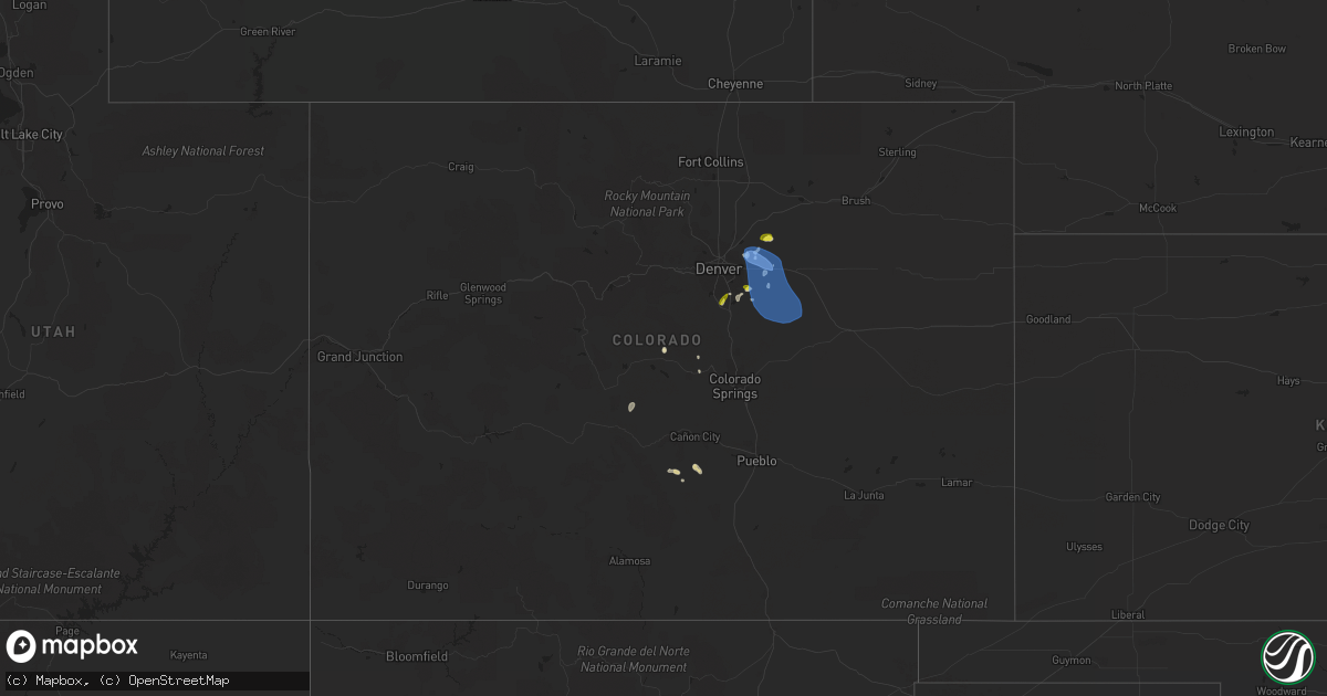
Hail Map in Colorado on July 22, 2019
Get this storm
July 22 map
$229
one time, instant access
Download today. No call, no setup
Keep the $229
Bought the map and want the full workflow? Apply the entire $229 to a subscription within 7 days. None of it is wasted.
Every map, not just this one
This buys you this map. Subscription and you get every map we run, in the markets you choose from a few cities to whole states to nationwide. Plus real-time alerts the moment a storm fires.
Contact data
Name, contact info, occupancy, even credit band for addresses in the footprint. You go from where it hit to who to call.
Become the source they trust
Unlimited branding weather history reports on demand. You already have the documented answer ready for the property owner, and you are the one who showed up with it.
Property data and RoofTrace estimates
Pull up any address you have got, its value and the exact code rules for that jurisdiction, straight from One Click Code. Then RoofTrace estimates the squares, pitch, and roof value, priced the way you price.
Storm reports in Colorado
Colorado
| Date | Description |
|---|---|
| 07/22/20196:52 PM CDT | A local report indicates 1.00 inch wind near 5 SW PROSPECT VALLEY |
| 07/22/20196:08 PM CDT | A local report indicates 79 MPH wind near DENVER INTL AIRPORT |
| 07/22/20196:02 PM CDT | A local report indicates 1.00 inch wind near 5 SE AURORA |
| 07/22/20195:58 PM CDT | Mesonet station stoc2 strm king mt... Glnwood 4nw. |
| 07/22/20194:55 PM CDT | Mesonet station co101 basalt. |
| 07/22/201912:52 AM CDT | At 552 PM MDT, a severe thunderstorm was located 7 miles southwest of Prospect Valley, or 31 miles northeast of Denver, moving east at 15 mph. HAZARD...60 mph wind gusts and quarter size hail. SOURCE...Radar indicated. IMPACT...Expect damage to roofs, siding, and trees. Hail damage to vehicles is expected. Locations impacted include... Prospect Valley. |
| 07/22/201912:41 AM CDT | At 541 PM MDT, a severe thunderstorm was located over Junkins Burn Scar, moving southeast at 15 mph. HAZARD...60 mph wind gusts and half dollar size hail. SOURCE...Radar indicated. IMPACT...Hail damage to vehicles is expected. Expect wind damage to roofs, siding, and trees. Locations impacted include... Junkins Burn Scar and Beulah. |
| 07/22/201912:16 AM CDT | At 516 PM MDT, a severe thunderstorm was located over southeastern Highlands Ranch, or 15 miles south of Denver, moving southwest at 15 mph. HAZARD...60 mph wind gusts and quarter size hail. SOURCE...Radar indicated. IMPACT...Expect damage to roofs, siding, and trees. Hail damage to vehicles is expected. Locations impacted include... Southwestern Centennial, Highlands Ranch, northwestern Castle Rock, southwestern Parker, Lone Tree, Roxborough Park, Castle Pines, Louviers and Sedalia. |
| 07/22/201912:07 AM CDT | At 506 PM MDT, a severe thunderstorm was located over southern Aurora, or 18 miles southeast of Denver, moving southeast at 15 mph. HAZARD...60 mph wind gusts and quarter size hail. SOURCE...Public. IMPACT...Expect damage to roofs, siding, and trees. Hail damage to vehicles is expected. Locations impacted include... Southern Aurora, southeastern Centennial, eastern Parker and Ponderosa Park. |
All States Impacted by Hail Map on July 22, 2019
Cities Impacted by Hail Map on July 22, 2019
- Jamaica, NY
- Beach Haven, NJ
- Manahawkin, NJ
- Garrett, WY
- Lake George, CO
- Cleburne, TX
- Burleson, TX
- San Saba, TX
- Globe, AZ
- Waldwick, NJ
- Allendale, NJ
- Wyckoff, NJ
- Wayne, NJ
- Ramsey, NJ
- Haskell, NJ
- Pompton Plains, NJ
- Oakland, NJ
- Bloomingdale, NJ
- Butler, NJ
- Saddle River, NJ
- Riverdale, NJ
- Lincoln Park, NJ
- Boonton, NJ
- Pompton Lakes, NJ
- Mahwah, NJ
- Towaco, NJ
- Franklin Lakes, NJ
- Merry Hill, NC
- Colerain, NC
- Locust Hill, VA
- Topping, VA
- Saluda, VA
- Gloucester, VA
- Kew Gardens, NY
- Oakland Gardens, NY
- Saint Albans, NY
- Woodmere, NY
- Far Rockaway, NY
- Hewlett, NY
- Rosedale, NY
- Malverne, NY
- Great Neck, NY
- New Hyde Park, NY
- Fresh Meadows, NY
- Glen Oaks, NY
- Cedarhurst, NY
- Lynbrook, NY
- Forest Hills, NY
- Flushing, NY
- Floral Park, NY
- Garden City, NY
- Little Neck, NY
- Lawrence, NY
- Elmont, NY
- South Richmond Hill, NY
- Springfield Gardens, NY
- Queens Village, NY
- South Ozone Park, NY
- Bellerose, NY
- Inwood, NY
- Cambria Heights, NY
- Richmond Hill, NY
- Bayside, NY
- Hollis, NY
- Valley Stream, NY
- Arverne, NY
- Wetmore, CO
- Westcliffe, CO
- Thermopolis, WY
- Disputanta, VA
- Vail, AZ
- Vineland, NJ
- Joshua, TX
- Alvarado, TX
- Keene, TX
- Purdys, NY
- Suffolk, VA
- Franklin, VA
- Franklin, TX
- Crowheart, WY
- White Stone, VA
- Toano, VA
- Williamsburg, VA
- Shacklefords, VA
- Barhamsville, VA
- Weems, VA
- Aberdeen, MD
- Aberdeen Proving Ground, MD
- Pavillion, WY
- Shoshoni, WY
- Miami, AZ
- Wingo, KY
- Water Valley, KY
- Woodcliff Lake, NJ
- Hibernia, NJ
- Randolph, NJ
- Ledgewood, NJ
- Budd Lake, NJ
- Denville, NJ
- Hopatcong, NJ
- Mount Arlington, NJ
- Stanhope, NJ
- Chester, NJ
- West Milford, NJ
- Lake Hopatcong, NJ
- Long Valley, NJ
- Flanders, NJ
- Monsey, NY
- Montvale, NJ
- Montville, NJ
- Dover, NJ
- Rockaway, NJ
- Wanaque, NJ
- Spring Valley, NY
- Mine Hill, NJ
- Midland Park, NJ
- Kenvil, NJ
- Netcong, NJ
- Landing, NJ
- Hackettstown, NJ
- Port Murray, NJ
- Succasunna, NJ
- Wharton, NJ
- Prince George, VA
- Spring Grove, VA
- Emory, TX
- Oxford, NJ
- Great Meadows, NJ
- Belvidere, NJ
- Charles City, VA
- Riner, VA
- Christiansburg, VA
- Westfield, NJ
- Clark, NJ
- Scotch Plains, NJ
- Divide, CO
- Broaddus, TX
- Tucson, AZ
- Conway, NC
- Twentynine Palms, CA
- Joshua Tree, CA
- Darby, MT
- Corsicana, TX
- Barry, TX
- Peridot, AZ
- Sonoita, AZ
- Trexlertown, PA
- Allentown, PA
- Alburtis, PA
- Mertztown, PA
- Breinigsville, PA
- Macungie, PA
- Keenesburg, CO
- Hudson, CO
- Normangee, TX
- McLeod, MT
- Saint David, AZ
- Lolo, MT
- Florence, MT
- Casper, WY
- Myerstown, PA
- Fredericksburg, PA
- Bethel, PA
- Hamilton, TX
- Jonesboro, TX
- Egg Harbor Township, NJ
- Absecon, NJ
- Pleasantville, NJ
- Sierra Vista, AZ
- Hereford, AZ
- Kilmarnock, VA
- Lutherville Timonium, MD
- Towson, MD
- Payson, AZ
- Lander, WY
- Kearny, NJ
- Newark, NJ
- North Arlington, NJ
- Belleville, NJ
- Newark, DE
- Elkton, MD
- Riverton, WY
- Watkins, CO
- Commerce City, CO
- Aurora, CO
- Young, AZ
- New Church, VA
- Pocomoke City, MD
- Old Westbury, NY
- Howard, CO
- Salida, CO
- Mountainside, NJ
- New Providence, NJ
- Summit, NJ
- Springfield, NJ
- Townsend, DE
- Parker, CO
- Middletown, DE
- Port Penn, DE
- Loving, NM
- Gladstone, VA
- Carlsbad, NM
- Landenberg, PA
- Avondale, PA
- Millville, NJ
- Petersburg, VA
- Rayville, LA
- Mangham, LA
- Williamston, NC
- Staten Island, NY
- Chadds Ford, PA
- Kennett Square, PA
- Toughkenamon, PA
- Washington, NJ
- Somerset, NJ
- New Brunswick, NJ
- Piscataway, NJ
- Galena, MD
- Edenton, NC
- Sells, AZ
- South Bay, FL
- Belle Glade, FL
- Rockville, MD
- Kensington, MD
- Garrett Park, MD
- Chevy Chase, MD
- Silver Spring, MD
- Potomac, MD
- Glen Echo, MD
- Bethesda, MD
- Cabin John, MD
- Moonachie, NJ
- Palisades Park, NJ
- Carlstadt, NJ
- East Rutherford, NJ
- Secaucus, NJ
- Little Ferry, NJ
- Ridgefield, NJ
- Ridgefield Park, NJ
- Brooklyn, NY
- Ringwood, NJ
- McNeal, AZ
- Murfreesboro, NC
- Pendleton, NC
- Woodbine, NJ
- Stockton, MD
- Girdletree, MD
- Bisbee, AZ
- Cody, WY
- Bloomfield, NJ
- East Orange, NJ
- Windsor, NC
- Township Of Washington, NJ
- Oradell, NJ
- Harrington Park, NJ
- Paramus, NJ
- Emerson, NJ
- Westwood, NJ
- Lone Tree, CO
- Denver, CO
- Buffalo, TX
- Verona, NJ
- Caldwell, NJ
- Roseland, NJ
- Fairfield, NJ
- Essex Fells, NJ
- Livingston, NJ
- West Orange, NJ
- East Hanover, NJ
- Cedar Grove, NJ
- Delhi, LA
- Winnsboro, LA
- Milmay, NJ
- Port Elizabeth, NJ
- Milford, DE
- Frederica, DE
- Marion Station, MD
- Oak Hall, VA
- Fulton, KY
- Marlin, TX
- East Northport, NY
- Northport, NY
- Saint James, NY
- Kings Park, NY
- East Setauket, NY
- Port Jefferson, NY
- Smithtown, NY
- Commack, NY
- Stony Brook, NY
- Hockessin, DE
- Garnet Valley, PA
- Wilmington, DE
- West Grove, PA
- Glen Mills, PA
- Bennett, CO
- Goldonna, LA
- Greycliff, MT
- Hardyville, VA
- Hartfield, VA
- Wake, VA
- Wading River, NY
- Check, VA
- Pilot, VA
- Floyd, VA
- Gates, NC
- Warner Springs, CA
- Little Falls, NJ
- Paterson, NJ
- Woodlyn, PA
- Swarthmore, PA
- Brookhaven, PA
- Chester, PA
- Wallingford, PA
- Santa Anna, TX
- Tangier, VA
- Andover, NJ
- Lanexa, VA
- Como, NC
- Newsoms, VA
- Jasper, TX
- Zavalla, TX
- Columbia, LA
- Grayson, LA
- Tuckerton, NJ
- West Creek, NJ
- Meadows Of Dan, VA
- Big Sky, MT
- Abingdon, MD
- Mount Vernon, TX
- Pima, AZ
- Amado, AZ
- Green Valley, AZ
- Mascot, VA
- Urbanna, VA
- Church View, VA
- Moneta, VA
- Clinton, KY
- Southside, TN
- Charlotte, TN
- Cumberland Furnace, TN
- Long Branch, NJ
- Folcroft, PA
- Kennedyville, MD
- Somerville, NJ
- Columbus, NJ
- Middle Village, NY
- Mastic Beach, NY
- Brightwaters, NY
- Deal, NJ
- Cranbury, NJ
- Merrick, NY
- Pennsauken, NJ
- Robbinsville, NJ
- Dayton, NJ
- Woodbridge, NJ
- Freehold, NJ
- Sayville, NY
- Drexel Hill, PA
- Basking Ridge, NJ
- Bradley Beach, NJ
- Perryville, MD
- West Berlin, NJ
- Monroeville, NJ
- Buckeystown, MD
- Saint Georges, DE
- Jefferson, MD
- Carteret, NJ
- Millington, MD
- Plainfield, NJ
- Mickleton, NJ
- Middlesex, NJ
- Ranson, WV
- Fanwood, NJ
- Allenwood, NJ
- Millstone Township, NJ
- Spotswood, NJ
- Springfield, PA
- Folsom, PA
- Mount Airy, MD
- Hainesport, NJ
- Pedricktown, NJ
- Marlton, NJ
- Sicklerville, NJ
- Warwick, MD
- Round Hill, VA
- Colonia, NJ
- Lincroft, NJ
- Rockville Centre, NY
- Bayport, NY
- Mantua, NJ
- Marriottsville, MD
- Bellmawr, NJ
- East Meadow, NY
- Red Bank, NJ
- Wrightstown, NJ
- Mullica Hill, NJ
- Oaklyn, NJ
- Holbrook, NY
- Massapequa, NY
- Trenton, NJ
- Marlboro, NJ
- Plainsboro, NJ
- Ozone Park, NY
- Brentwood, NY
- Elk Mills, MD
- Roselle Park, NJ
- Keyport, NJ
- Berryville, VA
- Rahway, NJ
- Lindenhurst, NY
- Manchester Township, NJ
- Aston, PA
- Mount Royal, NJ
- Oakdale, NY
- Oceanport, NJ
- Hillsborough, NJ
- Union, NJ
- Odessa, DE
- Sparks Glencoe, MD
- Beachwood, NJ
- Gaithersburg, MD
- Palmyra, NJ
- Essington, PA
- Matawan, NJ
- Great River, NY
- Roselle, NJ
- Cochranville, PA
- Lakehurst, NJ
- Farmingdale, NY
- Farmingdale, NJ
- Oxford, PA
- Fair Haven, NJ
- Fallston, MD
- Bala Cynwyd, PA
- Avon By The Sea, NJ
- Blackwood, NJ
- Germantown, MD
- Haddonfield, NJ
- Long Island City, NY
- Franklin Park, NJ
- Cecilton, MD
- Islip, NY
- Chesapeake City, MD
- Far Hills, NJ
- Riverside, NJ
- Haddon Heights, NJ
- Phoenix, MD
- Gibbsboro, NJ
- Brunswick, MD
- Breezy Point, NY
- Audubon, NJ
- Burlington, NJ
- Magnolia, NJ
- Old Bridge, NJ
- New Castle, DE
- Fords, NJ
- Atlantic Highlands, NJ
- Levittown, PA
- Iselin, NJ
- Bethpage, NY
- Ijamsville, MD
- Stratford, NJ
- Windsor, NJ
- Summit Point, WV
- Mastic, NY
- Pikesville, MD
- Lansdowne, PA
- Sayreville, NJ
- Parkton, MD
- Thorofare, NJ
- Salem, NJ
- Lovettsville, VA
- Belford, NJ
- Oceanside, NY
- Rego Park, NY
- Jarrettsville, MD
- Woodbury Heights, NJ
- Glendora, NJ
- Ocean Beach, NY
- Darby, PA
- North Brunswick, NJ
- West Islip, NY
- Neptune, NJ
- White Hall, MD
- Ronkonkoma, NY
- Manville, NJ
- Shrewsbury, NJ
- Seaside Heights, NJ
- Point Lookout, NY
- Freeport, NY
- Bristol, PA
- Upper Darby, PA
- Knoxville, MD
- Morrisville, PA
- Chesterfield, NJ
- Prospect Park, PA
- Keasbey, NJ
- Marcus Hook, PA
- Quarryville, PA
- Berkeley Heights, NJ
- Owings Mills, MD
- Clear Brook, VA
- Beverly, NJ
- Ridley Park, PA
- Bordentown, NJ
- Purcellville, VA
- Harpers Ferry, WV
- Cream Ridge, NJ
- Pennsville, NJ
- Little Silver, NJ
- South Bound Brook, NJ
- Babylon, NY
- Highland Park, NJ
- Lincoln University, PA
- National Park, NJ
- Fairless Hills, PA
- Cherry Hill, NJ
- New York, NY
- Bel Air, MD
- Highlands, NJ
- Baldwin, MD
- Pitman, NJ
- Clementon, NJ
- Sewell, NJ
- Waterford, VA
- Cranford, NJ
- Chestertown, MD
- Perth Amboy, NJ
- Califon, NJ
- Brielle, NJ
- Whiteford, MD
- Helmetta, NJ
- Monrovia, MD
- Joint Base Mdl, NJ
- Conowingo, MD
- North East, MD
- Riverton, NJ
- Roebling, NJ
- Center Moriches, NY
- Millington, NJ
- Gladstone, NJ
- New Egypt, NJ
- Camden, NJ
- Cheltenham, PA
- Jersey City, NJ
- South Plainfield, NJ
- Somerdale, NJ
- Island Park, NY
- Asbury Park, NJ
- Martinsville, NJ
- Bensalem, PA
- Glenolden, PA
- Reisterstown, MD
- Sewaren, NJ
- Brick, NJ
- Bridgewater, NJ
- Thornton, PA
- Mantoloking, NJ
- Berlin, NJ
- Levittown, NY
- Voorhees, NJ
- Williamstown, NJ
- Pine Beach, NJ
- Middletown, NJ
- Hempstead, NY
- Hazlet, NJ
- Upperco, MD
- Howard Beach, NY
- Wenonah, NJ
- Parlin, NJ
- Brookhaven, NY
- Deer Park, NY
- Mount Ephraim, NJ
- Paulsboro, NJ
- Pylesville, MD
- Bound Brook, NJ
- Woodstock, MD
- Barnesville, MD
- Penns Grove, NJ
- Street, MD
- Pemberton, NJ
- Cliffwood, NJ
- New Market, MD
- Clarksboro, NJ
- Sea Girt, NJ
- Amityville, NY
- Blue Point, NY
- Gibbstown, NJ
- Glyndon, MD
- West Long Branch, NJ
- Port Reading, NJ
- Browns Mills, NJ
- East Rockaway, NY
- Point Of Rocks, MD
- Crum Lynne, PA
- Bellmore, NY
- South River, NJ
- Clifton Heights, PA
- Elizabeth, NJ
- Allentown, NJ
- Bay Shore, NY
- Massey, MD
- Leonardo, NJ
- Broomall, PA
- New Windsor, MD
- Peapack, NJ
- Adamstown, MD
- Medford, NJ
- Glassboro, NJ
- Claymont, DE
- Media, PA
- Woodstown, NJ
- Bellport, NY
- Watchung, NJ
- Ocean Grove, NJ
- Hillside, NJ
- Grenloch, NJ
- Seaford, NY
- Kendall Park, NJ
- Runnemede, NJ
- Metuchen, NJ
- Finksburg, MD
- Bayonne, NJ
- Woodbury, NJ
- Woodside, NY
- Clarksburg, MD
- Charlestown, MD
- Linden, NJ
- West Babylon, NY
- Central Islip, NY
- Woodhaven, NY
- Cockeysville, MD
- Edison, NJ
- Merchantville, NJ
- Brookeville, MD
- Swedesboro, NJ
- Maspeth, NY
- Charles Town, WV
- Bear, DE
- Holtsville, NY
- Elmhurst, NY
- Leesburg, VA
- Massapequa Park, NY
- Peach Bottom, PA
- Mount Laurel, NJ
- Englishtown, NJ
- Bohemia, NY
- Seaside Park, NJ
- Dunellen, NJ
- Roosevelt, NJ
- Georgetown, MD
- Westville, NJ
- Morganville, NJ
- Whitehouse Station, NJ
- Ocean Gate, NJ
- Kenilworth, NJ
- Princeton, NJ
- Millville, WV
- Earleville, MD
- Atlantic Beach, NY
- Belmar, NJ
- Boyds, MD
- Lawrence Township, NJ
- East Islip, NY
- Franklin Square, NY
- Dickerson, MD
- Monkton, MD
- Warren, NJ
- Lakewood, NJ
- Glenwood, MD
- West Sayville, NY
- Baldwin, NY
- Randallstown, MD
- Howell, NJ
- Mount Holly, NJ
- Philadelphia, PA
- Hunt Valley, MD
- Jackson, NJ
- Copiague, NY
- Norwood, PA
- Point Pleasant Beach, NJ
- Monmouth Beach, NJ
- Cooksville, MD
- Island Heights, NJ
- Colts Neck, NJ
- Florence, NJ
- Bedminster, NJ
- Morton, PA
- Vincentown, NJ
- Lawnside, NJ
- Croydon, PA
- Moriches, NY
- Princeton Junction, NJ
- Drumore, PA
- Manasquan, NJ
- Merion Station, PA
- Holmes, PA
- Rising Sun, MD
- Damascus, MD
- Woodbine, MD
- Monroe Township, NJ
- Stephenson, VA
- Bayville, NJ
- Kirkwood, PA
- Collingswood, NJ
- Stirling, NJ
- Port Deposit, MD
- Eatontown, NJ
- Patchogue, NY
- Bernardsville, NJ
- South Amboy, NJ
- Stevenson, MD
- Rumson, NJ
- Ridgewood, NY
- Montchanin, DE
- Rockaway Park, NY
- Port Monmouth, NJ
- Colora, MD
- Raritan, NJ
- Islip Terrace, NY
- Rockland, DE
- Lumberton, NJ
- East Brunswick, NJ
- Maple Shade, NJ
- West Chester, PA
- Keansburg, NJ
- Monmouth Junction, NJ
- Delaware City, DE
- Oakhurst, NJ
- Langhorne, PA
- Forest Hill, MD
- Willingboro, NJ
- Barrington, NJ
- Garwood, NJ
- Rancocas, NJ
- Wantagh, NY
- Gloucester City, NJ
- Bridgeport, NJ
- North Babylon, NY
- Havertown, PA
- West Friendship, MD
- Westminster, MD
- Frederick, MD
- Boyce, VA
- Avenel, NJ
- Elizabethport, NJ
- Toms River, NJ
- Uniondale, NY
- Sykesville, MD
- Sharon Hill, PA
- Jobstown, NJ
- Winchester, VA
- Cookstown, NJ
- Yorklyn, DE
- Delta, PA
- Tuscarora, MD
- Roosevelt, NY
- Allenhurst, NJ
- Hightstown, NJ
- Milltown, NJ
- Shirley, NY
- Wynnewood, PA
- Moorestown, NJ
- West Hempstead, NY
- Long Beach, NY
- Fort Monmouth, NJ
- Nottingham, PA
- Lavallette, NJ
- Darlington, MD
- Holmdel, NJ
- Chester Heights, PA
- Spring Lake, NJ
- Stephens City, VA
- Vienna, VA
- McLean, VA
- Great Falls, VA
- Greentown, PA
- Hawley, PA
- Dingmans Ferry, PA
- Milford, PA
- Kutztown, PA
- Whitehall, PA
- Orefield, PA
- New Tripoli, PA
- Fogelsville, PA
- Blue Ridge, VA
- Goodview, VA
- Shawsville, VA
- Elliston, VA
- Callaway, VA
- Roanoke, VA
- Bent Mountain, VA
- Copper Hill, VA
- Hardy, VA
- Salem, VA
- Vinton, VA
- Boones Mill, VA
- Gordonsville, VA
- Troy, VA
- Palmyra, VA
- Skipwith, VA
- Chase City, VA
- Portsmouth, VA
- Chesapeake, VA
- Carrsville, VA
- Windsor, VA
- Blackstone, VA
- Kenbridge, VA
- Crewe, VA
- Courtland, VA
- Waverly, VA
- Hallwood, VA
- Chincoteague Island, VA
- Temperanceville, VA
- Princess Anne, MD
- Dagsboro, DE
- Millville, DE
- Eden, MD
- Millsboro, DE
- Quantico, MD
- Willards, MD
- Crisfield, MD
- Bethany Beach, DE
- Delmar, DE
- Whaleyville, MD
- Sanford, VA
- Fenwick Island, DE
- Tyaskin, MD
- Greenbackville, VA
- Ocean City, MD
- Berlin, MD
- Westover, MD
- Newark, MD
- Ocean View, DE
- Deal Island, MD
- Salisbury, MD
- Selbyville, DE
- Parsonsburg, MD
- Delmar, MD
- Frankford, DE
- Bishopville, MD
- Fruitland, MD
- Snow Hill, MD
- Pittsville, MD
- Showell, MD
- Haledon, NJ
- Deer Trail, CO
- Strasburg, CO
- Agate, CO
- Kiowa, CO
- Elizabeth, CO
- Ramah, CO
- Littleton, CO


