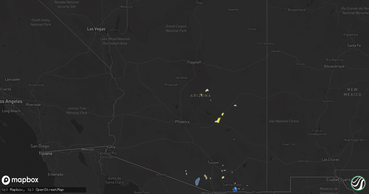
Hail Map in Arizona on July 22, 2019
Get this storm
July 22 map
$229
one time, instant access
Download today. No call, no setup
Keep the $229
Bought the map and want the full workflow? Apply the entire $229 to a subscription within 7 days. None of it is wasted.
Every map, not just this one
This buys you this map. Subscription and you get every map we run, in the markets you choose from a few cities to whole states to nationwide. Plus real-time alerts the moment a storm fires.
Contact data
Name, contact info, occupancy, even credit band for addresses in the footprint. You go from where it hit to who to call.
Become the source they trust
Unlimited branding weather history reports on demand. You already have the documented answer ready for the property owner, and you are the one who showed up with it.
Property data and RoofTrace estimates
Pull up any address you have got, its value and the exact code rules for that jurisdiction, straight from One Click Code. Then RoofTrace estimates the squares, pitch, and roof value, priced the way you price.
Storm reports in Arizona
Arizona
| Date | Description |
|---|---|
| 07/22/20196:30 PM CDT | 67 mph gust recorded at the sasabe raws observation site. Time of occurrence is estimated from radar. |
| 07/22/20196:20 PM CDT | Downed power lines reported on social media. |
| 07/22/20195:02 PM CDT | Downed power lines reported from the public in the area. |
| 07/22/20192:18 AM CDT | At 717 PM MST, a severe thunderstorm was located 10 miles east of Florence, moving west at 35 mph. HAZARD...60 mph wind gusts. SOURCE...Radar indicated. IMPACT...Expect damage to roofs, siding, and trees. Locations impacted include... Casa Grande, Apache Junction, Florence, Coolidge, Gold Canyon, Queen Creek, La Palma, Blackwater, Gold Camp, Magma, San Tan Valley, Coolidge Airport, Florence Junction, Queen Valley and Kings Ranch. |
| 07/22/20191:48 AM CDT | At 647 PM MST, a severe thunderstorm was located 12 miles southwest of Santa Rosa, or 26 miles northwest of Sells, moving northwest at 35 mph. HAZARD...70 mph wind gusts and penny size hail. SOURCE...Radar indicated. IMPACT...Expect considerable tree damage. Damage is likely to mobile homes, roofs, and outbuildings. Locations impacted include... Santa Rosa, Pisinemo, Gu Vo, Hickiwan, Covered Wells, Anegam, Gu Oidak, San Simon, Palo Verde Stand, Ventana, Ak Chin, No:ligk, Vaya Chin, Cababi, San Luis - Sells District, Santa Cruz, Mountain Village, San Luis, Rincon and Kupk.This includes Route 86 between mile markers 65 and 110. |
| 07/22/20191:44 AM CDT | At 643 PM MST, a severe thunderstorm was located near Oracle, moving west at 15 mph. HAZARD...60 mph wind gusts and penny size hail. SOURCE...Radar indicated. IMPACT...Expect damage to roofs, siding, and trees. Locations impacted include... Oracle, San Manuel and Campo Bonito. This includes Route 77 between mile markers 100 and 110. |
| 07/22/20191:32 AM CDT | At 632 PM MST, a severe thunderstorm was located near Tucson International Airport, or near Davis-Monthan Air Force Base, moving west at 25 mph. Davis-Monthan Air Force Base reported a wind gust of 66 mph. HAZARD...70 mph wind gusts and nickel size hail. SOURCE...Radar indicated. IMPACT...Expect considerable tree damage. Damage is likely to mobile homes, roofs, and outbuildings. Locations impacted include... Tucson, Sahuarita, Davis-Monthan Air Force Base, Drexel Heights, Tanque Verde, Vail, South Tucson, Pascua Pueblo Yaqui Reservation, Summit, Tucson International Airport, Saguaro National Park East, Tucson Estates, Valencia West, Catalina Foothills, Rita Ranch and San Xavier Mission.This includes the following highways... Interstate 10 between mile markers 257 and 280. Interstate 19 between mile markers 48 and 63. Route 86 between mile markers 165 and 171. |
| 07/22/20191:27 AM CDT | At 626 PM MST, a severe thunderstorm was located over Globe, moving southwest at 15 mph. HAZARD...60 mph wind gusts. SOURCE...Radar indicated. IMPACT...Expect damage to roofs, siding, and trees. Locations impacted include... Globe, Miami, Top Of The World, Central Heights-Midland City, Top-Of-The-World, Claypool and Inspiration. |
| 07/22/20191:23 AM CDT | At 621 PM MST, a severe thunderstorm was located 5 miles north of Klondike, moving southwest at 15 mph. Also, a very strong outflow has moved off the Mogollon Rim and is headed to the southwest and recently crossed route 70. HAZARD...70 mph wind gusts and quarter size hail. SOURCE...Radar indicated. IMPACT...Hail damage to vehicles is expected. Expect considerable tree damage. Wind damage is also likely to mobile homes, roofs, and outbuildings. Locations impacted include... Aravaipa Canyon Wilderness, Bylas, Fort Thomas, Calva, Klondyke and San Carlos Reservoir.This includes Route 70 between mile markers 280 and 311. |
| 07/22/201912:52 AM CDT | At 552 PM MST, a severe thunderstorm was located over Central Heights-Midland City, or over Globe, moving southwest at 15 mph. HAZARD...60 mph wind gusts and quarter size hail. SOURCE...Radar indicated. IMPACT...Hail damage to vehicles is expected. Expect wind damage to roofs, siding, and trees. Locations impacted include... Globe, Miami, Top Of The World, Cutter, Central Heights-Midland City, Top-Of-The-World, Claypool and Inspiration. |
| 07/22/201912:31 AM CDT | At 530 PM MST, a severe thunderstorm was located near Dragoon, or 14 miles southwest of Willcox, moving west at 15 mph. This is right over I-10 and could cause damage to vehicles and force high profile vehicles off the road. HAZARD...60 mph wind gusts and nickel size hail. SOURCE...Radar indicated. IMPACT...Expect damage to roofs, siding, and trees. Locations impacted include... Dragoon, Cochise and Texas Canyon. This includes the following highways... Interstate 10 between mile markers 310 and 332. Route 191 between mile markers 58 and 61, and between mile markers64 and 66. |
| 07/22/201912:11 AM CDT | At 511 PM MST, a severe thunderstorm was located over Payson, and is nearly stationary. HAZARD...60 mph wind gusts and quarter size hail. SOURCE...Radar indicated. IMPACT...Hail damage to vehicles is expected. Expect wind damage to roofs, siding, and trees. Locations impacted include... Payson, Flowing Springs, East Verde Estates, Mesa Del Caballo and Houston Mesa Campground. |
| 07/21/201911:22 PM CDT | At 421 PM MST, a severe thunderstorm was located near Saguaro National Park East, or 11 miles east of Davis-Monthan Air Force Base, moving west at 15 mph. HAZARD...60 mph wind gusts and penny size hail along with very heavy rain. SOURCE...Radar indicated. IMPACT...Expect damage to roofs, siding, and trees. Locations impacted include... East Tucson, Tanque Verde, Saguaro National Park East and Rita Ranch. This includes Interstate 10 between mile markers 272 and 275. |
| 07/21/201911:18 PM CDT | At 417 PM MST, a severe thunderstorm was located 10 miles south of Young, or 22 miles northeast of Roosevelt, and is nearly stationary. HAZARD...60 mph wind gusts and penny size hail. SOURCE...Radar indicated. IMPACT...Expect damage to roofs, siding, and trees. This severe thunderstorm will remain over mainly rural areas of Gila County. |
| 07/21/201910:56 PM CDT | At 356 PM MST, a severe thunderstorm was located 9 miles northwest of Patagonia, or 11 miles east of Tubac, moving west at 20 mph. HAZARD...60 mph wind gusts and quarter size hail. SOURCE...Radar indicated. IMPACT...Hail damage to vehicles is expected. Expect wind damage to roofs, siding, and trees. Locations impacted include... Sahuarita, Green Valley, Tubac, Patagonia, Sonoita, Tumacacori, Amado, Madera Canyon and Arivaca Junction.This includes the following highways... Interstate 19 between mile markers 18 and 41. Route 82 between mile markers 17 and 33. Route 83 between mile markers 31 and 43. |
| 07/21/201910:41 PM CDT | At 341 PM MST, a severe thunderstorm was located near Whetstone, or 13 miles north of Sierra Vista, moving west at 15 mph. HAZARD...60 mph wind gusts and nickel size hail. SOURCE...Radar indicated. IMPACT...Expect damage to roofs, siding, and trees. Locations impacted include... Whetstone, Elgin and Kartchner Caverns State Park. This includes the following highways... Route 82 between mile markers 36 and 58. Route 90 between mile markers 297 and 311. |
| 07/21/201910:31 PM CDT | At 330 PM MST, a severe thunderstorm was located near Nogales International Airport, or 8 miles northeast of Nogales, moving west at 15 mph. HAZARD...60 mph wind gusts and penny size hail along with heavy rain. SOURCE...Radar indicated. IMPACT...Expect damage to roofs, siding, and trees. Locations impacted include... Nogales, Tubac, Rio Rico, Nogales International Airport, Patagonia Lake State Park, Tumacacori, Kino Springs and Pena Blanca Lake.This includes the following highways... Interstate 19 between mile markers 1 and 22. Route 82 between mile markers 1 and 17. |
| 07/21/201910:27 PM CDT | At 325 PM MST, a severe thunderstorm was located near Vail, or 12 miles east of Sahuarita, moving west to northwest at 15 mph. HAZARD...60 mph wind gusts and penny size hail along with heavy rain. SOURCE...Radar indicated. IMPACT...Expect damage to roofs, siding, and trees. Locations impacted include... Southeast Tucson, Sahuarita, Davis-Monthan Air Force Base, Vail, Sahuarita, Corona De Tucson, Saguaro National Park East and Rita Ranch.This includes the following highways... Interstate 10 between mile markers 269 and 291. Route 83 between mile markers 44 and 58. |
| 07/21/201910:05 PM CDT | At 304 PM MST, a severe thunderstorm was located over Hereford, or 9 miles southeast of Sierra Vista, moving west at 25 mph. HAZARD...60 mph wind gusts. Heavy rainfall. SOURCE...Radar indicated. IMPACT...Expect damage to roofs, siding, and trees. Locations impacted include... Sierra Vista, Hereford, Parker Canyon Lake, Fort Huachuca, Palominas, Coronado National Memorial, Canelo and Ramsey Canyon Preserve.This includes the following highways... Route 83 between mile markers 3 and 14. Route 90 between mile markers 317 and 332. Route 92 between mile markers 322 and 340. |
| 07/21/20198:45 PM CDT | Mesonet station qhra3 horse camp. Delayed report. |
| 07/21/20198:26 PM CDT | 65 mph gust recorded on the black hills raws. Time estimated based on satellite. |
| 07/21/20198:17 PM CDT | Dma asos reported 66 mph gust. |
| 07/21/20198:14 PM CDT | A local report indicates 61 MPH wind near 2 NNE SAN CARLOS |
| 07/21/20197:30 PM CDT | A picture of one inch diameter hail was shared on social media from north payson. |
All States Impacted by Hail Map on July 22, 2019
Cities Impacted by Hail Map on July 22, 2019
- Jamaica, NY
- Beach Haven, NJ
- Manahawkin, NJ
- Garrett, WY
- Lake George, CO
- Cleburne, TX
- Burleson, TX
- San Saba, TX
- Globe, AZ
- Waldwick, NJ
- Allendale, NJ
- Wyckoff, NJ
- Wayne, NJ
- Ramsey, NJ
- Haskell, NJ
- Pompton Plains, NJ
- Oakland, NJ
- Bloomingdale, NJ
- Butler, NJ
- Saddle River, NJ
- Riverdale, NJ
- Lincoln Park, NJ
- Boonton, NJ
- Pompton Lakes, NJ
- Mahwah, NJ
- Towaco, NJ
- Franklin Lakes, NJ
- Merry Hill, NC
- Colerain, NC
- Locust Hill, VA
- Topping, VA
- Saluda, VA
- Gloucester, VA
- Kew Gardens, NY
- Oakland Gardens, NY
- Saint Albans, NY
- Woodmere, NY
- Far Rockaway, NY
- Hewlett, NY
- Rosedale, NY
- Malverne, NY
- Great Neck, NY
- New Hyde Park, NY
- Fresh Meadows, NY
- Glen Oaks, NY
- Cedarhurst, NY
- Lynbrook, NY
- Forest Hills, NY
- Flushing, NY
- Floral Park, NY
- Garden City, NY
- Little Neck, NY
- Lawrence, NY
- Elmont, NY
- South Richmond Hill, NY
- Springfield Gardens, NY
- Queens Village, NY
- South Ozone Park, NY
- Bellerose, NY
- Inwood, NY
- Cambria Heights, NY
- Richmond Hill, NY
- Bayside, NY
- Hollis, NY
- Valley Stream, NY
- Arverne, NY
- Wetmore, CO
- Westcliffe, CO
- Thermopolis, WY
- Disputanta, VA
- Vail, AZ
- Vineland, NJ
- Joshua, TX
- Alvarado, TX
- Keene, TX
- Purdys, NY
- Suffolk, VA
- Franklin, VA
- Franklin, TX
- Crowheart, WY
- White Stone, VA
- Toano, VA
- Williamsburg, VA
- Shacklefords, VA
- Barhamsville, VA
- Weems, VA
- Aberdeen, MD
- Aberdeen Proving Ground, MD
- Pavillion, WY
- Shoshoni, WY
- Miami, AZ
- Wingo, KY
- Water Valley, KY
- Woodcliff Lake, NJ
- Hibernia, NJ
- Randolph, NJ
- Ledgewood, NJ
- Budd Lake, NJ
- Denville, NJ
- Hopatcong, NJ
- Mount Arlington, NJ
- Stanhope, NJ
- Chester, NJ
- West Milford, NJ
- Lake Hopatcong, NJ
- Long Valley, NJ
- Flanders, NJ
- Monsey, NY
- Montvale, NJ
- Montville, NJ
- Dover, NJ
- Rockaway, NJ
- Wanaque, NJ
- Spring Valley, NY
- Mine Hill, NJ
- Midland Park, NJ
- Kenvil, NJ
- Netcong, NJ
- Landing, NJ
- Hackettstown, NJ
- Port Murray, NJ
- Succasunna, NJ
- Wharton, NJ
- Prince George, VA
- Spring Grove, VA
- Emory, TX
- Oxford, NJ
- Great Meadows, NJ
- Belvidere, NJ
- Charles City, VA
- Riner, VA
- Christiansburg, VA
- Westfield, NJ
- Clark, NJ
- Scotch Plains, NJ
- Divide, CO
- Broaddus, TX
- Tucson, AZ
- Conway, NC
- Twentynine Palms, CA
- Joshua Tree, CA
- Darby, MT
- Corsicana, TX
- Barry, TX
- Peridot, AZ
- Sonoita, AZ
- Trexlertown, PA
- Allentown, PA
- Alburtis, PA
- Mertztown, PA
- Breinigsville, PA
- Macungie, PA
- Keenesburg, CO
- Hudson, CO
- Normangee, TX
- McLeod, MT
- Saint David, AZ
- Lolo, MT
- Florence, MT
- Casper, WY
- Myerstown, PA
- Fredericksburg, PA
- Bethel, PA
- Hamilton, TX
- Jonesboro, TX
- Egg Harbor Township, NJ
- Absecon, NJ
- Pleasantville, NJ
- Sierra Vista, AZ
- Hereford, AZ
- Kilmarnock, VA
- Lutherville Timonium, MD
- Towson, MD
- Payson, AZ
- Lander, WY
- Kearny, NJ
- Newark, NJ
- North Arlington, NJ
- Belleville, NJ
- Newark, DE
- Elkton, MD
- Riverton, WY
- Watkins, CO
- Commerce City, CO
- Aurora, CO
- Young, AZ
- New Church, VA
- Pocomoke City, MD
- Old Westbury, NY
- Howard, CO
- Salida, CO
- Mountainside, NJ
- New Providence, NJ
- Summit, NJ
- Springfield, NJ
- Townsend, DE
- Parker, CO
- Middletown, DE
- Port Penn, DE
- Loving, NM
- Gladstone, VA
- Carlsbad, NM
- Landenberg, PA
- Avondale, PA
- Millville, NJ
- Petersburg, VA
- Rayville, LA
- Mangham, LA
- Williamston, NC
- Staten Island, NY
- Chadds Ford, PA
- Kennett Square, PA
- Toughkenamon, PA
- Washington, NJ
- Somerset, NJ
- New Brunswick, NJ
- Piscataway, NJ
- Galena, MD
- Edenton, NC
- Sells, AZ
- South Bay, FL
- Belle Glade, FL
- Rockville, MD
- Kensington, MD
- Garrett Park, MD
- Chevy Chase, MD
- Silver Spring, MD
- Potomac, MD
- Glen Echo, MD
- Bethesda, MD
- Cabin John, MD
- Moonachie, NJ
- Palisades Park, NJ
- Carlstadt, NJ
- East Rutherford, NJ
- Secaucus, NJ
- Little Ferry, NJ
- Ridgefield, NJ
- Ridgefield Park, NJ
- Brooklyn, NY
- Ringwood, NJ
- McNeal, AZ
- Murfreesboro, NC
- Pendleton, NC
- Woodbine, NJ
- Stockton, MD
- Girdletree, MD
- Bisbee, AZ
- Cody, WY
- Bloomfield, NJ
- East Orange, NJ
- Windsor, NC
- Township Of Washington, NJ
- Oradell, NJ
- Harrington Park, NJ
- Paramus, NJ
- Emerson, NJ
- Westwood, NJ
- Lone Tree, CO
- Denver, CO
- Buffalo, TX
- Verona, NJ
- Caldwell, NJ
- Roseland, NJ
- Fairfield, NJ
- Essex Fells, NJ
- Livingston, NJ
- West Orange, NJ
- East Hanover, NJ
- Cedar Grove, NJ
- Delhi, LA
- Winnsboro, LA
- Milmay, NJ
- Port Elizabeth, NJ
- Milford, DE
- Frederica, DE
- Marion Station, MD
- Oak Hall, VA
- Fulton, KY
- Marlin, TX
- East Northport, NY
- Northport, NY
- Saint James, NY
- Kings Park, NY
- East Setauket, NY
- Port Jefferson, NY
- Smithtown, NY
- Commack, NY
- Stony Brook, NY
- Hockessin, DE
- Garnet Valley, PA
- Wilmington, DE
- West Grove, PA
- Glen Mills, PA
- Bennett, CO
- Goldonna, LA
- Greycliff, MT
- Hardyville, VA
- Hartfield, VA
- Wake, VA
- Wading River, NY
- Check, VA
- Pilot, VA
- Floyd, VA
- Gates, NC
- Warner Springs, CA
- Little Falls, NJ
- Paterson, NJ
- Woodlyn, PA
- Swarthmore, PA
- Brookhaven, PA
- Chester, PA
- Wallingford, PA
- Santa Anna, TX
- Tangier, VA
- Andover, NJ
- Lanexa, VA
- Como, NC
- Newsoms, VA
- Jasper, TX
- Zavalla, TX
- Columbia, LA
- Grayson, LA
- Tuckerton, NJ
- West Creek, NJ
- Meadows Of Dan, VA
- Big Sky, MT
- Abingdon, MD
- Mount Vernon, TX
- Pima, AZ
- Amado, AZ
- Green Valley, AZ
- Mascot, VA
- Urbanna, VA
- Church View, VA
- Moneta, VA
- Clinton, KY
- Southside, TN
- Charlotte, TN
- Cumberland Furnace, TN
- Long Branch, NJ
- Folcroft, PA
- Kennedyville, MD
- Somerville, NJ
- Columbus, NJ
- Middle Village, NY
- Mastic Beach, NY
- Brightwaters, NY
- Deal, NJ
- Cranbury, NJ
- Merrick, NY
- Pennsauken, NJ
- Robbinsville, NJ
- Dayton, NJ
- Woodbridge, NJ
- Freehold, NJ
- Sayville, NY
- Drexel Hill, PA
- Basking Ridge, NJ
- Bradley Beach, NJ
- Perryville, MD
- West Berlin, NJ
- Monroeville, NJ
- Buckeystown, MD
- Saint Georges, DE
- Jefferson, MD
- Carteret, NJ
- Millington, MD
- Plainfield, NJ
- Mickleton, NJ
- Middlesex, NJ
- Ranson, WV
- Fanwood, NJ
- Allenwood, NJ
- Millstone Township, NJ
- Spotswood, NJ
- Springfield, PA
- Folsom, PA
- Mount Airy, MD
- Hainesport, NJ
- Pedricktown, NJ
- Marlton, NJ
- Sicklerville, NJ
- Warwick, MD
- Round Hill, VA
- Colonia, NJ
- Lincroft, NJ
- Rockville Centre, NY
- Bayport, NY
- Mantua, NJ
- Marriottsville, MD
- Bellmawr, NJ
- East Meadow, NY
- Red Bank, NJ
- Wrightstown, NJ
- Mullica Hill, NJ
- Oaklyn, NJ
- Holbrook, NY
- Massapequa, NY
- Trenton, NJ
- Marlboro, NJ
- Plainsboro, NJ
- Ozone Park, NY
- Brentwood, NY
- Elk Mills, MD
- Roselle Park, NJ
- Keyport, NJ
- Berryville, VA
- Rahway, NJ
- Lindenhurst, NY
- Manchester Township, NJ
- Aston, PA
- Mount Royal, NJ
- Oakdale, NY
- Oceanport, NJ
- Hillsborough, NJ
- Union, NJ
- Odessa, DE
- Sparks Glencoe, MD
- Beachwood, NJ
- Gaithersburg, MD
- Palmyra, NJ
- Essington, PA
- Matawan, NJ
- Great River, NY
- Roselle, NJ
- Cochranville, PA
- Lakehurst, NJ
- Farmingdale, NY
- Farmingdale, NJ
- Oxford, PA
- Fair Haven, NJ
- Fallston, MD
- Bala Cynwyd, PA
- Avon By The Sea, NJ
- Blackwood, NJ
- Germantown, MD
- Haddonfield, NJ
- Long Island City, NY
- Franklin Park, NJ
- Cecilton, MD
- Islip, NY
- Chesapeake City, MD
- Far Hills, NJ
- Riverside, NJ
- Haddon Heights, NJ
- Phoenix, MD
- Gibbsboro, NJ
- Brunswick, MD
- Breezy Point, NY
- Audubon, NJ
- Burlington, NJ
- Magnolia, NJ
- Old Bridge, NJ
- New Castle, DE
- Fords, NJ
- Atlantic Highlands, NJ
- Levittown, PA
- Iselin, NJ
- Bethpage, NY
- Ijamsville, MD
- Stratford, NJ
- Windsor, NJ
- Summit Point, WV
- Mastic, NY
- Pikesville, MD
- Lansdowne, PA
- Sayreville, NJ
- Parkton, MD
- Thorofare, NJ
- Salem, NJ
- Lovettsville, VA
- Belford, NJ
- Oceanside, NY
- Rego Park, NY
- Jarrettsville, MD
- Woodbury Heights, NJ
- Glendora, NJ
- Ocean Beach, NY
- Darby, PA
- North Brunswick, NJ
- West Islip, NY
- Neptune, NJ
- White Hall, MD
- Ronkonkoma, NY
- Manville, NJ
- Shrewsbury, NJ
- Seaside Heights, NJ
- Point Lookout, NY
- Freeport, NY
- Bristol, PA
- Upper Darby, PA
- Knoxville, MD
- Morrisville, PA
- Chesterfield, NJ
- Prospect Park, PA
- Keasbey, NJ
- Marcus Hook, PA
- Quarryville, PA
- Berkeley Heights, NJ
- Owings Mills, MD
- Clear Brook, VA
- Beverly, NJ
- Ridley Park, PA
- Bordentown, NJ
- Purcellville, VA
- Harpers Ferry, WV
- Cream Ridge, NJ
- Pennsville, NJ
- Little Silver, NJ
- South Bound Brook, NJ
- Babylon, NY
- Highland Park, NJ
- Lincoln University, PA
- National Park, NJ
- Fairless Hills, PA
- Cherry Hill, NJ
- New York, NY
- Bel Air, MD
- Highlands, NJ
- Baldwin, MD
- Pitman, NJ
- Clementon, NJ
- Sewell, NJ
- Waterford, VA
- Cranford, NJ
- Chestertown, MD
- Perth Amboy, NJ
- Califon, NJ
- Brielle, NJ
- Whiteford, MD
- Helmetta, NJ
- Monrovia, MD
- Joint Base Mdl, NJ
- Conowingo, MD
- North East, MD
- Riverton, NJ
- Roebling, NJ
- Center Moriches, NY
- Millington, NJ
- Gladstone, NJ
- New Egypt, NJ
- Camden, NJ
- Cheltenham, PA
- Jersey City, NJ
- South Plainfield, NJ
- Somerdale, NJ
- Island Park, NY
- Asbury Park, NJ
- Martinsville, NJ
- Bensalem, PA
- Glenolden, PA
- Reisterstown, MD
- Sewaren, NJ
- Brick, NJ
- Bridgewater, NJ
- Thornton, PA
- Mantoloking, NJ
- Berlin, NJ
- Levittown, NY
- Voorhees, NJ
- Williamstown, NJ
- Pine Beach, NJ
- Middletown, NJ
- Hempstead, NY
- Hazlet, NJ
- Upperco, MD
- Howard Beach, NY
- Wenonah, NJ
- Parlin, NJ
- Brookhaven, NY
- Deer Park, NY
- Mount Ephraim, NJ
- Paulsboro, NJ
- Pylesville, MD
- Bound Brook, NJ
- Woodstock, MD
- Barnesville, MD
- Penns Grove, NJ
- Street, MD
- Pemberton, NJ
- Cliffwood, NJ
- New Market, MD
- Clarksboro, NJ
- Sea Girt, NJ
- Amityville, NY
- Blue Point, NY
- Gibbstown, NJ
- Glyndon, MD
- West Long Branch, NJ
- Port Reading, NJ
- Browns Mills, NJ
- East Rockaway, NY
- Point Of Rocks, MD
- Crum Lynne, PA
- Bellmore, NY
- South River, NJ
- Clifton Heights, PA
- Elizabeth, NJ
- Allentown, NJ
- Bay Shore, NY
- Massey, MD
- Leonardo, NJ
- Broomall, PA
- New Windsor, MD
- Peapack, NJ
- Adamstown, MD
- Medford, NJ
- Glassboro, NJ
- Claymont, DE
- Media, PA
- Woodstown, NJ
- Bellport, NY
- Watchung, NJ
- Ocean Grove, NJ
- Hillside, NJ
- Grenloch, NJ
- Seaford, NY
- Kendall Park, NJ
- Runnemede, NJ
- Metuchen, NJ
- Finksburg, MD
- Bayonne, NJ
- Woodbury, NJ
- Woodside, NY
- Clarksburg, MD
- Charlestown, MD
- Linden, NJ
- West Babylon, NY
- Central Islip, NY
- Woodhaven, NY
- Cockeysville, MD
- Edison, NJ
- Merchantville, NJ
- Brookeville, MD
- Swedesboro, NJ
- Maspeth, NY
- Charles Town, WV
- Bear, DE
- Holtsville, NY
- Elmhurst, NY
- Leesburg, VA
- Massapequa Park, NY
- Peach Bottom, PA
- Mount Laurel, NJ
- Englishtown, NJ
- Bohemia, NY
- Seaside Park, NJ
- Dunellen, NJ
- Roosevelt, NJ
- Georgetown, MD
- Westville, NJ
- Morganville, NJ
- Whitehouse Station, NJ
- Ocean Gate, NJ
- Kenilworth, NJ
- Princeton, NJ
- Millville, WV
- Earleville, MD
- Atlantic Beach, NY
- Belmar, NJ
- Boyds, MD
- Lawrence Township, NJ
- East Islip, NY
- Franklin Square, NY
- Dickerson, MD
- Monkton, MD
- Warren, NJ
- Lakewood, NJ
- Glenwood, MD
- West Sayville, NY
- Baldwin, NY
- Randallstown, MD
- Howell, NJ
- Mount Holly, NJ
- Philadelphia, PA
- Hunt Valley, MD
- Jackson, NJ
- Copiague, NY
- Norwood, PA
- Point Pleasant Beach, NJ
- Monmouth Beach, NJ
- Cooksville, MD
- Island Heights, NJ
- Colts Neck, NJ
- Florence, NJ
- Bedminster, NJ
- Morton, PA
- Vincentown, NJ
- Lawnside, NJ
- Croydon, PA
- Moriches, NY
- Princeton Junction, NJ
- Drumore, PA
- Manasquan, NJ
- Merion Station, PA
- Holmes, PA
- Rising Sun, MD
- Damascus, MD
- Woodbine, MD
- Monroe Township, NJ
- Stephenson, VA
- Bayville, NJ
- Kirkwood, PA
- Collingswood, NJ
- Stirling, NJ
- Port Deposit, MD
- Eatontown, NJ
- Patchogue, NY
- Bernardsville, NJ
- South Amboy, NJ
- Stevenson, MD
- Rumson, NJ
- Ridgewood, NY
- Montchanin, DE
- Rockaway Park, NY
- Port Monmouth, NJ
- Colora, MD
- Raritan, NJ
- Islip Terrace, NY
- Rockland, DE
- Lumberton, NJ
- East Brunswick, NJ
- Maple Shade, NJ
- West Chester, PA
- Keansburg, NJ
- Monmouth Junction, NJ
- Delaware City, DE
- Oakhurst, NJ
- Langhorne, PA
- Forest Hill, MD
- Willingboro, NJ
- Barrington, NJ
- Garwood, NJ
- Rancocas, NJ
- Wantagh, NY
- Gloucester City, NJ
- Bridgeport, NJ
- North Babylon, NY
- Havertown, PA
- West Friendship, MD
- Westminster, MD
- Frederick, MD
- Boyce, VA
- Avenel, NJ
- Elizabethport, NJ
- Toms River, NJ
- Uniondale, NY
- Sykesville, MD
- Sharon Hill, PA
- Jobstown, NJ
- Winchester, VA
- Cookstown, NJ
- Yorklyn, DE
- Delta, PA
- Tuscarora, MD
- Roosevelt, NY
- Allenhurst, NJ
- Hightstown, NJ
- Milltown, NJ
- Shirley, NY
- Wynnewood, PA
- Moorestown, NJ
- West Hempstead, NY
- Long Beach, NY
- Fort Monmouth, NJ
- Nottingham, PA
- Lavallette, NJ
- Darlington, MD
- Holmdel, NJ
- Chester Heights, PA
- Spring Lake, NJ
- Stephens City, VA
- Vienna, VA
- McLean, VA
- Great Falls, VA
- Greentown, PA
- Hawley, PA
- Dingmans Ferry, PA
- Milford, PA
- Kutztown, PA
- Whitehall, PA
- Orefield, PA
- New Tripoli, PA
- Fogelsville, PA
- Blue Ridge, VA
- Goodview, VA
- Shawsville, VA
- Elliston, VA
- Callaway, VA
- Roanoke, VA
- Bent Mountain, VA
- Copper Hill, VA
- Hardy, VA
- Salem, VA
- Vinton, VA
- Boones Mill, VA
- Gordonsville, VA
- Troy, VA
- Palmyra, VA
- Skipwith, VA
- Chase City, VA
- Portsmouth, VA
- Chesapeake, VA
- Carrsville, VA
- Windsor, VA
- Blackstone, VA
- Kenbridge, VA
- Crewe, VA
- Courtland, VA
- Waverly, VA
- Hallwood, VA
- Chincoteague Island, VA
- Temperanceville, VA
- Princess Anne, MD
- Dagsboro, DE
- Millville, DE
- Eden, MD
- Millsboro, DE
- Quantico, MD
- Willards, MD
- Crisfield, MD
- Bethany Beach, DE
- Delmar, DE
- Whaleyville, MD
- Sanford, VA
- Fenwick Island, DE
- Tyaskin, MD
- Greenbackville, VA
- Ocean City, MD
- Berlin, MD
- Westover, MD
- Newark, MD
- Ocean View, DE
- Deal Island, MD
- Salisbury, MD
- Selbyville, DE
- Parsonsburg, MD
- Delmar, MD
- Frankford, DE
- Bishopville, MD
- Fruitland, MD
- Snow Hill, MD
- Pittsville, MD
- Showell, MD
- Haledon, NJ
- Deer Trail, CO
- Strasburg, CO
- Agate, CO
- Kiowa, CO
- Elizabeth, CO
- Ramah, CO
- Littleton, CO


