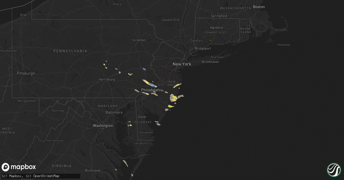
Hail Map in New Jersey on July 21, 2021
Get this storm
July 21 map
$229
one time, instant access
Download today. No call, no setup
Keep the $229
Bought the map and want the full workflow? Apply the entire $229 to a subscription within 7 days. None of it is wasted.
Every map, not just this one
This buys you this map. Subscription and you get every map we run, in the markets you choose from a few cities to whole states to nationwide. Plus real-time alerts the moment a storm fires.
Contact data
Name, contact info, occupancy, even credit band for addresses in the footprint. You go from where it hit to who to call.
Become the source they trust
Unlimited branding weather history reports on demand. You already have the documented answer ready for the property owner, and you are the one who showed up with it.
Property data and RoofTrace estimates
Pull up any address you have got, its value and the exact code rules for that jurisdiction, straight from One Click Code. Then RoofTrace estimates the squares, pitch, and roof value, priced the way you price.
Storm reports in New Jersey
New Jersey
| Date | Description |
|---|---|
| 07/21/20214:36 PM CDT | Wires down on ocean drive in cape may. Time estimated from radar. |
| 07/21/20214:36 PM CDT | Telephone pole snapped in half on w preston ave in wildwood crest. Photo relayed on social media. Time estimated from radar. |
| 07/21/20214:33 PM CDT | Nos site at north cape may measures 58mph gust |
| 07/21/20214:32 PM CDT | Tree down in cape road road in lower township. Time estimated from radar. |
| 07/21/20213:20 PM CDT | A local report indicates 1.00 inch wind near GALLOWAY TWP |
| 07/21/20213:00 PM CDT | Wires down on road in herbertsville... Photo relayed through social media. Time estimated from radar. |
| 07/21/20212:51 PM CDT | Wires down in delanco near border with riverside township/rancocas river. Time estimated from radar. |
| 07/21/20212:50 PM CDT | Large tree limbs down and blocking bridgeboro road near the westfield road intersection in moorestown. Time estimated from radar. |
| 07/21/20212:20 PM CDT | A local report indicates 1.00 inch wind near GLOUCESTER TWP |
| 07/21/20212:20 PM CDT | At laurel springs. |
| 07/21/20212:20 PM CDT | A local report indicates 1.00 inch wind near LAKEHURST |
| 07/21/20212:05 PM CDT | Large branch down on fence in audubon... Photo relayed via social media. Time estimated from radar. |
| 07/21/20211:05 PM CDT | A local report indicates 1.25 inch wind near MANAHAWKIN |
| 07/21/202112:15 PM CDT | A local report indicates 1.00 inch wind near MANAHAWKIN |
| 07/21/202112:05 PM CDT | A local report indicates 1.00 inch wind near STRATFORD |
| 07/21/202112:05 PM CDT | A local report indicates 1.00 inch wind near OCEAN ACRES |
| 07/21/20217:53 AM CDT | At 1253 PM EDT, a severe thunderstorm was located over Barnegat, or 18 miles south of Toms River, moving southeast at 15 mph. HAZARD...60 mph wind gusts and quarter size hail. SOURCE...Radar indicated. IMPACT...Minor damage to vehicles is possible. Wind damage to roofs, siding, trees, and power lines is possible. Locations impacted include... Barnegat, Surf City, Brookville, Warren Grove, Beach Haven West, Manahawkin, Ocean Acres and Waretown.This includes Garden State Parkway between mile markers 61 and 73. |
| 07/21/20217:51 AM CDT | At 1251 PM EDT, a severe thunderstorm was located near Port Republic, or near Atlantic City, moving southeast at 15 mph. HAZARD...60 mph wind gusts and quarter size hail. SOURCE...Radar indicated. IMPACT...Minor damage to vehicles is possible. Wind damage to roofs, siding, trees, and power lines is possible. Locations impacted include... Atlantic City, Pleasantville, Ventnor City, Brigantine, Absecon, Tuckerton, Port Republic, Pomona and Mystic Island.This includes the following highways... Garden State Parkway between mile markers 37 and 43. Atlantic City Expressway between mile markers 0 and 8. |
| 07/21/202112:31 AM CDT | At 531 PM EDT, a severe thunderstorm was located over North Cape May, or near Cape May, moving east at 25 mph. HAZARD...60 mph wind gusts and penny size hail. SOURCE...Radar indicated. IMPACT...Damage to roofs, siding, trees, and power lines is possible. Locations impacted include... Cape May, North Wildwood, Wildwood Crest, Sea Isle City, Avalon, West Cape May, Stone Harbor, Cape May Court House, Scotch Bonnet, Diamond Beach, Green Creek, Rio Grande, North Cape May, Villas, West Wildwood, Erma and Whitesboro-Burleigh.This includes Garden State Parkway between mile markers 0 and 14. |
| 07/20/202110:57 PM CDT | At 357 PM EDT, a severe thunderstorm was located over Paulsboro, or 7 miles southwest of Gloucester City, moving east at 40 mph. HAZARD...60 mph wind gusts and quarter size hail. SOURCE...Radar indicated. IMPACT...Minor damage to vehicles is possible. Wind damage to roofs, siding, trees, and power lines is possible. Locations impacted include... Deptford, Voorhees, West Deptford, Glassboro, Lindenwold, Hammonton, Bellmawr, Woodbury, Pitman, Clayton, Berlin, Tabernacle, Shamong, Paulsboro, Magnolia, Westville, Egg Harbor City, Woodstown, Woodbury Heights and National Park.This includes the following highways... New Jersey Turnpike between exits 2 and 3. Interstate 76 in New Jersey near mile marker 0. Interstate 295 in New Jersey between mile markers 16 and 29. Atlantic City Expressway between mile markers 23 and 44. |
| 07/20/202110:43 PM CDT | At 343 PM EDT, a severe thunderstorm was located over Lakewood, or near Toms River, moving northeast at 25 mph. HAZARD...60 mph wind gusts and quarter size hail. SOURCE...Radar indicated. IMPACT...Minor damage to vehicles is possible. Wind damage to roofs, siding, trees, and power lines is possible. Locations impacted include... Toms River, Long Branch, Asbury Park, Lakewood, Tinton Falls, Manasquan, Point Pleasant Beach, Farmingdale, Mantoloking, Leisure Village, Allenwood, Pleasant Plains, Leisure Village East, Elberon, Ramtown, Brick Township, Collingwood Park, Cedar Glen West, Leisure Village West-Pine Lake Park and Point Pleasant.This includes the following highways... Interstate 195 in New Jersey between mile markers 26 and 34. Garden State Parkway between mile markers 85 and 104. |
| 07/20/20219:52 PM CDT | At 251 PM EDT, a severe thunderstorm was located over Parkesburg, or 12 miles southeast of New Holland, moving east at 30 mph. HAZARD...60 mph wind gusts and quarter size hail. SOURCE...Radar indicated. IMPACT...Minor damage to vehicles is possible. Wind damage to roofs, siding, trees, and power lines is possible. Locations impacted include... West Chester, Chester, Coatesville, Westtown, Downingtown, Parkesburg, Cochranville, Cheyney, Elam, Marshallton, Lima, Chelsea, Radnor Township, Lionville-Marchwood, Gradyville, Paoli, Newtown Square, Chester Township, Lionville and Concordville.This includes the following highways... Interstate 95 in Pennsylvania between mile markers 1 and 4. Interstate 476 in Pennsylvania between mile markers 12 and 13. |
| 07/20/20219:13 PM CDT | At 213 PM EDT, a severe thunderstorm was located over Presidential Lakes, or 22 miles west of Toms River, moving east at 20 mph. HAZARD...60 mph wind gusts and quarter size hail. SOURCE...Radar indicated. IMPACT...Minor damage to vehicles is possible. Wind damage to roofs, siding, trees, and power lines is possible. Locations impacted include... Presidential Lakes Estates, Leisuretowne, Chatsworth, Presidential Lakes, Browns Mills and Country Lake Estates. |
| 07/20/20219:03 PM CDT | At 202 PM EDT, a severe thunderstorm was located over Coffeetown, or near Allentown, moving southeast at 30 mph. HAZARD...60 mph wind gusts and quarter size hail. SOURCE...Radar indicated. IMPACT...Minor damage to vehicles is possible. Wind damage to roofs, siding, trees, and power lines is possible. Locations impacted include... Allentown, Bethlehem, Emmaus, Northampton, Quakertown, Perkasie, Bedminster, Hellertown, Tinicum, Dublin, Ferndale, Riegelsville, Pleasant Valley, Revere, Coffeetown, Ancient Oaks, Lehigh University, Claussville, Ottsville and Pipersville.This includes the following highways... Northeast Extension between mile markers 44 and 63. Interstate 78 in Pennsylvania between mile markers 50 and 72. |
| 07/20/20218:43 PM CDT | At 142 PM EDT, a severe thunderstorm was located near Beach Haven West, or 20 miles northeast of Atlantic City, moving east at 20 mph. HAZARD...60 mph wind gusts and quarter size hail. SOURCE...Radar indicated. IMPACT...Minor damage to vehicles is possible. Wind damage to roofs, siding, trees, and power lines is possible. Locations impacted include... Tuckerton, Surf City, Beach Haven West, Manahawkin and Ocean Acres.This includes Garden State Parkway between mile markers 56 and 66. |
| 07/20/20218:28 PM CDT | At 127 PM EDT, a severe thunderstorm was located near Brigantine, or 7 miles northeast of Atlantic City, moving east at 20 mph. HAZARD...60 mph wind gusts and quarter size hail. SOURCE...Radar indicated. IMPACT...Minor damage to vehicles is possible. Wind damage to roofs, siding, trees, and power lines is possible. Locations impacted include... Atlantic City, Brigantine and Absecon. |
All States Impacted by Hail Map on July 21, 2021
Cities Impacted by Hail Map on July 21, 2021
- Coatesville, PA
- Kennett Square, PA
- West Chester, PA
- Philadelphia, PA
- Roscoe, MT
- Wickenburg, AZ
- Morristown, AZ
- Ovando, MT
- Antonito, CO
- La Jara, CO
- Florissant, CO
- Helmville, MT
- Drummond, MT
- Pendroy, MT
- Choteau, MT
- Fishtail, MT
- Scottsdale, AZ
- Brick, NJ
- Manchester Township, NJ
- Jackson, NJ
- Lakehurst, NJ
- Lakewood, NJ
- Toms River, NJ
- Howell, NJ
- Dulce, NM
- Manahawkin, NJ
- Westcliffe, CO
- Norristown, PA
- Blue Bell, PA
- Oreland, PA
- Plymouth Meeting, PA
- Fort Washington, PA
- Lafayette Hill, PA
- Flourtown, PA
- Collegeville, PA
- Glenside, PA
- Wyncote, PA
- Beach Haven, NJ
- Jenkintown, PA
- Elkins Park, PA
- Cape May, NJ
- Villas, NJ
- Rio Grande, NJ
- Clinton, MT
- Rapid City, SD
- Chatsworth, NJ
- Vincentown, NJ
- Goodyear, AZ
- Seeley Lake, MT
- Fort Pierre, SD
- Custer, SD
- Edgemont, SD
- Machipongo, VA
- Selinsgrove, PA
- Vallecitos, NM
- Winslow, AZ
- Bonner, MT
- Fountain Hills, AZ
- Mount Pleasant Mills, PA
- Ledger, MT
- Haddonfield, NJ
- Oaklyn, NJ
- Haddon Heights, NJ
- Audubon, NJ
- Collingswood, NJ
- Barrington, NJ
- Chadron, NE
- Ash Fork, AZ
- Chester, MT
- Barnegat, NJ
- Augusta, MT
- Wellton, AZ
- Tacna, AZ
- Gibbstown, NJ
- Swedesboro, NJ
- Bridgeport, NJ
- Garnet Valley, PA
- Chester, PA
- Crum Lynne, PA
- Glen Mills, PA
- Marcus Hook, PA
- Aston, PA
- Brookhaven, PA
- Media, PA
- Heber, AZ
- Browning, MT
- Keystone, SD
- Hermosa, SD
- Conrad, MT
- Dalmatia, PA
- Millersburg, PA
- Mesa, AZ
- Centreville, MD
- Fort Mcdowell, AZ
- Prescott, AZ
- Dewey, AZ
- Port Trevorton, PA
- Liverpool, PA
- Skippack, PA
- Royersford, PA
- Riverside, NJ
- Schwenksville, PA
- Riverton, NJ
- Huntingdon Valley, PA
- Cheltenham, PA
- Lansdale, PA
- Harleysville, PA
- Abington, PA
- Ambler, PA
- Bensalem, PA
- Waretown, NJ
- West Creek, NJ
- Tuckerton, NJ
- Atlantic City, NJ
- Cape May Point, NJ
- Center, CO
- Gallina, NM
- Absecon, NJ
- Tonopah, AZ
- Egg Harbor City, NJ
- Williams, AZ
- Easton, MD
- Queen Anne, MD
- Cordova, MD
- Lincoln, MT
- Lawnside, NJ
- Magnolia, NJ
- Woodbury, NJ
- Stratford, NJ
- Blackwood, NJ
- Glendora, NJ
- Runnemede, NJ
- Thorofare, NJ
- Westville, NJ
- Woodbury Heights, NJ
- Clementon, NJ
- Berlin, NJ
- Somerdale, NJ
- Bouse, AZ
- Payson, AZ
- Herndon, PA
- Shelby, MT
- Galata, MT
- Red River, NM
- Pine Grove, PA
- Tower City, PA
- Greencastle, PA
- Northfield, NJ
- Linwood, NJ
- Egg Harbor Township, NJ
- Somers Point, NJ
- Lindrith, NM
- Phoenix, AZ
- Seligman, AZ
- Fredericksburg, PA
- Lebanon, PA
- Bethel, PA
- Myerstown, PA
- Murdo, SD
- Hay Springs, NE
- Jemez Springs, NM
- Warminster, PA
- Horsham, PA
- Hatboro, PA
- Grand Canyon, AZ
- Gloucester, VA
- Saluda, VA
- Kirkland, AZ
- Denton, MD
- Cape Charles, VA
- Reedville, VA
- Barnegat Light, NJ
- Seaside Park, NJ
- Brackettville, TX
- Chadds Ford, PA
- Salome, AZ
- Sea Girt, NJ
- Manasquan, NJ
- Brielle, NJ
- Reading, PA
- Rio Grande City, TX
- Leesport, PA
- Mohrsville, PA
- Bernville, PA
- Temple, PA
- North Haven, CT
- Hamden, CT
- Center Valley, PA
- Bethlehem, PA
- Coopersburg, PA
- Emmaus, PA
- Allentown, PA
- Dresher, PA


