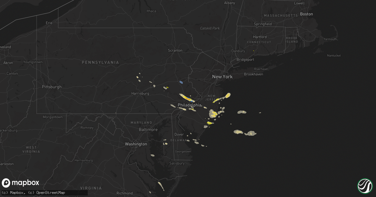
Hail Map on July 21, 2021
Get this storm
July 21 map
$229
one time, instant access
Download today. No call, no setup
Keep the $229
Bought the map and want the full workflow? Apply the entire $229 to a subscription within 7 days. None of it is wasted.
Every map, not just this one
This buys you this map. Subscription and you get every map we run, in the markets you choose from a few cities to whole states to nationwide. Plus real-time alerts the moment a storm fires.
Contact data
Name, contact info, occupancy, even credit band for addresses in the footprint. You go from where it hit to who to call.
Become the source they trust
Unlimited branding weather history reports on demand. You already have the documented answer ready for the property owner, and you are the one who showed up with it.
Property data and RoofTrace estimates
Pull up any address you have got, its value and the exact code rules for that jurisdiction, straight from One Click Code. Then RoofTrace estimates the squares, pitch, and roof value, priced the way you price.
States Impacted by Hail Map on July 21, 2021
Storm reports
Arizona
| Date | Description |
|---|---|
| 07/21/20216:00 PM CDT | Public report and photographs indicate damage to multiple buildings... Including homes and a gas station... And electric vehicle charging stations. Semi blown off inter |
| 07/21/20215:51 AM CDT | At 1051 PM MST, a severe thunderstorm was located over Granite Reef Dam, or near Fountain Hills, moving north at 10 mph. HAZARD...60 mph wind gusts and penny size hail. SOURCE...Radar indicated. IMPACT...Expect damage to roofs, siding, and trees. Locations impacted include... Fountain Hills and Granite Reef Dam. |
| 07/21/20215:25 AM CDT | At 1025 PM MST, a severe thunderstorm was located over Camelback Mountain, or near Paradise Valley, and is nearly stationary. HAZARD...60 mph wind gusts. SOURCE...Radar indicated. IMPACT...Expect damage to roofs, siding, and trees. Locations impacted include... Phoenix, Scottsdale, Tempe, Paradise Valley, Tempe Marketplace, Papago Park, Piestewa Peak Park, Salt River Indian Community, North Mountain Park, Downtown Phoenix, Downtown Scottsdale, Arizona State University, Camelback Mountain and Sky Harbor Airport. |
| 07/21/20211:18 AM CDT | At 618 PM MST, severe thunderstorms were located along a line extending from 13 miles southeast of Yuma Proving Ground to 16 miles south of Kofa Wildlife Refuge, moving north at 10 mph. HAZARD...60 mph wind gusts. SOURCE...Radar indicated. IMPACT...Expect damage to roofs, siding, and trees. Locations impacted include... Yuma Proving Ground and Palm Canyon. |
| 07/20/202111:01 PM CDT | At 401 PM MST, a severe thunderstorm was located over Wickenburg, moving northwest at 10 mph. HAZARD...60 mph wind gusts. SOURCE...Radar indicated. IMPACT...Expect damage to roofs, siding, and trees. Locations impacted include... Wickenburg. |
| 07/20/202110:53 PM CDT | At 353 PM MST, a severe thunderstorm was located near Goodyear, moving northwest at 5 mph. HAZARD...60 mph wind gusts. SOURCE...Radar indicated. IMPACT...Expect damage to roofs, siding, and trees. Locations impacted include... Avondale, Goodyear, Buckeye, Litchfield Park, Perryville, Liberty, Estrella Mountain Park and Estrella Mountain Ranch. |
| 07/20/202110:21 PM CDT | At 320 PM MST, a severe thunderstorm was located over Pima Point At Grand Canyon, or 20 miles west of Desert View at Grand Canyon, moving north at 15 mph. HAZARD...60 mph wind gusts and quarter size hail. SOURCE...Radar indicated. IMPACT...Hail damage to vehicles is expected. Expect wind damage to roofs, siding, and trees. Locations impacted include... Maricopa Point At Grand Canyon, Yaqui Point At Grand Canyon, Hermit's Rest At Grand Canyon, Shoshone Point At Grand Canyon, Pima Point At Grand Canyon, Bright Angel Point, South Rim Visitors Center, Hopi Point At Grand Canyon, North Rim Entrance Station and Grand Canyon Village. |
| 07/20/20219:16 PM CDT | At 215 PM MST, a severe thunderstorm was located 8 miles south of Ajo, moving west at 10 mph. HAZARD...60 mph wind gusts and quarter size hail. SOURCE...Radar indicated. IMPACT...Hail damage to vehicles is expected. Expect wind damage to roofs, siding, and trees. Locations impacted include... Ajo and Organ Pipe Cactus National Monument. This includes Route 85 between mile markers 45 and 52. |
| 07/20/20218:12 PM CDT | At 112 PM MST, a severe thunderstorm was located 19 miles southwest of Avra Valley, or 29 miles northeast of Sells, moving west at 15 mph. HAZARD...60 mph wind gusts and quarter size hail. SOURCE...Radar indicated. IMPACT...Hail damage to vehicles is expected. Expect wind damage to roofs, siding, and trees. Locations impacted include... Queens Well and Sil Nakya. |
| 07/20/20217:24 PM CDT | Several reports of downed power lines across the new kingman-butler area. |
| 07/20/20217:15 PM CDT | Received pictures of damaged fences a trampoline roofs an awning and tree damage from neighborhoods in northern kingman. Lat and lon estimated. Time estimated by radar |
| 07/20/20217:00 PM CDT | Two travel trailers blown over from thunderstorm winds in golden valley. Location estimated. Time estimated from radar. |
California
| Date | Description |
|---|---|
| 07/20/202110:55 PM CDT | 5-6 power poles down. Multiple vehicles stuck. |
Maryland
| Date | Description |
|---|---|
| 07/21/20214:24 PM CDT | Tree down on dogwood court. |
| 07/21/20213:05 PM CDT | Trees down along us route 301 at del rhodes avenue. |
| 07/21/20212:55 PM CDT | Tree down across alternate maryland route 404. |
| 07/21/20212:46 PM CDT | Tree blew down on east run drive. |
| 07/21/20212:05 PM CDT | Tree downed along us-50 in linkwood at maiden forest rd. |
| 07/21/20211:47 PM CDT | Blackwalnut harbor - xbwh weatherflow site. |
| 07/21/20211:20 PM CDT | Tree down on beaver dam road and warren road. |
| 07/21/20211:11 PM CDT | Tree down on southbound md-25 falls road at geist road. |
| 07/21/202112:58 PM CDT | Tree down on wolf den road near sunset trail. |
| 07/21/202112:24 PM CDT | Tree down on northbound i-295 anacostia freeway at i-95/i-495 capital beltway. |
| 07/21/202112:21 PM CDT | Tree down on a residence in the 4800 block of indian heady hgwy |
| 07/21/202112:19 PM CDT | Tree down blocking right 2 lanes of i-295 just north of the i-95 exit. |
| 07/20/202111:25 PM CDT | At 425 PM EDT, a severe thunderstorm was located near Skipton, or 8 miles northwest of Easton, moving southeast at 25 mph. HAZARD...60 mph wind gusts and quarter size hail. SOURCE...Radar indicated. IMPACT...Minor damage to vehicles is possible. Wind damage to roofs, siding, trees, and power lines is possible. Locations impacted include... Easton, Federalsburg, Trappe, Preston, Tanyard, Harmony, Skipton, Copperville, Matthews, Choptank, Wye Mills, Hambleton, Windyhill and Cordova. |
| 07/20/202110:46 PM CDT | At 346 PM EDT, a severe thunderstorm was located over Saint Marys City, moving southeast at 25 mph. HAZARD...60 mph wind gusts and quarter size hail. SOURCE...Radar indicated. IMPACT...Damaging winds will cause some trees and large branches to fall. This could injure those outdoors, as well as damage homes and vehicles. Roadways may become blocked by downed trees. Localized power outages are possible. Unsecured light objects may become projectiles. Locations impacted include... Lexington Park, Piney Point, Tall Timbers, Saint Inigoes Creek, Saint Marys City, Saint George Island, Saint Marys River, Dameron, Valley Lee, Scotland, Point Lookout, Great Mills, Drayden, Saint Inigoes, Park Hall, Callaway and Ridge. |
| 07/20/20219:31 PM CDT | At 231 PM EDT, severe thunderstorms were located along a line extending from 9 miles south of Tilghman Island to Saint Leonard, moving east to southeast at 20 mph. HAZARD...60 mph wind gusts and quarter size hail. SOURCE...Radar indicated. IMPACT...Minor damage to vehicles is possible. Expect wind damage to trees and powerlines. Severe thunderstorms will be near, Taylors Island around 305 PM EDT. University Of Maryland Center For Environmental Studies around 310 PM EDT. Cambridge around 315 PM EDT.Other locations impacted by these severe thunderstorms includeMadison, Brookview, Eldorado, Andrews, Hudson, Crocheron, ChurchCreek, Wingate, Lloyds and Taylors Island. |
| 07/20/20218:46 PM CDT | At 146 PM EDT, a severe thunderstorm was located near Saint Charles, or near Waldorf, moving southeast at 20 mph. HAZARD...60 mph wind gusts and quarter size hail. SOURCE...Radar indicated. IMPACT...Damaging winds will cause some trees and large branches to fall. This could injure those outdoors, as well as damage homes and vehicles. Roadways may become blocked by downed trees. Localized power outages are possible. Unsecured light objects may become projectiles. Locations impacted include... Waldorf, Clinton, Saint Charles, Accokeek, Brandywine, Hughesville, Baden, Aquasco, Bryantown, Eagle Harbor, Northwood and White Plains. |
| 07/20/20218:22 PM CDT | At 122 PM EDT, a severe thunderstorm was located near Greencastle, moving east at 25 mph. HAZARD...60 mph wind gusts and quarter size hail. SOURCE...Radar indicated. IMPACT...Hail damage to vehicles is expected. Expect wind damage to roofs, siding, and trees. Locations impacted include... Waynesboro, Greencastle, Wayne Heights, Rouzerville and State Line.This includes Interstate 81 from mile markers 0 to 4. |
New Jersey
| Date | Description |
|---|---|
| 07/21/20214:36 PM CDT | Wires down on ocean drive in cape may. Time estimated from radar. |
| 07/21/20214:36 PM CDT | Telephone pole snapped in half on w preston ave in wildwood crest. Photo relayed on social media. Time estimated from radar. |
| 07/21/20214:33 PM CDT | Nos site at north cape may measures 58mph gust |
| 07/21/20214:32 PM CDT | Tree down in cape road road in lower township. Time estimated from radar. |
| 07/21/20213:20 PM CDT | A local report indicates 1.00 inch wind near GALLOWAY TWP |
| 07/21/20213:00 PM CDT | Wires down on road in herbertsville... Photo relayed through social media. Time estimated from radar. |
| 07/21/20212:51 PM CDT | Wires down in delanco near border with riverside township/rancocas river. Time estimated from radar. |
| 07/21/20212:50 PM CDT | Large tree limbs down and blocking bridgeboro road near the westfield road intersection in moorestown. Time estimated from radar. |
| 07/21/20212:20 PM CDT | A local report indicates 1.00 inch wind near GLOUCESTER TWP |
| 07/21/20212:20 PM CDT | At laurel springs. |
| 07/21/20212:20 PM CDT | A local report indicates 1.00 inch wind near LAKEHURST |
| 07/21/20212:05 PM CDT | Large branch down on fence in audubon... Photo relayed via social media. Time estimated from radar. |
| 07/21/20211:05 PM CDT | A local report indicates 1.25 inch wind near MANAHAWKIN |
| 07/21/202112:15 PM CDT | A local report indicates 1.00 inch wind near MANAHAWKIN |
| 07/21/202112:05 PM CDT | A local report indicates 1.00 inch wind near STRATFORD |
| 07/21/202112:05 PM CDT | A local report indicates 1.00 inch wind near OCEAN ACRES |
| 07/21/20217:53 AM CDT | At 1253 PM EDT, a severe thunderstorm was located over Barnegat, or 18 miles south of Toms River, moving southeast at 15 mph. HAZARD...60 mph wind gusts and quarter size hail. SOURCE...Radar indicated. IMPACT...Minor damage to vehicles is possible. Wind damage to roofs, siding, trees, and power lines is possible. Locations impacted include... Barnegat, Surf City, Brookville, Warren Grove, Beach Haven West, Manahawkin, Ocean Acres and Waretown.This includes Garden State Parkway between mile markers 61 and 73. |
| 07/21/20217:51 AM CDT | At 1251 PM EDT, a severe thunderstorm was located near Port Republic, or near Atlantic City, moving southeast at 15 mph. HAZARD...60 mph wind gusts and quarter size hail. SOURCE...Radar indicated. IMPACT...Minor damage to vehicles is possible. Wind damage to roofs, siding, trees, and power lines is possible. Locations impacted include... Atlantic City, Pleasantville, Ventnor City, Brigantine, Absecon, Tuckerton, Port Republic, Pomona and Mystic Island.This includes the following highways... Garden State Parkway between mile markers 37 and 43. Atlantic City Expressway between mile markers 0 and 8. |
| 07/21/202112:31 AM CDT | At 531 PM EDT, a severe thunderstorm was located over North Cape May, or near Cape May, moving east at 25 mph. HAZARD...60 mph wind gusts and penny size hail. SOURCE...Radar indicated. IMPACT...Damage to roofs, siding, trees, and power lines is possible. Locations impacted include... Cape May, North Wildwood, Wildwood Crest, Sea Isle City, Avalon, West Cape May, Stone Harbor, Cape May Court House, Scotch Bonnet, Diamond Beach, Green Creek, Rio Grande, North Cape May, Villas, West Wildwood, Erma and Whitesboro-Burleigh.This includes Garden State Parkway between mile markers 0 and 14. |
| 07/20/202110:57 PM CDT | At 357 PM EDT, a severe thunderstorm was located over Paulsboro, or 7 miles southwest of Gloucester City, moving east at 40 mph. HAZARD...60 mph wind gusts and quarter size hail. SOURCE...Radar indicated. IMPACT...Minor damage to vehicles is possible. Wind damage to roofs, siding, trees, and power lines is possible. Locations impacted include... Deptford, Voorhees, West Deptford, Glassboro, Lindenwold, Hammonton, Bellmawr, Woodbury, Pitman, Clayton, Berlin, Tabernacle, Shamong, Paulsboro, Magnolia, Westville, Egg Harbor City, Woodstown, Woodbury Heights and National Park.This includes the following highways... New Jersey Turnpike between exits 2 and 3. Interstate 76 in New Jersey near mile marker 0. Interstate 295 in New Jersey between mile markers 16 and 29. Atlantic City Expressway between mile markers 23 and 44. |
| 07/20/202110:43 PM CDT | At 343 PM EDT, a severe thunderstorm was located over Lakewood, or near Toms River, moving northeast at 25 mph. HAZARD...60 mph wind gusts and quarter size hail. SOURCE...Radar indicated. IMPACT...Minor damage to vehicles is possible. Wind damage to roofs, siding, trees, and power lines is possible. Locations impacted include... Toms River, Long Branch, Asbury Park, Lakewood, Tinton Falls, Manasquan, Point Pleasant Beach, Farmingdale, Mantoloking, Leisure Village, Allenwood, Pleasant Plains, Leisure Village East, Elberon, Ramtown, Brick Township, Collingwood Park, Cedar Glen West, Leisure Village West-Pine Lake Park and Point Pleasant.This includes the following highways... Interstate 195 in New Jersey between mile markers 26 and 34. Garden State Parkway between mile markers 85 and 104. |
| 07/20/20219:52 PM CDT | At 251 PM EDT, a severe thunderstorm was located over Parkesburg, or 12 miles southeast of New Holland, moving east at 30 mph. HAZARD...60 mph wind gusts and quarter size hail. SOURCE...Radar indicated. IMPACT...Minor damage to vehicles is possible. Wind damage to roofs, siding, trees, and power lines is possible. Locations impacted include... West Chester, Chester, Coatesville, Westtown, Downingtown, Parkesburg, Cochranville, Cheyney, Elam, Marshallton, Lima, Chelsea, Radnor Township, Lionville-Marchwood, Gradyville, Paoli, Newtown Square, Chester Township, Lionville and Concordville.This includes the following highways... Interstate 95 in Pennsylvania between mile markers 1 and 4. Interstate 476 in Pennsylvania between mile markers 12 and 13. |
| 07/20/20219:13 PM CDT | At 213 PM EDT, a severe thunderstorm was located over Presidential Lakes, or 22 miles west of Toms River, moving east at 20 mph. HAZARD...60 mph wind gusts and quarter size hail. SOURCE...Radar indicated. IMPACT...Minor damage to vehicles is possible. Wind damage to roofs, siding, trees, and power lines is possible. Locations impacted include... Presidential Lakes Estates, Leisuretowne, Chatsworth, Presidential Lakes, Browns Mills and Country Lake Estates. |
| 07/20/20219:03 PM CDT | At 202 PM EDT, a severe thunderstorm was located over Coffeetown, or near Allentown, moving southeast at 30 mph. HAZARD...60 mph wind gusts and quarter size hail. SOURCE...Radar indicated. IMPACT...Minor damage to vehicles is possible. Wind damage to roofs, siding, trees, and power lines is possible. Locations impacted include... Allentown, Bethlehem, Emmaus, Northampton, Quakertown, Perkasie, Bedminster, Hellertown, Tinicum, Dublin, Ferndale, Riegelsville, Pleasant Valley, Revere, Coffeetown, Ancient Oaks, Lehigh University, Claussville, Ottsville and Pipersville.This includes the following highways... Northeast Extension between mile markers 44 and 63. Interstate 78 in Pennsylvania between mile markers 50 and 72. |
| 07/20/20218:43 PM CDT | At 142 PM EDT, a severe thunderstorm was located near Beach Haven West, or 20 miles northeast of Atlantic City, moving east at 20 mph. HAZARD...60 mph wind gusts and quarter size hail. SOURCE...Radar indicated. IMPACT...Minor damage to vehicles is possible. Wind damage to roofs, siding, trees, and power lines is possible. Locations impacted include... Tuckerton, Surf City, Beach Haven West, Manahawkin and Ocean Acres.This includes Garden State Parkway between mile markers 56 and 66. |
| 07/20/20218:28 PM CDT | At 127 PM EDT, a severe thunderstorm was located near Brigantine, or 7 miles northeast of Atlantic City, moving east at 20 mph. HAZARD...60 mph wind gusts and quarter size hail. SOURCE...Radar indicated. IMPACT...Minor damage to vehicles is possible. Wind damage to roofs, siding, trees, and power lines is possible. Locations impacted include... Atlantic City, Brigantine and Absecon. |
Pennsylvania
| Date | Description |
|---|---|
| 07/21/20212:45 PM CDT | Trees down near vogt recreation center in tacony. Time estimated from radar. |
| 07/21/20212:40 PM CDT | Wires down on carter avenue in chester township. Time estimated from radar. |
| 07/21/20212:40 PM CDT | Trees on wires on stanwood st in rhawnhurst. |
| 07/21/20212:30 PM CDT | A local report indicates 1.00 inch wind near GLENSIDE |
| 07/21/20212:30 PM CDT | A local report indicates 1.00 inch wind near ABINGTON |
| 07/21/20212:30 PM CDT | A local report indicates 1.00 inch wind near JENKINTOWN |
| 07/21/20212:28 PM CDT | Large tree sheared apart in abington township. Photo relayed on social media. Time estimated from radar. |
| 07/21/20212:25 PM CDT | Photo from social media... Hail estimated at quarter size in flourtown. Time estimated from radar. |
| 07/21/20212:20 PM CDT | Trees down near the pennsylvania turnpike. |
| 07/21/20212:15 PM CDT | Numerous photos of large tree limbs down in the in the center square area of blue bell. Time estimated from radar. |
| 07/21/20212:15 PM CDT | Photos relayed on social media... Of hail slightly larger than quarter size. Time estimated from radar. |
| 07/21/20212:11 PM CDT | Hail... To the size of quarters |
| 07/21/20212:10 PM CDT | A local report indicates 1.00 inch wind near PLYMOUTH MEETING |
| 07/21/20212:10 PM CDT | Numerous trees down on wires in whitpain township. Time estimated from radar. |
| 07/21/20212:07 PM CDT | Photo of large tree down in upper gwynedd township. Time estimated from radar. |
| 07/21/20212:05 PM CDT | A local report indicates 1.00 inch wind near EAST NORRITON |
| 07/21/20212:05 PM CDT | Numerous trees down. |
| 07/21/20211:24 PM CDT | Large branch down in spring township... Time estimated from radar. |
| 07/21/20211:20 PM CDT | Wires down south of allentown. Time estimated from radar. |
| 07/21/20211:20 PM CDT | Photo of large tree branches down on wires in west lawn pa. Time estimated by spotter. |
| 07/21/20211:15 PM CDT | Widespread tree damage in west allentown. |
| 07/21/20211:00 PM CDT | A local report indicates 1.00 inch wind near TEMPLE |
| 07/20/202110:48 PM CDT | At 346 PM EDT, a cluster of severe thunderstorms were located primarily over portions of Camden and Burlington counties, moving east at 25mph, HAZARD...60 mph wind gusts and quarter size hail. SOURCE...Radar indicated. IMPACT...Minor damage to vehicles is possible. Wind damage to roofs, siding, trees, and power lines is possible. Locations impacted include... Cherry Hill, Evesham, Mount Laurel, Willingboro, Voorhees, Medford, Lumberton, Florence, Burlington, Bristol, Mount Holly, Riverside, Berlin, Palmyra, Tabernacle, Shamong, Presidential Lakes Estates, Beverly, Chesilhurst and Pemberton.This includes the following highways... New Jersey Turnpike between exits 4 and 6A. Pennsylvania Turnpike between mile markers 355 and 359. Interstate 95 in Pennsylvania between mile markers 35 and 40. Interstate 295 in New Jersey between mile markers 33 and 54. |
| 07/20/202110:16 PM CDT | At 316 PM EDT, a severe thunderstorm was located over Plymouth Meeting, or 10 miles northwest of Philadelphia, moving southeast at 30 mph. This is a very dangerous storm. HAZARD...80 mph wind gusts and half dollar size hail. SOURCE...Radar indicated. IMPACT...Flying debris will be dangerous to those caught without shelter. Mobile homes will be heavily damaged. Expect considerable damage to roofs, windows, and vehicles. Extensive tree damage and power outages are likely. Locations impacted include... Philadelphia, Camden, Gloucester City, Bensalem, Norristown, West Norriton, East Norriton, Bellmawr, Riverside, Conshohocken, Palmyra, Hatboro, Ambler, Jenkintown, Westville, Narberth, Beverly, Rockledge, Brooklawn and Abington.This includes the following highways... Pennsylvania Turnpike between mile markers 329 and 352. Northeast Extension between mile markers 21 and 23. Interstate 95 in Pennsylvania between mile markers 18 and 38. Interstate 76 in Pennsylvania between mile markers 330 and 345, andbetween mile markers 350 and 351. Interstate 76 in New Jersey between mile markers 1 and 3. Interstate 676 in Pennsylvania between mile markers 0 and 1. Interstate 676 in New Jersey between mile markers 0 and 4. Interstate 476 in Pennsylvania between mile markers 15 and 19. |
| 07/20/202110:04 PM CDT | At 303 PM EDT, a severe thunderstorm was located over Ashland, or near Gloucester City, moving east at 30 mph. HAZARD...60 mph wind gusts and quarter size hail. SOURCE...Radar indicated. IMPACT...Minor damage to vehicles is possible. Wind damage to roofs, siding, trees, and power lines is possible. Locations impacted include... Camden, Gloucester City, Cherry Hill, Evesham, Mount Laurel, Deptford, Voorhees, Medford, West Deptford, Lindenwold, Bellmawr, Woodbury, Berlin, Tabernacle, Paulsboro, Magnolia, Westville, Woodbury Heights, National Park and Brooklawn.This includes the following highways... New Jersey Turnpike between exits 3 and 4. Interstate 76 in New Jersey between mile markers 0 and 3. Interstate 295 in New Jersey between mile markers 18 and 39. Interstate 676 in New Jersey between mile markers 0 and 1. Atlantic City Expressway between mile markers 41 and 44. |
| 07/20/20219:48 PM CDT | At 248 PM EDT, a severe thunderstorm was located over Schwenksville, or 20 miles north of West Chester, moving east at 35 mph. HAZARD...60 mph wind gusts and quarter size hail. SOURCE...Radar indicated. IMPACT...Minor damage to vehicles is possible. Wind damage to roofs, siding, trees, and power lines is possible. Locations impacted include... Philadelphia, Bensalem, Norristown, Phoenixville, Lansdale, West Norriton, East Norriton, Conshohocken, Hatboro, Souderton, Ambler, Collegeville, Royersford, Jenkintown, Trappe, Hatfield, Beverly, Rockledge, Abington and Langhorne.This includes the following highways... Pennsylvania Turnpike between mile markers 331 and 355. Northeast Extension between mile markers 21 and 35. Interstate 95 in Pennsylvania between mile markers 27 and 29, andbetween mile markers 32 and 38. Interstate 476 in Pennsylvania between mile markers 18 and 19. |
| 07/20/20219:14 PM CDT | At 214 PM EDT, a group of severe thunderstorms were located over Gilbertsville, or 16 miles east of Reading, moving east at 40 mph. HAZARD...60 mph wind gusts and quarter size hail. SOURCE...Radar indicated. IMPACT...Minor damage to vehicles is possible. Wind damage to roofs, siding, trees, and power lines is possible. Locations impacted include... Reading, Norristown, Pottstown, Phoenixville, Lansdale, West Norriton, East Norriton, Wyomissing, Doylestown, Conshohocken, Hatboro, Souderton, Ambler, Birdsboro, Collegeville, Royersford, Chalfont, Sinking Spring, Laureldale and Trappe.This includes the following highways... Pennsylvania Turnpike between mile markers 323 and 337. Northeast Extension between mile markers 21 and 38. Interstate 76 in Pennsylvania between mile markers 327 and 331. Interstate 476 in Pennsylvania between mile markers 17 and 19. Interstate 176 in Pennsylvania between mile markers 7 and 11. |
| 07/20/20218:27 PM CDT | At 127 PM EDT, a severe thunderstorm was located over Paramount-Long Meadow, or near Greencastle, moving southeast at 25 mph. HAZARD...60 mph wind gusts and quarter size hail. SOURCE...Radar indicated. IMPACT...Damaging winds will cause some trees and large branches to fall. This could injure those outdoors, as well as damage homes and vehicles. Roadways may become blocked by downed trees. Localized power outages are possible. Unsecured light objects may become projectiles. Locations impacted include... Hagerstown, Thurmont, Emmitsburg, Robinwood, Fountainhead-Orchard Hills, Smithsburg, Paramount-Long Meadow, Long Meadow, Maugansville, Cavetown, Leitersburg, Sabillasville, Fort Ritchie, Chewsville, Ringgold, Middleburg, Utica, Rocky Ridge, Highfield and Graceham. |
| 07/20/20218:27 PM CDT | At 126 PM EDT, a severe thunderstorm was located over Fairview Hgts, or 9 miles northwest of Reading, moving southeast at 20 mph. HAZARD...60 mph wind gusts and quarter size hail. SOURCE...Radar indicated. IMPACT...Minor damage to vehicles is possible. Wind damage to roofs, siding, trees, and power lines is possible. Locations impacted include... Reading, Wyomissing, Birdsboro, Fleetwood, Sinking Spring, Laureldale, Womelsdorf, Wernersville, Robesonia, Leesport, Shoemakersville, Bally, Bernville, Bechtelsville, Strausstown, New Morgan, Spring Ridge, Fairview Hgts, Shillington and West Reading.This includes the following highways... Interstate 78 in Pennsylvania near mile marker 8, and between milemarkers 10 and 27. Interstate 176 in Pennsylvania between mile markers 5 and 11. |
| 07/20/20218:26 PM CDT | At 125 PM EDT, a severe thunderstorm was located near Littlestown, or near Parkville, moving southeast at 25 mph. HAZARD...60 mph wind gusts. SOURCE...Radar indicated. IMPACT...Damaging winds will cause some trees and large branches to fall. This could injure those outdoors, as well as damage homes and vehicles. Roadways may become blocked by downed trees. Localized power outages are possible. Unsecured light objects may become projectiles. Locations impacted include... Westminster, Hampstead, Manchester, Upperco, Freeland, Lineboro, Boring, Bentley Springs, Parkton, Hereford, Millers, Greenmount, Butler and Maryland Line. |
Connecticut
| Date | Description |
|---|---|
| 07/21/202112:56 PM CDT | Quarter size hail. |
| 07/20/20218:55 PM CDT | At 155 PM EDT, a severe thunderstorm was located over Hamden, or near New Haven, moving east at 35 mph. HAZARD...60 mph wind gusts and quarter size hail. SOURCE...Radar indicated. IMPACT...Minor hail damage to vehicles is possible. Expect wind damage to trees and power lines. This severe thunderstorm will be near... Branford and North Haven around 210 PM EDT. North Branford around 215 PM EDT. Guilford around 220 PM EDT. Killingworth and North Madison around 230 PM EDT. Clinton around 240 PM EDT. |
District of Columbia
| Date | Description |
|---|---|
| 07/21/202112:19 PM CDT | Tree on car in the 4700 block of 1st street sw. Five people briefly trapped. No injuries. |
| 07/20/20218:14 PM CDT | At 114 PM EDT, a severe thunderstorm was located over Reagan National Airport, moving east at 25 mph. HAZARD...60 mph wind gusts. SOURCE...Radar indicated. IMPACT...Damaging winds will cause some trees and large branches to fall. This could injure those outdoors, as well as damage homes and vehicles. Roadways may become blocked by downed trees. Localized power outages are possible. Unsecured light objects may become projectiles. Locations impacted include... Arlington, Alexandria, Clinton, Fort Washington, Forestville, Huntington, Coral Hills, National Harbor, Upper Marlboro, Reagan National Airport, Crystal City, Nationals Park, Andrews Air Force Base, Rosslyn, Camp Springs, Oxon Hill, Walker Mill, Rosaryville, Friendly and Marlton. |
Massachusetts
| Date | Description |
|---|---|
| 07/21/20217:13 AM CDT | At 1213 AM EDT, severe thunderstorms were located along a line extending from near Barrington to near Newmarket to near Brentwood, moving east at 35 mph. HAZARD...60 mph wind gusts and quarter size hail. SOURCE...Radar indicated. IMPACT...Hail damage to vehicles is expected. Expect wind damage to roofs, siding, and trees. Locations impacted include... Portsmouth, Hampton, Durham, Exeter, Kittery, Dover, Somersworth, Barrington, Brentwood, Greenland, South Berwick, York, Newington, Seabrook, Rye, Stratham, Newmarket, Wells, Eliot and Kingston.This includes the following highways... Interstate 95 between mile markers 1 and 15. Interstate 95 in New Hampshire between mile markers 0 and 16.This also includes... Hampton Beach, York Beach, and Ogunquit Beach. |
| 07/21/20213:30 AM CDT | At 828 PM EDT, a severe thunderstorm was located over Braintree, moving east at 20 mph. HAZARD...60 mph wind gusts and quarter size hail. SOURCE...Radar indicated. IMPACT...Expect wind damage to trees and power lines. Minor hail damage to vehicles is possible. Locations impacted include... Boston, Brockton, Quincy, Weymouth, Braintree, Randolph, Milton, Stoughton, Marshfield, Hingham, Canton, Scituate, Pembroke, Rockland, Abington, Duxbury, Whitman, Hanover, Holbrook and Norwell. |
| 07/20/20217:35 PM CDT | Power lines down on door street at russ street. Time approximate. |
Virginia
| Date | Description |
|---|---|
| 07/21/20216:21 PM CDT | Trees down along coachpoint rd. Time estimated by radar. |
| 07/21/20211:11 PM CDT | Six inch tree branch down on ropp lane near fairbrook lane. |
| 07/21/202112:16 PM CDT | Tree and wires down on e mt ida ave near e randolph ave. |
| 07/21/202112:15 PM CDT | Tree blew down on southbound george washington memorial parkway at slaters lane. |
| 07/21/20212:16 AM CDT | At 716 PM EDT, severe thunderstorms were located along a line extending from White Stone to near Hartfield to near Shacklefords, moving southeast at 20 mph. HAZARD...60 mph wind gusts and quarter size hail. SOURCE...Radar indicated. IMPACT...Minor damage to vehicles is possible. Expect wind damage to trees and powerlines. Severe thunderstorms will be near, Hartfield around 720 PM EDT. Deltaville and Blakes around 735 PM EDT. Gloucester Courthouse around 740 PM EDT. Gwynn around 745 PM EDT. Mathews around 750 PM EDT. Hayes and Mobjack around 755 PM EDT. Gloucester Point, Virginia Institute For Marine Sciences, Bavon, Wicomico and Achilles around 800 PM EDT.Other locations impacted by these severe thunderstorms include Ruff,Beulah, Moon, Laban, Glass, Naxera, Harmony Village, Grafton, Harcumand Cash. |
| 07/21/202112:05 AM CDT | At 505 PM EDT, a severe thunderstorm was located over Port Tobacco River, moving southeast at 30 mph. HAZARD...60 mph wind gusts and quarter size hail. SOURCE...Radar indicated. IMPACT...Damaging winds will cause some trees and large branches to fall. This could injure those outdoors, as well as damage homes and vehicles. Roadways may become blocked by downed trees. Localized power outages are possible. Unsecured light objects may become projectiles. Locations impacted include... La Plata, Popes Creek, Port Tobacco River, Wicomico River, Wicomico, Mechanicsville, Charlotte Hall, Cobb Island, Rock Point, Port Tobacco Village, Bushwood, Clements, Issue, Tompkinsville, Chaptico, Bel Alton, Swan Point, Avenue, Faulkner and Loveville. |
South Dakota
| Date | Description |
|---|---|
| 07/21/20217:47 AM CDT | At 1246 PM MDT, a severe thunderstorm was located 3 miles southeast of Black Elk Peak, or 6 miles northeast of Custer, moving east at 10 mph. HAZARD...60 mph wind gusts and quarter size hail. SOURCE...Radar indicated. IMPACT...Hail damage to vehicles is expected. Expect wind damage to roofs, siding, and trees. This severe thunderstorm will be near... Horse Thief Lake and northern Custer State Park around 1250 PM MDT. Mount Rushmore National Memorial and Legion Lake around 1255 PM MDT. Center Lake and Keystone Wye around 100 PM MDT. Keystone and Black Hills Playhouse around 105 PM MDT.Other locations in the path of this severe thunderstorm include StateGame Lodge and Hayward. |
West Virginia
| Date | Description |
|---|---|
| 07/20/20218:59 PM CDT | At 159 PM EDT, a severe thunderstorm was located over Harpers Ferry, or 8 miles southeast of Shepherdstown, moving southeast at 25 mph. HAZARD...60 mph wind gusts. SOURCE...Radar indicated. IMPACT...Damaging winds will cause some trees and large branches to fall. This could injure those outdoors, as well as damage homes and vehicles. Roadways may become blocked by downed trees. Localized power outages are possible. Unsecured light objects may become projectiles. Locations impacted include... Brunswick, Point Of Rocks, Adamstown, Jefferson, Lovettsville, Buckeystown, Rosemont, Brownsville, Doubs, Lucketts, Knoxville, Petersville, Tuscarora and Taylorstown. |
Montana
| Date | Description |
|---|---|
| 07/21/20216:45 PM CDT | Quarter-sized hail fell for 3-5 minutes. |
| 07/21/20216:28 PM CDT | A local report indicates 1.00 inch wind near 1 NW POTOMAC |
| 07/21/20216:28 PM CDT | Ginm8 raws. Time estimated from radar. |
| 07/21/20216:26 PM CDT | Ekhm8 raws. Time estimated from radar. |
| 07/21/20214:18 AM CDT | At 918 PM MDT, a severe thunderstorm was located 17 miles northwest of Philipsburg, or 19 miles southwest of Drummond, moving northeast at 20 mph. HAZARD...60 mph wind gusts and quarter size hail. SOURCE...Radar indicated. IMPACT...Hail damage to vehicles is expected. Expect wind damage to roofs, siding, and trees. Locations impacted include... Nimrod and Bearmouth. |
| 07/21/20213:54 AM CDT | At 854 PM MDT, a severe thunderstorm was located 15 miles northwest of Augusta, or 26 miles southwest of Choteau, moving northeast at 40 mph. HAZARD...60 mph wind gusts and quarter size hail. SOURCE...Radar indicated. IMPACT...Hail damage to vehicles is expected. Expect wind damage to roofs, siding, and trees. Locations impacted include... Pishkun Reservoir. |
| 07/21/20212:56 AM CDT | At 756 PM MDT, a severe thunderstorm was located 12 miles north of Ovando, or 36 miles north of Drummond, moving northeast at 40 mph. HAZARD...Golf ball size hail and 60 mph wind gusts. SOURCE...Radar indicated. IMPACT...People and animals outdoors will be injured. Expect hail damage to roofs, siding, windows, and vehicles. Expect wind damage to roofs, siding, and trees. This severe thunderstorm will remain over mainly rural areas of west central Lewis and Clark County. |
| 07/21/20212:30 AM CDT | At 729 PM MDT, a severe thunderstorm was located near Ovando, or 19 miles north of Drummond, moving northeast at 30 mph. HAZARD...60 mph wind gusts and quarter size hail. SOURCE...Radar indicated. IMPACT...Hail damage to vehicles is expected. Expect wind damage to roofs, siding, and trees. Locations impacted include... Ovando. |
| 07/21/20211:54 AM CDT | At 654 PM MDT, a severe thunderstorm was located 17 miles northwest of Drummond, moving northeast at 45 mph. HAZARD...60 mph wind gusts and quarter size hail. SOURCE...Radar indicated. IMPACT...Hail damage to vehicles is expected. Expect wind damage to roofs, siding, and trees. Locations impacted include... Ovando, Garnet, Nimrod, Greenough and Clearwater. |
| 07/21/20211:01 AM CDT | At 601 PM MDT, a severe thunderstorm was located near Seeley Lake, or 37 miles north of Drummond, moving northeast at 20 mph. HAZARD...60 mph wind gusts and quarter size hail. SOURCE...Radar indicated. IMPACT...Hail damage to vehicles is expected. Expect wind damage to roofs, siding, and trees. Locations impacted include... Seeley Lake. |
| 07/21/202112:36 AM CDT | At 536 PM MDT, a severe thunderstorm was located 14 miles south of Seeley Lake, or 24 miles east of Missoula, moving northeast at 20 mph near Highway 200. HAZARD...60 mph wind gusts and quarter size hail. SOURCE...Radar indicated. IMPACT...Hail damage to vehicles is expected. Expect wind damage to roofs, siding, and trees. Locations impacted include... Greenough and Clearwater. |
| 07/21/202112:29 AM CDT | At 528 PM MDT, a severe thunderstorm was located near Lothair, or 13 miles southwest of Chester, moving east at 25 mph. HAZARD...60 mph wind gusts and quarter size hail. Severe wind gusts may occur well away from the heaviest part of the storm. SOURCE...Radar indicated. IMPACT...Hail damage to vehicles is expected. Expect wind damage to roofs, siding, and trees. Locations impacted include... Chester, Joplin, Lothair, Tiber Dam and Galata. |
| 07/21/202112:12 AM CDT | At 512 PM MDT, a severe thunderstorm was located 7 miles east of Bonner-West Riverside, or 14 miles east of Missoula, moving northeast at 20 mph. HAZARD...60 mph wind gusts and quarter size hail. SOURCE...Radar indicated. IMPACT...Hail damage to vehicles is expected. Expect wind damage to roofs, siding, and trees. Locations impacted include... Twin Creeks and Clinton. |
| 07/20/202111:45 PM CDT | At 444 PM MDT, a severe thunderstorm was located 10 miles south of Valier, or 11 miles west of Conrad, moving northeast at 35 mph. A second severe thunderstorm was located east of Ledger, also moving northeast at 35 mph. HAZARD...70 mph wind gusts and quarter size hail. SOURCE...Radar indicated. IMPACT...Hail damage to vehicles is expected. Expect considerable tree damage. Wind damage is also likely to mobile homes, roofs, and outbuildings. Locations impacted include... Conrad, Valier, Lothair, Devon, Galata and Ledger. |
| 07/20/202111:07 PM CDT | At 407 PM MDT, a severe thunderstorm was located 22 miles northwest of Choteau, moving northeast at 30 mph. HAZARD...70 mph wind gusts and quarter size hail. SOURCE...Radar indicated. IMPACT...Hail damage to vehicles is expected. Expect considerable tree damage. Wind damage is also likely to mobile homes, roofs, and outbuildings. Locations impacted include... Pendroy. |
| 07/20/202110:53 PM CDT | Asos station khvr havre airport. |
| 07/20/202110:50 PM CDT | At 350 PM MDT, a severe thunderstorm was located 8 miles west of Conrad, moving northeast at 25 mph. HAZARD...60 mph wind gusts and quarter size hail. SOURCE...Radar indicated. IMPACT...Hail damage to vehicles is expected. Expect wind damage to roofs, siding, and trees. Locations impacted include... Conrad and Ledger. |
| 07/20/202110:16 PM CDT | At 315 PM MDT, a severe thunderstorm was located 23 miles northeast of North Browning, or 26 miles northwest of Cut Bank, moving northeast at 35 mph. HAZARD...60 mph wind gusts and quarter size hail. SOURCE...Radar indicated. IMPACT...Hail damage to vehicles is expected. Expect wind damage to roofs, siding, and trees. This severe thunderstorm will remain over mainly rural areas of northeastern Glacier County. |
| 07/20/202110:00 PM CDT | Co-op observer reports 1inch hail. |
| 07/20/20219:56 PM CDT | At 255 PM MDT, a severe thunderstorm was located 15 miles north of North Browning, or 33 miles west of Cut Bank, moving northeast at 25 mph. HAZARD...60 mph wind gusts and half dollar size hail. SOURCE...Radar indicated. IMPACT...Hail damage to vehicles is expected. Expect wind damage to roofs, siding, and trees. This severe thunderstorm will remain over mainly rural areas of northeastern Glacier County. |
| 07/20/20219:27 PM CDT | Forest service fire tower staff reports 1 inch hail. Time estimated from radar. |
| 07/20/20218:45 PM CDT | Golf ball sized hail reported at the monture campground. Lasted for about 5 minutes. |
| 07/20/20218:19 PM CDT | Reported on the anderson hill fire. |
| 07/20/20217:07 PM CDT | Hailed for 20-30 minutes... Max size of 1 inch. Gusty winds around 40mph... Heavy rain. |
Georgia
| Date | Description |
|---|---|
| 07/20/202110:06 PM CDT | At 306 PM EDT, a severe thunderstorm was located over Lakeland, moving northeast at 25 mph. HAZARD...60 mph wind gusts. SOURCE...Radar indicated. IMPACT...Expect damage to roofs, siding, and trees. Locations impacted include... Lakeland, Ray City, Meigs, Courthouse, Greenwood, Allenville, Hansell, Stockton and Teeterville. |
Maine
| Date | Description |
|---|---|
| 07/21/202112:26 AM CDT | At 526 PM EDT, a severe thunderstorm was located 10 miles south of Palermo, or 16 miles east of Gardiner, moving southeast at 20 mph. HAZARD...60 mph wind gusts and quarter size hail. SOURCE...Radar indicated. IMPACT...Hail damage to vehicles is expected. Expect wind damage to roofs, siding, and trees. Locations impacted include... Rockland, Camden, Lincolnville, Liberty, Thomaston, Rockport, Palermo, Islesboro, Jefferson, Hope, Cushing, Appleton, South Thomaston, Washington, Union, Hibberts Gore, Owls Head, Saint George, Somerville and Waldoboro.This also includes... Birch Point Beach State Park. |
| 07/20/202111:18 PM CDT | At 418 PM EDT, a severe thunderstorm was located near Manchester, or 7 miles west of Augusta, moving east at 20 mph. HAZARD...60 mph wind gusts and quarter size hail. SOURCE...Radar indicated. IMPACT...Hail damage to vehicles is expected. Expect wind damage to roofs, siding, and trees. Locations impacted include... Augusta, Gardiner, Turner, China, Litchfield, Belgrade, Farmingdale, Manchester, Hallowell, Winthrop, Greene, Chelsea, Leeds, Wales, Monmouth, Pittston, Wayne, Readfield, West Gardiner and Sidney.This includes the following highways... Interstate 295 between mile markers 49 and 51. Interstate 95 between mile markers 95 and 117. |
| 07/20/202110:57 PM CDT | At 357 PM EDT, a severe thunderstorm was located near Belgrade, or near Oakland, moving east at 25 mph. HAZARD...60 mph wind gusts and quarter size hail. SOURCE...Radar indicated. IMPACT...Hail damage to vehicles is expected. Expect wind damage to roofs, siding, and trees. Locations impacted include... Waterville, Oakland, Thorndike, China, Belgrade, Liberty, Palermo, Unity, Knox, Benton, Albion, Freedom, Winslow, Vassalboro, Hibberts Gore, Sidney, Rome, Somerville and Montville.This includes Interstate 95 between mile markers 118 and 130. |
Texas
| Date | Description |
|---|---|
| 07/20/20218:39 PM CDT | At 138 PM CDT, a severe thunderstorm was located over southwestern Friendswood, moving west at 10 mph. HAZARD...60 mph wind gusts and nickel size hail. SOURCE...Radar indicated. IMPACT...Expect damage to roofs, siding, and trees. Locations impacted include... Pearland, southwestern League City, Friendswood, Alvin, Santa Fe, Webster, Manvel, Greater Hobby Area, southwestern South Belt / Ellington, southwestern Clear Lake, Brookside Village, Iowa Colony, Hillcrest and Minnetex. |
Delaware
| Date | Description |
|---|---|
| 07/20/202111:50 PM CDT | At 450 PM EDT, a severe thunderstorm was located over Milford, or 15 miles north of Georgetown, moving east at 20 mph. HAZARD...60 mph wind gusts and quarter size hail. SOURCE...Radar indicated. IMPACT...Minor damage to vehicles is possible. Wind damage to roofs, siding, trees, and power lines is possible. Locations impacted include... Milford, Ellendale, Big Stone Beach, Frederica and Houston. |
| 07/20/202111:16 PM CDT | At 416 PM EDT, a severe thunderstorm was located over Centerville, moving east at 25 mph. HAZARD...60 mph wind gusts and quarter size hail. SOURCE...Radar indicated. IMPACT...Minor damage to vehicles is possible. Wind damage to roofs, siding, trees, and power lines is possible. Locations impacted include... Centerville, Centreville, Greensboro, Oakland, Ridgely, Goldsboro, Starr, Jumptown, Carville, Hope, Henderson, Marydel and Templeville. |
| 07/20/202110:49 PM CDT | At 349 PM EDT, a severe thunderstorm was located over Cecilton, or 7 miles west of Middletown, moving east at 20 mph. HAZARD...60 mph wind gusts and quarter size hail. SOURCE...Radar indicated. IMPACT...Damaging winds will cause some trees and large branches to fall. This could injure those outdoors, as well as damage homes and vehicles. Roadways may become blocked by downed trees. Localized power outages are possible. Unsecured light objects may become projectiles. Locations impacted include... Cecilton and Warwick. |
| 07/20/202110:27 PM CDT | At 326 PM EDT, a severe thunderstorm was located over Concordville, or near West Chester, moving east at 40 mph. HAZARD...60 mph wind gusts and quarter size hail. SOURCE...Radar indicated. IMPACT...Minor damage to vehicles is possible. Wind damage to roofs, siding, trees, and power lines is possible. Locations impacted include... Philadelphia, Camden, West Chester, Gloucester City, Chester, Deptford, West Deptford, Glassboro, Bellmawr, Yeadon, Westtown, Woodbury, Pitman, Clayton, Folcroft, Swarthmore, Paulsboro, Magnolia, Westville and Woodbury Heights.This includes the following highways... New Jersey Turnpike between exits 2 and 3. Interstate 95 in Pennsylvania between mile markers 0 and 20. Interstate 95 in Delaware between mile markers 18 and 23. Interstate 76 in Pennsylvania between mile markers 345 and 351. Interstate 76 in New Jersey between mile markers 0 and 3. Interstate 295 in New Jersey between mile markers 9 and 30. Interstate 676 in New Jersey between mile markers 0 and 3. Interstate 476 in Pennsylvania between mile markers 0 and 7. |
Colorado
| Date | Description |
|---|---|
| 07/20/202110:44 PM CDT | At 344 PM MDT, a severe thunderstorm was located 12 miles northeast of Crestone Peak, or 17 miles west of Junkins Burn Scar, and is nearly stationary. HAZARD...Half dollar size hail. SOURCE...Radar indicated. IMPACT...Damage to vehicles is expected. Locations impacted include... Silver Cliff, Westcliffe and Rosita. |
Utah
| Date | Description |
|---|---|
| 07/20/20218:55 PM CDT | Wendover port of entry thunderstorm wind gust to 64 mph. |
Cities Impacted by Hail Map on July 21, 2021
- Coatesville, PA
- Kennett Square, PA
- West Chester, PA
- Philadelphia, PA
- Roscoe, MT
- Wickenburg, AZ
- Morristown, AZ
- Ovando, MT
- Antonito, CO
- La Jara, CO
- Florissant, CO
- Helmville, MT
- Drummond, MT
- Pendroy, MT
- Choteau, MT
- Fishtail, MT
- Scottsdale, AZ
- Brick, NJ
- Manchester Township, NJ
- Jackson, NJ
- Lakehurst, NJ
- Lakewood, NJ
- Toms River, NJ
- Howell, NJ
- Dulce, NM
- Manahawkin, NJ
- Westcliffe, CO
- Norristown, PA
- Blue Bell, PA
- Oreland, PA
- Plymouth Meeting, PA
- Fort Washington, PA
- Lafayette Hill, PA
- Flourtown, PA
- Collegeville, PA
- Glenside, PA
- Wyncote, PA
- Beach Haven, NJ
- Jenkintown, PA
- Elkins Park, PA
- Cape May, NJ
- Villas, NJ
- Rio Grande, NJ
- Clinton, MT
- Rapid City, SD
- Chatsworth, NJ
- Vincentown, NJ
- Goodyear, AZ
- Seeley Lake, MT
- Fort Pierre, SD
- Custer, SD
- Edgemont, SD
- Machipongo, VA
- Selinsgrove, PA
- Vallecitos, NM
- Winslow, AZ
- Bonner, MT
- Fountain Hills, AZ
- Mount Pleasant Mills, PA
- Ledger, MT
- Haddonfield, NJ
- Oaklyn, NJ
- Haddon Heights, NJ
- Audubon, NJ
- Collingswood, NJ
- Barrington, NJ
- Chadron, NE
- Ash Fork, AZ
- Chester, MT
- Barnegat, NJ
- Augusta, MT
- Wellton, AZ
- Tacna, AZ
- Gibbstown, NJ
- Swedesboro, NJ
- Bridgeport, NJ
- Garnet Valley, PA
- Chester, PA
- Crum Lynne, PA
- Glen Mills, PA
- Marcus Hook, PA
- Aston, PA
- Brookhaven, PA
- Media, PA
- Heber, AZ
- Browning, MT
- Keystone, SD
- Hermosa, SD
- Conrad, MT
- Dalmatia, PA
- Millersburg, PA
- Mesa, AZ
- Centreville, MD
- Fort Mcdowell, AZ
- Prescott, AZ
- Dewey, AZ
- Port Trevorton, PA
- Liverpool, PA
- Skippack, PA
- Royersford, PA
- Riverside, NJ
- Schwenksville, PA
- Riverton, NJ
- Huntingdon Valley, PA
- Cheltenham, PA
- Lansdale, PA
- Harleysville, PA
- Abington, PA
- Ambler, PA
- Bensalem, PA
- Waretown, NJ
- West Creek, NJ
- Tuckerton, NJ
- Atlantic City, NJ
- Cape May Point, NJ
- Center, CO
- Gallina, NM
- Absecon, NJ
- Tonopah, AZ
- Egg Harbor City, NJ
- Williams, AZ
- Easton, MD
- Queen Anne, MD
- Cordova, MD
- Lincoln, MT
- Lawnside, NJ
- Magnolia, NJ
- Woodbury, NJ
- Stratford, NJ
- Blackwood, NJ
- Glendora, NJ
- Runnemede, NJ
- Thorofare, NJ
- Westville, NJ
- Woodbury Heights, NJ
- Clementon, NJ
- Berlin, NJ
- Somerdale, NJ
- Bouse, AZ
- Payson, AZ
- Herndon, PA
- Shelby, MT
- Galata, MT
- Red River, NM
- Pine Grove, PA
- Tower City, PA
- Greencastle, PA
- Northfield, NJ
- Linwood, NJ
- Egg Harbor Township, NJ
- Somers Point, NJ
- Lindrith, NM
- Phoenix, AZ
- Seligman, AZ
- Fredericksburg, PA
- Lebanon, PA
- Bethel, PA
- Myerstown, PA
- Murdo, SD
- Hay Springs, NE
- Jemez Springs, NM
- Warminster, PA
- Horsham, PA
- Hatboro, PA
- Grand Canyon, AZ
- Gloucester, VA
- Saluda, VA
- Kirkland, AZ
- Denton, MD
- Cape Charles, VA
- Reedville, VA
- Barnegat Light, NJ
- Seaside Park, NJ
- Brackettville, TX
- Chadds Ford, PA
- Salome, AZ
- Sea Girt, NJ
- Manasquan, NJ
- Brielle, NJ
- Reading, PA
- Rio Grande City, TX
- Leesport, PA
- Mohrsville, PA
- Bernville, PA
- Temple, PA
- North Haven, CT
- Hamden, CT
- Center Valley, PA
- Bethlehem, PA
- Coopersburg, PA
- Emmaus, PA
- Allentown, PA
- Dresher, PA