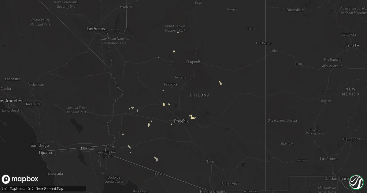
Hail Map in Arizona on July 21, 2021
Get this storm
July 21 map
$229
one time, instant access
Download today. No call, no setup
Keep the $229
Bought the map and want the full workflow? Apply the entire $229 to a subscription within 7 days. None of it is wasted.
Every map, not just this one
This buys you this map. Subscription and you get every map we run, in the markets you choose from a few cities to whole states to nationwide. Plus real-time alerts the moment a storm fires.
Contact data
Name, contact info, occupancy, even credit band for addresses in the footprint. You go from where it hit to who to call.
Become the source they trust
Unlimited branding weather history reports on demand. You already have the documented answer ready for the property owner, and you are the one who showed up with it.
Property data and RoofTrace estimates
Pull up any address you have got, its value and the exact code rules for that jurisdiction, straight from One Click Code. Then RoofTrace estimates the squares, pitch, and roof value, priced the way you price.
Storm reports in Arizona
Arizona
| Date | Description |
|---|---|
| 07/21/20216:00 PM CDT | Public report and photographs indicate damage to multiple buildings... Including homes and a gas station... And electric vehicle charging stations. Semi blown off inter |
| 07/21/20215:51 AM CDT | At 1051 PM MST, a severe thunderstorm was located over Granite Reef Dam, or near Fountain Hills, moving north at 10 mph. HAZARD...60 mph wind gusts and penny size hail. SOURCE...Radar indicated. IMPACT...Expect damage to roofs, siding, and trees. Locations impacted include... Fountain Hills and Granite Reef Dam. |
| 07/21/20215:25 AM CDT | At 1025 PM MST, a severe thunderstorm was located over Camelback Mountain, or near Paradise Valley, and is nearly stationary. HAZARD...60 mph wind gusts. SOURCE...Radar indicated. IMPACT...Expect damage to roofs, siding, and trees. Locations impacted include... Phoenix, Scottsdale, Tempe, Paradise Valley, Tempe Marketplace, Papago Park, Piestewa Peak Park, Salt River Indian Community, North Mountain Park, Downtown Phoenix, Downtown Scottsdale, Arizona State University, Camelback Mountain and Sky Harbor Airport. |
| 07/21/20211:18 AM CDT | At 618 PM MST, severe thunderstorms were located along a line extending from 13 miles southeast of Yuma Proving Ground to 16 miles south of Kofa Wildlife Refuge, moving north at 10 mph. HAZARD...60 mph wind gusts. SOURCE...Radar indicated. IMPACT...Expect damage to roofs, siding, and trees. Locations impacted include... Yuma Proving Ground and Palm Canyon. |
| 07/20/202111:01 PM CDT | At 401 PM MST, a severe thunderstorm was located over Wickenburg, moving northwest at 10 mph. HAZARD...60 mph wind gusts. SOURCE...Radar indicated. IMPACT...Expect damage to roofs, siding, and trees. Locations impacted include... Wickenburg. |
| 07/20/202110:53 PM CDT | At 353 PM MST, a severe thunderstorm was located near Goodyear, moving northwest at 5 mph. HAZARD...60 mph wind gusts. SOURCE...Radar indicated. IMPACT...Expect damage to roofs, siding, and trees. Locations impacted include... Avondale, Goodyear, Buckeye, Litchfield Park, Perryville, Liberty, Estrella Mountain Park and Estrella Mountain Ranch. |
| 07/20/202110:21 PM CDT | At 320 PM MST, a severe thunderstorm was located over Pima Point At Grand Canyon, or 20 miles west of Desert View at Grand Canyon, moving north at 15 mph. HAZARD...60 mph wind gusts and quarter size hail. SOURCE...Radar indicated. IMPACT...Hail damage to vehicles is expected. Expect wind damage to roofs, siding, and trees. Locations impacted include... Maricopa Point At Grand Canyon, Yaqui Point At Grand Canyon, Hermit's Rest At Grand Canyon, Shoshone Point At Grand Canyon, Pima Point At Grand Canyon, Bright Angel Point, South Rim Visitors Center, Hopi Point At Grand Canyon, North Rim Entrance Station and Grand Canyon Village. |
| 07/20/20219:16 PM CDT | At 215 PM MST, a severe thunderstorm was located 8 miles south of Ajo, moving west at 10 mph. HAZARD...60 mph wind gusts and quarter size hail. SOURCE...Radar indicated. IMPACT...Hail damage to vehicles is expected. Expect wind damage to roofs, siding, and trees. Locations impacted include... Ajo and Organ Pipe Cactus National Monument. This includes Route 85 between mile markers 45 and 52. |
| 07/20/20218:12 PM CDT | At 112 PM MST, a severe thunderstorm was located 19 miles southwest of Avra Valley, or 29 miles northeast of Sells, moving west at 15 mph. HAZARD...60 mph wind gusts and quarter size hail. SOURCE...Radar indicated. IMPACT...Hail damage to vehicles is expected. Expect wind damage to roofs, siding, and trees. Locations impacted include... Queens Well and Sil Nakya. |
| 07/20/20217:24 PM CDT | Several reports of downed power lines across the new kingman-butler area. |
| 07/20/20217:15 PM CDT | Received pictures of damaged fences a trampoline roofs an awning and tree damage from neighborhoods in northern kingman. Lat and lon estimated. Time estimated by radar |
| 07/20/20217:00 PM CDT | Two travel trailers blown over from thunderstorm winds in golden valley. Location estimated. Time estimated from radar. |
All States Impacted by Hail Map on July 21, 2021
Cities Impacted by Hail Map on July 21, 2021
- Coatesville, PA
- Kennett Square, PA
- West Chester, PA
- Philadelphia, PA
- Roscoe, MT
- Wickenburg, AZ
- Morristown, AZ
- Ovando, MT
- Antonito, CO
- La Jara, CO
- Florissant, CO
- Helmville, MT
- Drummond, MT
- Pendroy, MT
- Choteau, MT
- Fishtail, MT
- Scottsdale, AZ
- Brick, NJ
- Manchester Township, NJ
- Jackson, NJ
- Lakehurst, NJ
- Lakewood, NJ
- Toms River, NJ
- Howell, NJ
- Dulce, NM
- Manahawkin, NJ
- Westcliffe, CO
- Norristown, PA
- Blue Bell, PA
- Oreland, PA
- Plymouth Meeting, PA
- Fort Washington, PA
- Lafayette Hill, PA
- Flourtown, PA
- Collegeville, PA
- Glenside, PA
- Wyncote, PA
- Beach Haven, NJ
- Jenkintown, PA
- Elkins Park, PA
- Cape May, NJ
- Villas, NJ
- Rio Grande, NJ
- Clinton, MT
- Rapid City, SD
- Chatsworth, NJ
- Vincentown, NJ
- Goodyear, AZ
- Seeley Lake, MT
- Fort Pierre, SD
- Custer, SD
- Edgemont, SD
- Machipongo, VA
- Selinsgrove, PA
- Vallecitos, NM
- Winslow, AZ
- Bonner, MT
- Fountain Hills, AZ
- Mount Pleasant Mills, PA
- Ledger, MT
- Haddonfield, NJ
- Oaklyn, NJ
- Haddon Heights, NJ
- Audubon, NJ
- Collingswood, NJ
- Barrington, NJ
- Chadron, NE
- Ash Fork, AZ
- Chester, MT
- Barnegat, NJ
- Augusta, MT
- Wellton, AZ
- Tacna, AZ
- Gibbstown, NJ
- Swedesboro, NJ
- Bridgeport, NJ
- Garnet Valley, PA
- Chester, PA
- Crum Lynne, PA
- Glen Mills, PA
- Marcus Hook, PA
- Aston, PA
- Brookhaven, PA
- Media, PA
- Heber, AZ
- Browning, MT
- Keystone, SD
- Hermosa, SD
- Conrad, MT
- Dalmatia, PA
- Millersburg, PA
- Mesa, AZ
- Centreville, MD
- Fort Mcdowell, AZ
- Prescott, AZ
- Dewey, AZ
- Port Trevorton, PA
- Liverpool, PA
- Skippack, PA
- Royersford, PA
- Riverside, NJ
- Schwenksville, PA
- Riverton, NJ
- Huntingdon Valley, PA
- Cheltenham, PA
- Lansdale, PA
- Harleysville, PA
- Abington, PA
- Ambler, PA
- Bensalem, PA
- Waretown, NJ
- West Creek, NJ
- Tuckerton, NJ
- Atlantic City, NJ
- Cape May Point, NJ
- Center, CO
- Gallina, NM
- Absecon, NJ
- Tonopah, AZ
- Egg Harbor City, NJ
- Williams, AZ
- Easton, MD
- Queen Anne, MD
- Cordova, MD
- Lincoln, MT
- Lawnside, NJ
- Magnolia, NJ
- Woodbury, NJ
- Stratford, NJ
- Blackwood, NJ
- Glendora, NJ
- Runnemede, NJ
- Thorofare, NJ
- Westville, NJ
- Woodbury Heights, NJ
- Clementon, NJ
- Berlin, NJ
- Somerdale, NJ
- Bouse, AZ
- Payson, AZ
- Herndon, PA
- Shelby, MT
- Galata, MT
- Red River, NM
- Pine Grove, PA
- Tower City, PA
- Greencastle, PA
- Northfield, NJ
- Linwood, NJ
- Egg Harbor Township, NJ
- Somers Point, NJ
- Lindrith, NM
- Phoenix, AZ
- Seligman, AZ
- Fredericksburg, PA
- Lebanon, PA
- Bethel, PA
- Myerstown, PA
- Murdo, SD
- Hay Springs, NE
- Jemez Springs, NM
- Warminster, PA
- Horsham, PA
- Hatboro, PA
- Grand Canyon, AZ
- Gloucester, VA
- Saluda, VA
- Kirkland, AZ
- Denton, MD
- Cape Charles, VA
- Reedville, VA
- Barnegat Light, NJ
- Seaside Park, NJ
- Brackettville, TX
- Chadds Ford, PA
- Salome, AZ
- Sea Girt, NJ
- Manasquan, NJ
- Brielle, NJ
- Reading, PA
- Rio Grande City, TX
- Leesport, PA
- Mohrsville, PA
- Bernville, PA
- Temple, PA
- North Haven, CT
- Hamden, CT
- Center Valley, PA
- Bethlehem, PA
- Coopersburg, PA
- Emmaus, PA
- Allentown, PA
- Dresher, PA


