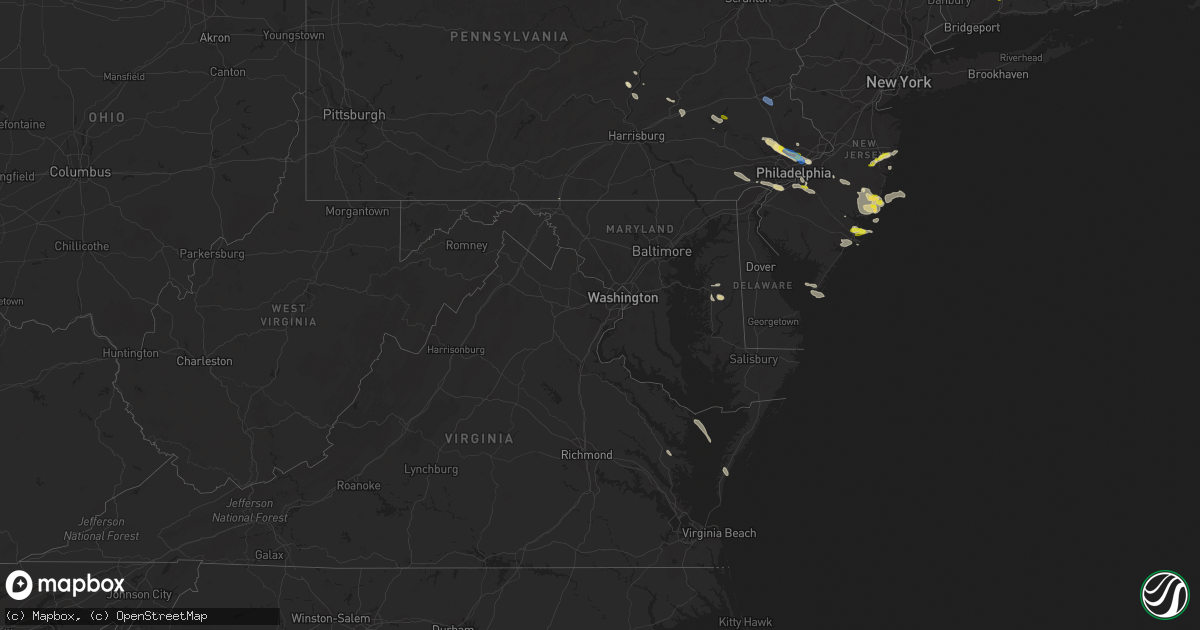
Hail Map in Maryland on July 21, 2021
Get this storm
July 21 map
$229
one time, instant access
Download today. No call, no setup
Keep the $229
Bought the map and want the full workflow? Apply the entire $229 to a subscription within 7 days. None of it is wasted.
Every map, not just this one
This buys you this map. Subscription and you get every map we run, in the markets you choose from a few cities to whole states to nationwide. Plus real-time alerts the moment a storm fires.
Contact data
Name, contact info, occupancy, even credit band for addresses in the footprint. You go from where it hit to who to call.
Become the source they trust
Unlimited branding weather history reports on demand. You already have the documented answer ready for the property owner, and you are the one who showed up with it.
Property data and RoofTrace estimates
Pull up any address you have got, its value and the exact code rules for that jurisdiction, straight from One Click Code. Then RoofTrace estimates the squares, pitch, and roof value, priced the way you price.
Storm reports in Maryland
Maryland
| Date | Description |
|---|---|
| 07/21/20214:24 PM CDT | Tree down on dogwood court. |
| 07/21/20213:05 PM CDT | Trees down along us route 301 at del rhodes avenue. |
| 07/21/20212:55 PM CDT | Tree down across alternate maryland route 404. |
| 07/21/20212:46 PM CDT | Tree blew down on east run drive. |
| 07/21/20212:05 PM CDT | Tree downed along us-50 in linkwood at maiden forest rd. |
| 07/21/20211:47 PM CDT | Blackwalnut harbor - xbwh weatherflow site. |
| 07/21/20211:20 PM CDT | Tree down on beaver dam road and warren road. |
| 07/21/20211:11 PM CDT | Tree down on southbound md-25 falls road at geist road. |
| 07/21/202112:58 PM CDT | Tree down on wolf den road near sunset trail. |
| 07/21/202112:24 PM CDT | Tree down on northbound i-295 anacostia freeway at i-95/i-495 capital beltway. |
| 07/21/202112:21 PM CDT | Tree down on a residence in the 4800 block of indian heady hgwy |
| 07/21/202112:19 PM CDT | Tree down blocking right 2 lanes of i-295 just north of the i-95 exit. |
| 07/20/202111:25 PM CDT | At 425 PM EDT, a severe thunderstorm was located near Skipton, or 8 miles northwest of Easton, moving southeast at 25 mph. HAZARD...60 mph wind gusts and quarter size hail. SOURCE...Radar indicated. IMPACT...Minor damage to vehicles is possible. Wind damage to roofs, siding, trees, and power lines is possible. Locations impacted include... Easton, Federalsburg, Trappe, Preston, Tanyard, Harmony, Skipton, Copperville, Matthews, Choptank, Wye Mills, Hambleton, Windyhill and Cordova. |
| 07/20/202110:46 PM CDT | At 346 PM EDT, a severe thunderstorm was located over Saint Marys City, moving southeast at 25 mph. HAZARD...60 mph wind gusts and quarter size hail. SOURCE...Radar indicated. IMPACT...Damaging winds will cause some trees and large branches to fall. This could injure those outdoors, as well as damage homes and vehicles. Roadways may become blocked by downed trees. Localized power outages are possible. Unsecured light objects may become projectiles. Locations impacted include... Lexington Park, Piney Point, Tall Timbers, Saint Inigoes Creek, Saint Marys City, Saint George Island, Saint Marys River, Dameron, Valley Lee, Scotland, Point Lookout, Great Mills, Drayden, Saint Inigoes, Park Hall, Callaway and Ridge. |
| 07/20/20219:31 PM CDT | At 231 PM EDT, severe thunderstorms were located along a line extending from 9 miles south of Tilghman Island to Saint Leonard, moving east to southeast at 20 mph. HAZARD...60 mph wind gusts and quarter size hail. SOURCE...Radar indicated. IMPACT...Minor damage to vehicles is possible. Expect wind damage to trees and powerlines. Severe thunderstorms will be near, Taylors Island around 305 PM EDT. University Of Maryland Center For Environmental Studies around 310 PM EDT. Cambridge around 315 PM EDT.Other locations impacted by these severe thunderstorms includeMadison, Brookview, Eldorado, Andrews, Hudson, Crocheron, ChurchCreek, Wingate, Lloyds and Taylors Island. |
| 07/20/20218:46 PM CDT | At 146 PM EDT, a severe thunderstorm was located near Saint Charles, or near Waldorf, moving southeast at 20 mph. HAZARD...60 mph wind gusts and quarter size hail. SOURCE...Radar indicated. IMPACT...Damaging winds will cause some trees and large branches to fall. This could injure those outdoors, as well as damage homes and vehicles. Roadways may become blocked by downed trees. Localized power outages are possible. Unsecured light objects may become projectiles. Locations impacted include... Waldorf, Clinton, Saint Charles, Accokeek, Brandywine, Hughesville, Baden, Aquasco, Bryantown, Eagle Harbor, Northwood and White Plains. |
| 07/20/20218:22 PM CDT | At 122 PM EDT, a severe thunderstorm was located near Greencastle, moving east at 25 mph. HAZARD...60 mph wind gusts and quarter size hail. SOURCE...Radar indicated. IMPACT...Hail damage to vehicles is expected. Expect wind damage to roofs, siding, and trees. Locations impacted include... Waynesboro, Greencastle, Wayne Heights, Rouzerville and State Line.This includes Interstate 81 from mile markers 0 to 4. |
All States Impacted by Hail Map on July 21, 2021
Cities Impacted by Hail Map on July 21, 2021
- Coatesville, PA
- Kennett Square, PA
- West Chester, PA
- Philadelphia, PA
- Roscoe, MT
- Wickenburg, AZ
- Morristown, AZ
- Ovando, MT
- Antonito, CO
- La Jara, CO
- Florissant, CO
- Helmville, MT
- Drummond, MT
- Pendroy, MT
- Choteau, MT
- Fishtail, MT
- Scottsdale, AZ
- Brick, NJ
- Manchester Township, NJ
- Jackson, NJ
- Lakehurst, NJ
- Lakewood, NJ
- Toms River, NJ
- Howell, NJ
- Dulce, NM
- Manahawkin, NJ
- Westcliffe, CO
- Norristown, PA
- Blue Bell, PA
- Oreland, PA
- Plymouth Meeting, PA
- Fort Washington, PA
- Lafayette Hill, PA
- Flourtown, PA
- Collegeville, PA
- Glenside, PA
- Wyncote, PA
- Beach Haven, NJ
- Jenkintown, PA
- Elkins Park, PA
- Cape May, NJ
- Villas, NJ
- Rio Grande, NJ
- Clinton, MT
- Rapid City, SD
- Chatsworth, NJ
- Vincentown, NJ
- Goodyear, AZ
- Seeley Lake, MT
- Fort Pierre, SD
- Custer, SD
- Edgemont, SD
- Machipongo, VA
- Selinsgrove, PA
- Vallecitos, NM
- Winslow, AZ
- Bonner, MT
- Fountain Hills, AZ
- Mount Pleasant Mills, PA
- Ledger, MT
- Haddonfield, NJ
- Oaklyn, NJ
- Haddon Heights, NJ
- Audubon, NJ
- Collingswood, NJ
- Barrington, NJ
- Chadron, NE
- Ash Fork, AZ
- Chester, MT
- Barnegat, NJ
- Augusta, MT
- Wellton, AZ
- Tacna, AZ
- Gibbstown, NJ
- Swedesboro, NJ
- Bridgeport, NJ
- Garnet Valley, PA
- Chester, PA
- Crum Lynne, PA
- Glen Mills, PA
- Marcus Hook, PA
- Aston, PA
- Brookhaven, PA
- Media, PA
- Heber, AZ
- Browning, MT
- Keystone, SD
- Hermosa, SD
- Conrad, MT
- Dalmatia, PA
- Millersburg, PA
- Mesa, AZ
- Centreville, MD
- Fort Mcdowell, AZ
- Prescott, AZ
- Dewey, AZ
- Port Trevorton, PA
- Liverpool, PA
- Skippack, PA
- Royersford, PA
- Riverside, NJ
- Schwenksville, PA
- Riverton, NJ
- Huntingdon Valley, PA
- Cheltenham, PA
- Lansdale, PA
- Harleysville, PA
- Abington, PA
- Ambler, PA
- Bensalem, PA
- Waretown, NJ
- West Creek, NJ
- Tuckerton, NJ
- Atlantic City, NJ
- Cape May Point, NJ
- Center, CO
- Gallina, NM
- Absecon, NJ
- Tonopah, AZ
- Egg Harbor City, NJ
- Williams, AZ
- Easton, MD
- Queen Anne, MD
- Cordova, MD
- Lincoln, MT
- Lawnside, NJ
- Magnolia, NJ
- Woodbury, NJ
- Stratford, NJ
- Blackwood, NJ
- Glendora, NJ
- Runnemede, NJ
- Thorofare, NJ
- Westville, NJ
- Woodbury Heights, NJ
- Clementon, NJ
- Berlin, NJ
- Somerdale, NJ
- Bouse, AZ
- Payson, AZ
- Herndon, PA
- Shelby, MT
- Galata, MT
- Red River, NM
- Pine Grove, PA
- Tower City, PA
- Greencastle, PA
- Northfield, NJ
- Linwood, NJ
- Egg Harbor Township, NJ
- Somers Point, NJ
- Lindrith, NM
- Phoenix, AZ
- Seligman, AZ
- Fredericksburg, PA
- Lebanon, PA
- Bethel, PA
- Myerstown, PA
- Murdo, SD
- Hay Springs, NE
- Jemez Springs, NM
- Warminster, PA
- Horsham, PA
- Hatboro, PA
- Grand Canyon, AZ
- Gloucester, VA
- Saluda, VA
- Kirkland, AZ
- Denton, MD
- Cape Charles, VA
- Reedville, VA
- Barnegat Light, NJ
- Seaside Park, NJ
- Brackettville, TX
- Chadds Ford, PA
- Salome, AZ
- Sea Girt, NJ
- Manasquan, NJ
- Brielle, NJ
- Reading, PA
- Rio Grande City, TX
- Leesport, PA
- Mohrsville, PA
- Bernville, PA
- Temple, PA
- North Haven, CT
- Hamden, CT
- Center Valley, PA
- Bethlehem, PA
- Coopersburg, PA
- Emmaus, PA
- Allentown, PA
- Dresher, PA


