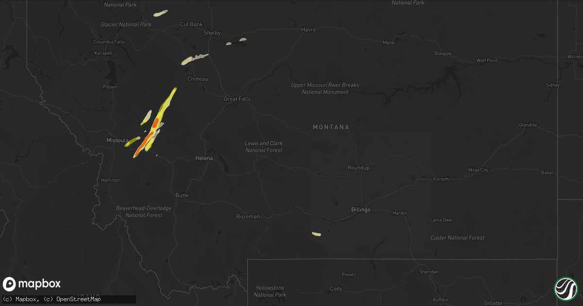
Hail Map in Montana on July 21, 2021
Get this storm
July 21 map
$229
one time, instant access
Download today. No call, no setup
Keep the $229
Bought the map and want the full workflow? Apply the entire $229 to a subscription within 7 days. None of it is wasted.
Every map, not just this one
This buys you this map. Subscription and you get every map we run, in the markets you choose from a few cities to whole states to nationwide. Plus real-time alerts the moment a storm fires.
Contact data
Name, contact info, occupancy, even credit band for addresses in the footprint. You go from where it hit to who to call.
Become the source they trust
Unlimited branding weather history reports on demand. You already have the documented answer ready for the property owner, and you are the one who showed up with it.
Property data and RoofTrace estimates
Pull up any address you have got, its value and the exact code rules for that jurisdiction, straight from One Click Code. Then RoofTrace estimates the squares, pitch, and roof value, priced the way you price.
Storm reports in Montana
Montana
| Date | Description |
|---|---|
| 07/21/20216:45 PM CDT | Quarter-sized hail fell for 3-5 minutes. |
| 07/21/20216:28 PM CDT | Ginm8 raws. Time estimated from radar. |
| 07/21/20216:28 PM CDT | A local report indicates 1.00 inch wind near 1 NW POTOMAC |
| 07/21/20216:26 PM CDT | Ekhm8 raws. Time estimated from radar. |
| 07/21/20214:18 AM CDT | At 918 PM MDT, a severe thunderstorm was located 17 miles northwest of Philipsburg, or 19 miles southwest of Drummond, moving northeast at 20 mph. HAZARD...60 mph wind gusts and quarter size hail. SOURCE...Radar indicated. IMPACT...Hail damage to vehicles is expected. Expect wind damage to roofs, siding, and trees. Locations impacted include... Nimrod and Bearmouth. |
| 07/21/20213:54 AM CDT | At 854 PM MDT, a severe thunderstorm was located 15 miles northwest of Augusta, or 26 miles southwest of Choteau, moving northeast at 40 mph. HAZARD...60 mph wind gusts and quarter size hail. SOURCE...Radar indicated. IMPACT...Hail damage to vehicles is expected. Expect wind damage to roofs, siding, and trees. Locations impacted include... Pishkun Reservoir. |
| 07/21/20212:56 AM CDT | At 756 PM MDT, a severe thunderstorm was located 12 miles north of Ovando, or 36 miles north of Drummond, moving northeast at 40 mph. HAZARD...Golf ball size hail and 60 mph wind gusts. SOURCE...Radar indicated. IMPACT...People and animals outdoors will be injured. Expect hail damage to roofs, siding, windows, and vehicles. Expect wind damage to roofs, siding, and trees. This severe thunderstorm will remain over mainly rural areas of west central Lewis and Clark County. |
| 07/21/20212:30 AM CDT | At 729 PM MDT, a severe thunderstorm was located near Ovando, or 19 miles north of Drummond, moving northeast at 30 mph. HAZARD...60 mph wind gusts and quarter size hail. SOURCE...Radar indicated. IMPACT...Hail damage to vehicles is expected. Expect wind damage to roofs, siding, and trees. Locations impacted include... Ovando. |
| 07/21/20211:54 AM CDT | At 654 PM MDT, a severe thunderstorm was located 17 miles northwest of Drummond, moving northeast at 45 mph. HAZARD...60 mph wind gusts and quarter size hail. SOURCE...Radar indicated. IMPACT...Hail damage to vehicles is expected. Expect wind damage to roofs, siding, and trees. Locations impacted include... Ovando, Garnet, Nimrod, Greenough and Clearwater. |
| 07/21/20211:01 AM CDT | At 601 PM MDT, a severe thunderstorm was located near Seeley Lake, or 37 miles north of Drummond, moving northeast at 20 mph. HAZARD...60 mph wind gusts and quarter size hail. SOURCE...Radar indicated. IMPACT...Hail damage to vehicles is expected. Expect wind damage to roofs, siding, and trees. Locations impacted include... Seeley Lake. |
| 07/21/202112:36 AM CDT | At 536 PM MDT, a severe thunderstorm was located 14 miles south of Seeley Lake, or 24 miles east of Missoula, moving northeast at 20 mph near Highway 200. HAZARD...60 mph wind gusts and quarter size hail. SOURCE...Radar indicated. IMPACT...Hail damage to vehicles is expected. Expect wind damage to roofs, siding, and trees. Locations impacted include... Greenough and Clearwater. |
| 07/21/202112:29 AM CDT | At 528 PM MDT, a severe thunderstorm was located near Lothair, or 13 miles southwest of Chester, moving east at 25 mph. HAZARD...60 mph wind gusts and quarter size hail. Severe wind gusts may occur well away from the heaviest part of the storm. SOURCE...Radar indicated. IMPACT...Hail damage to vehicles is expected. Expect wind damage to roofs, siding, and trees. Locations impacted include... Chester, Joplin, Lothair, Tiber Dam and Galata. |
| 07/21/202112:12 AM CDT | At 512 PM MDT, a severe thunderstorm was located 7 miles east of Bonner-West Riverside, or 14 miles east of Missoula, moving northeast at 20 mph. HAZARD...60 mph wind gusts and quarter size hail. SOURCE...Radar indicated. IMPACT...Hail damage to vehicles is expected. Expect wind damage to roofs, siding, and trees. Locations impacted include... Twin Creeks and Clinton. |
| 07/20/202111:45 PM CDT | At 444 PM MDT, a severe thunderstorm was located 10 miles south of Valier, or 11 miles west of Conrad, moving northeast at 35 mph. A second severe thunderstorm was located east of Ledger, also moving northeast at 35 mph. HAZARD...70 mph wind gusts and quarter size hail. SOURCE...Radar indicated. IMPACT...Hail damage to vehicles is expected. Expect considerable tree damage. Wind damage is also likely to mobile homes, roofs, and outbuildings. Locations impacted include... Conrad, Valier, Lothair, Devon, Galata and Ledger. |
| 07/20/202111:07 PM CDT | At 407 PM MDT, a severe thunderstorm was located 22 miles northwest of Choteau, moving northeast at 30 mph. HAZARD...70 mph wind gusts and quarter size hail. SOURCE...Radar indicated. IMPACT...Hail damage to vehicles is expected. Expect considerable tree damage. Wind damage is also likely to mobile homes, roofs, and outbuildings. Locations impacted include... Pendroy. |
| 07/20/202110:53 PM CDT | Asos station khvr havre airport. |
| 07/20/202110:50 PM CDT | At 350 PM MDT, a severe thunderstorm was located 8 miles west of Conrad, moving northeast at 25 mph. HAZARD...60 mph wind gusts and quarter size hail. SOURCE...Radar indicated. IMPACT...Hail damage to vehicles is expected. Expect wind damage to roofs, siding, and trees. Locations impacted include... Conrad and Ledger. |
| 07/20/202110:16 PM CDT | At 315 PM MDT, a severe thunderstorm was located 23 miles northeast of North Browning, or 26 miles northwest of Cut Bank, moving northeast at 35 mph. HAZARD...60 mph wind gusts and quarter size hail. SOURCE...Radar indicated. IMPACT...Hail damage to vehicles is expected. Expect wind damage to roofs, siding, and trees. This severe thunderstorm will remain over mainly rural areas of northeastern Glacier County. |
| 07/20/202110:00 PM CDT | Co-op observer reports 1inch hail. |
| 07/20/20219:56 PM CDT | At 255 PM MDT, a severe thunderstorm was located 15 miles north of North Browning, or 33 miles west of Cut Bank, moving northeast at 25 mph. HAZARD...60 mph wind gusts and half dollar size hail. SOURCE...Radar indicated. IMPACT...Hail damage to vehicles is expected. Expect wind damage to roofs, siding, and trees. This severe thunderstorm will remain over mainly rural areas of northeastern Glacier County. |
| 07/20/20219:27 PM CDT | Forest service fire tower staff reports 1 inch hail. Time estimated from radar. |
| 07/20/20218:45 PM CDT | Golf ball sized hail reported at the monture campground. Lasted for about 5 minutes. |
| 07/20/20218:19 PM CDT | Reported on the anderson hill fire. |
| 07/20/20217:07 PM CDT | Hailed for 20-30 minutes... Max size of 1 inch. Gusty winds around 40mph... Heavy rain. |
All States Impacted by Hail Map on July 21, 2021
Cities Impacted by Hail Map on July 21, 2021
- Coatesville, PA
- Kennett Square, PA
- West Chester, PA
- Philadelphia, PA
- Roscoe, MT
- Wickenburg, AZ
- Morristown, AZ
- Ovando, MT
- Antonito, CO
- La Jara, CO
- Florissant, CO
- Helmville, MT
- Drummond, MT
- Pendroy, MT
- Choteau, MT
- Fishtail, MT
- Scottsdale, AZ
- Brick, NJ
- Manchester Township, NJ
- Jackson, NJ
- Lakehurst, NJ
- Lakewood, NJ
- Toms River, NJ
- Howell, NJ
- Dulce, NM
- Manahawkin, NJ
- Westcliffe, CO
- Norristown, PA
- Blue Bell, PA
- Oreland, PA
- Plymouth Meeting, PA
- Fort Washington, PA
- Lafayette Hill, PA
- Flourtown, PA
- Collegeville, PA
- Glenside, PA
- Wyncote, PA
- Beach Haven, NJ
- Jenkintown, PA
- Elkins Park, PA
- Cape May, NJ
- Villas, NJ
- Rio Grande, NJ
- Clinton, MT
- Rapid City, SD
- Chatsworth, NJ
- Vincentown, NJ
- Goodyear, AZ
- Seeley Lake, MT
- Fort Pierre, SD
- Custer, SD
- Edgemont, SD
- Machipongo, VA
- Selinsgrove, PA
- Vallecitos, NM
- Winslow, AZ
- Bonner, MT
- Fountain Hills, AZ
- Mount Pleasant Mills, PA
- Ledger, MT
- Haddonfield, NJ
- Oaklyn, NJ
- Haddon Heights, NJ
- Audubon, NJ
- Collingswood, NJ
- Barrington, NJ
- Chadron, NE
- Ash Fork, AZ
- Chester, MT
- Barnegat, NJ
- Augusta, MT
- Wellton, AZ
- Tacna, AZ
- Gibbstown, NJ
- Swedesboro, NJ
- Bridgeport, NJ
- Garnet Valley, PA
- Chester, PA
- Crum Lynne, PA
- Glen Mills, PA
- Marcus Hook, PA
- Aston, PA
- Brookhaven, PA
- Media, PA
- Heber, AZ
- Browning, MT
- Keystone, SD
- Hermosa, SD
- Conrad, MT
- Dalmatia, PA
- Millersburg, PA
- Mesa, AZ
- Centreville, MD
- Fort Mcdowell, AZ
- Prescott, AZ
- Dewey, AZ
- Port Trevorton, PA
- Liverpool, PA
- Skippack, PA
- Royersford, PA
- Riverside, NJ
- Schwenksville, PA
- Riverton, NJ
- Huntingdon Valley, PA
- Cheltenham, PA
- Lansdale, PA
- Harleysville, PA
- Abington, PA
- Ambler, PA
- Bensalem, PA
- Waretown, NJ
- West Creek, NJ
- Tuckerton, NJ
- Atlantic City, NJ
- Cape May Point, NJ
- Center, CO
- Gallina, NM
- Absecon, NJ
- Tonopah, AZ
- Egg Harbor City, NJ
- Williams, AZ
- Easton, MD
- Queen Anne, MD
- Cordova, MD
- Lincoln, MT
- Lawnside, NJ
- Magnolia, NJ
- Woodbury, NJ
- Stratford, NJ
- Blackwood, NJ
- Glendora, NJ
- Runnemede, NJ
- Thorofare, NJ
- Westville, NJ
- Woodbury Heights, NJ
- Clementon, NJ
- Berlin, NJ
- Somerdale, NJ
- Bouse, AZ
- Payson, AZ
- Herndon, PA
- Shelby, MT
- Galata, MT
- Red River, NM
- Pine Grove, PA
- Tower City, PA
- Greencastle, PA
- Northfield, NJ
- Linwood, NJ
- Egg Harbor Township, NJ
- Somers Point, NJ
- Lindrith, NM
- Phoenix, AZ
- Seligman, AZ
- Fredericksburg, PA
- Lebanon, PA
- Bethel, PA
- Myerstown, PA
- Murdo, SD
- Hay Springs, NE
- Jemez Springs, NM
- Warminster, PA
- Horsham, PA
- Hatboro, PA
- Grand Canyon, AZ
- Gloucester, VA
- Saluda, VA
- Kirkland, AZ
- Denton, MD
- Cape Charles, VA
- Reedville, VA
- Barnegat Light, NJ
- Seaside Park, NJ
- Brackettville, TX
- Chadds Ford, PA
- Salome, AZ
- Sea Girt, NJ
- Manasquan, NJ
- Brielle, NJ
- Reading, PA
- Rio Grande City, TX
- Leesport, PA
- Mohrsville, PA
- Bernville, PA
- Temple, PA
- North Haven, CT
- Hamden, CT
- Center Valley, PA
- Bethlehem, PA
- Coopersburg, PA
- Emmaus, PA
- Allentown, PA
- Dresher, PA


