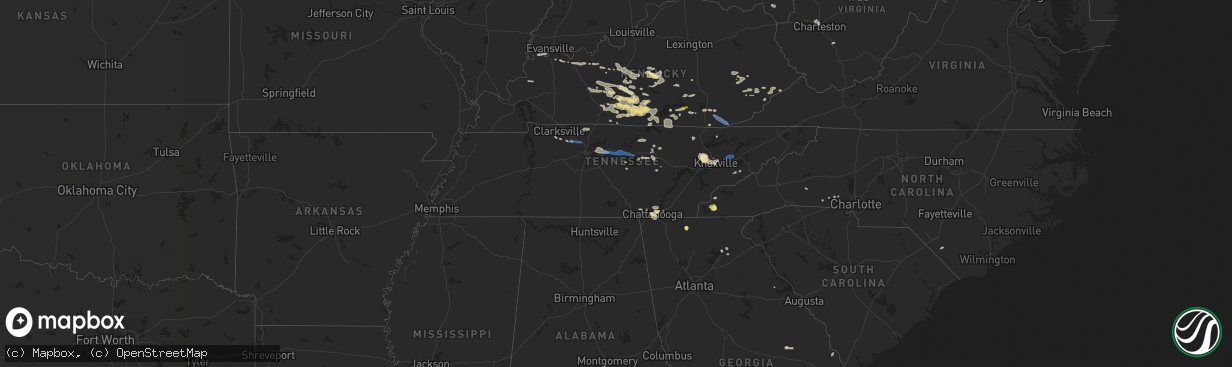
Hail Map in Tennessee on July 20, 2022
The weather event in Tennessee on July 20, 2022 includes Hail, Tornado, and Wind maps. 21 states and 450 cities were impacted and suffered possible damage. The total estimated number of properties impacted is 0.
Want more than just the map?
Turn this storm into a full workflow.
- Owner + property data so you know who to knock
- OnDemand branded weather history reports to win the "did we even have hail?" argument
- RoofTrace estimate so reps stop guessing numbers at the door
Bought this map? Upgrade within 7 days and we'll credit the $230. (10-15 min setup call)
Hail
Tornado
Wind
0
Estimated number of impacted properties by a 1.00" hail or larger0
Estimated number of impacted properties by a 1.75" hail or larger0
Estimated number of impacted properties by a 2.50" hail or largerStorm reports in Tennessee
Tennessee
| Date | Description |
|---|---|
| 07/20/20223:45 AM CDT | Several trees were blown down in putnam county including one across burgess falls rd. |
| 07/20/20223:00 AM CDT | Trees were blown down. |
| 07/20/20222:50 AM CDT | A tree and several limbs were blown down. |
| 07/20/20222:30 AM CDT | More than 100 trees were blown down... Some power poles were downed... And several incidents of minor structure damage were reported. |
| 07/20/20222:30 AM CDT | Numerous trees and a few power poles were blown down across pickett county. |
| 07/20/20222:30 AM CDT | Numerous trees and some power poles were blown down across overton county. |
| 07/20/20222:05 AM CDT | The door on a pole barn was blown in and there was damage to the sheet metal roof. |
| 07/20/20221:00 AM CDT | Trees down along highway 33. |
| 07/20/202212:46 AM CDT | Widespread trees down around piney road in western jefferson county. |
| 07/20/202212:46 AM CDT | Nws employee reports trees down near highway 11e in jefferson county. |
| 07/20/202212:40 AM CDT | At 540 PM CDT, a severe thunderstorm was located near Jasper, moving southeast at 15 mph. HAZARD...60 mph wind gusts. SOURCE...Radar indicated. IMPACT...Expect damage to roofs, siding, and trees. Locations impacted include... Jasper, Whitwell, Powells Crossroads, Martin Springs, Sequatchie Cave, Haletown (guild) and Hicks Gap State Park. |
| 07/19/202211:45 PM CDT | Public reports a few trees down. |
All States Impacted by Hail Map on July 20, 2022
Cities Impacted by Hail Map on July 20, 2022
- Cogswell, ND
- Britton, SD
- Oakes, ND
- Big Stone City, SD
- Milbank, SD
- Wilmot, SD
- Corona, SD
- Lebanon, TN
- Mount Juliet, TN
- Isle Saint George, OH
- Oregon, OH
- Harbor View, OH
- Middle Bass, OH
- Toledo, OH
- Curtice, OH
- Clayhole, KY
- Berlin Center, OH
- Diamond, OH
- Warren, OH
- Youngstown, OH
- Lake Milton, OH
- Newton Falls, OH
- North Jackson, OH
- Nevada, OH
- Bucyrus, OH
- Ashcamp, KY
- Shelby Gap, KY
- Morris, MN
- Cyrus, MN
- Donnelly, MN
- Warsaw, OH
- Eastview, KY
- Parkers Lake, KY
- Burkesville, KY
- Celina, TN
- Young, AZ
- Gwinner, ND
- Stirum, ND
- Peever, SD
- Sisseton, SD
- Ravenna, OH
- Crestline, OH
- Mansfield, OH
- Rocky Ford, CO
- Mount Sherman, KY
- Dundas, MN
- Faribault, MN
- Northfield, MN
- Hilton Head Island, SC
- Cuthbert, GA
- Shellman, GA
- Mineral Wells, WV
- Walker, WV
- Elizabeth, WV
- Lamoure, ND
- Campbellsville, KY
- Grand Isle, VT
- South Hero, VT
- Herman, MN
- Wheaton, MN
- Greensburg, KY
- Gambier, OH
- Mount Vernon, OH
- Howard, OH
- Marlette, MI
- Fort Branch, IN
- Princeton, IN
- Leitchfield, KY
- Brownsville, KY
- Ashland City, TN
- Chapmansboro, TN
- Owensboro, KY
- Gays Creek, KY
- Jackson, KY
- Marion, ND
- Colorado Springs, CO
- Sandusky, MI
- Applegate, MI
- Brown City, MI
- Carsonville, MI
- Croswell, MI
- Peck, MI
- Monticello, KY
- Tiffin, OH
- Lake City, SD
- Langford, SD
- Eden, SD
- Alto, GA
- Lula, GA
- Manzanola, CO
- Olney Springs, CO
- Magnolia, KY
- Bonnieville, KY
- Bronston, KY
- Burnside, KY
- Petroleum, WV
- Munfordville, KY
- Speedwell, TN
- Whick, KY
- Lost Creek, KY
- Corbin, KY
- Monterey, TN
- Baltimore, OH
- Carroll, OH
- Pleasantville, OH
- Philpot, KY
- Utica, KY
- Reynolds Station, KY
- Whitesville, KY
- Whitesburg, KY
- Eolia, KY
- Cecilia, KY
- Glendale, KY
- Buffalo, KY
- Hodgenville, KY
- Sonora, KY
- Elizabethtown, KY
- Union Mills, NC
- Carmi, IL
- Big Clifty, KY
- Virgie, KY
- Thornton, KY
- Jackhorn, KY
- Neon, KY
- McRoberts, KY
- Millstone, KY
- Jenkins, KY
- Fordsville, KY
- Fostoria, MI
- North Branch, MI
- Otter Lake, MI
- Mayer, AZ
- Holly, MI
- Fenton, MI
- Odessa, MN
- Bellingham, MN
- Madison, MN
- Upper Sandusky, OH
- Edgeley, ND
- Jud, ND
- Dawson, MN
- Watson, MN
- Montevideo, MN
- Mount Gilead, OH
- Cardington, OH
- Marion, KY
- Crab Orchard, KY
- Brodhead, KY
- Whitley City, KY
- Goreville, IL
- Buncombe, IL
- Vienna, IL
- Reader, WV
- Pine Grove, WV
- Powellton, WV
- Montgomery, WV
- Gallagher, WV
- Monroeville, OH
- Plymouth, OH
- Republic, OH
- Attica, OH
- Bloomville, OH
- Willard, OH
- McClure, IL
- Ullin, IL
- Tamms, IL
- Jonesboro, IL
- Cairo, IL
- Maybee, MI
- Willis, MI
- Carleton, MI
- Belleville, MI
- Milan, MI
- Bowling Green, KY
- Mammoth Cave, KY
- Sweeden, KY
- Smiths Grove, KY
- Pall Mall, TN
- Albany, KY
- Williamsburg, KY
- Ocklawaha, FL
- Sparta, TN
- Palm Coast, FL
- Claire City, SD
- Forman, ND
- Havana, ND
- Veblen, SD
- Rutland, ND
- Cayuga, ND
- Lindsay, TX
- Gainesville, TX
- Muenster, TX
- Hardyville, KY
- Horse Cave, KY
- Fullerton, ND
- Norwich, OH
- Chandlersville, OH
- New Concord, OH
- Viper, KY
- Centerburg, OH
- Marengo, OH
- Rickman, TN
- Hebron, OH
- Kirkersville, OH
- Millersport, OH
- Pickerington, OH
- Reynoldsburg, OH
- Pataskala, OH
- Upton, KY
- Robbinsville, NC
- North Street, MI
- Charleston, WV
- Smilax, KY
- Southside, TN
- Sevierville, TN
- Kit Carson, CO
- McDaniels, KY
- Hudson, KY
- Westview, KY
- Yosemite, KY
- Kings Mountain, KY
- Waynesburg, KY
- Liberty, KY
- Swainsboro, GA
- Ooltewah, TN
- Port Orange, FL
- Daytona Beach, FL
- Mims, FL
- Cass City, MI
- Blissfield, OH
- Coshocton, OH
- Rocky Hill, KY
- Knob Lick, KY
- Eighty Eight, KY
- Etoile, KY
- Fountain Run, KY
- Breeding, KY
- Columbia, KY
- Edmonton, KY
- Oakland, KY
- Cub Run, KY
- Bee Spring, KY
- Austin, KY
- Lucas, KY
- Center, KY
- Jamestown, KY
- Caneyville, KY
- Park City, KY
- Mount Hermon, KY
- Clarkson, KY
- Alvaton, KY
- Glasgow, KY
- Beaumont, KY
- Summer Shade, KY
- Cave City, KY
- Tompkinsville, KY
- Gradyville, KY
- Scottsville, KY
- Morgantown, KY
- Ida, MI
- Monroe, MI
- Petersburg, MI
- Dundee, MI
- Columbiaville, MI
- Port Austin, MI
- Linden, MI
- Byron, MI
- Grand Blanc, MI
- Summit, SD
- Twin Brooks, SD
- Whipple, OH
- Canton, MN
- Wooton, KY
- Hazard, KY
- Galion, OH
- Falls Of Rough, KY
- Hardinsburg, KY
- Somerset, KY
- Corydon, KY
- Golconda, IL
- Simpson, IL
- Ozark, IL
- Woodbine, KY
- Crossville, TN
- Green Springs, OH
- Ortonville, MN
- Kent, OH
- Holland, KY
- Crawford, TN
- Marble, NC
- Murphy, NC
- Bessemer City, NC
- Bluffton, SC
- Silver City, NM
- Buckhorn, NM
- Gainesville, GA
- Hixson, TN
- Chattanooga, TN
- Twin City, GA
- Wadmalaw Island, SC
- Rossville, GA
- Fort Oglethorpe, GA
- Ringgold, GA
- Oak Ridge, TN
- Knoxville, TN
- Powell, TN
- Clinton, TN
- Pearce, AZ
- Cochise, AZ
- West Lafayette, OH
- Shorterville, AL
- Abbeville, AL
- Ellijay, GA
- Willcox, AZ
- Cookeville, TN
- Hilham, TN
- Gainesboro, TN
- Dowelltown, TN
- Canmer, KY
- Payson, AZ
- Oak Hill, FL
- Bunnell, FL
- Flagler Beach, FL
- Ormond Beach, FL
- Raywick, KY
- Calhan, CO
- Pine Top, KY
- Springfield, TN
- Henderson, KY
- Coeburn, VA
- Sequatchie, TN
- Whitwell, TN
- Shelby, NC
- Rye, CO
- Big Prairie, OH
- Shreve, OH
- Lakeville, OH
- Loudonville, OH
- Jetson, KY
- Huntsville, TN
- Pioneer, TN
- Kissimmee, FL
- Rhine, GA
- Chauncey, GA
- Eastman, GA
- Evansville, IN
- Haubstadt, IN
- Cumberland Furnace, TN
- Palmyra, TN
- Cunningham, TN
- Sherman, TX
- Whitesboro, TX
- Howe, TX
- Daufuskie Island, SC
- Saint Jo, TX
- Prescott Valley, AZ
- Heiskell, TN
- Pedro, OH
- Evergreen, NC
- Christmas, FL
- Rossford, OH
- Barbourville, KY
- Gray, KY
- Herod, IL
- Eddyville, IL
- Howard, CO
- Roundhill, KY
- Adolphus, KY
- Orlando, FL
- Dallas, NC
- Smithville, TN
- Usaf Academy, CO
- Sassafras, KY
- Vicco, KY
- Redfox, KY
- Baltic, OH
- Millersburg, OH
- Fresno, OH
- Glenmont, OH
- Killbuck, OH
- Dongola, IL
- Anna, IL
- Fort McCoy, FL
- Bradfordsville, KY
- Lebanon, KY
- Edgewater, FL
- Fredericktown, OH
- Ashley, OH
- Science Hill, KY
- Flagstaff, AZ
- Quaker City, OH
- Salesville, OH
- Lore City, OH
- White House, TN
- Cross Plains, TN
- Booneville, KY
- Strawn, TX
- Cherryville, NC
- Kings Mountain, NC
- Gillsville, GA
- Washington, GA
- Edisto Island, SC
- Bridgeport, TX
- Clyo, GA
- Springfield, GA
- Milan, GA
- Conesville, OH
- Springfield, KY
- Loretto, KY
- New Smyrna Beach, FL
- Briceville, TN
- Oliver Springs, TN
- Stonefort, IL
- Mormon Lake, AZ
- Elk Horn, KY
- Gravel Switch, KY
- Letart, WV
- West Columbia, WV
- Harrison, TN
- Starbuck, MN
- Farwell, MN
- Rockholds, KY
- Bryants Store, KY
- Pineville, KY
- Calvin, KY
- Trosper, KY
- Middlesboro, KY
- Strawberry Plains, TN
- New Market, TN
- Joelton, TN
- Whites Creek, TN
- Pleasant View, TN
- Buffalo Valley, TN
- Gordonsville, TN
- Lancaster, TN
- Hickman, TN
- Brush Creek, TN
- Alexandria, TN
- Watertown, TN
- Silver Point, TN
- New Boston, MI
- Romulus, MI
- Detroit, MI
- Lidgerwood, ND
- Marvin, SD
- Tiro, OH
- Lucas, OH
- Holmesville, OH
- Fountain, CO
- Pueblo, CO


