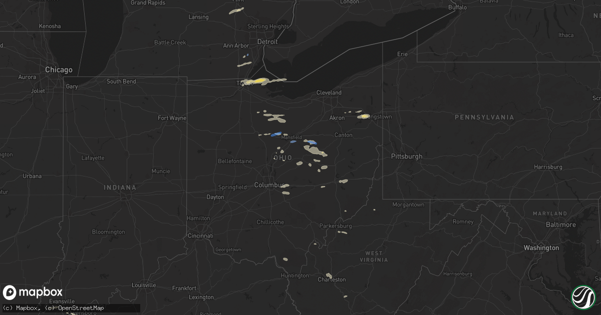
Hail Map in Ohio on July 20, 2022
Get this storm
July 20 map
$229
one time, instant access
Download today. No call, no setup
Keep the $229
Bought the map and want the full workflow? Apply the entire $229 to a subscription within 7 days. None of it is wasted.
Every map, not just this one
This buys you this map. Subscription and you get every map we run, in the markets you choose from a few cities to whole states to nationwide. Plus real-time alerts the moment a storm fires.
Contact data
Name, contact info, occupancy, even credit band for addresses in the footprint. You go from where it hit to who to call.
Become the source they trust
Unlimited branding weather history reports on demand. You already have the documented answer ready for the property owner, and you are the one who showed up with it.
Property data and RoofTrace estimates
Pull up any address you have got, its value and the exact code rules for that jurisdiction, straight from One Click Code. Then RoofTrace estimates the squares, pitch, and roof value, priced the way you price.
Storm reports in Ohio
Ohio
| Date | Description |
|---|---|
| 07/20/20226:56 PM CDT | Delayed report - tree down on cable. |
| 07/20/20226:54 PM CDT | Delayed report - tree down. |
| 07/20/20226:07 PM CDT | Delayed report. Tree downed onto road. Time estimated via radar. |
| 07/20/20225:52 PM CDT | 2 foot diameter tree down and blocking tiffen ave in willard. Time estimated via radar. |
| 07/20/20226:34 AM CDT | At 1133 PM EDT, a severe thunderstorm was located near Bremen, or 7 miles west of Somerset, moving southeast at 30 mph. HAZARD...60 mph wind gusts. SOURCE...Radar indicated. IMPACT...Expect damage to roofs, siding, and trees. Locations impacted include... New Lexington, Somerset, Shawnee, Perry State Forest, Crooksville, Junction City, New Straitsville, Corning, Hemlock and Rendville. |
| 07/20/20226:21 AM CDT | At 1121 PM EDT, a severe thunderstorm was located over Baltimore, moving east at 30 mph. HAZARD...60 mph wind gusts. SOURCE...Radar indicated. IMPACT...Expect damage to trees and power lines. Locations impacted include... Lancaster, Canal Winchester, Baltimore, Bremen, Millersport, Pleasantville, Hide-A-Way Hills, Royalton, Lithopolis, Amanda, Thurston, Carroll, Sugar Grove, Rushville, West Rushville, Fairfield County Airport, Hideaway Hills, Clearport and North Berne. |
| 07/20/20225:49 AM CDT | At 1048 PM EDT, severe thunderstorms were located along a line extending from near Farmerstown to near Coshocton to 6 miles northwest of Frazeysburg, moving east at 40 mph. HAZARD...60 mph wind gusts. SOURCE...Radar indicated. IMPACT...Expect damage to trees and power lines, resulting in some power outages. Locations impacted include... Zanesville, Coshocton, Cambridge, Cadiz, Freeport, Newcomerstown, New Concord, Byesville, West Lafayette, North Zanesville, Dresden, and Frazeysburg. |
| 07/20/20225:19 AM CDT | At 1018 PM EDT, severe thunderstorms were located along a line extending from 6 miles southwest of Utica to near Upper Arlington, moving east at 40 mph. HAZARD...60 mph wind gusts. SOURCE...Radar indicated. IMPACT...Expect damage to trees and power lines. Locations impacted include... Columbus, Newark, Dublin, Westerville, Reynoldsburg, Upper Arlington, Gahanna, Hilliard, Worthington, Bexley, Heath, Granville, Pataskala, Johnstown, Hebron, Utica, Minerva Park, Hanover, Granville South and Marne.This includes the following Interstates... I-70 in Ohio between mile markers 91 and 103, and between milemarkers 113 and 124. I-71 in Ohio between mile markers 106 and 121. |
| 07/20/20225:04 AM CDT | At 1004 PM EDT, a severe thunderstorm was located over Canfield, or 7 miles west of Youngstown, moving east at 40 mph. HAZARD...60 mph wind gusts and penny size hail. SOURCE...Radar indicated. IMPACT...Expect damage to trees and power lines. Locations impacted include... Youngstown, Boardman, Niles, Campbell, Hubbard, Canfield, Lordstown, Hilltop, Maplewood Park, Austintown, Struthers, Girard, McDonald, Poland, Ellsworth, Lowellville, North Jackson, Churchill and Mineral Ridge. |
| 07/20/20224:54 AM CDT | At 954 PM EDT, severe thunderstorms were located along a line extending from 6 miles south of Waynesburg to near Farmerstown to near Danville, moving east at 40 mph. HAZARD...60 mph wind gusts and quarter size hail. SOURCE...Radar indicated. IMPACT...Minor hail damage to vehicles is possible. Expect wind damage to trees and power lines, resulting in some power outages. Locations impacted include... New Philadelphia, Dover, Coshocton, Uhrichsville, Cadiz, Carrollton, Wintersville, Newcomerstown, Dennison, Strasburg, West Lafayette, and Sugarcreek. |
| 07/20/20224:22 AM CDT | At 921 PM EDT, a severe thunderstorm was located over Winesburg, or 11 miles east of Millersburg, moving east at 40 mph. HAZARD...60 mph wind gusts. SOURCE...Radar indicated. IMPACT...Expect damage to trees and power lines. Locations impacted include... Berlin, Walnut Creek, Brewster, Navarre, Waynesburg, East Sparta, Wilmot, Winesburg, Farmerstown, Beach City, Baltic, Charm and Mount Hope. |
| 07/20/20224:17 AM CDT | At 917 PM EDT, a severe thunderstorm was located over Berlin, or near Millersburg, moving east at 40 mph. HAZARD...60 mph wind gusts and quarter size hail. SOURCE...Radar indicated. IMPACT...Minor hail damage to vehicles is possible. Expect wind damage to trees and power lines, resulting in some power outages. Locations impacted include... New Philadelphia, Dover, Uhrichsville, Dennison, Strasburg, Sugarcreek, Gnadenhutten, Tuscarawas, Bolivar, Baltic, Midvale, and Mineral City. |
| 07/20/20223:30 AM CDT | At 830 PM EDT, a severe thunderstorm was located over Hayesville, or 9 miles southeast of Ashland, moving east at 25 mph. HAZARD...60 mph wind gusts. SOURCE...Radar indicated. IMPACT...Expect damage to trees and power lines. Locations impacted include... Ashland, Loudonville, Hayesville, Perrysville, Jeromesville and Mohicanville. |
| 07/20/20223:18 AM CDT | At 818 PM EDT, severe thunderstorms were located along a line extending from near West Salem to near Shreve to 6 miles west of Loudonville, moving southeast at 35 mph. HAZARD...60 mph wind gusts. SOURCE...Radar indicated. IMPACT...Expect damage to trees and power lines. Locations impacted include... Wooster, Millersburg, Orrville, Berlin, Walnut Creek, Loudonville, Dalton, Shreve, Killbuck, Holmesville, Glenmont, Mount Eaton, Nashville, Winesburg, Farmerstown, Smithville, Apple Creek, Baltic, Fredericksburg and Mount Hope. |
| 07/20/20223:00 AM CDT | At 759 PM EDT, a severe thunderstorm was located near Shauck, or near Mount Gilead, moving east at 35 mph. HAZARD...60 mph wind gusts. SOURCE...Radar indicated. IMPACT...Expect damage to trees and power lines. Locations impacted include... Mount Gilead, Lexington, Loudonville, Fredericktown, Cardington, Bellville, Waterford, Butler, Caledonia, Edison, Gann, North Liberty, Iberia and Shauck. |
| 07/20/20222:53 AM CDT | At 753 PM EDT, severe thunderstorms were located along a line extending from Strongsville to Brunswick to Medina, moving east at 35 mph. HAZARD...60 mph wind gusts. SOURCE...Radar indicated. IMPACT...Expect damage to trees and power lines. Locations impacted include... Cleveland, Akron, Medina, Parma, Cuyahoga Falls, Strongsville, Brunswick, North Royalton, Kent, Solon, Hudson, Twinsburg, Streetsboro, Warrensville Heights, Macedonia, South Russell, Highland Hills, Stow, Garfield Heights and Maple Heights. |
| 07/20/20222:22 AM CDT | At 721 PM EDT, severe thunderstorms were located along a line extending from near New London to 7 miles west of Ashland to Crestline, moving east at 25 mph. HAZARD...60 mph wind gusts. SOURCE...Radar indicated. IMPACT...Expect damage to trees and power lines. Locations impacted include... Mansfield, Wooster, Ashland, Galion, Ontario, Crestline, Lodi, New London, West Salem, Hayesville, Savannah, Polk, Sullivan, Westfield Center, Lucas, Jeromesville, Bailey Lakes, Burbank, Congress and Mifflin. |
| 07/20/20221:57 AM CDT | At 657 PM EDT, a severe thunderstorm was located 8 miles north of Lakewood, or 10 miles northwest of Cleveland, moving east at 45 mph. HAZARD...60 mph wind gusts and penny size hail. SOURCE...Radar indicated. IMPACT...Expect damage to trees and power lines. Locations impacted include... Cleveland, Painesville, Willowick, Chardon, Fairport Harbor, Lakewood, Euclid, Mentor, Cleveland Heights, Westlake, Solon, Willoughby, Eastlake, Warrensville Heights, South Russell, Madison, Middlefield, Burton, Highland Hills and Timberlake. |
| 07/20/20221:28 AM CDT | At 628 PM EDT, a severe thunderstorm was located near Willard, or 16 miles southwest of Norwalk, moving east at 25 mph. HAZARD...60 mph wind gusts and penny size hail. SOURCE...Radar indicated. IMPACT...Expect damage to trees and power lines. Locations impacted include... Ashland, Shelby, Willard, New London, Plymouth, New Washington, Savannah, Chatfield, Greenwich, Attica, North Fairfield, Bailey Lakes, Rochester, Nova, Shenandoah and Olivesburg. |
| 07/20/202212:58 AM CDT | At 558 PM EDT, a severe thunderstorm was located near Green Springs, or 11 miles southeast of Fremont, moving east at 20 mph. HAZARD...60 mph wind gusts and penny size hail. SOURCE...Radar indicated. IMPACT...Expect damage to trees and power lines. Locations impacted include... Norwalk, Bellevue, Clyde, Green Springs, Milan, Northern Milan, Monroeville, Berlin Heights, Republic and Flat Rock. |
| 07/19/202210:55 PM CDT | A few large limbs reported down in and around town. |
| 07/19/202210:33 PM CDT | Reports of multiple trees down. Time est from radar. |
| 07/19/202210:21 PM CDT | At 321 PM EDT, a severe thunderstorm was located near Oregon, or near Toledo, moving east at 40 mph. HAZARD...60 mph wind gusts. SOURCE...Radar indicated. IMPACT...Expect damage to trees and power lines. Locations impacted include... Toledo, Oregon, Sylvania, Northwood, Holland, Maumee, Ottawa Hills, Harbor View, Reno Beach and Bono. |
| 07/19/202210:20 PM CDT | Large tree down near sr60 and shannon road. |
| 07/19/202210:05 PM CDT | Several power poles snapped near the 11000 block of lancaster-newark road ne. Several large tree branches also downed in the area. Time estimated by radar. |
| 07/19/202210:00 PM CDT | Two trees down on state route 60. Time estimated from radar. |
| 07/19/20229:50 PM CDT | Snapped power pole and tree damage near intersection of sr 751 and coshocton county road. Time estimated from radar. |
| 07/19/20229:47 PM CDT | Tree down on hudson ave between oak st and st clair st |
| 07/19/20229:22 PM CDT | Tree down on state route 151. Time estimated from radar. |
| 07/19/20229:10 PM CDT | Numerous trees down along pritchard ohltown road. |
| 07/19/20229:06 PM CDT | Two trees down on state route 9 near town. Time estimated from radar. |
| 07/19/20227:58 PM CDT | Video from storm chaser on twitter shows multiple trees that were snapped or had large limbs snapped off part way up along sr 83 east of shreve. Time estimated via rada |
| 07/19/20227:57 PM CDT | Large tree down on sr 514 south of cr 1. |
| 07/19/20227:57 PM CDT | Tree downed on road just south of shreve in northern holmes county. Time estimated via radar. |
| 07/19/20227:57 PM CDT | Centerville/county line rd closed due to downed trees and wires between route 226 and route 83. Time estimated via radar. |
| 07/19/20227:20 PM CDT | *delayed report* several hardwood trees downed on 6000 block of clever rd. |
| 07/19/20227:15 PM CDT | Several tree limbs and trees down. |
All States Impacted by Hail Map on July 20, 2022
Cities Impacted by Hail Map on July 20, 2022
- Cogswell, ND
- Britton, SD
- Oakes, ND
- Big Stone City, SD
- Milbank, SD
- Wilmot, SD
- Corona, SD
- Lebanon, TN
- Mount Juliet, TN
- Isle Saint George, OH
- Oregon, OH
- Harbor View, OH
- Middle Bass, OH
- Toledo, OH
- Curtice, OH
- Clayhole, KY
- Berlin Center, OH
- Diamond, OH
- Warren, OH
- Youngstown, OH
- Lake Milton, OH
- Newton Falls, OH
- North Jackson, OH
- Nevada, OH
- Bucyrus, OH
- Ashcamp, KY
- Shelby Gap, KY
- Morris, MN
- Cyrus, MN
- Donnelly, MN
- Warsaw, OH
- Eastview, KY
- Parkers Lake, KY
- Burkesville, KY
- Celina, TN
- Young, AZ
- Gwinner, ND
- Stirum, ND
- Peever, SD
- Sisseton, SD
- Ravenna, OH
- Crestline, OH
- Mansfield, OH
- Rocky Ford, CO
- Mount Sherman, KY
- Dundas, MN
- Faribault, MN
- Northfield, MN
- Hilton Head Island, SC
- Cuthbert, GA
- Shellman, GA
- Mineral Wells, WV
- Walker, WV
- Elizabeth, WV
- Lamoure, ND
- Campbellsville, KY
- Grand Isle, VT
- South Hero, VT
- Herman, MN
- Wheaton, MN
- Greensburg, KY
- Gambier, OH
- Mount Vernon, OH
- Howard, OH
- Marlette, MI
- Fort Branch, IN
- Princeton, IN
- Leitchfield, KY
- Brownsville, KY
- Ashland City, TN
- Chapmansboro, TN
- Owensboro, KY
- Gays Creek, KY
- Jackson, KY
- Marion, ND
- Colorado Springs, CO
- Sandusky, MI
- Applegate, MI
- Brown City, MI
- Carsonville, MI
- Croswell, MI
- Peck, MI
- Monticello, KY
- Tiffin, OH
- Lake City, SD
- Langford, SD
- Eden, SD
- Alto, GA
- Lula, GA
- Manzanola, CO
- Olney Springs, CO
- Magnolia, KY
- Bonnieville, KY
- Bronston, KY
- Burnside, KY
- Petroleum, WV
- Munfordville, KY
- Speedwell, TN
- Whick, KY
- Lost Creek, KY
- Corbin, KY
- Monterey, TN
- Baltimore, OH
- Carroll, OH
- Pleasantville, OH
- Philpot, KY
- Utica, KY
- Reynolds Station, KY
- Whitesville, KY
- Whitesburg, KY
- Eolia, KY
- Cecilia, KY
- Glendale, KY
- Buffalo, KY
- Hodgenville, KY
- Sonora, KY
- Elizabethtown, KY
- Union Mills, NC
- Carmi, IL
- Big Clifty, KY
- Virgie, KY
- Thornton, KY
- Jackhorn, KY
- Neon, KY
- McRoberts, KY
- Millstone, KY
- Jenkins, KY
- Fordsville, KY
- Fostoria, MI
- North Branch, MI
- Otter Lake, MI
- Mayer, AZ
- Holly, MI
- Fenton, MI
- Odessa, MN
- Bellingham, MN
- Madison, MN
- Upper Sandusky, OH
- Edgeley, ND
- Jud, ND
- Dawson, MN
- Watson, MN
- Montevideo, MN
- Mount Gilead, OH
- Cardington, OH
- Marion, KY
- Crab Orchard, KY
- Brodhead, KY
- Whitley City, KY
- Goreville, IL
- Buncombe, IL
- Vienna, IL
- Reader, WV
- Pine Grove, WV
- Powellton, WV
- Montgomery, WV
- Gallagher, WV
- Monroeville, OH
- Plymouth, OH
- Republic, OH
- Attica, OH
- Bloomville, OH
- Willard, OH
- McClure, IL
- Ullin, IL
- Tamms, IL
- Jonesboro, IL
- Cairo, IL
- Maybee, MI
- Willis, MI
- Carleton, MI
- Belleville, MI
- Milan, MI
- Bowling Green, KY
- Mammoth Cave, KY
- Sweeden, KY
- Smiths Grove, KY
- Pall Mall, TN
- Albany, KY
- Williamsburg, KY
- Ocklawaha, FL
- Sparta, TN
- Palm Coast, FL
- Claire City, SD
- Forman, ND
- Havana, ND
- Veblen, SD
- Rutland, ND
- Cayuga, ND
- Lindsay, TX
- Gainesville, TX
- Muenster, TX
- Hardyville, KY
- Horse Cave, KY
- Fullerton, ND
- Norwich, OH
- Chandlersville, OH
- New Concord, OH
- Viper, KY
- Centerburg, OH
- Marengo, OH
- Rickman, TN
- Hebron, OH
- Kirkersville, OH
- Millersport, OH
- Pickerington, OH
- Reynoldsburg, OH
- Pataskala, OH
- Upton, KY
- Robbinsville, NC
- North Street, MI
- Charleston, WV
- Smilax, KY
- Southside, TN
- Sevierville, TN
- Kit Carson, CO
- McDaniels, KY
- Hudson, KY
- Westview, KY
- Yosemite, KY
- Kings Mountain, KY
- Waynesburg, KY
- Liberty, KY
- Swainsboro, GA
- Ooltewah, TN
- Port Orange, FL
- Daytona Beach, FL
- Mims, FL
- Cass City, MI
- Blissfield, OH
- Coshocton, OH
- Rocky Hill, KY
- Knob Lick, KY
- Eighty Eight, KY
- Etoile, KY
- Fountain Run, KY
- Breeding, KY
- Columbia, KY
- Edmonton, KY
- Oakland, KY
- Cub Run, KY
- Bee Spring, KY
- Austin, KY
- Lucas, KY
- Center, KY
- Jamestown, KY
- Caneyville, KY
- Park City, KY
- Mount Hermon, KY
- Clarkson, KY
- Alvaton, KY
- Glasgow, KY
- Beaumont, KY
- Summer Shade, KY
- Cave City, KY
- Tompkinsville, KY
- Gradyville, KY
- Scottsville, KY
- Morgantown, KY
- Ida, MI
- Monroe, MI
- Petersburg, MI
- Dundee, MI
- Columbiaville, MI
- Port Austin, MI
- Linden, MI
- Byron, MI
- Grand Blanc, MI
- Summit, SD
- Twin Brooks, SD
- Whipple, OH
- Canton, MN
- Wooton, KY
- Hazard, KY
- Galion, OH
- Falls Of Rough, KY
- Hardinsburg, KY
- Somerset, KY
- Corydon, KY
- Golconda, IL
- Simpson, IL
- Ozark, IL
- Woodbine, KY
- Crossville, TN
- Green Springs, OH
- Ortonville, MN
- Kent, OH
- Holland, KY
- Crawford, TN
- Marble, NC
- Murphy, NC
- Bessemer City, NC
- Bluffton, SC
- Silver City, NM
- Buckhorn, NM
- Gainesville, GA
- Hixson, TN
- Chattanooga, TN
- Twin City, GA
- Wadmalaw Island, SC
- Rossville, GA
- Fort Oglethorpe, GA
- Ringgold, GA
- Oak Ridge, TN
- Knoxville, TN
- Powell, TN
- Clinton, TN
- Pearce, AZ
- Cochise, AZ
- West Lafayette, OH
- Shorterville, AL
- Abbeville, AL
- Ellijay, GA
- Willcox, AZ
- Cookeville, TN
- Hilham, TN
- Gainesboro, TN
- Dowelltown, TN
- Canmer, KY
- Payson, AZ
- Oak Hill, FL
- Bunnell, FL
- Flagler Beach, FL
- Ormond Beach, FL
- Raywick, KY
- Calhan, CO
- Pine Top, KY
- Springfield, TN
- Henderson, KY
- Coeburn, VA
- Sequatchie, TN
- Whitwell, TN
- Shelby, NC
- Rye, CO
- Big Prairie, OH
- Shreve, OH
- Lakeville, OH
- Loudonville, OH
- Jetson, KY
- Huntsville, TN
- Pioneer, TN
- Kissimmee, FL
- Rhine, GA
- Chauncey, GA
- Eastman, GA
- Evansville, IN
- Haubstadt, IN
- Cumberland Furnace, TN
- Palmyra, TN
- Cunningham, TN
- Sherman, TX
- Whitesboro, TX
- Howe, TX
- Daufuskie Island, SC
- Saint Jo, TX
- Prescott Valley, AZ
- Heiskell, TN
- Pedro, OH
- Evergreen, NC
- Christmas, FL
- Rossford, OH
- Barbourville, KY
- Gray, KY
- Herod, IL
- Eddyville, IL
- Howard, CO
- Roundhill, KY
- Adolphus, KY
- Orlando, FL
- Dallas, NC
- Smithville, TN
- Usaf Academy, CO
- Sassafras, KY
- Vicco, KY
- Redfox, KY
- Baltic, OH
- Millersburg, OH
- Fresno, OH
- Glenmont, OH
- Killbuck, OH
- Dongola, IL
- Anna, IL
- Fort McCoy, FL
- Bradfordsville, KY
- Lebanon, KY
- Edgewater, FL
- Fredericktown, OH
- Ashley, OH
- Science Hill, KY
- Flagstaff, AZ
- Quaker City, OH
- Salesville, OH
- Lore City, OH
- White House, TN
- Cross Plains, TN
- Booneville, KY
- Strawn, TX
- Cherryville, NC
- Kings Mountain, NC
- Gillsville, GA
- Washington, GA
- Edisto Island, SC
- Bridgeport, TX
- Clyo, GA
- Springfield, GA
- Milan, GA
- Conesville, OH
- Springfield, KY
- Loretto, KY
- New Smyrna Beach, FL
- Briceville, TN
- Oliver Springs, TN
- Stonefort, IL
- Mormon Lake, AZ
- Elk Horn, KY
- Gravel Switch, KY
- Letart, WV
- West Columbia, WV
- Harrison, TN
- Starbuck, MN
- Farwell, MN
- Rockholds, KY
- Bryants Store, KY
- Pineville, KY
- Calvin, KY
- Trosper, KY
- Middlesboro, KY
- Strawberry Plains, TN
- New Market, TN
- Joelton, TN
- Whites Creek, TN
- Pleasant View, TN
- Buffalo Valley, TN
- Gordonsville, TN
- Lancaster, TN
- Hickman, TN
- Brush Creek, TN
- Alexandria, TN
- Watertown, TN
- Silver Point, TN
- New Boston, MI
- Romulus, MI
- Detroit, MI
- Lidgerwood, ND
- Marvin, SD
- Tiro, OH
- Lucas, OH
- Holmesville, OH
- Fountain, CO
- Pueblo, CO


