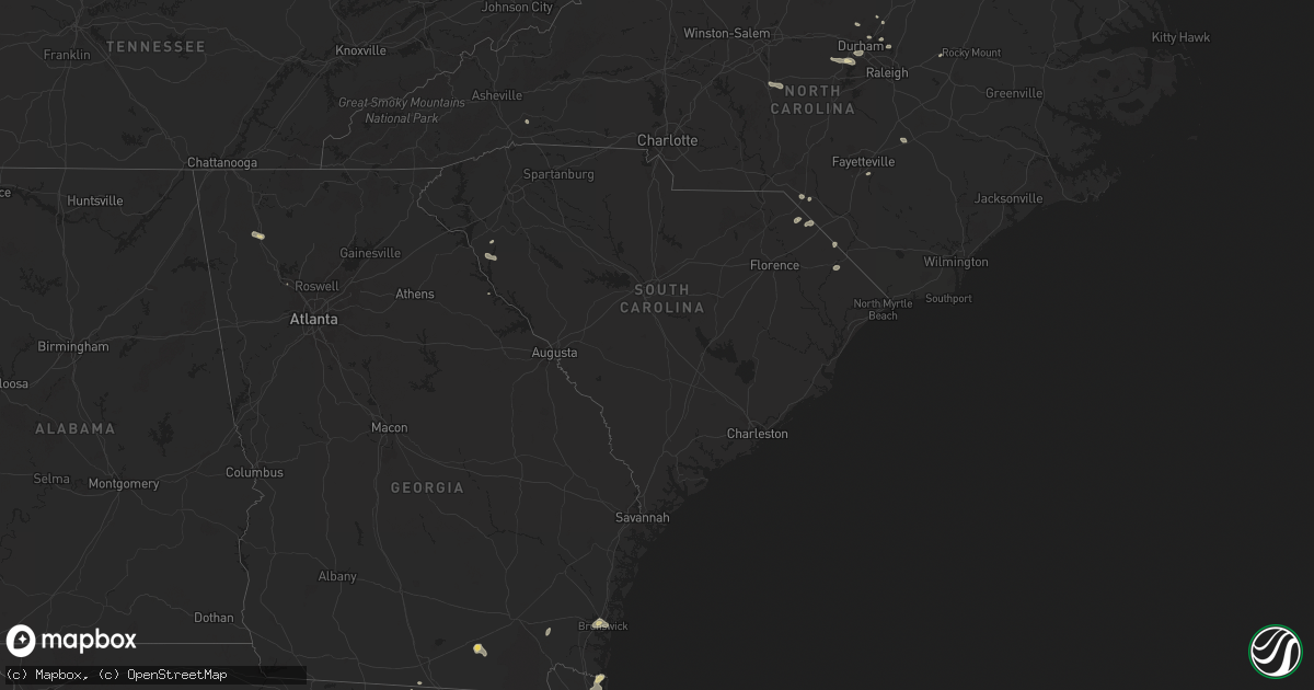
Hail Map in South Carolina on July 18, 2024
Get this storm
July 18 map
$229
one time, instant access
Download today. No call, no setup
Keep the $229
Bought the map and want the full workflow? Apply the entire $229 to a subscription within 7 days. None of it is wasted.
Every map, not just this one
This buys you this map. Subscription and you get every map we run, in the markets you choose from a few cities to whole states to nationwide. Plus real-time alerts the moment a storm fires.
Contact data
Name, contact info, occupancy, even credit band for addresses in the footprint. You go from where it hit to who to call.
Become the source they trust
Unlimited branding weather history reports on demand. You already have the documented answer ready for the property owner, and you are the one who showed up with it.
Property data and RoofTrace estimates
Pull up any address you have got, its value and the exact code rules for that jurisdiction, straight from One Click Code. Then RoofTrace estimates the squares, pitch, and roof value, priced the way you price.
Storm reports in South Carolina
South Carolina
| Date | Description |
|---|---|
| 07/18/20246:45 PM CDT | Sumter fire dept responding to a tree that fell on a vehicle on azalea ct. Time estimated from radar. |
| 07/18/20245:58 PM CDT | Sc dept of public safety reports trees down on emanuel church rd near the intersection of two notch rd. Time estimated from radar. |
| 07/18/20245:55 PM CDT | Richland county dispatch reports powerlines down on torwood dr. Scdps also reported a tree down in ne columbia on trenholm rd. |
| 07/18/20245:55 PM CDT | Corrects previous tstm wnd dmg report from 1 ene lexington. Adds additional damage in the same area. Retired nws employee reports a tree down near coventry lake dr and |
| 07/18/20244:39 PM CDT | Sc dept of public safety reports trees down on highway 34 near the intersection of broad river rd. |
| 07/18/20244:16 PM CDT | Tree down on roadway. |
| 07/18/20244:15 PM CDT | Multiple trees down on roadway. |
| 07/18/20244:00 PM CDT | Several trees and power lines down along highway 284. |
| 07/18/20243:55 PM CDT | Several trees and power lines down along lakeside drive. |
| 07/18/20243:23 PM CDT | Tree down in the clinton area. |
| 07/18/20243:03 PM CDT | Two large trees down along georgia rd. |
| 07/18/20243:03 PM CDT | 9 trees down and several power lines down across the gray court area. |
| 07/18/20242:30 PM CDT | Tree down on holiday dam rd. |
| 07/18/20242:20 PM CDT | Several trees and power lines down across the city of belton. |
All States Impacted by Hail Map on July 18, 2024
Cities Impacted by Hail Map on July 18, 2024
- Manor, TX
- Coupland, TX
- Elgin, TX
- Union, MS
- De Kalb, MS
- Collinsville, MS
- Napoleonville, LA
- Belle Rose, LA
- Pierre Part, LA
- White Castle, LA
- Rougemont, NC
- Stem, NC
- Kennesaw, GA
- Donaldsonville, LA
- Baton Rouge, LA
- Bahama, NC
- Walker, LA
- Lauderdale, MS
- Porterville, MS
- Denham Springs, LA
- Freeman, VA
- Lawrenceville, VA
- Wake Forest, NC
- Durham, NC
- Hendersonville, NC
- Emporia, VA
- Raleigh, NC
- Madison, FL
- Mill Spring, NC
- York, AL
- Cuba, AL
- Valdosta, GA
- Fargo, GA
- Gainesville, AL
- Carthage, MS
- Spring Hope, NC
- Homerville, GA
- Jarratt, VA
- Calhoun, GA
- Epes, AL
- Madisonville, LA
- Ponchatoula, LA
- Covington, LA
- Folsom, LA
- Bush, LA
- Plainville, GA
- Sedley, VA
- Franklin, VA
- Nahunta, GA
- Folkston, GA
- Dinwiddie, VA
- Dewitt, VA
- Chapel Hill, NC
- Adairsville, GA
- Guadalupita, NM
- Eagle Nest, NM
- Walnut Grove, MS
- Perkinston, MS
- Zuni, VA
- Mora, NM
- Punta Gorda, FL
- Apex, NC
- Yulee, FL
- Muleshoe, TX
- Jacksonville, FL
- Henderson, NV
- Fernandina Beach, FL
- Rainsville, NM
- Columbia, MS
- Brunswick, GA
- Saint Marys, GA
- Anderson, SC
- Iva, SC
- Dunn, NC
- Buena Vista, NM
- Estes Park, CO
- Abbeville, SC
- Pachuta, MS
- Rose Hill, MS
- Buffalo, MT
- Tuscaloosa, AL
- Hobson, MT
- Tignall, GA
- McLain, MS
- Myakka City, FL
- Laurinburg, NC
- Laurel Hill, NC
- Gibson, NC
- Cottondale, AL
- Cheyenne, WY
- Elkton, FL
- Sapello, NM
- Rociada, NM
- Hastings, FL
- Quitman, MS
- Ramah, CO
- Calhan, CO
- Dubois, ID
- Clio, SC
- McColl, SC
- Bennettsville, SC
- Montezuma, NM
- Saint Augustine, FL
- Shubuta, MS
- Lithia, FL
- Asheboro, NC
- Portales, NM
- Las Vegas, NM
- Newton Grove, NC
- Brooksville, FL
- Whitlash, MT
- Beulah, ND
- Aguilar, CO
- Fayetteville, NC
- Hope Mills, NC
- Little Rock, SC
- Dover, FL
- Plant City, FL
- Valrico, FL
- San Jose, NM
- Dillon, SC
- Hamer, SC
- Sylacauga, AL
- Hazen, ND
- Farwell, TX
- Chugwater, WY
- Ribera, NM
- Colorado Springs, CO
- La Veta, CO
- Elida, NM
- Gilbertown, AL
- Lake View, SC
- Seffner, FL
- Glorieta, NM
- Nichols, SC
- Mullins, SC
- Walsenburg, CO
- Peyton, CO
- Zephyrhills, FL
- Weogufka, AL
- Lagrange, WY
- Moriarty, NM
- Wagarville, AL
- Agate, CO
- Kathleen, FL
- Dade City, FL
- Briggsdale, CO
- Meriden, WY
- Simla, CO
- Wallace, KS
- New Raymer, CO
- Byers, CO
- Deer Trail, CO
- Albin, WY
- Fort McCoy, FL
- Leesburg, FL
- Miami, AZ
- Globe, AZ
- Musselshell, MT
- Trinchera, CO
- Matheson, CO
- Vail, AZ
- Crescent City, FL
- Custer, MT
- Branson, CO
- Claypool, AZ
- Sharon Springs, KS
- Lady Lake, FL
- Pine Bluffs, WY
- Harrisburg, NE
- Georgetown, FL
- Hysham, MT
- Tucson, AZ
- Limon, CO
- Umatilla, FL
- Genoa, CO
- Woodrow, CO
- Avondale, CO
- Fairmont, NC
- Winkelman, AZ
- Weskan, KS
- Sahuarita, AZ
- Bushnell, NE
- Estancia, NM
- Folsom, NM
- Arriba, CO
- Grenville, NM
- Bighorn, MT
- Wilton, ND
- Pittsboro, NC
- Creedmoor, NC
- Baldwin, ND
- Batesland, SD
- Martin, SD
- Allen, SD
- Wishek, ND
- Lehr, ND
- Agar, SD
- Gettysburg, SD
- Wausa, NE
- Bloomfield, NE
- Onida, SD
- Randolph, NE
- Hartington, NE
- Holabird, SD
- Highmore, SD
- Coleridge, NE
- Wanblee, SD
- Merriman, NE
- Lebanon, SD


