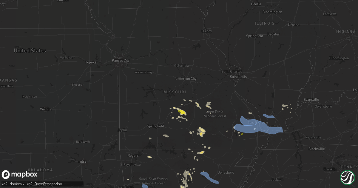
Hail Map in Missouri on July 17, 2022
Get this storm
July 17 map
$229
one time, instant access
Download today. No call, no setup
Keep the $229
Bought the map and want the full workflow? Apply the entire $229 to a subscription within 7 days. None of it is wasted.
Every map, not just this one
This buys you this map. Subscription and you get every map we run, in the markets you choose from a few cities to whole states to nationwide. Plus real-time alerts the moment a storm fires.
Contact data
Name, contact info, occupancy, even credit band for addresses in the footprint. You go from where it hit to who to call.
Become the source they trust
Unlimited branding weather history reports on demand. You already have the documented answer ready for the property owner, and you are the one who showed up with it.
Property data and RoofTrace estimates
Pull up any address you have got, its value and the exact code rules for that jurisdiction, straight from One Click Code. Then RoofTrace estimates the squares, pitch, and roof value, priced the way you price.
Storm reports in Missouri
Missouri
| Date | Description |
|---|---|
| 07/17/20226:46 PM CDT | Power line down. |
| 07/17/20226:36 PM CDT | Tree was downed near winona as the thunderstorms moved through that location. |
| 07/17/20224:40 PM CDT | Via social media...trees down estimated around 2140z. Photos provided. |
| 07/17/20223:55 PM CDT | Corrects previous tstm wnd dmg report from falcon. Delayed report from storms from sunday evening. Received a picture of a large tree that was uprooted near falcon miss |
| 07/17/20228:53 AM CDT | Six inch diameter branch blocking parking lot at kvfs-12. Relayed by kfvs-12. Time estimated by radar. |
| 07/17/20224:47 AM CDT | At 947 PM CDT, severe thunderstorms were located along a line extending from near Karnak to near Barkley Regional Airport to near Bardwell to near Anniston to near Big Oak Tree State Park, moving southeast at 45 mph. HAZARD...70 mph wind gusts and penny size hail. SOURCE...Radar indicated. IMPACT...Expect considerable tree damage. Damage is likely to mobile homes, roofs, and outbuildings. Severe thunderstorms will be near... Bardwell, Barkley Regional Airport, West Paducah and Lovelaceville around 955 PM CDT. Paducah and Lone Oak around 1000 PM CDT.Other locations in the path of these severe thunderstorms includeMetropolis, Clinton, Mayfield, Brookport, Reidland and Ledbetter.This includes the following highways... Interstate 24 in Kentucky between Mile Markers 1 and 16. Interstate 24 in Illinois between Mile Markers 24 and 38. Interstate 69 in Kentucky between Mile Markers 16 and 33. |
| 07/17/20223:28 AM CDT | At 827 PM CDT, a severe thunderstorm was located over Success, or near Corning, moving southeast at 30 mph. HAZARD...60 mph wind gusts. SOURCE...Radar indicated. IMPACT...Expect damage to roofs, siding, and trees. Locations impacted include... Piggott, Corning, Campbell, Rector, Chalk Bluff Natural Area, Reyno, Knobel, St. Francis, Pollard, Greenway, McDougal, Success, Peach Orchard, Datto, Glennonville, Saint Francis, Crockett, Stonewall, Tipperary and Hickoria. |
| 07/17/20222:56 AM CDT | At 756 PM CDT, a severe thunderstorm was located near Cobalt, moving southeast at 30 mph. HAZARD...60 mph wind gusts. SOURCE...Radar indicated. IMPACT...Expect damage to roofs, siding, and trees. This severe thunderstorm will be near... Marquand around 810 PM CDT. |
| 07/17/20222:48 AM CDT | At 747 PM CDT, a severe thunderstorm was located over Doniphan, moving southeast at 50 mph. HAZARD...60 mph wind gusts. SOURCE...Radar indicated. IMPACT...Expect damage to roofs, siding, and trees. Locations impacted include... Malden, Piggott, Corning, Campbell, Rector, Chalk Bluff Natural Area, Knobel, St. Francis, Pollard, Greenway, McDougal, Success, Datto, Glennonville, Saint Francis, Crockett, Heubner, Tipperary, Hickoria and Leonard. |
| 07/17/20222:33 AM CDT | At 732 PM CDT, severe thunderstorms were located along a line extending from 6 miles northeast of Ellsinore to near Milltown to 8 miles northwest of Doniphan, moving east at 40 mph. HAZARD...60 mph wind gusts and penny size hail. SOURCE...Radar indicated. IMPACT...Expect damage to roofs, siding, and trees. Severe thunderstorms will be near... Williamsville and Milltown around 740 PM CDT. Poplar Bluff around 745 PM CDT. Hendrickson, Harviell and Budapest around 750 PM CDT.Other locations in the path of these severe thunderstorms includeOxly, Lake Wappapello State Park, Naylor, Fairdealing, Wappapello,Neelyville, Qulin and Fisk. |
| 07/17/20221:48 AM CDT | At 647 PM CDT, a severe thunderstorm was located near Fremont, or 8 miles west of Van Buren, moving east at 25 mph. HAZARD...60 mph wind gusts and nickel size hail. SOURCE...Radar indicated. IMPACT...Expect damage to roofs, siding, and trees. Locations impacted include... Van Buren and Hunter. |
| 07/17/20221:10 AM CDT | At 610 PM CDT, a severe thunderstorm was located 7 miles northwest of Birch Tree, or 11 miles northeast of Mountain View, moving southeast at 25 mph. HAZARD...60 mph wind gusts and penny size hail. SOURCE...Radar indicated. IMPACT...Expect damage to roofs, siding, and trees. Locations impacted include... Ozark National Scenic Riverways... Winona... Birch Tree... Alley Spring... Pine Crest... |
| 07/16/202211:07 PM CDT | At 407 PM CDT, a severe thunderstorm was located 8 miles southwest of Fort Leonard Wood, moving southeast at 25 mph. HAZARD...Ping pong ball size hail and 60 mph wind gusts. SOURCE...Radar indicated. IMPACT...People and animals outdoors will be injured. Expect hail damage to roofs, siding, windows, and vehicles. Expect wind damage to roofs, siding, and trees. Locations impacted include... Southern Fort Leonard Wood... Licking... Houston... Plato... Roby... Beulah... Bucyrus... Hazelton... Prescott... Success... |
| 07/16/202210:48 PM CDT | At 348 PM CDT, a severe thunderstorm was located 10 miles southwest of Fort Leonard Wood, moving southeast at 30 mph. HAZARD...60 mph wind gusts and quarter size hail. SOURCE...Radar indicated. IMPACT...Hail damage to vehicles is expected. Expect wind damage to roofs, siding, and trees. Locations impacted include... Fort Leonard Wood... Plato... Roby... Falcon... Success... |
| 07/16/20228:56 PM CDT | Power lines down in the red star district in cape. Also tree down across cape rock rd. Report relayed by kfvs-12. Time estimated by radar. |
| 07/16/20228:54 PM CDT | Power pole was snapped in red star by wind. Report relayed by kfvs-12. Time estimated by radar. |
| 07/16/20228:53 PM CDT | A local report indicates 62 MPH wind near 2 W SCOTT CITY |
| 07/16/20228:36 PM CDT | A local report indicates 1.00 inch wind near PUXICO |
| 07/16/20228:27 PM CDT | Trained spotter in oak ridge... Mo walking through property found broken off 2 limbs from hickory tree laying in yard. Smaller limbs scattered throughout his yard. Repo |
| 07/16/20228:23 PM CDT | Large tree down on a garage in zalma. Report relayed by kfvs 12. Time estimated by radar. |
| 07/16/20228:06 PM CDT | Measured in biehle near b and kk highways. Time estimated from radar. Relayed by kfvs-tv. |
| 07/16/20227:59 PM CDT | Madison county dispatch stated that trees were downed in multiple areas of eastern madison county. Modot crews were in route to hwy m to clear trees from the roadway. T |
| 07/16/20227:46 PM CDT | Downed tree at a viewers residence. Time estimated by radar. Report relayed courtesy of kfvs12. |
| 07/16/20227:14 PM CDT | Tree down on a garage at viewers residence. Report relayed courtesy of kfvs12. Time estimated by radar. |
| 07/16/20227:12 PM CDT | Larger tree uprooted in grandin. Report relayed by kvfs -12. |
| 07/16/20227:02 PM CDT | Roof damage to a business in van buren. |
| 07/16/20227:00 PM CDT | Multiple trees down along route m nw of van buren. |
All States Impacted by Hail Map on July 17, 2022
Cities Impacted by Hail Map on July 17, 2022
- Wappapello, MO
- McGee, MO
- Elizabethtown, IL
- Equality, IL
- Harrisburg, IL
- Chester, AR
- Rudy, AR
- Marble Hill, MO
- Hoboken, NJ
- Weehawken, NJ
- Astoria, NY
- Union City, NJ
- New York, NY
- Jersey City, NJ
- Secaucus, NJ
- Bronx, NY
- North Bergen, NJ
- West New York, NJ
- Niangua, MO
- Grovespring, MO
- Bee Branch, AR
- Damascus, AR
- Quitman, AR
- Shirley, AR
- Puxico, MO
- Waynesville, MO
- Scottsdale, AZ
- Mill Spring, MO
- Mountain View, MO
- Casa Grande, AZ
- Florence, AZ
- Arizona City, AZ
- Eloy, AZ
- Lost Creek, KY
- Jackson, KY
- Browning, MT
- Camp Verde, AZ
- Laquey, MO
- Falcon, MO
- Birch Tree, MO
- Eminence, MO
- Edgemont, AR
- Greenbrier, AR
- Fairfield Bay, AR
- Heber Springs, AR
- Higden, AR
- Drasco, AR
- Mount Vernon, AR
- Ida, AR
- Mountain View, AR
- Lebanon, MO
- Salem, MO
- Crosby, ND
- Wharncliffe, WV
- Gilbert, WV
- Greenville, MO
- Mountain Grove, MO
- Globe, AZ
- Roosevelt, MN
- Ambrose, ND
- Fortuna, ND
- Rolla, MO
- Newburg, MO
- Cut Bank, MT
- Hartville, MO
- Benson, AZ
- Carrier Mills, IL
- Magazine, AR
- Paris, AR
- Big Falls, MN
- Fairfield, MT
- Summersville, MO
- Young, AZ
- Richland, MO
- Belle Rose, LA
- Oak Ridge, MO
- Friedheim, MO
- Perryville, MO
- Payson, AZ
- Omaha, IL
- Ridgway, IL
- East Glacier Park, MT
- Lynchburg, MO
- Plato, MO
- Asbury, NJ
- Warroad, MN
- Crocker, MO
- Dixon, MO
- Forest Lakes, AZ
- Salem, VA
- Long Valley, NJ
- Ava, MO
- Chadwick, MO
- Oldfield, MO
- Horseshoe Bend, AR
- Ash Flat, AR
- Franklin, AR
- Flagstaff, AZ
- Colonial Beach, VA
- Loretto, VA
- Champlain, VA
- Hustle, VA
- Willow Springs, MO
- Myrtle, MO
- Couch, MO
- Alton, MO
- Pleasant Grove, AR
- Bunker, MO
- Picacho, AZ
- Conway, MO
- Pine, AZ
- Badger, MN
- Roseau, MN
- Woodford, VA
- Fredericksburg, VA
- Manchester, NH
- Mammoth Spring, AR
- Maricopa, AZ
- Roby, MO
- Green Forest, AR
- Berryville, AR
- Rio Rico, AZ
- Cook Sta, MO
- Cherryville, MO
- Amado, AZ
- Tucson, AZ
- Genoa, WV
- Dunlow, WV
- Wesco, MO
- Steelville, MO
- Mesa, AZ
- Forbes, ND
- Bucyrus, MO
- Graff, MO
- Huggins, MO
- Lakeside, AZ
- Show Low, AZ
- Moody, MO
- Caulfield, MO
- Sorrento, FL
- Mount Dora, FL
- Eustis, FL
- Silva, MO
- Galena, MO
- Raleigh, IL
- Galatia, IL
- Eldorado, IL
- Batesville, AR
- Grand Canyon, AZ
- Phillipsburg, MO
- Sedona, AZ
- Sells, AZ
- Camp, AR
- Thayer, MO
- Cave City, AR
- Viola, AR
- Junction, IL
- Mount Pleasant, AR
- Guion, AR
- Orange, VA
- Gordonsville, VA
- Tubac, AZ
- Clinton, AR
- Leslie, AR
- Salol, MN
- Leon, VA
- Brightwood, VA
- Reva, VA
- Mount Lemmon, AZ
- Wellington, FL
- Loxahatchee, FL
- Alsen, ND
- Canton, MS
- Camden, MS
- Jerome, MO
- Oran, MO
- Chaffee, MO
- Fulks Run, VA
- Hackberry, AZ
- Wayne, WV
- East Lynn, WV
- Salem, AR
- Crane, MO
- Jarratt, VA
- Marshfield, MO
- Tumbling Shoals, AR
- Wiseman, AR
- Oxford, AR
- Apopka, FL
- Hardy, AR
- Phoenix, AZ
- Laveen, AZ
- Gilbert, AZ
- Paradise Valley, AZ
- Tempe, AZ
- Charlotte, AR
- Newark, AR
- Cord, AR
- Amagon, AR
- Newport, AR
- Weiner, AR
- Fisher, AR
- Sulphur Rock, AR
- Altus, AR
- Scranton, AR
- Danville, AR
- Belleville, AR
- Havana, AR
- Ola, AR
- Perryville, AR
- Coal Hill, AR
- Dardanelle, AR
- Subiaco, AR
- Casa, AR
- Hartman, AR
- Ozark, AR
- Auburn, NH
- Hooksett, NH
- Circleville, OH
- Stoutsville, OH
- Marana, AZ
- Advance, MO
- Cape Girardeau, MO
- McClure, IL
- Patton, MO
- Leopold, MO
- Glenallen, MO
- Millersville, MO
- Marquand, MO
- Jackson, MO
- Scott City, MO
- Burfordville, MO
- Whitewater, MO
- Tamms, IL
- Bell City, MO
- Sturdivant, MO
- Metropolis, IL
- Thebes, IL
- Gipsy, MO
- Olmsted, IL
- Olive Branch, IL
- Wickliffe, KY
- Mounds, IL
- Cairo, IL
- Barlow, KY
- Zalma, MO
- Miller City, IL
- Brownwood, MO
- Sikeston, MO
- Mound City, IL
- Paducah, KY
- Brookport, IL
- Bloomfield, MO
- Villa Ridge, IL
- Ledbetter, KY
- Charleston, MO
- Kevil, KY
- Benton, MO
- Pulaski, IL
- West Paducah, KY
- Lowndes, MO
- La Center, KY
- Ullin, IL
- Clubb, MO
- Smithland, KY
- Buncombe, IL
- Jonesboro, IL
- Goreville, IL
- Vienna, IL
- Ozark, IL
- Anna, IL
- Cobden, IL
- Dongola, IL
- Alto Pass, IL


