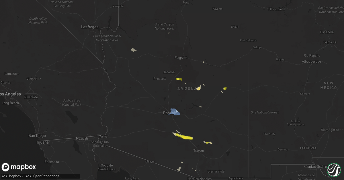
Hail Map in Arizona on July 17, 2022
Get this storm
July 17 map
$229
one time, instant access
Download today. No call, no setup
Keep the $229
Bought the map and want the full workflow? Apply the entire $229 to a subscription within 7 days. None of it is wasted.
Every map, not just this one
This buys you this map. Subscription and you get every map we run, in the markets you choose from a few cities to whole states to nationwide. Plus real-time alerts the moment a storm fires.
Contact data
Name, contact info, occupancy, even credit band for addresses in the footprint. You go from where it hit to who to call.
Become the source they trust
Unlimited branding weather history reports on demand. You already have the documented answer ready for the property owner, and you are the one who showed up with it.
Property data and RoofTrace estimates
Pull up any address you have got, its value and the exact code rules for that jurisdiction, straight from One Click Code. Then RoofTrace estimates the squares, pitch, and roof value, priced the way you price.
Storm reports in Arizona
Arizona
| Date | Description |
|---|---|
| 07/17/20226:05 PM CDT | Downed tree limbs reported. Time radar estimated. |
| 07/17/20222:55 PM CDT | Mix of dime to quarter size hail. |
| 07/17/20227:38 AM CDT | At 1236 PM MST, a severe thunderstorm was located over Wagon Wheel, or over Show Low, moving north at 10 to 15 mph. HAZARD...60 mph wind gusts, quarter size hail, and heavy rainfall. SOURCE...Radar indicated. IMPACT...Hail damage to vehicles is expected. Expect wind damage to roofs, siding, and trees. Locations impacted include... Show Low, Pinetop-lakeside, Lake Of The Woods--Pinetop-lakeside, Linden, Pinedale, Wagon Wheel, Scott Reservoir Campground, Fool Hollow Lake Campground, White Mountain Lake, Lakeside Campground and Lewis Canyon Group Campground. |
| 07/17/20225:12 AM CDT | At 1012 PM MST, severe thunderstorms were located along a line extending from near Castle Hot Springs to near Circle City to 9 miles west of White Tank Mountain Park to near Buckeye, moving northwest at 35 mph. HAZARD...60 mph wind gusts. SOURCE...Radar indicated. IMPACT...Expect damage to roofs, siding, and trees. Locations impacted include... Surprise, Buckeye, Wickenburg, Wittmann, Tonopah, Circle City and Morristown.This includes the following highways...AZ Interstate 10 between mile markers 85 and 114.US Highway 60 between mile markers 88 and 133.AZ Route 74 between mile markers 1 and 15. |
| 07/17/20224:45 AM CDT | At 944 PM MST, severe thunderstorms were located along a line extending from Sun City West to near Luke AFB to Estrella Mountain Ranch, moving west at 25 mph. HAZARD...60 mph wind gusts. SOURCE...Radar indicated. IMPACT...Expect damage to roofs, siding, and trees. Locations impacted include... Glendale, Peoria, Surprise, Avondale, Goodyear, Buckeye, El Mirage, Tolleson, Youngtown, Sun City West, Waddell, Cashion, Circle City, Sun City and Wittmann.This includes the following highways...AZ Interstate 10 between mile markers 106 and 135.US Highway 60 between mile markers 122 and 152.AZ Route 101 between mile markers 2 and 19. |
| 07/17/20223:58 AM CDT | At 858 PM MST, severe thunderstorms were located along a line extending from Desert Ridge Marketplace to Metro Center Mall to South Mountain Park, moving west at 30 mph. HAZARD...60 mph wind gusts. SOURCE...Radar indicated. IMPACT...Expect damage to roofs, siding, and trees. Locations impacted include... Phoenix, Chandler, Glendale, Scottsdale, Tempe, Peoria, Surprise, Avondale, Goodyear, Buckeye, El Mirage, Paradise Valley, Tolleson, Youngtown and Waddell.This includes the following highways...AZ Interstate 10 between mile markers 117 and 161.AZ Interstate 17 between mile markers 195 and 222.AZ Route 51 between mile markers 1 and 15. |
| 07/17/20223:22 AM CDT | At 822 PM MST, a severe thunderstorm was located 7 miles northwest of Chui-Chu, or 12 miles southwest of Casa Grande, moving northwest at 25 mph. HAZARD...60 mph wind gusts and nickel size hail. SOURCE...Radar indicated. IMPACT...Expect damage to roofs, siding, and trees. Locations impacted include... Maricopa, Estrella Sailport, Freeman, Stanfield and Ak- Chin Village.This includes the following highways...AZ Interstate 8 between mile markers 140 and 173.AZ Route 238 between mile markers 37 and 44.AZ Route 347 between mile markers 161 and 174. |
| 07/17/20223:13 AM CDT | At 813 PM MST, severe thunderstorms were located along a line extending from Falcon Field Airport to Mesa to Gilbert City Hall, moving northwest at 30 mph. HAZARD...60 mph wind gusts. SOURCE...Radar indicated. IMPACT...Expect damage to roofs, siding, and trees. Locations impacted include... Phoenix, Mesa, Chandler, Scottsdale, Gilbert, Tempe, Paradise Valley, Laveen, East Mesa, Tempe Marketplace, Papago Park, Piestewa Peak Park, Granite Reef Dam, Falcon Field Airport and Salt River Indian Community.This includes the following highways...AZ Interstate 10 between mile markers 142 and 159.AZ Interstate 17 between mile markers 195 and 209.AZ Route 51 between mile markers 1 and 15. |
| 07/17/20223:00 AM CDT | At 759 PM MST, a severe thunderstorm was located over Arizona City, or 12 miles south of Casa Grande, moving west at 15 mph. HAZARD...60 mph wind gusts and quarter size hail. SOURCE...Radar indicated. IMPACT...Hail damage to vehicles is expected. Expect wind damage to roofs, siding, and trees. Locations impacted include... Chui-Chu, Cockleburr, Shopishk and East Chui-Chu. |
| 07/17/20222:47 AM CDT | At 747 PM MST, a severe thunderstorm was located near Casa Grande, moving northwest at 20 mph. HAZARD...60 mph wind gusts and penny size hail. SOURCE...Radar indicated. IMPACT...Expect damage to roofs, siding, and trees. Locations impacted include... Casa Grande, Maricopa, Stanfield and Ak-Chin Village. This includes the following highways...AZ Interstate 8 between mile markers 160 and 173.AZ Route 347 between mile markers 161 and 173. |
| 07/17/20222:11 AM CDT | At 710 PM MST, a severe thunderstorm was located near Picacho, or 19 miles southeast of Casa Grande, moving west at 25 mph. HAZARD...70 mph wind gusts and ping pong ball size hail, also dense blowing dust. SOURCE...Radar indicated. IMPACT...People and animals outdoors will be injured. Expect hail damage to roofs, siding, windows, and vehicles. Expect considerable tree damage. Wind damage is also likely to mobile homes, roofs, and outbuildings. Locations impacted include... Eloy, Picacho, Chui-Chu, Picacho Peak State Park, Red Rock, North Komelik, Jack Rabbit, Shopishk and East Chui-Chu. |
| 07/17/20221:36 AM CDT | At 636 PM MST, a severe thunderstorm was located 8 miles east of Picacho Peak State Park, or 16 miles northwest of Marana, moving west at 25 mph. HAZARD...60 mph wind gusts and quarter size hail. SOURCE...Radar indicated. IMPACT...Hail damage to vehicles is expected. Expect wind damage to roofs, siding, and trees. Locations impacted include... Eloy, Picacho, Picacho Peak State Park and Red Rock. |
| 07/17/20221:28 AM CDT | At 627 PM MST, a severe thunderstorm was located near San Manuel, or 12 miles south of Mammoth, moving northwest at 35 mph. HAZARD...60 mph wind gusts and nickel size hail. SOURCE...Radar indicated. IMPACT...Expect damage to roofs, siding, and trees. This severe thunderstorm will remain over mainly remote areas of northeastern Pima and southeastern Pinal Counties. |
| 07/17/20221:11 AM CDT | At 610 PM MST, severe thunderstorms were located along a line extending from 6 miles northeast of San Miguel to 19 miles southeast of Topawa, moving west at 10 mph. HAZARD...60 mph wind gusts and quarter size hail. SOURCE...Radar indicated. IMPACT...Hail damage to vehicles is expected. Expect wind damage to roofs, siding, and trees. Locations impacted include... San Miguel, Vamori, Cowlic, Choulic, Newfield, Coldfields, Hashan Chuchg and South Komelik. |
| 07/17/20221:01 AM CDT | At 601 PM MST, a severe thunderstorm was located 15 miles southwest of Dudleyville, or 16 miles southwest of Winkelman, moving northwest at 30 mph. HAZARD...60 mph wind gusts and penny size hail. SOURCE...Radar indicated. IMPACT...Expect damage to roofs, siding, and trees. Locations impacted include... Cactus Forest. |
| 07/17/202212:56 AM CDT | At 556 PM MST, a severe thunderstorm was located near Mount Lemmon/Summerhaven, or 9 miles southeast of Oracle, moving northwest at 15 mph. HAZARD...60 mph wind gusts and quarter size hail. SOURCE...Radar indicated. IMPACT...Hail damage to vehicles is expected. Expect wind damage to roofs, siding, and trees. Locations impacted include... Catalina, Oracle, Saddlebrooke, Mount Lemmon/Summerhaven, Campo Bonito, Oracle Junction and Biosphere 2. |
| 07/17/202212:22 AM CDT | At 522 PM MST, a severe thunderstorm was located 7 miles northeast of Dudleyville, or 7 miles east of Winkelman, moving northwest at 15 mph. HAZARD...60 mph wind gusts and quarter size hail. SOURCE...Radar indicated. IMPACT...Hail damage to vehicles is expected. Expect wind damage to roofs, siding, and trees. Locations impacted include... Kearny, Dudleyville and Aravaipa Canyon Wilderness. |
| 07/17/202212:00 AM CDT | Mesonet station srp25 4.3 n surprise |
| 07/17/202212:00 AM CDT | Exit signs on the interstate damaged and construction trailers flipped over. |
| 07/16/202211:48 PM CDT | Delayed report -- multiple 12 diameter tree trunks snapped just along 107th ave just south of happy valley rd. Mcso has 107th closed. |
| 07/16/202211:47 PM CDT | Awos wind gust from luke afb. |
| 07/16/202211:45 PM CDT | At 445 PM MST, a severe thunderstorm was located 9 miles south of Kitt Peak, or 15 miles southeast of Sells, moving west at 15 mph. HAZARD...60 mph wind gusts and quarter size hail. SOURCE...Radar indicated. IMPACT...Hail damage to vehicles is expected. Expect wind damage to roofs, siding, and trees. Locations impacted include... Sells, Topawa, Ali Chukson, Vamori, Fresnal, Fresnal Canyon, Artesia, South Komelik and Ali Molina. |
| 07/16/202211:45 PM CDT | At 444 PM MST, a severe thunderstorm was located 10 miles north of Kitt Peak, or 23 miles northeast of Sells, moving northwest at 25 mph. HAZARD...60 mph wind gusts and quarter size hail. SOURCE...Radar indicated. IMPACT...Hail damage to vehicles is expected. Expect wind damage to roofs, siding, and trees. Locations impacted include... San Pedro, Queens Well, Santa Rosa Ranch, Sil Nakya and Pan Tak. |
| 07/16/202211:01 PM CDT | At 400 PM MST, a severe thunderstorm was located over Montezuma Castle National Monument, or near Camp Verde, moving northwest at 15 mph. HAZARD...60 mph wind gusts and quarter size hail. SOURCE...Radar indicated. IMPACT...Hail damage to vehicles is expected. Expect wind damage to roofs, siding, and trees. Locations impacted include... Camp Verde, Verde Village, Mcguireville, Village At Oak Creek, Montezuma Castle National Monument, Page Springs, Bridgeport, Montezuma Well, Rimrock, Middle Verde, Lake Montezuma, Cornville, Cottonwood, Wet Beaver Creek Campground, Red Rock State Park, V Bar V Visitors Center and Clear Creek Campgrounds. |
| 07/16/202210:57 PM CDT | 61 mph gust at sky harbor intl. |
| 07/16/202210:50 PM CDT | Trailer park homes destroyed with bountiful scattered debris. |
| 07/16/202210:47 PM CDT | At 346 PM MST, a severe thunderstorm was located 11 miles north of Diamond M Ranch, or 36 miles northeast of Kingman, moving northwest at 20 mph. HAZARD...60 mph wind gusts and small hail. SOURCE...Radar indicated. IMPACT...Expect damage to roofs and trees. Locations impacted include... Highway 66 between Valentine and Peach Springs. |
| 07/16/202210:47 PM CDT | ***delayed report*** barnes rd closed from amarillo valley rd to warren rd due to downed power lines. Timing estimated from radar. |
| 07/16/202210:45 PM CDT | 4 inch diameter tree down. |
| 07/16/202210:41 PM CDT | Large uprooted tree damage. |
| 07/16/202210:40 PM CDT | Spotter measured 62 mph wind gusts with handheld anemometer. |
| 07/16/202210:26 PM CDT | At 326 PM MST, a severe thunderstorm was located near Strawberry, or 18 miles northwest of Payson, moving west at 20 mph. HAZARD...60 mph wind gusts and quarter size hail. SOURCE...Radar indicated. IMPACT...Hail damage to vehicles is expected. Expect wind damage to roofs, siding, and trees. Locations impacted include... Strawberry and Clear Creek Campgrounds. |
| 07/16/202210:26 PM CDT | ***delayed report*** helicopter footage showed multiple downed transmission towers along sr 87. According to adot... Sr 87 is closed between mcdowell rd and shea blvd a |
| 07/16/202210:25 PM CDT | Amazon semi blown over onto its side. |
| 07/16/202210:23 PM CDT | *** 1 inj *** ***delayed report*** mobile home destroyed on roma avenue near sr 87 and gilbert rd. Owner of mobile home was pulled from the rubble and transported to th |
| 07/16/202210:23 PM CDT | Roof ripped off portion of house... Doors blown off of plastic shed. |
| 07/16/202210:15 PM CDT | Large uprooted tree damage. |
| 07/16/202210:15 PM CDT | Demolished shedding with scattered large debris and downed trees. |
| 07/16/202210:15 PM CDT | Delayed report. 5 power poles down near chuichu. Time estimated from radar. |
| 07/16/202210:15 PM CDT | Delayed report -- blown out billboards... Roof damage... Heads of palm trees blown off... Powerline damage... Tiling damage. |
| 07/16/202210:12 PM CDT | Awos station at falcon field - mesa. |
| 07/16/20229:56 PM CDT | At 255 PM MST, a severe thunderstorm was located near and northwest of Madera Canyon, or about 10 miles southeast of Green Valley, moving northwest at 10 mph. HAZARD...60 mph wind gusts and quarter size hail. SOURCE...Radar indicated. IMPACT...Hail damage to vehicles is expected. Expect wind damage to roofs, siding, and trees. Locations impacted include... Sahuarita, Green Valley, Amado, Madera Canyon and Arivaca Junction. |
| 07/16/20229:52 PM CDT | ***delayed report*** approximately 1 mile long stretch of power poles blown over along battaglia dr. Timing estimated from radar. |
| 07/16/20229:42 PM CDT | At 241 PM MST, a severe thunderstorm was located over Haigler Creek, or 12 miles southwest of Forest Lakes, moving southwest at 10 to 15 mph. HAZARD...Up to ping pong ball size hail, up to 60 mph wind gusts, and heavy rainfall. SOURCE...Radar indicated. IMPACT...People and animals outdoors will be injured. Expect hail damage to roofs, siding, windows, and vehicles. Expect wind damage to roofs, siding, and trees. Locations impacted include... Haigler Creek, Young, Haigler Canyon Campground and Alderwood Campground. |
| 07/16/20229:35 PM CDT | At 0735 pm the kazc awos recorded a gust of 58 mph from the ese as a thunderstorm moved over the area. |
| 07/16/20228:58 PM CDT | Corrects previous hail report from 8 sse san manuel. Social media report of one inch hail. |
| 07/16/20228:39 PM CDT | At 138 PM MST, a severe thunderstorm was located near Cedar Creek south of Carrizo, or 27 miles southwest of Show Low, and is nearly stationary. HAZARD...60 mph wind gusts, quarter size hail, and heavy rainfall. SOURCE...Radar indicated. IMPACT...Hail damage to vehicles is expected. Expect wind damage to roofs, siding, and trees. Locations impacted include... Carrizo, Cedar Creek and Fort Apache Reservation. |
| 07/16/20228:16 PM CDT | At 113 PM MST, a severe thunderstorm was located 7 miles east of Show Low, moving northeast at 15 mph. HAZARD...60 mph wind gusts, quarter size hail, and heavy rainfall. SOURCE...Public report of quarter size hail. Radar indicated rotation within the storm. IMPACT...Hail damage to vehicles is expected. Expect wind damage to roofs, siding, and trees. Locations impacted include... Show Low, Scott Reservoir Campground, Fool Hollow Lake Campground and White Mountain Lake. |
All States Impacted by Hail Map on July 17, 2022
Cities Impacted by Hail Map on July 17, 2022
- Wappapello, MO
- McGee, MO
- Elizabethtown, IL
- Equality, IL
- Harrisburg, IL
- Chester, AR
- Rudy, AR
- Marble Hill, MO
- Hoboken, NJ
- Weehawken, NJ
- Astoria, NY
- Union City, NJ
- New York, NY
- Jersey City, NJ
- Secaucus, NJ
- Bronx, NY
- North Bergen, NJ
- West New York, NJ
- Niangua, MO
- Grovespring, MO
- Bee Branch, AR
- Damascus, AR
- Quitman, AR
- Shirley, AR
- Puxico, MO
- Waynesville, MO
- Scottsdale, AZ
- Mill Spring, MO
- Mountain View, MO
- Casa Grande, AZ
- Florence, AZ
- Arizona City, AZ
- Eloy, AZ
- Lost Creek, KY
- Jackson, KY
- Browning, MT
- Camp Verde, AZ
- Laquey, MO
- Falcon, MO
- Birch Tree, MO
- Eminence, MO
- Edgemont, AR
- Greenbrier, AR
- Fairfield Bay, AR
- Heber Springs, AR
- Higden, AR
- Drasco, AR
- Mount Vernon, AR
- Ida, AR
- Mountain View, AR
- Lebanon, MO
- Salem, MO
- Crosby, ND
- Wharncliffe, WV
- Gilbert, WV
- Greenville, MO
- Mountain Grove, MO
- Globe, AZ
- Roosevelt, MN
- Ambrose, ND
- Fortuna, ND
- Rolla, MO
- Newburg, MO
- Cut Bank, MT
- Hartville, MO
- Benson, AZ
- Carrier Mills, IL
- Magazine, AR
- Paris, AR
- Big Falls, MN
- Fairfield, MT
- Summersville, MO
- Young, AZ
- Richland, MO
- Belle Rose, LA
- Oak Ridge, MO
- Friedheim, MO
- Perryville, MO
- Payson, AZ
- Omaha, IL
- Ridgway, IL
- East Glacier Park, MT
- Lynchburg, MO
- Plato, MO
- Asbury, NJ
- Warroad, MN
- Crocker, MO
- Dixon, MO
- Forest Lakes, AZ
- Salem, VA
- Long Valley, NJ
- Ava, MO
- Chadwick, MO
- Oldfield, MO
- Horseshoe Bend, AR
- Ash Flat, AR
- Franklin, AR
- Flagstaff, AZ
- Colonial Beach, VA
- Loretto, VA
- Champlain, VA
- Hustle, VA
- Willow Springs, MO
- Myrtle, MO
- Couch, MO
- Alton, MO
- Pleasant Grove, AR
- Bunker, MO
- Picacho, AZ
- Conway, MO
- Pine, AZ
- Badger, MN
- Roseau, MN
- Woodford, VA
- Fredericksburg, VA
- Manchester, NH
- Mammoth Spring, AR
- Maricopa, AZ
- Roby, MO
- Green Forest, AR
- Berryville, AR
- Rio Rico, AZ
- Cook Sta, MO
- Cherryville, MO
- Amado, AZ
- Tucson, AZ
- Genoa, WV
- Dunlow, WV
- Wesco, MO
- Steelville, MO
- Mesa, AZ
- Forbes, ND
- Bucyrus, MO
- Graff, MO
- Huggins, MO
- Lakeside, AZ
- Show Low, AZ
- Moody, MO
- Caulfield, MO
- Sorrento, FL
- Mount Dora, FL
- Eustis, FL
- Silva, MO
- Galena, MO
- Raleigh, IL
- Galatia, IL
- Eldorado, IL
- Batesville, AR
- Grand Canyon, AZ
- Phillipsburg, MO
- Sedona, AZ
- Sells, AZ
- Camp, AR
- Thayer, MO
- Cave City, AR
- Viola, AR
- Junction, IL
- Mount Pleasant, AR
- Guion, AR
- Orange, VA
- Gordonsville, VA
- Tubac, AZ
- Clinton, AR
- Leslie, AR
- Salol, MN
- Leon, VA
- Brightwood, VA
- Reva, VA
- Mount Lemmon, AZ
- Wellington, FL
- Loxahatchee, FL
- Alsen, ND
- Canton, MS
- Camden, MS
- Jerome, MO
- Oran, MO
- Chaffee, MO
- Fulks Run, VA
- Hackberry, AZ
- Wayne, WV
- East Lynn, WV
- Salem, AR
- Crane, MO
- Jarratt, VA
- Marshfield, MO
- Tumbling Shoals, AR
- Wiseman, AR
- Oxford, AR
- Apopka, FL
- Hardy, AR
- Phoenix, AZ
- Laveen, AZ
- Gilbert, AZ
- Paradise Valley, AZ
- Tempe, AZ
- Charlotte, AR
- Newark, AR
- Cord, AR
- Amagon, AR
- Newport, AR
- Weiner, AR
- Fisher, AR
- Sulphur Rock, AR
- Altus, AR
- Scranton, AR
- Danville, AR
- Belleville, AR
- Havana, AR
- Ola, AR
- Perryville, AR
- Coal Hill, AR
- Dardanelle, AR
- Subiaco, AR
- Casa, AR
- Hartman, AR
- Ozark, AR
- Auburn, NH
- Hooksett, NH
- Circleville, OH
- Stoutsville, OH
- Marana, AZ
- Advance, MO
- Cape Girardeau, MO
- McClure, IL
- Patton, MO
- Leopold, MO
- Glenallen, MO
- Millersville, MO
- Marquand, MO
- Jackson, MO
- Scott City, MO
- Burfordville, MO
- Whitewater, MO
- Tamms, IL
- Bell City, MO
- Sturdivant, MO
- Metropolis, IL
- Thebes, IL
- Gipsy, MO
- Olmsted, IL
- Olive Branch, IL
- Wickliffe, KY
- Mounds, IL
- Cairo, IL
- Barlow, KY
- Zalma, MO
- Miller City, IL
- Brownwood, MO
- Sikeston, MO
- Mound City, IL
- Paducah, KY
- Brookport, IL
- Bloomfield, MO
- Villa Ridge, IL
- Ledbetter, KY
- Charleston, MO
- Kevil, KY
- Benton, MO
- Pulaski, IL
- West Paducah, KY
- Lowndes, MO
- La Center, KY
- Ullin, IL
- Clubb, MO
- Smithland, KY
- Buncombe, IL
- Jonesboro, IL
- Goreville, IL
- Vienna, IL
- Ozark, IL
- Anna, IL
- Cobden, IL
- Dongola, IL
- Alto Pass, IL


